The annual Irrigation System Survey Report, which is published by the Wyoming Water Development Commission, provides a summary of information regarding 28 irrigation districts. These districts lie within a portion of what the Wyoming State Engineer's Office designates as Water Division I. Information regarding the irrigation districts within the Upper Laramie subbasin as listed in the 2003 Irrigation System Survey Report is represented in the following table.
Irrigation Districts |
Surface source |
Acres in district (total) |
District acres irrigated |
Number of users |
| Laramie Valley Irrigation District |
Oasis ditch |
8,636 |
8,636 |
15 |
| Medicine Bow Conservation District |
-- |
-- |
-- |
-- |
| Pioneer Canal-Lake Hattie Irrigation District |
Laramie River |
19,000 |
17,000 |
58 |
| Rock Creek Ditch Company |
Rock Creek |
8,294 |
8,214 |
7 |
| Rock Creek Water Users Association |
-- |
-- |
-- |
-- |
| Toltec Watershed Improvement District |
North Laramie River |
1,754 |
1,754 |
6 |
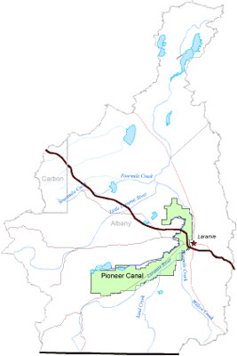
Pioneer Canal – Lake Hattie Irrigation District
The Pioneer Canal was constructed in 1879 and enlarged both in 1884 and during the period 1909 to 1912. The Pioneer Canal diverts water from the Laramie River at a point about three miles downstream of Woods Landing, Wyoming and is about 32 miles long, terminating about three miles northwest of the City of Laramie. The canal provides water for irrigation of approximately 18,360 acres. This system is currently operated by the Pioneer-Lake Hattie Irrigation District, which was formed in 1988.
Below is a map of the Pioneer Canal - Lake Hattie Irrigation District. Click here to enlarge image, view legend, and to print