| |
An aquifer is defined as a geologic formation that is sufficiently water-saturated and permeable to yield a significant quantity of water to wells or springs. The aquifer systems of the Upper Laramie River subbasin are shown on the map below. Aquifer systems currently used and/or available for future development within the Upper Laramie River subbasin include the following:
-
Quaternary Aquifer System (Alluvial deposits);
-
Uaternary Aquifer System (Non-alluvial deposits);
-
Early Tertiary Aquifer System (Wind River and Hanna Formations);
-
Late Cretaceous Aquifer System (Medicine Bow, Mesaverde, and Frontier Formations);
-
Early Cretaceous Aquifer System (Muddy Sandstone and Cloverly Formation
-
Triassic-Jurassic Aquifer System (Sundance Formation); and
-
Late Paleozoic Aquifer System (Casper Formation).
The Quaternary and the Late Paleozoic Aquifer Systems are the most extensively developed aquifer systems for high capacity wells within the Upper Laramie River subbasin.
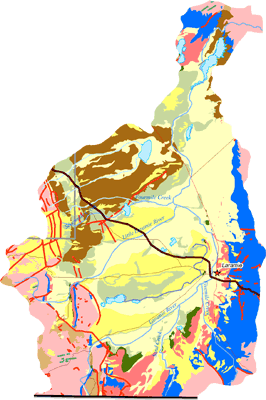
Click on map to enlarge image, view legend, and to print.
. |
|