The annual Irrigation System Survey Report, which is published by the Wyoming Water Development Commission, provides a summary of information regarding 28 irrigation districts. These districts lie within a portion of what the Wyoming State Engineer's Office designates as Water Division I. Information regarding the irrigation districts within the Lower Laramie subbasin as listed in the 2003 Irrigation System Survey Report is represented in the following table.
Irrigation Districts |
Surface source |
Acres in district (total) |
District acres irrigated |
Number of users |
| Gunbarrel Ditch Company |
Wheatland Irrigation District |
2,600 |
2,600 |
12 |
| Wheatland Irrigation District |
Laramie River, Sybille Creek |
54,000 |
-- |
850 |
Wheatland Irrigation District
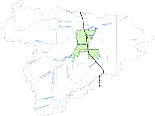
The Wheatland Irrigation District (WID) is located in southeastern Wyoming about 70 miles north of Cheyenne. The district was formed by the Wyoming Development Company with construction between 1883 and 1886 of the Wheatland Tunnel and Canals No. 1 and No. 2. The district diverts water from the Laramie River at the Laramie River Diversion Dam through the Wheatland Tunnel and into Bluegrass and Sybille Creeks. District Canals No. 1 and No. 2 deliver water to district irrigators from Sybille Creek and WID No. 2 Reservoir, respectively. Canal No. 3 flows from Sybille Creek into WID No. 1 Reservoir. The district currently serves 850 users with approximately 54,000 acres of irrigated lands. A map of the Wheatland Irrigation District is shown below.
The Wheatland Irrigation District has experienced water shortages throughout its existence. Construction of WID Reservoirs No. 1 and No. 2 in 1895 and 1901, respectively, was an early attempt to address these shortages. The district continued to cope with shortages, which led to enlargement of Reservoir No. 2 in the late 1950s, followed by enlargement of Reservoir No. 1.
Below is a map showing the Wheatland Irrigation District boundaries within the Lower Laramie River subbasin. Click here to enlarge image, view legend, and to print.