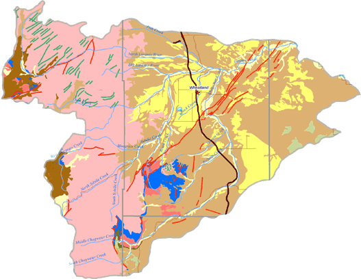
An aquifer is defined as a geologic formation that is sufficiently water-saturated and permeable to yield a significant quantity of water to wells or springs. The aquifer systems of the Lower Laramie River subbasin are shown on the map below. Aquifer systems currently used and/or available for future development within the Lower Laramie River subbasin include the following:
-
Quaternary Aquifer System (Alluvial deposits);
-
Quaternary Aquifer System (Non-alluvial deposits);
-
Late Tertiary Aquifer System (Ogallala, Arikaree Formations, White River Group);
-
Late Cretaceous Aquifer Systems (Lance Formation and Fox Hills Sandstone);
-
Late Paleozoic Aquifer System (Casper Formation); and
-
Precambrian Aquifer System (Precambrian crystalline bedrock units).
The Quaternary and Late Tertiary Aquifer Systems are the most extensively developed aquifer systems within the Lower Laramie River subbasin. These two aquifer systems are the most heavily used for high capacity wells.