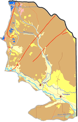
An aquifer is defined as a geologic formation that is sufficiently water-saturated and permeable to yield a significant quantity of water to wells or springs. The aquifer systems of the Guernsey to State Line subbasin are shown on the following map. Aquifer systems currently used and/or available for future development in the Guernsey to State Line subbasin include the following:
-
Quaternary Aquifer System (alluvial deposits);
-
Quaternary Aquifer System (non-alluvial deposits);
-
Late Tertiary Aquifer System (Ogallala and Arikaree Formations, and White River Group);
-
Late Cretaceous Aquifer Systems (Lance Formation and Fox Hills Sandstone);
-
Late Paleozoic Aquifer System (Hartville Formation, and Madison Limestone/Guernsey Formation); and
-
Precambrian Aquifer System (Precambrian crystalline bedrock units).
The Quaternary and Late Tertiary Aquifer Systems are the most extensively developed and used aquifer systems within the Guernsey to State Line subbasin.