|
|
| |
|
|
| |
Agricultural Water Use: Major Diversions

|
|
| |
Collection of information regarding Platte River Basin diversions included photographing selected diversion structures and tabulating Wyoming State Engineer’s Office (SEO) permit information regarding these structures. Major diversions were generally those that are permitted by the SEO to convey 50 cubic feet per second (cfs) or greater flow and were identified by a process including assessing an SEO database of basin diversion information, discussions with SEO hydrographers, and review of the 1999 Tabulation of Adjudicated Surface Water Rights of the State of Wyoming. The advice and assistance of SEO hydrographers, both in the office and in the field, was essential to the successful completion of this work. Some major diversions were not photographed, due either to private property access issues or very remote locations. Click here to view a map of the major diversions that were photographed in the Guernsey to State Line subbasin. Following are diversion photographs and accompanying information for the Guernsey to State Line subbasin.
|
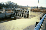
Fort Laramie Canal at Walen Diversion Dam |
Structure number |
GSL-1 |
Wyoming State Engineer’s Office permit number |
P18544D, P5014E, P4883E
|
Permitted conveyance (cubic feet per second, including enlargements) |
721.68 |
Priority dates |
12-06-1904, 04-20-1923, 01-20-1932
|
Location – SEO district number |
14 |
Location – SEO district office |
Torrington |
Location – Qtr/Qtr (if available)/Section/Township/Range |
S11-T26N-R65W
|
Water source |
North Platte River |
Date of photograph |
2-22-2005 |
|
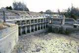
Interstate Canal at Whalen Diversion Dam |
Structure number |
GSL-2 |
Wyoming State Engineer’s Office permit number |
P3409D, P1398E, P4968E
|
Permitted conveyance (cubic feet per second, including enlargements) |
2080.65 + Secondary Supply |
Priority dates |
09-06-1901, 12-06-1904, 09-19-1934
|
Location – SEO district number |
14 |
Location – SEO district office |
Torrington |
Location – Qtr/Qtr (if available)/Section/Township/Range |
S11-T26N-R65W
|
Water source |
North Platte River |
Date of photograph |
2-22-2005 |
|
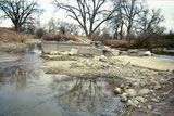
Torrington Ditch |
Structure number |
GSL-3 |
Wyoming State Engineer’s Office permit number |
P187D |
Permitted conveyance (cubic feet per second, including enlargements) |
34.88 |
Priority dates |
11-28-1891 |
Location – SEO district number |
14 |
Location – SEO district office |
Torrington |
Location – Qtr/Qtr (if available)/Section/Township/Range |
S30-T25N-R62W
|
Water source |
North Platte River / Rawhide Creek |
Date of photograph |
2-22-2005 |

|
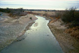
North Platte Ditch |
Structure number |
GSL-4 |
Wyoming State Engineer’s Office permit number |
Territorial |
Permitted conveyance (cubic feet per second, including enlargements) |
53.03 |
Priority dates |
09-2-1883 |
Location – SEO district number |
14 |
Location – SEO district office |
Torrington |
Location – Qtr/Qtr (if available)/Section/Township/Range |
S33-T25N-R62W
|
Water source |
North Platte River |
Date of photograph |
2-22-2005 |
|
Rock Ranch Ditch |
Structure number |
GSL-5 |
Wyoming State Engineer’s Office permit number |
Territorial |
Permitted conveyance (cubic feet per second, including enlargements) |
37.07 |
Priority dates |
Spring 1884 |
Location – SEO district number |
14 |
Location – SEO district office |
Torrington |
Location – Qtr/Qtr (if available)/Section/Township/Range |
S30-T25N-R62W
|
Water source |
North Platte River |
Date of photograph |
2-22-2005 |
|
|
|
| |
|