| |
|
|
| |
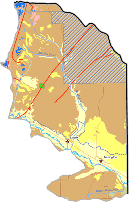
Guernsey Dam to State Line Subbasin Future Groundwater Development Potential
|
|
| |
Depending upon the type of groundwater use and desired water quality and quantity, the aquifer systems have potential for future development in this subbasin. A map of potential groundwater development sites for the Guernsey to State Line subbasin is shown below. The future development potential of the major aquifer systems located within the subbasin is summarized below:
- Considered to be hydrologically connected to the North Platte River and its tributaries, the Quaternary Aquifer System currently yields large quantities of groundwater. The largest use of this aquifer system occurs in the Torrington area. Water quality and susceptibility to contamination will need to be addressed on a local basis. Future development of new irrigation wells in this area is unlikely, but the prospect for wells serving other purposes exists.
- The Late Tertiary Aquifer System has been developed for irrigation, domestic, and stock supplies. Despite its current high level of development in some areas, there appears to be potential for future development. A large portion of this area lies within the Prairie Center Control Area.
Click on map to enlarge image, view legend, and to print. |
|
|