Wyoming State Water Plan
Wyoming State Water Plan
Wyoming Water Development Office
6920 Yellowtail Rd
Cheyenne, WY 82002
Phone: 307-777-7626

Wyoming Water Development Office
6920 Yellowtail Rd
Cheyenne, WY 82002
Phone: 307-777-7626


| SUBJECT: |
Appendix K Surface Water Hydrology |
| PREPARED BY: | HKM Engineering Inc. |
| DATE: | February 2002 |
INTRODUCTION
Water availability models are to be developed to represent dry year, normal year, and wet year hydrologic conditions throughout the Powder/Tongue River Basin Planning area. Several key inputs are necessary to model the water availability including the current irrigated land base, crop water requirements, municipal and industrial surface water demands, and regulation by reservoir storage facilities. This information was developed through the Task 2 work effort. Schematic representations of the water availability models have been developed identifying the appropriate location of model nodes in relation to the various surface water demands, return flows, and storage regulation. Model nodes are located, in large part, at historic streamflow gaging stations in order to take advantage of the historic records of streamflow at these locations. Additionally, it is necessary to locate model nodes at locations with no record of streamflow, to appropriately simulate water use in the various drainages. This memorandum summarizes the methodology used to collect the historic records of streamflow, establish a study period for modeling, and to extend or fill-in the streamflow data where records are unavailable. The methodology used to estimate natural (virgin) streamflow at ungaged model nodes is also discussed in this memorandum.
HISTORIC STREAMFLOW RECORDS
HKM inventoried the available records of streamflow in the Powder/Tongue River Basin. Data from the following four sources were used for this study:
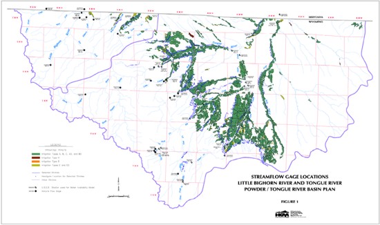
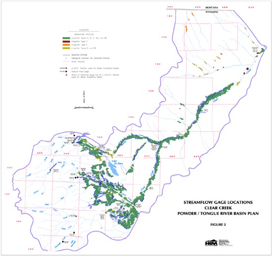
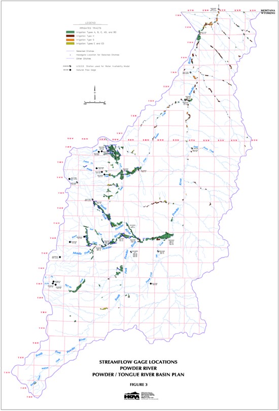
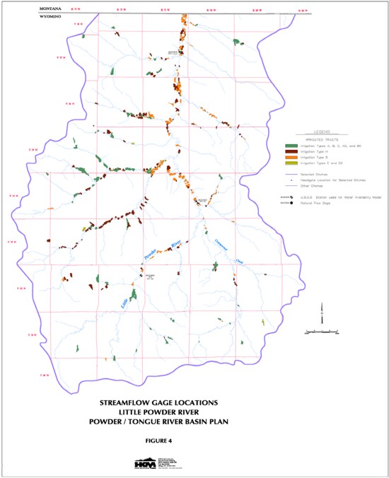
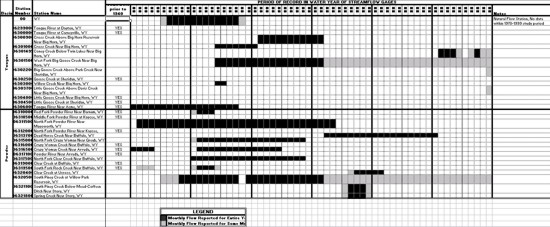
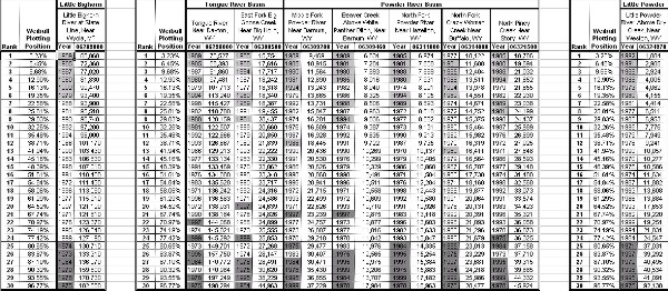
The location of the various streamflow gaging stations are plotted in relation to the significant storage reservoirs and the irrigated lands mapped by HKM (Figures 1 through 4). The streamflow gages that are relatively free from the influence of depletions or storage regulations are characterized as natural flow stations. Where reasonably possible, those gages that are impacted by upstream irrigation depletions were adjusted to remove these effects. The list of streamflow gages inventoried for this study is provided in Table 1.
TABLE 1
STREAMFLOW STATIONS IN THE POWDER-TOUNGE RIVER BASINS
| Basin | Station Number |
Station Name | Natural Flow | Period of Record in
Water Years ** |
Note |
| Little Bighorn | |||||
| 06288600 | Little Bighorn River Below Dayton Gulch Near Burgess Junction, WY | YES | 1983-1987 | ||
| 06288700 | Dry Fork Little Bighorn Below Lick Creek Near Burgess Junction, WY | YES | 1983-1987, 1993-1995 | ||
| 06288960 | Little Bighorn River Near Parkman, WY | YES | 1970-1972 | ||
| 06288975 | Elkhorn Creek Above Fuller Ranch Ditch Near Parkman, WY | YES | 1983-1987 | No winter records in 1985 | |
| 06288990 | West Fork Little Bighorn River Near Parkman, WY | YES | 1970-72, 1983-1987 | No winter records in 1987 | |
| 06289000 | Little Bighorn River at State Line Near Wyola, MT | YES | 1939-current | ||
| 06289100 | Red Canyon Creek Near Parkman, WY | YES | 1982-1990 | No winter records in 1985, 1987 | |
| 06289500 | Little Bighorn River Near Wyola, MT | NO | 1912-1924 | No winter records; Abt. 7 mi. into MT | |
| 06289600 | West Pass Creek Near Parkman, WY | NO | 1983-current | No winter records 1985-1987 | |
| 06289800 | East Pass Creek Near Parkman, WY | YES | 1975-1976 | ||
| 06289820 | East Pass Creek Near Dayton, WY | NO | 1983-current | ||
| 06289870 | Twin Creek Near Parkman, WY | NO | 1983-1990 | No winter records 1985-1987 | |
| 06290000 | Pass Creek Near Wyola, MT | NO | 1939-1975 | Winter records incomplete before 1939; Abt. 4 mi. into MT | |
| 06290500 | Little Bighorn River Below Pass Creek Near Wyola, MT | NO | 1939-1975 | Abt. 13 mi. into MT | |
| 06291200 | Lodge Grass Creek at State Line Near Wyola, MT | YES | 1982-1989 | No winter records 1986 | |
| Tongue | 06296500 | North Fork Tongue River Near Dayton, WY | YES | 1945-1958 | No winter records before 1950 |
| 06297000 | South Fork Tongue River Near Dayton, WY | YES | 1945-1972 | ||
| 06297480 | Tongue River at Tongue Canyon Campground Near Dayton, WY | YES | 1975-1979 | ||
| 06298000 | Tongue River Near Dayton, WY | YES | 1919-1929, 1941-current | Adjusted using Highline Ditch Near Dayton, WY (06297500) as published | |
| 06298480 | Little Tongue River at Steamboat Point Near Dayton, WY | YES | 1975-1976 | ||
| 06298490 | Little Tongue River Above South Fork Little Tongue River Near Dayton, WY | YES | 1975-1976 | ||
| 06298500 | Little Tongue River Near Dayton, WY | YES | 1951-1974 | ||
| 06299000 | Tongue River at Dayton, WY | NO | 1903-1904 | Seasonal (May 1903 to Oct. 1904) | |
| 06299480 | Wolf Creek Below Alden Creek Near Wolf, WY | YES | 1975-1976 | ||
| 06299490 | Wolf Creek Above Red Canyon Creek at Wolf, WY | YES | 1975-1976 | ||
| 06299500 | Wolf Creek at Wolf, WY | YES | 1945-current | No winter records after 1971 | |
| 06300000 | Tongue River at Carneyville, WY | NO | 1911-1917 | Seasonal only | |
| 06300500 | East Fork Big Goose Creek Near Big Horn, WY | YES | 1954-current | No winter records after 1973 | |
| 06300900 | Cross Creek Above Big Horn Reservoir Near Big Horn, WY | NO | 1961-1971 | ||
| 06301000 | Cross Creek Near Big Horn, WY | NO | 1954-1960 | ||
| 06301480 | Coney Creek Above Twin Lakes Near Big Horn, WY | YES | 1991-current | No winter records 1993, 1996, 1998, 1999 | |
| 06301485 | Lost Lake Creek Near Big Horn, WY | YES | 1991-1993 | ||
| 06301490 | Snail Creek Near Big Horn, WY | YES | 1991-1993 | ||
| 06301495 | Coney Creek Below Twin Lakes Near Big Horn, WY | NO | 1991-1994, 1996-current | No winter records some years | |
| 06301500 | West Fork Big Goose Creek Near Big Horn, WY | NO | 1954-current | No winter records after 1971 | |
| 06302000 | Big Goose Creek Near Sheridan, WY | NO | 1929-current | No winter records after 1971; Adjusted for diversions using PK
Ditch & Sheridan City Intake Ditch | |
| 06302200 | Big Goose Creek Above Park Creek Near Sheridan, WY | NO | 1999-current | Jul. - Sep. 1999 | |
| 06302500 | Goose Creek at Sheridan, WY | NO | 1909-1916 | No winter records | |
| 06303000 | Willow Creek Near Big Horn, WY | NO | 1954-1955 | ||
| 06303500 | Little Goose Creek in Canyon Near Big Horn, WY | NO | 1941-current | No winter records after 1971 | |
| 06303700 | Little Goose Creek Above Davis Creek Near Big Horn, WY | NO | 1999-current | Jul. - Sep. 1999 | |
| 06304000 | Little Goose Creek Near Big Horn, WY | NO | 1919-1922 | No winter records 1919 | |
| 06304500 | Little Goose Creek at Sheridan, WY | NO | 1896-1897, 1911-1913 | No winter records | |
| 06305000 | Goose Creek Below Little Goose Creek at Sheridan, WY | NO | 1896-1897 | No winter records | |
| 06305500 | Goose Creek Below Sheridan, WY | NO | 1942-1984 | ||
| 06305700 | Goose Creek Near Acme, WY | NO | 1984-current | ||
| 06306000 | Tongue River Near Acme, WY | NO | 1939-1957 | ||
| 06306100 | Squirrel Creek Near Decker, MT | NO | 1975-1986 | Abt. 3.5 mi. into MT | |
| 06306250 | Prairie Dog Creek Near Acme, WY | NO | WRDS: 1965-1970; USGS: 1971- 1980; SEO: 1981- 1999 |
State data seasonal only | |
| 06306300 | Tongue River at State Line Near Decker, MT | NO | 1960-current | ||
| Powder | 06309200 | Middle Fork Powder River Near Barnum, WY | YES | 1961-current | |
| 06309260 | Buffalo Creek Above North Fork Buffalo Creek Near Arminto, WY | YES | 1975-1979 | ||
| 06309270 | North Fork Buffalo Creek Near Arminto, WY | YES | 1975-1979 | ||
| 06309280 | Buffalo Creek Below North Fork Buffalo Creek Near Arminto, WY | YES | 1975-1979 | ||
| 06309450 | Beaver Creek Below Bayer Creek Near Barnum, WY | YES | 1975-1989 | ||
| 06309460 | Beaver Creek Above White Panther Ditch Near Barnum, WY | YES | 1975-1989 | ||
| 06309500 | Middle Fork Powder River Above Kaycee, WY | NO | 1949-1970, 1984-1992 | ||
| 06310000 | Red Fork Powder River Near Barnum, WY | NO | 1929-1932, 1950-1954 | ||
| 06310500 | Middle Fork Powder River at Kaycee, WY | NO | 1911-1913, 1929-1932 | ||
| 06311000 | North Fork Powder River Near Hazelton, WY | YES | 1946-current | ||
| 06311060 | North Fork Powder River Below Bull Creek Near Hazelton, WY | YES | 1975-1992 | ||
| 06311400 | North Fork Powder River Below Pass Creek Near Mayoworth, WY | NO | 1974-current | ||
| 06311500 | North Fork Powder River Near Mayoworth, WY | NO | 1941-1973 | ||
| 06312000 | North Fork Powder River Near Kaycee, WY | NO | 1911-1912, 1929-1932 | ||
| 06312500 | Powder River Near Kaycee, WY | NO | 1934-1935, 1938-1971, 1979-1980 | ||
| 06313000 | South Fork Powder River Near Kaycee, WY | NO | 1911-1912, 1938-1940, 1950- 1969, 1979-1980, 1983- 1984 |
||
| 06313180 | Dugout Creek Tributary Near Midwest, WY | YES | 1975-1983 | ||
| 06313400 | Salt Creek Near Sussex, WY | NO | 1976-1981, 1983-1993 | ||
| 06313500 | Powder River at Sussex, WY | NO | 1938-1940, 1950-1957, 1978-1999 | ||
| 06313700 | Dead Horse Creek Near Buffalo, WY | NO | 1972-1990 | ||
| 06313950 | North Fork Crazy Woman Creek Below Pole Creek Near Buffalo, WY | YES | 1974-1984 | ||
| 06314000 | North Fork Crazy Woman Creek Near Buffalo, WY | YES | 1942-1949, 1974-1984 | ||
| 06314500 | North Fork Crazy Woman Creek Below Spring Draw Near Buffalo, WY | YES | 1949-1972 | ||
| 06315000 | North Fork Crazy Woman Near Greub, WY | NO | 1950-1968 | ||
| 06315480 | Poison Creek Below Tetley Spring Near Mayoworth, WY | YES | 1975-1976 | ||
| 06315490 | Poison Creek Near Mayoworth, WY | YES | 1975-1976 | ||
| 06315500 | Middle Fork Crazy Woman Creek Near Greub, WY | YES | 1942-1972 | No winter records 1972 | |
| 06316000 | Crazy Woman Creek Near Buffalo, WY | NO | 1929-1932 | No winter records some years | |
| SEO Gage | Crazy Woman Creek at Trabing Bridge Near Buffalo, WY | NO | SEO: 1982-current | Seasonal data only | |
| 06316400 | Crazy Woman Creek at Upper Station Near Arvada, WY | NO | 1963-1970, 1978-1981 | ||
| 06316500 | Crazy Woman Creek Near Arvada, WY | NO | 1940-1944, 1950-1964 | ||
| 06317000 | Powder River at Arvada, WY | NO | 1919-current | No winter records 1919-1930, 1934 | |
| 06317100 | Powder River Near Arvada, WY | NO | 1915-1919 | No winter records | |
| 06317300 | Sourdough Creek Near Buffalo, WY | YES | 1985-1990 | ||
| 06317340 | Little Sourdough Creek Near Buffalo, WY | YES | 1985-1988 | ||
| 06317500 | North Fork Clear Creek Near Buffalo, WY | NO | 1950-1968 | ||
| 06318500 | Clear Creek Near Buffalo, WY | NO | 1894, 1896, 1897-1900, 1917-1928, 1938-1992 |
Records after Oct. 1987 not equivalent due to diversion by City of Buffalo; Adjusted for diversions using 100 acres of irrigated lands upstream and 6 cfs diversion by Buffalo | |
| SEO Gage | Clear Creek in Buffalo City Park Buffalo, WY | NO | WRDS: 1971-1978; SEO: 1987-1999 |
Seasonal data only | |
| 06319000 | Clear Creek at Buffalo, WY | NO | 1903-1905, 1911-1912 | No winter records | |
| 06319470 | South Rock Creek at Forest Boundary Near Buffalo, WY | YES | 1975-1976 | ||
| 06319480 | South Rock Creek Above Red Canyon Near Buffalo, WY | YES | 1975-1976 | ||
| 06319500 | South Fork Rock Creek Near Buffalo, WY | NO | 1941-1943, 1950-1954 | No winter records 1941-1943 | |
| 06320000 | Rock Creek Near Buffalo, WY | NO | 1941-current | No winter records after 1971; Adjusted for irrigation using Mowry Basin Ditch | |
| SEO Gage | Rock Creek at Mouth Near Buffalo, WY | NO | WRDS: 1971-1975, 1977-1978; SEO: 1980-1981, 1983, 1985-1988, 1990-1999 |
Seasonal data only | |
| 06320200 | Clear Creek Below Rock Creek Near Buffalo, WY | NO | USGS: 1976-1981; SEO: 1982-1985, 1987-1999 |
State data mostly seasonal | |
| 06320400 | Clear Creek at Ucross, WY | NO | 1976-1981 | ||
| SEO Gage | Clear Creek Below Healy Reservoir Near Buffalo, WY | NO | 1977-1999 | State data mostly seasonal | |
| 06320500 | South Piney Creek at Willow Park Reservoir, WY | NO | 1945-1957, 1960-current | No winter records before 1948 and after 1971 | |
| 06321000 | South Piney Creek Near Story, WY | NO | 1951-1980 | No winter records 1972-1974 | |
| 06321100 | South Piney Creek Below Mead-Coffeen Ditch Near Story, WY | NO | 1975-1979 | ||
| 06321500 | North Piney Creek Near Story, WY | YES | 1951-1982 | ||
| 06321800 | Spring Creek Near Story, WY | NO | 1975-1979 | ||
| 06323000 | Piney Creek at Kearney, WY | NO | 1902-1906, 1910-1917, 1919-1923, 1941-current |
No winter records some years | |
| SEO Gage | Little Piney Creek, WY | NO | SEO: 1981, 1983, 1985- 1986, 1988, 1991-1999 |
Seasonal data only; from spot measurements | |
| SEO Gage | Piney Creek Below Lake DeSmet Tunnel Intake Near Story, WY | NO | WRDS: 1971-1973, 1977, 1979; SEO: 1980-1984, 1986- 1996 |
Mostly seasonal data | |
| 06323500 | Piney Creek at Ucross, WY | NO | USGS: 1917-1923, 1980-1982; SEO: 1983-1987, 1989- 1998 |
No winter records 1917-1923; State data seasonal only | |
| SEO Gage | Clear Creek at Double Crossing Near Clearmont, WY | NO | WRDS: 1973-1978; SEO: 1980-1996, 1998-1999 |
Seasonal data only | |
| SEO Gage | Clear Creek Below P&F#3 Ditch Near Clearmont, WY | NO | WRDS: 1978; SEO: 1980-1999 | Seasonal data only | |
| 06324000 | Clear Creek Near Arvada, WY | NO | 1915-1919, 1928-1929, 1940-1982 | No winter records before 1929 | |
| 06324500 | Powder River at Moorhead, MT | NO | 1929-1972, 1975-current | Abt. 4 mi. into MT | |
| Little Powder | 06324890 | Little Powder River Below Corral Creek Near Weston, WY | NO | 1978-1981 | |
| 06324925 | Little Powder River Near Weston, WY | NO | 1977-1981 | ||
| 06324970 | Little Powder River Above Dry Creek Near Weston, WY | NO | 1973-current | ||
| Belle Fourche |
06426500 | Belle Fourche River Below Moorcroft, WY | NO | 1943-1970, 1976-1983, 1986-1987, 1991-current |
**Unless otherwise noted, records were obtained from the USGS.
Figure 5 illustrates the period of record for all of the natural flow stations available in the basins. Figure 6 shows the period of record for the non-natural flow stations at model nodes. Figure 7 summarizes the records available for stations not selected for use in the water availability models. These records were typically excluded either because the stations were discontinued many years ago or because records for stations on the same stream at more appropriate locations are available.
As shown in Figures 5 and 6, records from 40 to 50 streamflow gaging stations are available beginning in the 1970s and 1980s in addition to those existing prior to that time.
FIGURE 5
NATURAL FLOW STATIONS IN THE POWDER-TOUNGE RIVER BASINS
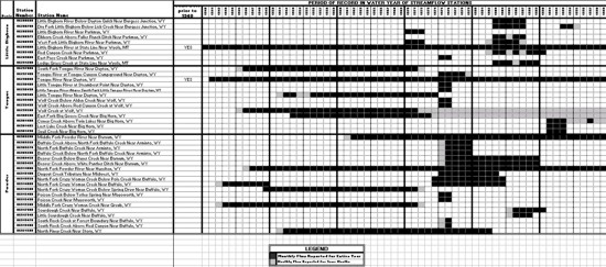
click to enlarge
FIGURE 6
NON-NATURAL FLOW STATIONS IN THE POWDER-TOUNGE RIVER BASINS - SELECTED FOR MODELING
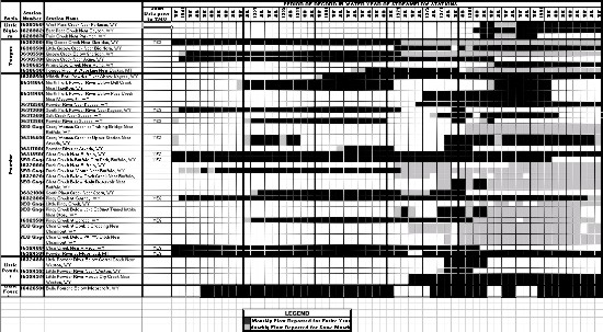
click to enlarge
FIGURE 7
STATIONS IN THE POWDER-TOUNGE RIVER BASINS NOT SELECTED FOR MODELING
click to enlarge
STUDY PERIOD
It is important in any water availability evaluation to select a study period that is long enough to include a variety of hydrologic conditions including an extended period of dry years as well as wet years and normal years. At the same time, it is also important not to select a study period so long that many streamflows must be synthesized to fill-in missing data.
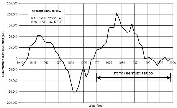
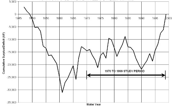
The USGS has maintained a streamflow station on the Tongue River near Dayton (#06298000) since 1919 and continuous records are available from 1941 to present (Table 1). This station is impacted by diversions to the Highline Ditch just upstream of the gage. Natural flow at this station is therefore determined by adding these recorded diversions to the recorded streamflow. The 59-year period of continuous record for this station (1941 through 1999) is selected as the best single representation of long term natural hydrologic conditions in the basin. Figure 8 is a Cumulative Surplus/Deficit plot for the Tongue River near Dayton and represents a running total of the annual deviations from the long-term mean annual streamflow. Downward sloping lines (left to right) represent periods of time during which annual streamflow is less than the long- term mean. Conversely, upward sloping lines represent years which are wetter than average. As shown on Figure 8, the periods from 1941 through 1947 and from 1962 through 1978 can be generally characterized as wet periods, whereas the periods from 1948 through 1961 and from 1979 through 1989 can be generally characterized as dry periods. The period from 1990 through 1999 can generally be characterized as near average. Exceptions to each of these generalities exist within each period. By way of example, 1966 is a dry year within a generally wet period of years and 1984 is a wet year within a generally dry period. Based on an evaluation of the long-term hydrologic conditions on the Tongue River, together with the an understanding of the availability of historic streamflow records, the 30-year period 1970 through 1999 is selected as a candidate study period. Selection of this potential study period is also influenced by the fact that ditch diversion records are available predominantly for the period after 1970. Both streamflow records and ditch diversions records will be needed to develop water availability models that accurately simulate existing water use in the basin. As shown on Figure 8, the average annual flow of the Tongue River near Dayton, for the period 1970 . 1999, is essentially equal to the long-term (1941 . 1999) average annual flow (133,175 AF vs. 133,210 AF).
FIGURE 8
CUMULATIVE SURPLUS/DEFICIT OF ANNUAL HISTORIC FLOWS
TOUNGE RIVER NEAR DAYTON, WY (Station 06298000) - 1941 TO 1999
The representativeness of the potential 1970 to 1999 study period is further evaluated by reviewing long-term natural flow gages that more completely represent the entire Powder/Tongue River Basin, including the Little Bighorn River, the Tongue River, and the Powder River. Three gages with relatively long periods of record are selected for this purpose: 1) Little Bighorn River at State Line (#06289000); 2) Tongue River near Dayton (#06298000); and North Fork Powder River near Hazelton (#06311000). The recorded streamflow at each of these sites either reflects or is adjusted to reflect natural flow, without the influence of man. The annual streamflow at each of these stations for the longest concurrent period of record (1947 . 1999) are summarized in Table 2.
TABLE 2
AVERAGE ANNUAL FLOW
COMPARISON TO 1970-1999
STUDY PERIOD AVERAGE
| YEAR | Annual Flow in Acre-Feet | ||
| Little Bighorn River at State Line Near Wyola, MT 06289000 |
Tongue Near Dayton 06298000 |
North Fork Powder Near Hazelton 06311000 | |
| 1947 | 132,030 | 162,878 | 13,906 |
| 1948 | 102,260 | 131,476 | 9,462 |
| 1949 | 93,250 | 120,409 | 10,017 |
| 1950 | 78,340 | 112,752 | 8,873 |
| 1951 | 94,970 | 134,751 | 7,763 |
| 1952 | 98,470 | 133,919 | 11,231 |
| 1953 | 92,550 | 119,860 | 9,382 |
| 1954 | 88,230 | 103,095 | 5,178 |
| 1955 | 98,040 | 122,448 | 10,253 |
| 1956 | 80,480 | 107,076 | 8,116 |
| 1957 | 114,990 | 124,900 | 11,243 |
| 1958 | 87,300 | 101,807 | 9,414 |
| 1959 | 104,190 | 122,788 | 9,191 |
| 1960 | 71,260 | 84,561 | 5,812 |
| 1961 | 65,400 | 86,151 | 5,006 |
| 1962 | 95,040 | 134,761 | 15,031 |
| 1963 | 126,220 | 159,248 | 12,706 |
| 1964 | 157,060 | 182,715 | 13,592 |
| 1965 | 146,190 | 171,865 | 13,469 |
| 1966 | 83,510 | 85,379 | 5,694 |
| 1967 | 133,180 | 158,525 | 19,339 |
| 1968 | 142,730 | 186,786 | 15,748 |
| 1969 | 118,280 | 140,406 | 10,297 |
| 1970 | 159,600 | 170,984 | 10,137 |
| 1971 | 121,810 | 136,242 | 11,584 |
| 1972 | 111,430 | 138,031 | 8,818 |
| 1973 | 133,310 | 149,701 | 9,131 |
| 1974 | 130,710 | 145,021 | 8,001 |
| 1975 | 182,880 | 198,294 | 15,883 |
| 1976 | 123,370 | 134,000 | 12,204 |
| 1977 | 115,910 | 133,134 | 8,882 |
| 1978 | 170,730 | 197,249 | 18,963 |
| 1979 | 93,400 | 107,713 | 10,405 |
| 1980 | 81,830 | 97,481 | 7,931 |
| 1981 | 95,510 | 122,507 | 7,608 |
| 1982 | 97,200 | 118,780 | 13,633 |
| 1983 | 106,830 | 135,628 | 13,118 |
| 1984 | 136,970 | 170,772 | 14,335 |
| 1985 | 72,360 | 88,393 | 6,974 |
| 1986 | 101,170 | 129,213 | 10,860 |
| 1987 | 77,020 | 91,860 | 9,735 |
| 1988 | 93,900 | 120,159 | 7,889 |
| 1989 | 68,060 | 76,527 | 8,693 |
| 1990 | 103,430 | 138,184 | 9,213 |
| 1991 | 110,400 | 133,469 | 12,926 |
| 1992 | 90,470 | 122,866 | 12,580 |
| 1993 | 96,740 | 126,667 | 13,847 |
| 1994 | 98,000 | 113,240 | 8,105 |
| 1995 | 126,540 | 157,750 | 15,254 |
| 1996 | 113,090 | 136,583 | 13,603 |
| 1997 | 121,120 | 144,068 | 15,384 |
| 1998 | 107,010 | 115,427 | 12,443 |
| 1999 | 127,190 | 145,292 | 17,182 |
| Avg 47-99 | 108,905 | 131,770 | 11,057 |
| Avg 70-99 | 112,266 | 133,175 | 11,511 |
The average annual flow for the period 1970 to 1999 is relatively close to the average annual flow for the longer-term period (1% to 4% wetter) for the three stations. Surplus / Deficit plots for each of these three stations for the 1947 to 1999 period are shown on Figures 9, 10, and 11.
FIGURE 9
CUMULATIVE SURPLUS/DEFICIT OF ANNUAL HISTORIC FLOWS
LITTLE BIGHORN RIVER AT STATE LINE NEAR WYOLA, MT (Station 06289000)
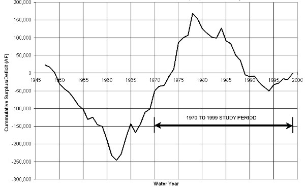
FIGURE 10
CUMULATIVE SURPLUS/DEFICIT OF ANNUAL HISTORIC FLOWS
TOUNGE RIVER NEAR DAYTON, WY (Station 06298000)
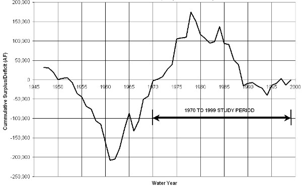
FIGURE 11
CUMULATIVE SURPLUS/DEFICIT OF ANNUAL HISTORIC FLOWS
NORTH FORK POWDER RIVER NEAR HAZELTON, WY (Station 06311000)
On the Little Bighorn River, the period 1970 to 1999 includes the extended dry periods from 1979 through 1983 and 1985 through 1994 as well as the wet period from 1971 through 1978. This period also contains three out of six of the driest years of the 1947 . 1999 records including 1985, 1987, and 1989. The period also contains three out of six of the wettest years of record in 1970, 1975, and 1978. The driest and wettest years are defined here as those with exceedance or non-exceedance probabilities of less than approximately 10 percent.
On the Tongue River, the period 1970 to 1999 includes the extended dry periods 1979 to 1982 and 1985 to 1989 as well as the wet period from 1971 to 1978. Similar to the Little Bighorn, this period contains three out of six of the driest years of the 1947 . 1999 records for the Tongue River including 1985, 1987, and 1989. The period also contains three out of six of the wettest years of record in 1970, 1975, and 1978.
The 1970 to 1999 period on the North Fork Powder River contains the dry periods from 1972 through 1974, 1979 through 1981 and 1985 through 1990 as well as the wet period 1995 through 1999. This period also contains two of the six driest years of the 1947 . 1999 records in 1981 and 1985 and 4 of the six wettest years of record in 1975, 1978, 1997, and 1999.
In summary, the period 1970 through 1999 contains extended periods of dry years including some of the driest years of record as well as periods of normal and wet hydrologic conditions. This period also has the greatest abundance of recorded streamflow data and ditch diversion data and therefore requires less data synthesis. A study period of 1970 through 1999 is therefore appropriate for purposes of water availability modeling for the Powder/Tongue River Basin Plan.
The remainder of this memorandum describes the methodologies used to determine the typical dry year, normal year, and wet year monthly flows required at each of the model nodes.
DATA EXTENSION
The spreadsheet modeling approach used for the Basin Plan relies on both records of natural flow as well as records from stations impacted by upstream diversions or regulation. Natural flow is supplied to the model, where available, at the headwater nodes and non-natural flow records at downstream gaging stations are used to calibrate the model to historic conditions. Monthly streamflows must therefore be estimated for both categories of gaging stations for those months, during the study period, with no recorded streamflow data.
The monthly record extension approach used in this study follows the procedure used by the USGS in recent studies in Montana (USGS WRI 89-4165, 1989: USGS WRI 89-4082, 1989). This mixed-station procedure uses the best base station from among all available base stations to fill in each month of missing data for a given gage. It is therefore possible that several different base stations may be used to fill in different months of missing data for a given station. The base station producing the smallest standard error of prediction is used for each particular month. The monthly record extension procedure also offers the option of using cyclic or noncyclic equations to fill in missing records. If the cyclic option is selected, an extension equation is computed for each month using only concurrent streamflows for the month. If the noncyclic option is selected, a single extension equation is computed using all concurrent streamflows. The smallest standard error criterion is used to select between the cyclic or noncyclic option for each month of missing record. For this study, the cyclic option is used only if the base station and the short record station have at least five concurrent monthly streamflows. The noncyclic option is used in all other cases. The technique used to estimate missing values in this study was developed by Hirsch and is referred to as MOVE.1 (Maintenance of Variance Extension, Type 1). This technique offers the advantage over ordinary least-squares regression of preserving the variance of the unextended records (Alley and Burns, 1983). The MOVE.1 technique differs from ordinary least-squares regression in that ordinary regression minimizes the squared vertical deviations of the response variable from the regression line, whereas the MOVE.1 technique minimizes the areas of the right triangles formed by the horizontal and vertical deviations from the regression line (USGS WRI 89-4165, 1989). This procedure is carried out using a computer program developed by the USGS.
The USGS and SEO streamflow stations are first divided into natural flow stations and non-natural flow stations. The stations are then further divided into hydrologically similar groups with each group having at least one gage with sufficient data to develop relationships based on concurrent streamflow for the entire study period. The monthly flow extension procedure is performed for each of these groupings of monthly streamflow data. There is a certain amount of overlap in hydrologic similarity among the various groupings. Some streamflow stations are therefore included in multiple groups. Records from the long- term natural flow stations are also included with some of the non-natural flow groupings where appropriate to provide adequate data for extending the records through the entire study period. The station groupings and the resulting coefficients of determination (R2) are provided in Table 3 and Table 4 respectively for the natural flow stations and the non-natural flow stations. The coefficient of determination is defined as the proportion of variation in the independent variable that can be explained by variation in the dependent variable (DeVore, 1987). The higher the value of R2, the stronger the relationship between the two variables. A perfect relationship would have an R2 = 1.0. Regression of hydrologic data resulting in R2 > 0.7 is typically considered strong enough for data estimating. This criterion was used in evaluating the results of the regression analyses. The results of the MOVE.1 analyses are provided in Appendix A.
As shown in Tables 3 and 4, in some instances no significant correlation (R2<0.7) could be found using concurrent monthly streamflows between any base station and the short record station. Annual flow regression rather than monthly flow regression was performed in these instances to fill-in the missing streamflow data. The results of this analysis including the base station record used to fill-in the missing data at the short record station, the regression equation, and the resulting coefficient of determination (R2) are summarized in Table 5. The supporting computations and graphic displays of the results of the annual flow regression analyses are provided in Appendix B. As noted in Table 5, in a few cases, no significant correlation (R2<0.7) could be found using the annual flow regression either. These stations were dropped from the study. The monthly streamflows for the years of missing data were estimated by applying the average monthly distribution for the period of recorded streamflow to the estimated total annual flow. For those instances when records for some months are available, the recorded streamflows are used and subtracted from the estimated annual total. The remaining months of missing data are then filled-in using the average monthly distribution for these months applied to the total remaining streamflow for the partial year.
TABLE 3
CORRELATION RESULTS BASED ON MONTHLY DATA
NATURAL FLOW STATIONS IN THE POWDER-TOUNGE BASIN
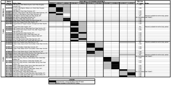
click to enlarge
TABLE 4
CORRELATION RESULTS BASED ON MONTHLY DATA
NON-NATURAL FLOW STATIONS IN THE POWDER-TOUNGE BASIN
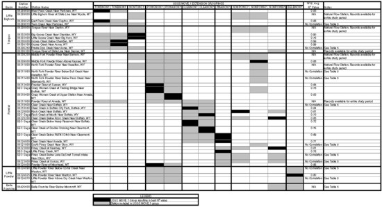
click to enlarge
TABLE 5
CORRELATION RESULTS BASED ON ANNUAL DATA
STATIONS IN THE POWDER-TOUNGE BASIN
| Basin | Station Number |
Station Name | Natural Flow |
Station Used in Regression | R2 Value | Regression Equation | Notes |
| Little Bighorn | 06289100 | Red Canyon Creek Near Parkman, WY | YES | Little Bighorn River at State Line, Near Wyola, MT (Station 06289000) | 0.90 | Y = 0.025398X - 1391.2 | |
| 06289870 | Twin Creek Near Parkman, WY | NO | Little Bighorn River at State Line, Near Wyola, MT (Station 06289000) | 0.74 | Y = 0.11280X - 7152.9 | ||
| Tongue | 06301485 | Lost Lake Creek Near Big Horn, WY | YES | No Correlation | Unable to find significant correlation with any available station | ||
| 06301490 | Snail Creek Near Big Horn, WY | YES | No Correlation | Unable to find significant correlation with any available station | |||
| 06306250 | Prairie Dog Creek Near Acme, WY | NO | Powder River at Arvada, WY (Station 06317000) | 0.87 | Y = 0.072738X + 15381 | ||
| Powder | 06311060 | North Fork Powder River Below Bull Creek Near Hazelton, WY | NO | North Fork Powder River Near Hazelton, WY (Station 06311000) | 0.83 | Y = 0.95976X + 2154.2 | |
| 06311400 | North Fork Powder River Below Pass Creek Near Mayoworth, WY | NO | North Fork Powder River Near Hazelton, WY (Station 06311000) | 0.79 | Y = 1.4351X + 9453.4 | ||
| 06312500 | Powder River Near Kaycee, WY | NO | Middle Fork Powder River Near Barnum, WY (Station 06309200) | 0.87 | Y = 2.6695X + 36671 | ||
| 06313000 | South Fork Powder River Near Kaycee, WY | NO | Powder River at Arvada, WY (Station 06317000) | 0.91 | Y = 0.13407X + 307.34 | ||
| 06313180 | Dugout Creek Tributary Near Midwest, WY | YES | No Correlation | Unable to find significant correlation with any available station | |||
| 06313400 | Salt Creek Near Sussex, WY | NO | Powder River at Sussex, WY (Station 06313500) | 0.75 | Y = 0.14172X + 10815 | ||
| 06317340 | Little Sourdough Creek Near Buffalo, WY | YES | Powder River at Arvada, WY (Station 06317000) | 0.99 | Y = 0.0047854X - 207.81 | ||
| 06318500 | Clear Creek Near Buffalo, WY | NO | Clear Creek in Buffalo City Park, Buffalo, WY (SEO Gage) | 0.80 | Y = 0.73548X + 24886 | ||
| 06321000 | South Piney Creek Near Story, WY | NO | North Fork Powder River Near Hazelton, WY (Station 06311000) | 0.84 | Y = 2.8480X + 28319 | ||
| SEO Gage | Piney Creek Below Lake DeSmet Tunnel Intake Near Story, WY | NO | Piney Creek at Kearney, WY (Station 06323000) | 0.88 | Y = 0.97670X - 10655 | Irrigation Season Regression | |
| 06323500 | Piney Creek at Ucross, WY | NO | Piney Creek at Kearney, WY (Station 06323000) | 0.78 | Y = 1.0792X - 3636.2 | Irrigation Season Regression | |
| Little Powder | 06324890 | Little Powder River Below Corral Creek Near Weston, WY | NO | Belle Fourche River Below Moorcroft, WY (Station 06426500) | 0.99 | Y = 0.18483X - 463.92 | |
| 06324970 | Little Powder River Above Dry Creek Near Weston, WY | NO | Belle Fourche River Below Moorcroft, WY (Station 06426500) | 0.80 | Y = 0.90409X+ 475.71 | ||
| Belle Fourche | 06426500 | Belle Fourche River Below Moorcroft, WY | NO | Inflow to Keyhole Reservoir (USBR Gage) | 0.87 | Y = 0.57098X - 386.15 | Applied to Monthly Values |
The average monthly and annual streamflows for the 1970 to 1999 study period, for the natural flow streamflow stations and the non-natural flow streamflow stations are summarized in Table 6 and Table 7 respectively. The recorded and extended monthly streamflows for each year of the 1970 to 1999 study period are provided in Appendix C for each gaging station selected for use in the water availability models.
TABLE 6
SUMMARY OF AVERAGE MONTHLY AND ANNUAL FLOWS (1970 TO 1999)
NATURAL FLOW STATIONS IN THE POWDER-TOUNGE RIVER BASINS
| Basin | Station Number | Station Name | Average Streamflow for 1970-1999 in Acre-Feet | ||||||||||||
| Oct | Nov | Dec | Jan | Feb | Mar | Apr | May | Jun | Jul | Aug | Sep | Annual | |||
| Little Bighorn | |||||||||||||||
| 06288600 | Little Bighorn River Below Dayton Gulch Near Burgess Junction, WY | 414 | 301 | 268 | 238 | 195 | 215 | 358 | 3,600 | 6,008 | 1,685 | 779 | 463 | 14,524 | |
| 06288700 | Dry Fork Little Bighorn Below Lick Creek Near Burgess Junction, WY | 1,855 | 1,599 | 1,498 | 1,383 | 1,223 | 1,326 | 1,709 | 6,248 | 9,433 | 4,505 | 2,644 | 2,029 | 35,452 | |
| 06288960 | Little Bighorn River Near Parkman, WY | 4,011 | 3,353 | 3,098 | 2,864 | 2,479 | 2,777 | 3,771 | 17,119 | 27,107 | 11,347 | 6,045 | 4,433 | 88,404 | |
| 06288975 | Elkhorn Creek Above Fuller Ranch Ditch Near Parkman, WY | 114 | 100 | 92 | 86 | 75 | 88 | 141 | 486 | 618 | 202 | 135 | 124 | 2,261 | |
| 06288990 | West Fork Little Bighorn River Near Parkman, WY | 939 | 794 | 734 | 672 | 593 | 671 | 896 | 3,868 | 5,800 | 2,421 | 1,355 | 1,040 | 19,783 | |
| 06289000 | Little Bighorn River at State Line Near Wyola, MT | 5,420 | 4,574 | 4,258 | 3,958 | 3,479 | 3,880 | 5,154 | 21,093 | 32,321 | 14,270 | 7,920 | 5,957 | 112,266 | |
| 06289100 | Red Canyon Creek Near Parkman, WY | 35 | 32 | 26 | 28 | 23 | 42 | 216 | 561 | 242 | 65 | 32 | 28 | 1,330 | |
| 06289800 | East Pass Creek Near Parkman, WY | 469 | 389 | 366 | 338 | 303 | 328 | 547 | 1,899 | 2,298 | 1,062 | 638 | 508 | 9,145 | |
| 06291200 | Lodge Grass Creek at State Line Near Wyola, MT | 464 | 352 | 316 | 288 | 242 | 271 | 558 | 3,619 | 5,268 | 1,760 | 780 | 531 | 14,449 | |
| Tongue | |||||||||||||||
| 06297000 | South Fork Tongue River Near Dayton, WY | 1,424 | 1,033 | 942 | 803 | 652 | 741 | 1,839 | 14,823 | 22,367 | 6,444 | 2,527 | 1,656 | 55,251 | |
| 06297480 | Tongue River at Tongue Canyon Campground Near Dayton, WY | 5,064 | 3,935 | 3,623 | 3,295 | 2,824 | 3,107 | 6,129 | 31,109 | 42,528 | 15,621 | 7,855 | 5,653 | 130,743 | |
| 06298000 | Tongue River Near Dayton, WY | 5,130 | 3,954 | 3,642 | 3,315 | 2,825 | 3,117 | 6,186 | 31,983 | 43,180 | 16,162 | 7,951 | 5,730 | 133,175 | |
| 06298480 | Little Tongue River at Steamboat Point Near Dayton, WY | 134 | 94 | 83 | 72 | 58 | 69 | 249 | 2,165 | 3,088 | 726 | 274 | 167 | 7,179 | |
| 06298490 | Little Tongue River Above South Fork Little Tongue River Near Dayton, WY | 98 | 67 | 58 | 50 | 40 | 46 | 139 | 1,641 | 2,643 | 591 | 200 | 118 | 5,691 | |
| 06298500 | Little Tongue River Near Dayton, WY | 225 | 158 | 139 | 124 | 105 | 118 | 402 | 3,299 | 4,503 | 1,144 | 427 | 268 | 10,912 | |
| 06299480 | Wolf Creek Below Alden Creek Near Wolf, WY | 471 | 341 | 304 | 267 | 219 | 255 | 784 | 6,063 | 8,521 | 2,214 | 855 | 537 | 20,831 | |
| 06299490 | Wolf Creek Above Red Canyon Creek at Wolf, WY | 536 | 404 | 364 | 329 | 276 | 308 | 784 | 5,804 | 8,126 | 2,169 | 849 | 540 | 20,489 | |
| 06299500 | Wolf Creek at Wolf, WY | 539 | 399 | 356 | 317 | 271 | 298 | 854 | 5,767 | 7,980 | 2,237 | 926 | 603 | 20,547 | |
| 06300500 | East Fork Big Goose Creek Near Big Horn, WY | 426 | 284 | 220 | 204 | 154 | 171 | 557 | 5,296 | 10,978 | 3,740 | 1,096 | 698 | 23,824 | |
| 06301480 | Coney Creek Above Twin Lakes Near Big Horn, WY | 30 | 18 | 14 | 10 | 8 | 9 | 49 | 1,091 | 1,781 | 534 | 83 | 48 | 3,675 | |
| Powder | 06309200 | Middle Fork Powder River Near Barnum, WY | 457 | 416 | 370 | 331 | 295 | 424 | 2,125 | 9,807 | 5,212 | 1,061 | 527 | 433 | 21,457 |
| 06309260 | Buffalo Creek Above North Fork Buffalo Creek Near Arminto, WY | 31 | 28 | 23 | 20 | 17 | 28 | 218 | 1,350 | 649 | 101 | 38 | 28 | 2,531 | |
| 06309270 | North Fork Buffalo Creek Near Arminto, WY | 86 | 79 | 70 | 62 | 55 | 79 | 370 | 1,639 | 915 | 200 | 103 | 84 | 3,742 | |
| 06309280 | Buffalo Creek Below North Fork Buffalo Creek Near Arminto, WY | 0 | 0 | 0 | 0 | 0 | 0 | 34 | 1,918 | 950 | 51 | 2 | 1 | 2,956 | |
| 06309450 | Beaver Creek Below Bayer Creek Near Barnum, WY | 185 | 166 | 143 | 126 | 111 | 156 | 519 | 1,787 | 1,141 | 429 | 247 | 192 | 5,202 | |
| 06309460 | Beaver Creek Above White Panther Ditch Near Barnum, WY | 612 | 568 | 546 | 518 | 476 | 561 | 997 | 2,211 | 1,674 | 911 | 695 | 610 | 10,379 | |
| 06311000 | North Fork Powder River Near Hazelton, WY | 294 | 220 | 180 | 144 | 120 | 142 | 603 | 3,864 | 4,037 | 1,111 | 471 | 325 | 11,511 | |
| 06313950 | North Fork Crazy Woman Creek Below Pole Creek Near Buffalo, WY | 629 | 474 | 387 | 307 | 257 | 301 | 1,142 | 5,582 | 5,774 | 1,983 | 918 | 645 | 18,399 | |
| 06314000 | North Fork Crazy Woman Creek Near Buffalo, WY | 640 | 481 | 395 | 316 | 265 | 307 | 1,152 | 5,490 | 5,637 | 1,987 | 924 | 655 | 18,249 | |
| 06314500 | North Fork Crazy Woman Creek Below Spring Draw Near Buffalo, WY | 558 | 412 | 337 | 264 | 217 | 269 | 1,184 | 7,726 | 8,139 | 2,222 | 917 | 624 | 22,869 | |
| 06315480 | Poison Creek Below Tetley Spring Near Mayoworth, WY | 214 | 175 | 150 | 127 | 112 | 126 | 346 | 1,172 | 1,155 | 490 | 279 | 218 | 4,564 | |
| 06315490 | Poison Creek Near Mayoworth, WY | 246 | 202 | 176 | 150 | 132 | 151 | 387 | 1,232 | 1,220 | 542 | 320 | 251 | 5,009 | |
| 06315500 | Middle Fork Crazy Woman Creek Near Greub, WY | 707 | 551 | 470 | 391 | 334 | 411 | 1,290 | 5,891 | 6,016 | 2,072 | 1,031 | 759 | 19,923 | |
| 06317300 | Sourdough Creek Near Buffalo, WY | 70 | 52 | 44 | 34 | 28 | 34 | 107 | 775 | 905 | 265 | 112 | 78 | 2,504 | |
| 06317340 | Little Sourdough Creek Near Buffalo, WY | 37 | 22 | 7 | 3 | 2 | 5 | 206 | 214 | 139 | 36 | 16 | 25 | 712 | |
| 06319470 | South Rock Creek at Forest Boundary Near Buffalo, WY | 447 | 341 | 280 | 227 | 187 | 217 | 900 | 5,431 | 5,744 | 1,722 | 714 | 491 | 16,701 | |
| 06319480 | South Rock Creek Above Red Canyon Near Buffalo, WY | 426 | 325 | 264 | 213 | 177 | 205 | 870 | 5,367 | 5,703 | 1,675 | 689 | 471 | 16,385 | |
| 06321500 | North Piney Creek Near Story, WY | 800 | 626 | 511 | 423 | 354 | 439 | 1,817 | 10,506 | 10,318 | 2,733 | 1,139 | 842 | 30,508 | |
TABLE 7
SUMMARY OF AVERAGE MONTHLY AND ANNUAL FLOWS (1970 TO 1999)
NON-NATURAL FLOW STATIONS IN THE POWDER-TOUNGE RIVER BASINS
| Basin | Station Number | Station Name | Average Streamflow for 1970-1999 in Acre-Feet | ||||||||||||
| Oct | Nov | Dec | Jan | Feb | Mar | Apr | May | Jun | Jul | Aug | Sep | Annual | |||
| Little Bighorn | |||||||||||||||
| 06289600 | West Pass Creek Near Parkman, WY | 522 | 476 | 441 | 419 | 407 | 497 | 770 | 2,023 | 2,007 | 810 | 488 | 495 | 9,355 | |
| 06289820 | East Pass Creek Near Dayton, WY | 621 | 575 | 543 | 531 | 519 | 629 | 958 | 2,666 | 2,800 | 905 | 469 | 530 | 11,746 | |
| 06289870 | Twin Creek Near Parkman, WY | 108 | 92 | 119 | 328 | 236 | 741 | 847 | 1,656 | 349 | 154 | 115 | 87 | 4,833 | |
| Tongue | |||||||||||||||
| 06302000 | Big Goose Creek Near Sheridan, WY | 2,307 | 1,727 | 1,576 | 1,427 | 1,199 | 1,336 | 2,247 | 13,175 | 27,034 | 8,560 | 4,642 | 3,625 | 68,855 | |
| 06303500 | Little Goose Creek in Canyon Near Big Horn, WY | 1,855 | 1,369 | 1,274 | 1,147 | 968 | 1,076 | 2,082 | 10,835 | 14,826 | 6,582 | 5,236 | 3,425 | 50,702 | |
| 06305500 | Goose Creek Below Sheridan, WY | 6,692 | 5,855 | 5,109 | 4,570 | 4,971 | 6,223 | 8,284 | 26,807 | 40,099 | 10,115 | 4,047 | 5,595 | 128,367 | |
| 06305700 | Goose Creek Near Acme, WY | 6,848 | 5,984 | 5,215 | 4,660 | 5,076 | 6,364 | 8,494 | 27,713 | 41,776 | 10,431 | 4,120 | 5,725 | 132,406 | |
| 06306250 | Prairie Dog Creek Near Acme, WY | 2,785 | 2,192 | 1,835 | 1,286 | 2,567 | 5,705 | 2,784 | 3,701 | 2,327 | 1,416 | 1,730 | 2,350 | 30,678 | |
| 06306300 | Tongue River at State Line Near Decker, MT | 16,187 | 13,719 | 11,317 | 11,134 | 13,110 | 19,427 | 21,867 | 73,969 | 98,409 | 29,613 | 11,756 | 13,340 | 333,850 | |
| Powder | |||||||||||||||
| 06309500 | Middle Fork Powder River Above Kaycee, WY | 2,812 | 2,642 | 2,490 | 2,387 | 2,235 | 2,693 | 5,676 | 14,882 | 9,586 | 3,978 | 2,759 | 2,581 | 54,721 | |
| 06311060 | North Fork Powder River Below Bull Creek Near Hazelton, WY | 240 | 169 | 159 | 129 | 119 | 143 | 367 | 3,188 | 4,121 | 2,014 | 1,524 | 1,028 | 13,202 | |
| 06311400 | North Fork Powder River Below Pass Creek Near Mayoworth, WY | 1,326 | 1,138 | 1,139 | 1,110 | 994 | 1,089 | 1,613 | 4,891 | 5,510 | 2,835 | 2,410 | 1,917 | 25,972 | |
| 06312500 | Powder River Near Kaycee, WY | 5,062 | 6,385 | 6,481 | 5,606 | 6,441 | 8,416 | 8,944 | 27,066 | 15,875 | 1,006 | 888 | 1,783 | 93,950 | |
| 06313000 | South Fork Powder River Near Kaycee, WY | 172 | 237 | 163 | 190 | 1,350 | 7,672 | 5,987 | 9,131 | 2,072 | 602 | 1,729 | 11 | 29,316 | |
| 06313400 | Salt Creek Near Sussex, WY | 2,257 | 1,820 | 1,706 | 1,849 | 2,577 | 4,243 | 3,003 | 5,395 | 4,120 | 3,062 | 1,940 | 1,853 | 33,825 | |
| 06313500 | Powder River at Sussex, WY | 10,088 | 8,646 | 7,430 | 7,200 | 10,592 | 17,746 | 17,475 | 38,478 | 26,121 | 9,211 | 4,476 | 4,899 | 162,362 | |
| SEO Gage | Crazy Woman Creek at Trabing Bridge Near Buffalo, WY | 329 | 223 | 218 | 196 | 150 | 189 | 1,697 | 8,924 | 13,287 | 3,211 | 1,242 | 978 | 30,644 | |
| 06316400 | Crazy Woman Creek at Upper Station Near Arvada, WY | 1,688 | 1,356 | 1,036 | 885 | 1,627 | 2,517 | 3,386 | 9,747 | 8,975 | 2,196 | 1,151 | 769 | 35,333 | |
| 06317000 | Powder River at Arvada, WY | 11,144 | 9,646 | 7,235 | 6,773 | 11,517 | 23,619 | 21,176 | 52,067 | 42,800 | 14,235 | 6,162 | 5,400 | 211,773 | |
| 06318500 | Clear Creek Near Buffalo, WY | 2,253 | 1,583 | 1,220 | 909 | 759 | 1,009 | 2,710 | 12,305 | 17,834 | 8,639 | 3,929 | 2,749 | 55,899 | |
| SEO Gage | Clear Creek in Buffalo City Park Buffalo, WY | 1,886 | 1,397 | 1,138 | 947 | 1,277 | 1,972 | 2,407 | 9,746 | 14,070 | 4,659 | 1,414 | 1,254 | 42,167 | |
| 06320000 | Rock Creek Near Buffalo, WY | 894 | 653 | 587 | 525 | 437 | 490 | 993 | 7,108 | 9,142 | 3,800 | 2,729 | 1,558 | 28,916 | |
| SEO Gage | Rock Creek at Mouth Near Buffalo, WY | 1,572 | 1,322 | 1,026 | 927 | 1,272 | 2,245 | 1,360 | 5,460 | 7,121 | 1,755 | 929 | 918 | 25,907 | |
| 06320200 | Clear Creek Below Rock Creek Near Buffalo, WY | 3,672 | 3,132 | 2,571 | 2,386 | 2,774 | 4,084 | 5,349 | 17,212 | 23,059 | 7,586 | 3,034 | 3,074 | 77,933 | |
| SEO Gage | Clear Creek Below Healy Reservoir Near Buffalo, WY | 2,601 | 1,730 | 1,299 | 1,079 | 1,454 | 2,483 | 3,739 | 14,926 | 20,747 | 7,964 | 3,380 | 2,772 | 64,174 | |
| 06321000 | South Piney Creek Near Story, WY | 2,068 | 1,539 | 1,514 | 1,257 | 961 | 1,032 | 1,555 | 5,964 | 20,205 | 12,621 | 9,042 | 5,535 | 63,293 | |
| 06323000 | Piney Creek at Kearney, WY | 1,886 | 2,307 | 2,059 | 1,875 | 1,607 | 2,038 | 4,072 | 15,796 | 23,765 | 6,122 | 2,061 | 1,265 | 64,853 | |
| SEO Gage | Little Piney Creek, WY | 784 | 751 | 591 | 583 | 709 | 964 | 945 | 1,620 | 1,489 | 881 | 602 | 689 | 10,608 | |
| SEO Gage | Piney Creek Below Lake DeSmet Tunnel Intake Near Story, WY | 1,524 | 1,056 | 741 | 664 | 613 | 864 | 1,953 | 10,657 | 20,258 | 5,591 | 2,118 | 1,431 | 47,470 | |
| 06323500 | Piney Creek at Ucross, WY | 3,450 | 3,413 | 2,641 | 2,362 | 1,632 | 2,969 | 3,928 | 12,580 | 20,834 | 7,887 | 5,206 | 3,718 | 70,620 | |
| SEO Gage | Clear Creek at Double Crossing Near Clearmont, WY | 8,484 | 7,580 | 6,042 | 5,208 | 5,866 | 9,456 | 9,217 | 27,303 | 42,211 | 14,623 | 7,589 | 6,807 | 150,386 | |
| SEO Gage | Clear Creek Below P&F#3 Ditch Near Clearmont, WY | 6,464 | 5,750 | 3,619 | 3,474 | 5,276 | 9,697 | 8,968 | 24,292 | 38,482 | 10,460 | 4,558 | 4,444 | 125,484 | |
| 06324000 | Clear Creek Near Arvada, WY | 7,050 | 6,494 | 4,356 | 4,151 | 5,773 | 9,919 | 10,332 | 25,700 | 38,174 | 11,742 | 5,498 | 5,462 | 134,651 | |
| 06324500 | Powder River at Moorhead, MT | 18,021 | 16,072 | 10,330 | 10,928 | 18,963 | 36,118 | 29,810 | 73,536 | 79,314 | 27,131 | 11,758 | 10,494 | 342,475 | |
| Little Powder | 06324890 | Little Powder River Below Corral Creek Near Weston, WY | 8 | 16 | 23 | 57 | 182 | 1,022 | 138 | 1,239 | 103 | 267 | 38 | 0 | 3,093 |
| 06324925 | Little Powder River Near Weston, WY | 637 | 128 | 74 | 360 | 2,640 | 4,275 | 1,982 | 3,093 | 1,600 | 463 | 275 | 161 | 15,688 | |
| 06324970 | Little Powder River Above Dry Creek Near Weston, WY | 823 | 260 | 174 | 580 | 2,501 | 4,299 | 1,602 | 4,205 | 1,992 | 748 | 404 | 284 | 17,873 | |
| Belle Fourche |
06426500 | Belle Fourche River Below Moorcroft, WY | 682 | 203 | 149 | 420 | 1,761 | 4,664 | 2,268 | 5,169 | 2,134 | 997 | 515 | 281 | 19,243 |
NATURAL FLOW AT UNGAGED MODEL NODES
Records of streamflow are used to the extent available to represent natural flow at model nodes. However, to fully represent water use in the various drainages, estimates of natural flow are also required at several model nodes where records from USGS or SEO streamflow stations are unavailable. HKM evaluated several alternatives for estimating natural flow at these locations including:
Monthly natural flows have been developed through this study at 40 streamflow stations in the Powder/Tongue River Basin. A second alternative is therefore to utilize this data to develop a localized regression equation for estimating natural flow at the ungaged sites. Unfortunately the mean basin elevation for these natural flow stations are typically greater than 7,000 feet. Whereas, the majority of the drainages contributing to the ungaged model nodes have mean basin elevations less than 7,000 feet. A regression equation developed from the recorded natural flow data set would not be applicable to the sites where natural flow estimates are required. Alternative 2 was therefore not selected.
The USGS is currently updating the work originally developed by Lowham in the report "Streamflows in Wyoming" (USGS, 1988). Unfortunately, at the time of this writing, that work is several months away from completion. The 1988 USGS report however presents regression equations, which rely on drainage area and average annual precipitation or mean basin elevation to estimate mean annual flow. The equation for the mountainous region is applicable for drainages with mean basin elevations from 5,000 to 10,800 feet. Only one ungaged model node has a mean basin elevation less than 5,000 feet (Prairie Dog Creek with a MBE of 4550). The USGS regression equation for the mountainous region is selected as the most appropriate alternative for estimating natural flow at most of the ungaged model nodes. The regression equation is as follows:
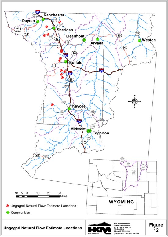
Qa = 0.0015 A1.01 (ELEV/1,000)2.88The reasonableness of the estimates of average annual flow are evaluated by comparing the estimated unit runoff (acre-feet per square mile) to the recorded unit runoff at the nearest natural flow station during the 1970 to 1999 study period. The average annual natural flow is, in some instances, adjusted based on this comparison. The estimated average annual flow and the comparison to unit runoff at the nearest natural flow station are summarized in Table 8 for the ungaged model nodes. The locations of these nodes are shown on Figure 12.
Where: Qa is mean annual flow in cubic feet per second,
A is contributing drainage area in square miles, and
ELEV is mean basin elevation in feet.
TABLE 8
ESTIMATED AVERAGE ANNUAL NATURAL FLOW AT UNGAGED MODEL NODES
| Basin | Site | Stream Type |
Drainage Area (sq. mi.) |
Mean Basin Elevation (ft) |
Estimated Average Annual Runoff | 1970-1999 Average Annual Flow at Nearest Natural Flow Gage | Note | Selected Average Annual AF | |||
| Annual AF | AF/sq. mi. | Gage # | MBE | Runoff/ sq. mi. | |||||||
| Tongue | Rapid Creek Just Below Little Rapid Creek in Section 32, T55N, R85W | Perennial | 13.9 | 6720 | 3742 | 269 | 06299500 | 7700 | 544 | Flow from USGS equation seems reasonable | 3,742 |
| Beaver Creek at Bottom of Section 26, T55N, R85W | Perennial | 8.26 | 5160 | 1034 | 125 | 06299500 | 7700 | 544 | Flow from USGS equation seems reasonable | 1,034 | |
| Soldier Creek at Right Edge of Section 28, T56N, R85W | Perennial | 18.7 | 5100 | 2281 | 122 | 06299500 | 7700 | 544 | Flow from USGS equation seems reasonable | 2,281 | |
| Prairie Dog Creek Just Above Dutch Creek in Section 34, T57N, R83W | Perennial | 122.7 | NA | 20,3324 | 1664 | 063062503 | NA | 1664 | Flow transferred from naturalized USGS Station 06306250 | 20,3324 | |
| Powder | Red Fork Powder River Just Below North & South Forks Red Fork Powder River in Section 29, T44N, R84W | Perennial | 114 | 7670 | 45866 | 402 | 06309460 | 7180 | 429 | Flow from USGS equation seems reasonable | 45,866 |
| Kelly Creek at Top of Section 21, T49N, R82W | Perennial | 10.9 | 5980 | 2092 | 192 | 06314000 | 8440 | 406 | Flow from USGS equation seems reasonable | 2,092 | |
| Little North Fork Crazy Woman Creek Just Below Grossett Canyon in Section 14, T49N, R83W | Perennial | 12.5 | 7570 | 4737 | 379 | 06314000 | 8440 | 406 | Flow from USGS equation seems reasonable | 4,737 | |
| Muddy Creek at Diversion Near East Side of Section 35, T49N, R83W | Perennial | 11.8 | 7500 | 4351 | 369 | 06314000 | 8440 | 406 | Flow from USGS equation seems reasonable | 4,351 | |
| Billy Creek at Diversion to O.Malley Draw in Section 13, T48N, R83W | Perennial | 9.64 | 7410 | 3426 | 355 | 06315490 | 7820 est | 203 | Flow from USGS equation too high . use 203 AF/sq. mi. | 1,957 | |
| Little Piney Creek Just Below Bear Gulch in Section 28, T53N, R83W | Perennial | 14.8 | NA | 7,3364 | 4964 | SEO Gage3 | NA | 4964 | Flow transferred from naturalized SEO Station on Little | 7,3364 | |
| North & South Forks Shell Creek (Combined), at Confluence of Little North Fork Shell Creek and North Fork Shell Creek in Section 11, and Confluence of Unnamed Tributary & South Fork Shell Creek in Section 14; all in T52N, R83W | Perennial | 15.4 | 5340 | 2141 | 139 | 06319480 | 9200 est | 405 | Flow from USGS equation seems reasonable | 2,141 | |
| Johnson Creek at Top of Section 22, T51N, R83W | Perennial | 7.26 | 6850 | 2052 | 283 | 06319480 | 9200 est | 405 | Flow from USGS equation seems reasonable | 2,052 | |
| French Creek at Penrose Ditch Diversion in Section 27, T51N, R83W | Perennial | 13.4 | 7490 | 4928 | 368 | 06319480 | 9200 est | 405 | Flow from USGS equation seems reasonable | 4,928 | |
| Notes: | 1. USGS equation for average annual flow, from WRIR 88-4045 = 0.0015A1.01(MBE/1000)2.88. 2. Average annual flow at USGS natural flow gages based on recorded and/or filled in data for 1970-99 study period. 3. Naturalized gage flow based on recorded and filled in data for the 1970-99 sudy period. |
In addition to average annual natural flow at the ungaged model nodes, it is necessary to generate sequential monthly flows at these sites for all years of the study period. This is accomplished by selecting a natural flow gaging station having similar hydrologic characteristics and multiplying the sequential monthly flows at the gaged location by the ratio of the ungaged average annual natural flow to the gaged average annual natural flow. The time distribution of monthly flows at the ungaged sites is, therefore, represented by the streamflow at similar gaged sites. The average monthly and annual streamflows for the 1970 to 1999 study period, for the ungaged model nodes are summarized in Table 9. The estimated monthly natural flows for each year of the 1970 to 1999 study period are provided in Appendix E for each ungaged model node.
TABLE 9
SUMMARY OF AVERAGE MONTHLY AND ANNUAL FLOWS (1970 TO 1999)
UNGAGED NATURAL FLOW NODES IN THE POWDER-TOUNGE RIVER BASINS
| Basin | Station Name | Estimated Average Streamflow for 1970-1999 in Acre-Feet | ||||||||||||
| Oct | Nov | Dec | Jan | Feb | Mar | Apr | May | Jun | Jul | Aug | Sep | Annual | ||
| Tongue | Rapid Creek Just Below Little Rapid Creek in Section 32, T55N, R85W | 98 | 73 | 65 | 58 | 49 | 54 | 156 | 1,050 | 1,453 | 407 | 169 | 110 | 3,742 |
| Beaver Creek at Bottom of Section 26, T55N, R85W | 27 | 20 | 18 | 16 | 14 | 15 | 43 | 290 | 402 | 113 | 47 | 30 | 1,034 | |
| Soldier Creek at Right Edge of Section 28, T56N, R85W | 60 | 44 | 39 | 35 | 30 | 33 | 95 | 640 | 886 | 248 | 103 | 67 | 2,281 | |
| Prairie Dog Creek Just Above Dutch Creek in Section 34, T57N, R83W | 487 | 1,314 | 3,453 | 2,229 | 3,493 | 2,296 | 1,963 | 1,560 | 1,253 | 886 | 725 | 673 | 20,3321 | |
| Powder | Red Fork Powder River Just Below North & South Forks Red Fork Powder River in Section 29, T44N, R84W | 2,706 | 2,511 | 2,415 | 2,290 | 2,104 | 2,477 | 4,405 | 9,771 | 7,396 | 4,024 | 3,071 | 2,695 | 45,866 |
| Kelly Creek at Top of Section 21, T49N, R82W | 73 | 55 | 45 | 36 | 30 | 35 | 132 | 629 | 646 | 228 | 106 | 75 | 2,092 | |
| Little North Fork Crazy Woman Creek Just Below Grossett Canyon in Section 14, T49N, R83W | 166 | 125 | 103 | 82 | 69 | 80 | 299 | 1,425 | 1,463 | 516 | 240 | 170 | 4,737 | |
| Muddy Creek at Diversion Near East Side of Section 35, T49N, R83W | 153 | 115 | 94 | 75 | 63 | 73 | 275 | 1,309 | 1,344 | 474 | 220 | 156 | 4,351 | |
| Billy Creek at Diversion to O.Malley Draw in Section 13, T48N, R83W | 96 | 79 | 69 | 59 | 52 | 59 | 151 | 481 | 477 | 212 | 125 | 98 | 1,957 | |
| Little Piney Creek Just Below Bear Gulch in Section 28, T53N, R83W | 324 | 421 | 625 | 676 | 1,295 | 1,250 | 811 | 544 | 470 | 309 | 338 | 273 | 7,3361 | |
| North & South Forks Shell Creek (Combined), at Confluence of Little North Fork Shell Creek and North Fork Shell Creek in Section 11, and Confluence of Unnamed Tributary & South Fork Shell Creek in Section 14; all in T52N, R83W | 56 | 42 | 35 | 28 | 23 | 27 | 114 | 701 | 745 | 219 | 90 | 62 | 2,141 | |
| Johnson Creek at Top of Section 22, T51N, R83W | 53 | 41 | 33 | 27 | 22 | 26 | 109 | 672 | 714 | 210 | 86 | 59 | 2,052 | |
| French Creek at Penrose Ditch Diversion in Section 27, T51N, R83W | 128 | 98 | 80 | 64 | 53 | 62 | 262 | 1,614 | 1,715 | 504 | 207 | 142 | 4,928 | |
Note: 1. The monthly and annual flows for Prairie Dog Creek and Little Piney Creek are the average of the dry, normal, and wet year monthly and annual flows.
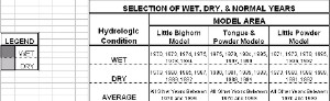
WET, DRY, AND NORMAL YEARS
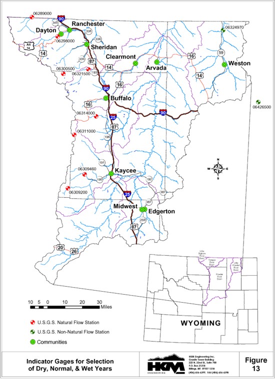
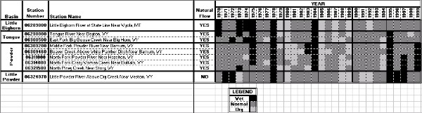
Water availability models are to be developed to represent dry year, normal year, and wet year hydrologic conditions throughout the Powder/Tongue River Basin. To this end, the annual streamflows for the 1970 to 1999 study period developed through the surface water hydrology work are ranked and divided into these three hydrologic categories. Indicator gages are selected for this purpose, to represent hydrologic conditions for the entire geographic area of the Powder/Tongue River Basin. To the extent possible, natural flow stations, free from transbasin diversion, irrigation depletions, or storage regulation are selected. One exception, Little Powder River above Dry Creek (#06324970) which is impacted by irrigation depletions was selected to represent hydrologic conditions in the Little Powder drainage. The nine indicator gages are shown on Figure 13. The years with non-exceedance probabilities of 20 percent or less (the driest 20 percent) were selected as dry years. Similarly, the years with exceedance probabilities of 20 percent or less (the wettest 20 percent) were selected as wet years. The remaining 60 percent of the years represent normal years. The dry years, normal years, and wet years for the indicator gages are illustrated on Figure 14. As can be seen, the hydrologic conditions from year to year vary from location to location (i.e. dry years, wet years, and normal years do not occur at all locations simultaneously). Some general conclusions are however evident. For example, 1980, 1985, 1988, and 1989 are dry years at most locations. Whereas, 1975 1978, 1984, and 1995 are wet years at most locations.
FIGURE 14
WET, DRY, AND NORMAL YEARS FOR INDICATOR STATIONS IN THE POWDER-TOUNGE RIVER BASINS
click to enlarge
Water use in the Tongue River and Powder River are interrelated through transbasin diversions including the Mead Coffeen Ditch, Piney Cruse Ditch, and the Prairie Dog Ditch. Because of this interrelationship, the years selected to represent the various hydrologic conditions must be consistent for all locations within each of these two river basins. Water use in the Little Bighorn River is essentially independent of water use in the other river basins. Similarly, water use in the Little Powder River drainage is also independent of water use in the other drainages. The driest 20 percent and wettest 20 percent of the years at each of the indicator gages are listed in Figure 15. The years selected to represent dry years, wet years, and normal years for the Little Bighorn River basin, the Tongue and Powder River basins, and the Little Powder River basin are also summarized in Figure 15.
FIGURE 15
SELECTION OF WET, DRY, AND NORMAL YEARS FOR MODELING
click to enlarge
The average monthly and annual streamflow for the natural flow stations for dry years, normal years, and wet years are provided in Tables 10, 11, and 12 respectively. The average monthly and annual streamflow for the non-natural flow stations for dry years, normal years, and wet years are provided in Tables 13, 14, and 15 respectively. Finally, the average monthly and annual streamflow for the ungaged model nodes for dry years, normal years, and wet years are provided in Tables 16, 17, and 18 respectively.
TABLE 10
SUMMARY OF DRY YEAR MONTHLY AND ANNUAL FLOWS (1970 TO 1999)
NATURAL FLOW STATIONS IN THE POWDER-TOUNGE RIVER BASINS
| Basin | Station Number | Station Name | Average Streamflow for 1970-1999 in Acre-Feet | ||||||||||||
| Oct | Nov | Dec | Jan | Feb | Mar | Apr | May | Jun | Jul | Aug | Sep | Annual | |||
| Little Bighorn | |||||||||||||||
| 06288600 | Little Bighorn River Below Dayton Gulch Near Burgess Junction, WY | 383 | 293 | 270 | 230 | 186 | 199 | 396 | 2,737 | 2,400 | 1,220 | 631 | 406 | 9,348 | |
| 06288700 | Dry Fork Little Bighorn Below Lick Creek Near Burgess Junction, WY | 1,781 | 1,540 | 1,467 | 1,330 | 1,157 | 1,254 | 1,685 | 4,567 | 4,393 | 2,990 | 2,106 | 1,666 | 25,935 | |
| 06288960 | Little Bighorn River Near Parkman, WY | 3,804 | 3,159 | 2,990 | 2,746 | 2,375 | 2,648 | 3,934 | 12,923 | 11,513 | 6,948 | 4,513 | 3,536 | 61,087 | |
| 06288975 | Elkhorn Creek Above Fuller Ranch Ditch Near Parkman, WY | 104 | 97 | 90 | 81 | 70 | 83 | 145 | 327 | 258 | 145 | 119 | 101 | 1,621 | |
| 06288990 | West Fork Little Bighorn River Near Parkman, WY | 911 | 765 | 710 | 645 | 563 | 627 | 872 | 2,647 | 2,377 | 1,526 | 1,041 | 824 | 13,505 | |
| 06289000 | Little Bighorn River at State Line Near Wyola, MT | 5,168 | 4,347 | 4,130 | 3,815 | 3,330 | 3,687 | 5,332 | 16,225 | 14,538 | 9,057 | 6,063 | 4,832 | 80,523 | |
| 06289100 | Red Canyon Creek Near Parkman, WY | 23 | 24 | 19 | 21 | 16 | 23 | 126 | 260 | 103 | 34 | 20 | 21 | 689 | |
| 06289800 | East Pass Creek Near Parkman, WY | 450 | 377 | 359 | 329 | 293 | 315 | 616 | 1,506 | 1,362 | 863 | 587 | 468 | 7,524 | |
| 06291200 | Lodge Grass Creek at State Line Near Wyola, MT | 445 | 356 | 322 | 284 | 238 | 262 | 607 | 2,835 | 2,606 | 1,242 | 690 | 464 | 10,349 | |
| Tongue | |||||||||||||||
| 06297000 | South Fork Tongue River Near Dayton, WY | 1,253 | 926 | 859 | 714 | 604 | 671 | 2,638 | 15,853 | 9,285 | 2,993 | 1,616 | 1,228 | 38,639 | |
| 06297480 | Tongue River at Tongue Canyon Campground Near Dayton, WY | 4,618 | 3,659 | 3,455 | 2,989 | 2,624 | 2,850 | 8,122 | 32,437 | 20,874 | 8,460 | 5,619 | 4,552 | 100,258 | |
| 06298000 | Tongue River Near Dayton, WY | 4,654 | 3,681 | 3,473 | 3,002 | 2,633 | 2,862 | 8,224 | 33,196 | 21,910 | 9,160 | 5,672 | 4,587 | 103,051 | |
| 06298480 | Little Tongue River at Steamboat Point Near Dayton, WY | 119 | 85 | 79 | 65 | 54 | 60 | 335 | 2,105 | 1,413 | 441 | 190 | 128 | 5,073 | |
| 06298490 | Little Tongue River Above South Fork Little Tongue River Near Dayton, WY | 85 | 59 | 54 | 44 | 36 | 41 | 209 | 1,748 | 926 | 239 | 115 | 83 | 3,639 | |
| 06298500 | Little Tongue River Near Dayton, WY | 200 | 143 | 132 | 108 | 90 | 101 | 528 | 3,159 | 2,144 | 692 | 306 | 208 | 7,811 | |
| 06299480 | Wolf Creek Below Alden Creek Near Wolf, WY | 423 | 313 | 291 | 241 | 205 | 227 | 1,036 | 5,941 | 4,067 | 1,352 | 610 | 419 | 15,122 | |
| 06299490 | Wolf Creek Above Red Canyon Creek at Wolf, WY | 499 | 380 | 355 | 300 | 258 | 284 | 1,025 | 5,696 | 3,926 | 1,334 | 610 | 423 | 15,089 | |
| 06299500 | Wolf Creek at Wolf, WY | 496 | 370 | 344 | 287 | 244 | 270 | 1,106 | 5,662 | 3,972 | 1,426 | 678 | 478 | 15,331 | |
| 06300500 | East Fork Big Goose Creek Near Big Horn, WY | 355 | 243 | 221 | 176 | 143 | 163 | 918 | 6,291 | 6,407 | 1,855 | 700 | 573 | 18,042 | |
| 06301480 | Coney Creek Above Twin Lakes Near Big Horn, WY | 25 | 15 | 13 | 10 | 8 | 9 | 88 | 1,282 | 1,059 | 153 | 46 | 38 | 2,746 | |
| Powder | 06309200 | Middle Fork Powder River Near Barnum, WY | 366 | 344 | 335 | 299 | 259 | 320 | 2,163 | 5,973 | 1,485 | 523 | 351 | 336 | 12,754 |
| 06309260 | Buffalo Creek Above North Fork Buffalo Creek Near Arminto, WY | 23 | 22 | 21 | 18 | 15 | 20 | 211 | 755 | 132 | 36 | 22 | 21 | 1,294 | |
| 06309270 | North Fork Buffalo Creek Near Arminto, WY | 70 | 65 | 64 | 57 | 50 | 61 | 387 | 1,033 | 269 | 98 | 67 | 64 | 2,284 | |
| 06309280 | Buffalo Creek Below North Fork Buffalo Creek Near Arminto, WY | 0 | 0 | 0 | 0 | 0 | 0 | 10 | 932 | 123 | 3 | 0 | 0 | 1,067 | |
| 06309450 | Beaver Creek Below Bayer Creek Near Barnum, WY | 167 | 145 | 128 | 110 | 89 | 119 | 461 | 804 | 454 | 252 | 180 | 153 | 3,060 | |
| 06309460 | Beaver Creek Above White Panther Ditch Near Barnum, WY | 600 | 544 | 538 | 521 | 456 | 513 | 889 | 1,247 | 860 | 647 | 558 | 508 | 7,882 | |
| 06311000 | North Fork Powder River Near Hazelton, WY | 271 | 200 | 155 | 121 | 97 | 116 | 961 | 2,983 | 1,847 | 587 | 305 | 226 | 7,867 | |
| 06313950 | North Fork Crazy Woman Creek Below Pole Creek Near Buffalo, WY | 596 | 463 | 368 | 276 | 227 | 260 | 1,652 | 4,799 | 3,037 | 1,122 | 596 | 451 | 13,847 | |
| 06314000 | North Fork Crazy Woman Creek Near Buffalo, WY | 599 | 475 | 373 | 285 | 232 | 264 | 1,648 | 4,661 | 3,031 | 1,127 | 598 | 451 | 13,744 | |
| 06314500 | North Fork Crazy Woman Creek Below Spring Draw Near Buffalo, WY | 510 | 374 | 287 | 222 | 177 | 212 | 1,878 | 6,015 | 3,677 | 1,130 | 577 | 423 | 15,483 | |
| 06315480 | Poison Creek Below Tetley Spring Near Mayoworth, WY | 209 | 173 | 145 | 117 | 100 | 111 | 453 | 1,024 | 717 | 339 | 209 | 169 | 3,766 | |
| 06315490 | Poison Creek Near Mayoworth, WY | 241 | 202 | 171 | 139 | 120 | 133 | 502 | 1,091 | 777 | 382 | 242 | 197 | 4,195 | |
| 06315500 | Middle Fork Crazy Woman Creek Near Greub, WY | 659 | 513 | 416 | 339 | 282 | 327 | 1,881 | 4,814 | 3,223 | 1,256 | 730 | 569 | 15,009 | |
| 06317300 | Sourdough Creek Near Buffalo, WY | 64 | 45 | 36 | 25 | 22 | 28 | 153 | 457 | 433 | 152 | 75 | 56 | 1,545 | |
| 06317340 | Little Sourdough Creek Near Buffalo, WY | 16 | 11 | 3 | 1 | 1 | 2 | 106 | 95 | 55 | 12 | 5 | 8 | 314 | |
| 06319470 | South Rock Creek at Forest Boundary Near Buffalo, WY | 414 | 308 | 240 | 189 | 152 | 181 | 1,425 | 4,299 | 2,691 | 882 | 466 | 347 | 11,594 | |
| 06319480 | South Rock Creek Above Red Canyon Near Buffalo, WY | 395 | 293 | 227 | 178 | 143 | 170 | 1,383 | 4,239 | 2,637 | 850 | 445 | 330 | 11,228 | |
| 06321500 | North Piney Creek Near Story, WY | 751 | 587 | 459 | 371 | 295 | 342 | 2,571 | 8,859 | 4,307 | 1,475 | 776 | 606 | 21,400 | |
TABLE 11
SUMMARY OF NORMAL YEAR MONTHLY AND ANNUAL FLOWS (1970 TO 1999)
NATURAL FLOW STATIONS IN THE POWDER-TOUNGE RIVER BASINS
| Basin | Station Number | Station Name | Average Streamflow for 1970-1999 in Acre-Feet | ||||||||||||
| Oct | Nov | Dec | Jan | Feb | Mar | Apr | May | Jun | Jul | Aug | Sep | Annual | |||
| Little Bighorn | |||||||||||||||
| 06288600 | Little Bighorn River Below Dayton Gulch Near Burgess Junction, WY | 422 | 303 | 267 | 237 | 196 | 220 | 361 | 3,862 | 6,199 | 1,629 | 778 | 463 | 14,937 | |
| 06288700 | Dry Fork Little Bighorn Below Lick Creek Near Burgess Junction, WY | 1,854 | 1,591 | 1,477 | 1,379 | 1,227 | 1,329 | 1,722 | 6,442 | 9,677 | 4,367 | 2,630 | 2,024 | 35,720 | |
| 06288960 | Little Bighorn River Near Parkman, WY | 4,002 | 3,337 | 3,079 | 2,837 | 2,458 | 2,766 | 3,732 | 17,480 | 27,873 | 10,893 | 6,005 | 4,414 | 88,877 | |
| 06288975 | Elkhorn Creek Above Fuller Ranch Ditch Near Parkman, WY | 116 | 101 | 92 | 86 | 75 | 88 | 139 | 470 | 602 | 186 | 136 | 123 | 2,213 | |
| 06288990 | West Fork Little Bighorn River Near Parkman, WY | 932 | 790 | 731 | 671 | 589 | 675 | 901 | 3,871 | 5,812 | 2,315 | 1,355 | 1,037 | 19,677 | |
| 06289000 | Little Bighorn River at State Line Near Wyola, MT | 5,412 | 4,543 | 4,226 | 3,927 | 3,465 | 3,879 | 5,112 | 21,438 | 33,132 | 13,750 | 7,872 | 5,948 | 112,704 | |
| 06289100 | Red Canyon Creek Near Parkman, WY | 35 | 31 | 25 | 27 | 23 | 42 | 214 | 545 | 241 | 64 | 31 | 27 | 1,304 | |
| 06289800 | East Pass Creek Near Parkman, WY | 474 | 391 | 365 | 339 | 303 | 331 | 552 | 1,928 | 2,318 | 1,057 | 644 | 510 | 9,211 | |
| 06291200 | Lodge Grass Creek at State Line Near Wyola, MT | 466 | 351 | 310 | 282 | 238 | 273 | 581 | 3,838 | 5,310 | 1,658 | 784 | 529 | 14,620 | |
| Tongue | |||||||||||||||
| 06297000 | South Fork Tongue River Near Dayton, WY | 1,462 | 1,069 | 976 | 816 | 655 | 749 | 1,756 | 14,632 | 20,914 | 5,932 | 2,554 | 1,700 | 53,216 | |
| 06297480 | Tongue River at Tongue Canyon Campground Near Dayton, WY | 5,140 | 3,987 | 3,650 | 3,349 | 2,827 | 3,124 | 5,922 | 31,052 | 40,989 | 14,721 | 7,889 | 5,768 | 128,419 | |
| 06298000 | Tongue River Near Dayton, WY | 5,232 | 4,031 | 3,687 | 3,369 | 2,853 | 3,163 | 6,003 | 31,944 | 41,798 | 15,382 | 8,019 | 5,825 | 131,306 | |
| 06298480 | Little Tongue River at Steamboat Point Near Dayton, WY | 137 | 96 | 85 | 74 | 59 | 71 | 239 | 2,024 | 2,889 | 689 | 280 | 176 | 6,819 | |
| 06298490 | Little Tongue River Above South Fork Little Tongue River Near Dayton, WY | 102 | 70 | 60 | 52 | 40 | 47 | 133 | 1,615 | 2,453 | 532 | 202 | 121 | 5,427 | |
| 06298500 | Little Tongue River Near Dayton, WY | 228 | 162 | 140 | 127 | 111 | 124 | 392 | 3,153 | 4,156 | 1,074 | 427 | 278 | 10,372 | |
| 06299480 | Wolf Creek Below Alden Creek Near Wolf, WY | 481 | 347 | 306 | 269 | 221 | 261 | 757 | 5,691 | 8,097 | 2,060 | 859 | 561 | 19,909 | |
| 06299490 | Wolf Creek Above Red Canyon Creek at Wolf, WY | 537 | 404 | 362 | 330 | 272 | 308 | 753 | 5,442 | 7,717 | 2,019 | 857 | 564 | 19,565 | |
| 06299500 | Wolf Creek at Wolf, WY | 543 | 405 | 355 | 321 | 281 | 301 | 827 | 5,443 | 7,591 | 2,118 | 934 | 627 | 19,746 | |
| 06300500 | East Fork Big Goose Creek Near Big Horn, WY | 434 | 279 | 208 | 210 | 153 | 169 | 516 | 4,890 | 10,683 | 3,453 | 1,208 | 777 | 22,980 | |
| 06301480 | Coney Creek Above Twin Lakes Near Big Horn, WY | 31 | 19 | 13 | 10 | 7 | 9 | 46 | 1,069 | 1,782 | 423 | 84 | 55 | 3,548 | |
| Powder | 06309200 | Middle Fork Powder River Near Barnum, WY | 458 | 392 | 362 | 328 | 296 | 434 | 2,192 | 9,883 | 4,450 | 1,052 | 528 | 430 | 20,805 |
| 06309260 | Buffalo Creek Above North Fork Buffalo Creek Near Arminto, WY | 31 | 26 | 23 | 20 | 18 | 29 | 229 | 1,337 | 562 | 91 | 37 | 28 | 2,429 | |
| 06309270 | North Fork Buffalo Creek Near Arminto, WY | 87 | 74 | 68 | 61 | 55 | 81 | 383 | 1,674 | 775 | 195 | 102 | 83 | 3,639 | |
| 06309280 | Buffalo Creek Below North Fork Buffalo Creek Near Arminto, WY | 0 | 0 | 0 | 0 | 0 | 0 | 51 | 1,904 | 700 | 41 | 3 | 1 | 2,700 | |
| 06309450 | Beaver Creek Below Bayer Creek Near Barnum, WY | 183 | 160 | 144 | 127 | 117 | 163 | 545 | 1,824 | 1,026 | 395 | 238 | 186 | 5,106 | |
| 06309460 | Beaver Creek Above White Panther Ditch Near Barnum, WY | 603 | 555 | 539 | 513 | 479 | 566 | 1,040 | 2,191 | 1,524 | 876 | 673 | 595 | 10,154 | |
| 06311000 | North Fork Powder River Near Hazelton, WY | 305 | 230 | 190 | 148 | 127 | 143 | 546 | 3,946 | 3,634 | 1,076 | 481 | 347 | 11,173 | |
| 06313950 | North Fork Crazy Woman Creek Below Pole Creek Near Buffalo, WY | 670 | 487 | 403 | 316 | 261 | 305 | 1,062 | 5,365 | 5,452 | 1,909 | 946 | 698 | 17,873 | |
| 06314000 | North Fork Crazy Woman Creek Near Buffalo, WY | 681 | 494 | 412 | 327 | 273 | 313 | 1,079 | 5,238 | 5,249 | 1,878 | 934 | 700 | 17,577 | |
| 06314500 | North Fork Crazy Woman Creek Below Spring Draw Near Buffalo, WY | 581 | 430 | 358 | 268 | 229 | 273 | 1,081 | 7,809 | 7,212 | 2,176 | 946 | 671 | 22,032 | |
| 06315480 | Poison Creek Below Tetley Spring Near Mayoworth, WY | 224 | 179 | 155 | 129 | 114 | 128 | 321 | 1,133 | 1,112 | 490 | 290 | 233 | 4,508 | |
| 06315490 | Poison Creek Near Mayoworth, WY | 256 | 207 | 181 | 153 | 134 | 152 | 362 | 1,195 | 1,174 | 541 | 331 | 268 | 4,954 | |
| 06315500 | Middle Fork Crazy Woman Creek Near Greub, WY | 728 | 568 | 492 | 398 | 350 | 426 | 1,222 | 5,982 | 5,545 | 2,015 | 1,045 | 796 | 19,565 | |
| 06317300 | Sourdough Creek Near Buffalo, WY | 73 | 56 | 47 | 36 | 30 | 33 | 96 | 822 | 847 | 265 | 115 | 84 | 2,504 | |
| 06317340 | Little Sourdough Creek Near Buffalo, WY | 34 | 20 | 7 | 3 | 2 | 5 | 188 | 201 | 133 | 35 | 16 | 25 | 668 | |
| 06319470 | South Rock Creek at Forest Boundary Near Buffalo, WY | 461 | 353 | 296 | 234 | 199 | 220 | 818 | 5,550 | 5,256 | 1,631 | 730 | 520 | 16,268 | |
| 06319480 | South Rock Creek Above Red Canyon Near Buffalo, WY | 439 | 336 | 278 | 216 | 186 | 208 | 790 | 5,473 | 5,219 | 1,595 | 706 | 502 | 15,949 | |
| 06321500 | North Piney Creek Near Story, WY | 829 | 650 | 535 | 441 | 374 | 472 | 1,688 | 10,668 | 9,908 | 2,619 | 1,137 | 897 | 30,217 | |
TABLE 12
SUMMARY OF WET YEAR MONTHLY AND ANNUAL FLOWS (1970 TO 1999)
NATURAL FLOW STATIONS IN THE POWDER-TOUNGE RIVER BASINS
| Basin | Station Number | Station Name | Average Streamflow for 1970-1999 in Acre-Feet | ||||||||||||
| Oct | Nov | Dec | Jan | Feb | Mar | Apr | May | Jun | Jul | Aug | Sep | Annual | |||
| Little Bighorn | |||||||||||||||
| 06288600 | Little Bighorn River Below Dayton Gulch Near Burgess Junction, WY | 404 | 293 | 265 | 246 | 199 | 212 | 299 | 3,733 | 10,128 | 2,551 | 981 | 538 | 19,851 | |
| 06288700 | Dry Fork Little Bighorn Below Lick Creek Near Burgess Junction, WY | 1,921 | 1,678 | 1,583 | 1,455 | 1,301 | 1,407 | 1,696 | 7,747 | 15,057 | 7,010 | 3,406 | 2,525 | 46,785 | |
| 06288960 | Little Bighorn River Near Parkman, WY | 4,222 | 3,588 | 3,245 | 3,076 | 2,707 | 2,977 | 3,723 | 21,474 | 45,028 | 18,889 | 8,210 | 5,703 | 122,841 | |
| 06288975 | Elkhorn Creek Above Fuller Ranch Ditch Near Parkman, WY | 118 | 102 | 95 | 89 | 81 | 92 | 136 | 715 | 1,125 | 327 | 159 | 157 | 3,196 | |
| 06288990 | West Fork Little Bighorn River Near Parkman, WY | 984 | 836 | 764 | 707 | 647 | 710 | 901 | 5,327 | 10,134 | 4,021 | 1,785 | 1,335 | 28,152 | |
| 06289000 | Little Bighorn River at State Line Near Wyola, MT | 5,667 | 4,890 | 4,467 | 4,217 | 3,748 | 4,120 | 5,097 | 26,348 | 54,728 | 23,118 | 10,465 | 7,502 | 152,367 | |
| 06289100 | Red Canyon Creek Near Parkman, WY | 55 | 48 | 40 | 44 | 36 | 66 | 346 | 1,002 | 424 | 109 | 51 | 42 | 2,263 | |
| 06289800 | East Pass Creek Near Parkman, WY | 464 | 387 | 372 | 344 | 313 | 330 | 455 | 2,223 | 3,454 | 1,392 | 706 | 557 | 10,995 | |
| 06291200 | Lodge Grass Creek at State Line Near Wyola, MT | 466 | 344 | 322 | 308 | 257 | 270 | 427 | 3,807 | 8,850 | 2,869 | 913 | 624 | 19,456 | |
| Tongue | |||||||||||||||
| 06297000 | South Fork Tongue River Near Dayton, WY | 1,479 | 1,030 | 923 | 856 | 690 | 786 | 1,288 | 14,366 | 39,809 | 11,430 | 3,358 | 1,954 | 77,970 | |
| 06297480 | Tongue River at Tongue Canyon Campground Near Dayton, WY | 5,280 | 4,056 | 3,710 | 3,440 | 3,012 | 3,311 | 4,758 | 29,952 | 68,799 | 25,483 | 9,988 | 6,407 | 168,195 | |
| 06298000 | Tongue River Near Dayton, WY | 5,301 | 3,998 | 3,673 | 3,465 | 2,930 | 3,237 | 4,697 | 30,887 | 68,594 | 25,504 | 10,027 | 6,591 | 168,904 | |
| 06298480 | Little Tongue River at Steamboat Point Near Dayton, WY | 139 | 97 | 84 | 74 | 62 | 72 | 194 | 2,648 | 5,358 | 1,124 | 339 | 177 | 10,367 | |
| 06298490 | Little Tongue River Above South Fork Little Tongue River Near Dayton, WY | 98 | 65 | 56 | 52 | 41 | 49 | 90 | 1,614 | 4,929 | 1,122 | 280 | 141 | 8,538 | |
| 06298500 | Little Tongue River Near Dayton, WY | 240 | 161 | 143 | 132 | 104 | 120 | 303 | 3,874 | 7,901 | 1,805 | 548 | 296 | 15,626 | |
| 06299480 | Wolf Creek Below Alden Creek Near Wolf, WY | 488 | 351 | 314 | 284 | 228 | 267 | 617 | 7,299 | 14,248 | 3,542 | 1,089 | 585 | 29,311 | |
| 06299490 | Wolf Creek Above Red Canyon Creek at Wolf, WY | 568 | 429 | 380 | 357 | 304 | 332 | 636 | 6,999 | 13,552 | 3,453 | 1,068 | 586 | 28,664 | |
| 06299500 | Wolf Creek at Wolf, WY | 568 | 412 | 369 | 336 | 272 | 317 | 683 | 6,843 | 13,155 | 3,405 | 1,153 | 657 | 28,171 | |
| 06300500 | East Fork Big Goose Creek Near Big Horn, WY | 471 | 342 | 254 | 217 | 169 | 187 | 320 | 5,517 | 16,433 | 6,483 | 1,155 | 587 | 32,133 | |
| 06301480 | Coney Creek Above Twin Lakes Near Big Horn, WY | 33 | 19 | 15 | 12 | 9 | 11 | 21 | 965 | 2,498 | 1,252 | 116 | 37 | 4,987 | |
| Powder | 06309200 | Middle Fork Powder River Near Barnum, WY | 543 | 561 | 427 | 373 | 329 | 497 | 1,886 | 13,410 | 11,223 | 1,624 | 703 | 542 | 32,117 |
| 06309260 | Buffalo Creek Above North Fork Buffalo Creek Near Arminto, WY | 38 | 40 | 27 | 22 | 19 | 33 | 194 | 1,984 | 1,426 | 194 | 58 | 36 | 4,070 | |
| 06309270 | North Fork Buffalo Creek Near Arminto, WY | 102 | 109 | 81 | 70 | 60 | 91 | 313 | 2,141 | 1,981 | 317 | 143 | 111 | 5,518 | |
| 06309280 | Buffalo Creek Below North Fork Buffalo Creek Near Arminto, WY | 0 | 0 | 0 | 0 | 0 | 0 | 7 | 2,947 | 2,525 | 133 | 1 | 0 | 5,612 | |
| 06309450 | Beaver Creek Below Bayer Creek Near Barnum, WY | 209 | 204 | 155 | 138 | 118 | 174 | 499 | 2,662 | 2,173 | 708 | 343 | 251 | 7,634 | |
| 06309460 | Beaver Creek Above White Panther Ditch Near Barnum, WY | 652 | 633 | 577 | 531 | 487 | 593 | 975 | 3,236 | 2,937 | 1,278 | 898 | 756 | 13,553 | |
| 06311000 | North Fork Powder River Near Hazelton, WY | 286 | 213 | 174 | 157 | 120 | 169 | 415 | 4,497 | 7,433 | 1,738 | 607 | 360 | 16,167 | |
| 06313950 | North Fork Crazy Woman Creek Below Pole Creek Near Buffalo, WY | 542 | 449 | 359 | 315 | 272 | 329 | 874 | 7,018 | 9,478 | 3,068 | 1,159 | 683 | 24,544 | |
| 06314000 | North Fork Crazy Woman Creek Near Buffalo, WY | 557 | 448 | 366 | 314 | 275 | 331 | 875 | 7,077 | 9,409 | 3,174 | 1,220 | 724 | 24,767 | |
| 06314500 | North Fork Crazy Woman Creek Below Spring Draw Near Buffalo, WY | 539 | 398 | 324 | 291 | 221 | 314 | 798 | 9,188 | 15,384 | 3,455 | 1,171 | 684 | 32,766 | |
| 06315480 | Poison Creek Below Tetley Spring Near Mayoworth, WY | 192 | 165 | 140 | 130 | 116 | 136 | 314 | 1,436 | 1,721 | 642 | 318 | 222 | 5,530 | |
| 06315490 | Poison Creek Near Mayoworth, WY | 222 | 191 | 167 | 153 | 139 | 165 | 350 | 1,485 | 1,805 | 704 | 365 | 253 | 5,997 | |
| 06315500 | Middle Fork Crazy Woman Creek Near Greub, WY | 692 | 540 | 460 | 422 | 338 | 447 | 903 | 6,697 | 10,221 | 3,060 | 1,289 | 838 | 25,906 | |
| 06317300 | Sourdough Creek Near Buffalo, WY | 66 | 50 | 41 | 37 | 29 | 40 | 94 | 953 | 1,555 | 379 | 137 | 83 | 3,462 | |
| 06317340 | Little Sourdough Creek Near Buffalo, WY | 65 | 39 | 13 | 5 | 3 | 9 | 359 | 373 | 242 | 62 | 28 | 43 | 1,242 | |
| 06319470 | South Rock Creek at Forest Boundary Near Buffalo, WY | 437 | 337 | 274 | 244 | 187 | 244 | 621 | 6,203 | 10,264 | 2,837 | 914 | 545 | 23,106 | |
| 06319480 | South Rock Creek Above Red Canyon Near Buffalo, WY | 417 | 325 | 262 | 238 | 180 | 232 | 599 | 6,175 | 10,222 | 2,742 | 882 | 516 | 22,788 | |
| 06321500 | North Piney Creek Near Story, WY | 763 | 595 | 490 | 422 | 353 | 437 | 1,450 | 11,665 | 17,560 | 4,334 | 1,506 | 916 | 40,490 | |
TABLE 13
SUMMARY OF DRY YEAR MONTHLY AND ANNUAL FLOWS (1970 TO 1999)
NON-NATURAL FLOW STATIONS IN THE POWDER-TOUNGE RIVER BASINS
| Basin | Station Number | Station Name | Average Streamflow for 1970-1999 in Acre-Feet | ||||||||||||
| Oct | Nov | Dec | Jan | Feb | Mar | Apr | May | Jun | Jul | Aug | Sep | Annual | |||
| Little Bighorn | |||||||||||||||
| 06289600 | West Pass Creek Near Parkman, WY | 522 | 485 | 460 | 421 | 377 | 469 | 647 | 1,126 | 1,038 | 584 | 406 | 415 | 6,949 | |
| 06289820 | East Pass Creek Near Dayton, WY | 620 | 578 | 551 | 506 | 458 | 592 | 790 | 1,407 | 1,317 | 673 | 398 | 475 | 8,364 | |
| 06289870 | Twin Creek Near Parkman, WY | 71 | 64 | 81 | 213 | 155 | 472 | 573 | 664 | 160 | 93 | 70 | 59 | 2,676 | |
| Tongue | |||||||||||||||
| 06302000 | Big Goose Creek Near Sheridan, WY | 2,116 | 1,637 | 1,536 | 1,310 | 1,136 | 1,244 | 2,545 | 14,220 | 14,547 | 5,167 | 3,833 | 2,937 | 52,227 | |
| 06303500 | Little Goose Creek in Canyon Near Big Horn, WY | 1,738 | 1,352 | 1,271 | 1,087 | 945 | 1,033 | 2,160 | 9,517 | 7,440 | 5,127 | 3,802 | 2,395 | 37,866 | |
| 06305500 | Goose Creek Below Sheridan, WY | 6,048 | 5,421 | 4,763 | 4,009 | 3,664 | 6,136 | 6,965 | 20,947 | 16,605 | 3,094 | 2,118 | 2,882 | 82,651 | |
| 06305700 | Goose Creek Near Acme, WY | 6,185 | 5,536 | 4,858 | 4,084 | 3,730 | 6,277 | 7,133 | 21,677 | 17,157 | 3,147 | 2,146 | 2,927 | 84,857 | |
| 06306250 | Prairie Dog Creek Near Acme, WY | 2,437 | 1,924 | 1,611 | 1,129 | 2,253 | 5,008 | 2,043 | 1,678 | 1,279 | 878 | 1,552 | 1,928 | 23,719 | |
| 06306300 | Tongue River at State Line Near Decker, MT | 14,045 | 12,138 | 8,888 | 8,018 | 8,497 | 16,247 | 19,902 | 61,280 | 43,982 | 10,638 | 6,433 | 7,775 | 217,843 | |
| Powder | |||||||||||||||
| 06309500 | Middle Fork Powder River Above Kaycee, WY | 2,616 | 2,537 | 2,419 | 2,362 | 2,125 | 2,471 | 5,738 | 10,427 | 4,480 | 2,483 | 2,065 | 2,177 | 41,898 | |
| 06311060 | North Fork Powder River Below Bull Creek Near Hazelton, WY | 238 | 137 | 131 | 117 | 104 | 134 | 415 | 2,289 | 2,342 | 2,011 | 1,313 | 719 | 9,949 | |
| 06311400 | North Fork Powder River Below Pass Creek Near Mayoworth, WY | 1,348 | 1,128 | 1,160 | 1,145 | 1,008 | 1,105 | 1,672 | 3,450 | 2,843 | 2,598 | 2,122 | 1,548 | 21,128 | |
| 06312500 | Powder River Near Kaycee, WY | 3,984 | 5,116 | 5,210 | 4,358 | 5,231 | 6,568 | 7,052 | 18,405 | 10,431 | 643 | 850 | 1,268 | 69,116 | |
| 06313000 | South Fork Powder River Near Kaycee, WY | 86 | 118 | 116 | 102 | 1,136 | 3,680 | 2,856 | 5,383 | 1,170 | 269 | 1,000 | 6 | 15,923 | |
| 06313400 | Salt Creek Near Sussex, WY | 1,962 | 1,848 | 1,795 | 1,885 | 2,721 | 2,888 | 2,282 | 2,930 | 2,355 | 2,618 | 1,773 | 1,885 | 26,941 | |
| 06313500 | Powder River at Sussex, WY | 6,572 | 7,446 | 7,294 | 6,924 | 9,824 | 12,733 | 11,749 | 17,875 | 6,632 | 5,191 | 3,572 | 2,639 | 98,450 | |
| SEO Gage | Crazy Woman Creek at Trabing Bridge Near Buffalo, WY | 330 | 204 | 221 | 210 | 153 | 193 | 1,013 | 1,442 | 1,788 | 852 | 607 | 293 | 7,307 | |
| 06316400 | Crazy Woman Creek at Upper Station Near Arvada, WY | 1,073 | 1,174 | 1,125 | 1,024 | 1,198 | 1,904 | 2,181 | 3,773 | 2,521 | 792 | 423 | 278 | 17,466 | |
| 06317000 | Powder River at Arvada, WY | 7,643 | 8,622 | 7,085 | 7,065 | 10,102 | 18,663 | 13,967 | 21,182 | 9,420 | 5,767 | 2,810 | 2,314 | 114,639 | |
| 06318500 | Clear Creek Near Buffalo, WY | 1,806 | 1,397 | 1,062 | 778 | 621 | 912 | 2,633 | 9,770 | 11,330 | 5,321 | 2,680 | 1,977 | 40,287 | |
| SEO Gage | Clear Creek in Buffalo City Park Buffalo, WY | 1,168 | 1,174 | 1,195 | 949 | 1,419 | 1,700 | 2,507 | 6,059 | 5,297 | 1,360 | 525 | 600 | 23,951 | |
| 06320000 | Rock Creek Near Buffalo, WY | 826 | 623 | 581 | 489 | 419 | 461 | 1,248 | 5,991 | 4,429 | 2,886 | 2,113 | 990 | 21,055 | |
| SEO Gage | Rock Creek at Mouth Near Buffalo, WY | 1,054 | 1,042 | 961 | 822 | 1,067 | 1,851 | 1,141 | 3,790 | 1,495 | 616 | 506 | 708 | 15,052 | |
| 06320200 | Clear Creek Below Rock Creek Near Buffalo, WY | 3,157 | 2,766 | 2,312 | 1,853 | 2,020 | 3,282 | 4,667 | 9,945 | 7,571 | 2,407 | 1,211 | 1,518 | 42,708 | |
| SEO Gage | Clear Creek Below Healy Reservoir Near Buffalo, WY | 1,647 | 1,448 | 1,248 | 1,052 | 1,480 | 2,101 | 3,662 | 8,955 | 6,790 | 3,071 | 1,722 | 1,527 | 34,703 | |
| 06321000 | South Piney Creek Near Story, WY | 1,735 | 1,225 | 1,214 | 1,033 | 803 | 895 | 1,370 | 4,880 | 16,184 | 9,925 | 7,096 | 4,360 | 50,719 | |
| 06323000 | Piney Creek at Kearney, WY | 1,401 | 1,985 | 1,785 | 1,713 | 1,514 | 1,740 | 4,029 | 12,630 | 8,558 | 2,033 | 784 | 497 | 38,670 | |
| SEO Gage | Little Piney Creek, WY | 766 | 760 | 636 | 627 | 589 | 941 | 809 | 1,082 | 623 | 660 | 538 | 586 | 8,616 | |
| SEO Gage | Piney Creek Below Lake DeSmet Tunnel Intake Near Story, WY | 974 | 552 | 422 | 387 | 356 | 458 | 2,180 | 8,305 | 6,194 | 2,871 | 1,073 | 1,094 | 24,865 | |
| 06323500 | Piney Creek at Ucross, WY | 3,235 | 3,416 | 3,367 | 3,181 | 1,307 | 1,717 | 3,657 | 7,110 | 8,503 | 7,061 | 4,634 | 3,715 | 50,904 | |
| SEO Gage | Clear Creek at Double Crossing Near Clearmont, WY | 7,063 | 7,196 | 6,881 | 6,323 | 5,321 | 6,584 | 7,413 | 15,042 | 12,668 | 8,499 | 6,054 | 5,085 | 94,127 | |
| SEO Gage | Clear Creek Below P&F#3 Ditch Near Clearmont, WY | 10,045 | 7,190 | 3,181 | 3,300 | 7,712 | 9,831 | 10,268 | 38,389 | 61,603 | 13,948 | 5,051 | 4,132 | 174,649 | |
| 06324000 | Clear Creek Near Arvada, WY | 6,687 | 6,744 | 5,449 | 5,313 | 4,172 | 8,956 | 8,859 | 13,104 | 9,400 | 4,922 | 3,449 | 3,796 | 80,849 | |
| 06324500 | Powder River at Moorhead, MT | 15,447 | 16,172 | 10,265 | 11,567 | 13,510 | 27,822 | 22,040 | 33,420 | 20,735 | 10,368 | 6,822 | 5,603 | 193,770 | |
| Little Powder | 06324890 | Little Powder River Below Corral Creek Near Weston, WY | 2 | 12 | 16 | 22 | 89 | 278 | 41 | 296 | 39 | 63 | 9 | 0 | 868 |
| 06324925 | Little Powder River Near Weston, WY | 19 | 26 | 30 | 24 | 319 | 399 | 284 | 474 | 220 | 64 | 169 | 13 | 2,041 | |
| 06324970 | Little Powder River Above Dry Creek Near Weston, WY | 41 | 54 | 69 | 60 | 481 | 630 | 480 | 737 | 383 | 127 | 111 | 17 | 3,189 | |
| Belle Fourche |
06426500 | Belle Fourche River Below Moorcroft, WY | 26 | 70 | 61 | 41 | 464 | 1,460 | 299 | 443 | 212 | 1,189 | 183 | 71 | 4,517 |
TABLE 14
SUMMARY OF NORMAL YEAR MONTHLY AND ANNUAL FLOWS (1970 TO 1999)
NON-NATURAL FLOW STATIONS IN THE POWDER-TOUNGE RIVER BASINS
| Basin | Station Number | Station Name | Average Streamflow for 1970-1999 in Acre-Feet | ||||||||||||
| Oct | Nov | Dec | Jan | Feb | Mar | Apr | May | Jun | Jul | Aug | Sep | Annual | |||
| Little Bighorn | |||||||||||||||
| 06289600 | West Pass Creek Near Parkman, WY | 504 | 467 | 437 | 411 | 417 | 498 | 799 | 2,160 | 2,006 | 825 | 529 | 501 | 9,554 | |
| 06289820 | East Pass Creek Near Dayton, WY | 596 | 562 | 544 | 528 | 542 | 635 | 982 | 2,882 | 2,855 | 883 | 494 | 512 | 12,016 | |
| 06289870 | Twin Creek Near Parkman, WY | 124 | 105 | 137 | 370 | 270 | 783 | 909 | 1,820 | 398 | 173 | 129 | 98 | 5,316 | |
| Tongue | |||||||||||||||
| 06302000 | Big Goose Creek Near Sheridan, WY | 2,326 | 1,735 | 1,570 | 1,430 | 1,194 | 1,339 | 2,282 | 12,149 | 25,660 | 7,537 | 4,754 | 3,721 | 65,698 | |
| 06303500 | Little Goose Creek in Canyon Near Big Horn, WY | 1,847 | 1,384 | 1,250 | 1,126 | 945 | 1,057 | 2,189 | 10,298 | 14,356 | 6,323 | 5,629 | 3,521 | 49,924 | |
| 06305500 | Goose Creek Below Sheridan, WY | 6,814 | 5,975 | 5,231 | 4,636 | 5,507 | 5,947 | 8,728 | 23,311 | 37,384 | 8,686 | 4,240 | 6,047 | 122,506 | |
| 06305700 | Goose Creek Near Acme, WY | 6,974 | 6,107 | 5,341 | 4,729 | 5,627 | 6,080 | 8,953 | 24,129 | 38,842 | 8,919 | 4,325 | 6,185 | 126,210 | |
| 06306250 | Prairie Dog Creek Near Acme, WY | 2,839 | 2,208 | 1,848 | 1,309 | 2,689 | 5,514 | 2,968 | 2,928 | 2,289 | 1,335 | 1,630 | 2,521 | 30,078 | |
| 06306300 | Tongue River at State Line Near Decker, MT | 16,788 | 14,097 | 12,116 | 12,437 | 15,327 | 19,950 | 22,686 | 66,751 | 92,276 | 27,317 | 11,874 | 14,461 | 326,123 | |
| Powder | |||||||||||||||
| 06309500 | Middle Fork Powder River Above Kaycee, WY | 2,833 | 2,582 | 2,475 | 2,381 | 2,258 | 2,727 | 5,709 | 15,043 | 9,203 | 3,998 | 2,751 | 2,576 | 54,536 | |
| 06311060 | North Fork Powder River Below Bull Creek Near Hazelton, WY | 240 | 178 | 167 | 130 | 119 | 141 | 363 | 3,099 | 3,867 | 1,850 | 1,470 | 1,096 | 12,720 | |
| 06311400 | North Fork Powder River Below Pass Creek Near Mayoworth, WY | 1,303 | 1,116 | 1,119 | 1,084 | 971 | 1,069 | 1,688 | 4,781 | 5,035 | 2,692 | 2,343 | 1,915 | 25,116 | |
| 06312500 | Powder River Near Kaycee, WY | 4,911 | 6,163 | 6,250 | 5,456 | 6,193 | 8,182 | 8,671 | 27,220 | 16,087 | 1,025 | 811 | 1,775 | 92,743 | |
| 06313000 | South Fork Powder River Near Kaycee, WY | 159 | 215 | 149 | 166 | 1,198 | 7,158 | 5,540 | 8,230 | 1,974 | 608 | 1,676 | 11 | 27,086 | |
| 06313400 | Salt Creek Near Sussex, WY | 2,235 | 1,706 | 1,580 | 1,726 | 2,412 | 3,985 | 3,012 | 4,564 | 4,661 | 2,916 | 1,876 | 1,750 | 32,423 | |
| 06313500 | Powder River at Sussex, WY | 8,804 | 8,411 | 7,030 | 6,999 | 11,096 | 18,936 | 19,424 | 33,736 | 24,225 | 8,661 | 4,715 | 5,703 | 157,741 | |
| SEO Gage | Crazy Woman Creek at Trabing Bridge Near Buffalo, WY | 324 | 221 | 215 | 186 | 144 | 182 | 1,589 | 8,734 | 10,816 | 2,724 | 959 | 1,084 | 27,177 | |
| 06316400 | Crazy Woman Creek at Upper Station Near Arvada, WY | 1,419 | 1,319 | 961 | 811 | 1,793 | 2,626 | 3,724 | 8,073 | 7,100 | 2,075 | 1,083 | 974 | 31,956 | |
| 06317000 | Powder River at Arvada, WY | 9,874 | 9,343 | 6,922 | 6,424 | 12,141 | 24,059 | 23,302 | 44,564 | 38,014 | 13,330 | 6,608 | 6,543 | 201,124 | |
| 06318500 | Clear Creek Near Buffalo, WY | 2,258 | 1,534 | 1,184 | 881 | 742 | 970 | 2,622 | 11,564 | 17,291 | 7,889 | 3,941 | 2,840 | 53,714 | |
| SEO Gage | Clear Creek in Buffalo City Park Buffalo, WY | 1,413 | 1,131 | 871 | 736 | 924 | 1,738 | 2,159 | 9,095 | 13,292 | 4,229 | 1,565 | 1,501 | 38,653 | |
| 06320000 | Rock Creek Near Buffalo, WY | 893 | 651 | 578 | 519 | 431 | 485 | 946 | 6,726 | 8,800 | 3,682 | 2,774 | 1,684 | 28,169 | |
| SEO Gage | Rock Creek at Mouth Near Buffalo, WY | 1,401 | 1,292 | 952 | 870 | 1,214 | 2,267 | 1,322 | 4,706 | 6,204 | 1,592 | 957 | 925 | 23,702 | |
| 06320200 | Clear Creek Below Rock Creek Near Buffalo, WY | 3,910 | 3,267 | 2,698 | 2,618 | 3,170 | 4,190 | 5,369 | 16,040 | 22,192 | 7,063 | 3,307 | 3,584 | 77,409 | |
| SEO Gage | Clear Creek Below Healy Reservoir Near Buffalo, WY | 1,916 | 1,373 | 996 | 831 | 1,044 | 2,262 | 3,532 | 13,057 | 19,113 | 7,319 | 3,615 | 3,025 | 58,083 | |
| 06321000 | South Piney Creek Near Story, WY | 2,011 | 1,524 | 1,491 | 1,217 | 908 | 968 | 1,493 | 5,891 | 19,901 | 11,386 | 8,790 | 5,621 | 61,201 | |
| 06323000 | Piney Creek at Kearney, WY | 1,866 | 2,259 | 2,118 | 1,854 | 1,603 | 2,138 | 4,087 | 15,123 | 22,767 | 4,996 | 1,897 | 1,497 | 62,203 | |
| SEO Gage | Little Piney Creek, WY | 744 | 722 | 580 | 549 | 707 | 950 | 954 | 1,428 | 1,428 | 803 | 584 | 718 | 10,166 | |
| SEO Gage | Piney Creek Below Lake DeSmet Tunnel Intake Near Story, WY | 1,463 | 1,057 | 713 | 642 | 595 | 861 | 1,678 | 9,173 | 18,866 | 4,704 | 2,047 | 1,432 | 43,231 | |
| 06323500 | Piney Creek at Ucross, WY | 3,045 | 3,150 | 2,126 | 1,851 | 1,543 | 2,979 | 3,926 | 12,380 | 17,789 | 5,885 | 4,958 | 3,896 | 63,527 | |
| SEO Gage | Clear Creek at Double Crossing Near Clearmont, WY | 7,147 | 6,939 | 5,087 | 4,263 | 5,128 | 9,624 | 9,332 | 24,775 | 37,299 | 11,948 | 7,645 | 7,449 | 136,634 | |
| SEO Gage | Clear Creek Below P&F#3 Ditch Near Clearmont, WY | 6,599 | 5,483 | 4,320 | 4,630 | 6,173 | 10,641 | 7,800 | 19,529 | 38,577 | 12,655 | 6,281 | 5,376 | 128,064 | |
| 06324000 | Clear Creek Near Arvada, WY | 6,461 | 6,176 | 4,147 | 3,680 | 5,852 | 10,041 | 10,320 | 23,374 | 34,407 | 9,106 | 5,364 | 6,169 | 125,097 | |
| 06324500 | Powder River at Moorhead, MT | 16,672 | 14,954 | 10,739 | 10,319 | 20,648 | 36,869 | 31,922 | 62,461 | 71,190 | 23,837 | 11,879 | 12,535 | 324,023 | |
| Little Powder | 06324890 | Little Powder River Below Corral Creek Near Weston, WY | 8 | 14 | 21 | 60 | 187 | 713 | 138 | 837 | 84 | 296 | 41 | 0 | 2,399 |
| 06324925 | Little Powder River Near Weston, WY | 283 | 144 | 65 | 405 | 1,109 | 1,553 | 1,119 | 1,970 | 1,683 | 625 | 309 | 246 | 9,511 | |
| 06324970 | Little Powder River Above Dry Creek Near Weston, WY | 450 | 254 | 142 | 548 | 1,493 | 2,209 | 1,519 | 2,318 | 2,026 | 812 | 453 | 360 | 12,582 | |
| Belle Fourche |
06426500 | Belle Fourche River Below Moorcroft, WY | 846 | 276 | 205 | 494 | 1,513 | 3,406 | 2,128 | 2,920 | 1,675 | 804 | 418 | 376 | 15,059 |
TABLE 15
SUMMARY OF WET YEAR MONTHLY AND ANNUAL FLOWS (1970 TO 1999)
NON-NATURAL FLOW STATIONS IN THE POWDER-TOUNGE RIVER BASINS
| Basin | Station Number | Station Name | Average Streamflow for 1970-1999 in Acre-Feet | ||||||||||||
| Oct | Nov | Dec | Jan | Feb | Mar | Apr | May | Jun | Jul | Aug | Sep | Annual | |||
| Little Bighorn | |||||||||||||||
| 06289600 | West Pass Creek Near Parkman, WY | 580 | 489 | 427 | 437 | 397 | 554 | 790 | 2,821 | 3,336 | 1,121 | 468 | 608 | 12,027 | |
| 06289820 | East Pass Creek Near Dayton, WY | 710 | 600 | 520 | 549 | 484 | 684 | 1,035 | 3,727 | 4,598 | 1,411 | 517 | 721 | 15,555 | |
| 06289870 | Twin Creek Near Parkman, WY | 201 | 171 | 218 | 631 | 444 | 1,621 | 1,779 | 3,801 | 735 | 309 | 233 | 170 | 10,314 | |
| Tongue | |||||||||||||||
| 06302000 | Big Goose Creek Near Sheridan, WY | 2,438 | 1,792 | 1,633 | 1,532 | 1,276 | 1,423 | 1,844 | 15,206 | 43,642 | 15,021 | 5,115 | 4,027 | 94,948 | |
| 06303500 | Little Goose Creek in Canyon Near Big Horn, WY | 1,998 | 1,477 | 1,349 | 1,267 | 1,059 | 1,178 | 1,681 | 13,765 | 23,622 | 8,813 | 5,493 | 4,168 | 65,872 | |
| 06305500 | Goose Creek Below Sheridan, WY | 6,969 | 5,930 | 5,088 | 4,932 | 4,673 | 7,138 | 8,270 | 43,156 | 71,740 | 21,424 | 5,397 | 6,955 | 191,672 | |
| 06305700 | Goose Creek Near Acme, WY | 7,133 | 6,062 | 5,193 | 5,033 | 4,767 | 7,306 | 8,477 | 44,499 | 75,198 | 22,253 | 5,480 | 7,142 | 198,542 | |
| 06306250 | Prairie Dog Creek Near Acme, WY | 3,018 | 2,448 | 2,050 | 1,394 | 2,556 | 7,069 | 3,027 | 8,112 | 3,531 | 2,223 | 2,239 | 2,309 | 39,972 | |
| 06306300 | Tongue River at State Line Near Decker, MT | 16,527 | 14,165 | 11,352 | 10,340 | 10,940 | 21,038 | 21,378 | 108,313 | 172,233 | 55,478 | 16,727 | 15,543 | 473,035 | |
| Powder | |||||||||||||||
| 06309500 | Middle Fork Powder River Above Kaycee, WY | 2,946 | 2,927 | 2,605 | 2,432 | 2,273 | 2,817 | 5,514 | 18,856 | 15,840 | 5,414 | 3,479 | 3,002 | 68,105 | |
| 06311060 | North Fork Powder River Below Bull Creek Near Hazelton, WY | 241 | 175 | 161 | 139 | 133 | 159 | 332 | 4,356 | 6,662 | 2,508 | 1,899 | 1,134 | 17,899 | |
| 06311400 | North Fork Powder River Below Pass Creek Near Mayoworth, WY | 1,370 | 1,215 | 1,178 | 1,153 | 1,048 | 1,133 | 1,330 | 6,663 | 9,603 | 3,500 | 2,898 | 2,293 | 33,386 | |
| 06312500 | Powder River Near Kaycee, WY | 6,596 | 8,318 | 8,443 | 7,304 | 8,391 | 10,965 | 11,653 | 35,264 | 20,683 | 1,310 | 1,157 | 2,323 | 122,407 | |
| 06313000 | South Fork Powder River Near Kaycee, WY | 277 | 394 | 234 | 331 | 1,879 | 12,398 | 9,830 | 14,619 | 3,052 | 854 | 2,431 | 15 | 46,315 | |
| 06313400 | Salt Creek Near Sussex, WY | 2,618 | 2,134 | 1,994 | 2,179 | 2,928 | 6,372 | 3,697 | 10,353 | 4,264 | 3,944 | 2,299 | 2,130 | 44,913 | |
| 06313500 | Powder River at Sussex, WY | 17,455 | 10,548 | 8,768 | 8,082 | 9,846 | 19,191 | 17,354 | 73,310 | 51,299 | 14,882 | 4,663 | 4,747 | 240,144 | |
| SEO Gage | Crazy Woman Creek at Trabing Bridge Near Buffalo, WY | 342 | 248 | 227 | 213 | 167 | 205 | 2,705 | 16,980 | 32,197 | 7,031 | 2,723 | 1,346 | 64,382 | |
| 06316400 | Crazy Woman Creek at Upper Station Near Arvada, WY | 3,113 | 1,647 | 1,174 | 970 | 1,556 | 2,802 | 3,577 | 20,742 | 21,055 | 3,967 | 2,082 | 646 | 63,330 | |
| 06317000 | Powder River at Arvada, WY | 18,455 | 11,577 | 8,322 | 7,527 | 11,060 | 27,253 | 22,005 | 105,460 | 90,540 | 25,422 | 8,175 | 5,057 | 340,852 | |
| 06318500 | Clear Creek Near Buffalo, WY | 2,683 | 1,917 | 1,485 | 1,122 | 948 | 1,224 | 3,052 | 17,066 | 25,968 | 14,208 | 5,142 | 3,249 | 78,065 | |
| SEO Gage | Clear Creek in Buffalo City Park Buffalo, WY | 4,025 | 2,420 | 1,881 | 1,577 | 2,194 | 2,946 | 3,054 | 15,386 | 25,177 | 9,248 | 1,853 | 1,168 | 70,930 | |
| 06320000 | Rock Creek Near Buffalo, WY | 964 | 688 | 622 | 579 | 474 | 535 | 878 | 9,368 | 14,881 | 5,068 | 3,209 | 1,747 | 39,012 | |
| SEO Gage | Rock Creek at Mouth Near Buffalo, WY | 2,602 | 1,694 | 1,311 | 1,205 | 1,650 | 2,571 | 1,691 | 9,391 | 15,501 | 3,386 | 1,269 | 1,104 | 43,372 | |
| 06320200 | Clear Creek Below Rock Creek Near Buffalo, WY | 3,474 | 3,091 | 2,449 | 2,224 | 2,341 | 4,567 | 5,969 | 27,998 | 41,149 | 14,336 | 4,037 | 3,100 | 114,733 | |
| SEO Gage | Clear Creek Below Healy Reservoir Near Buffalo, WY | 5,612 | 3,084 | 2,263 | 1,852 | 2,658 | 3,530 | 4,435 | 26,501 | 39,607 | 14,794 | 4,335 | 3,255 | 111,926 | |
| 06321000 | South Piney Creek Near Story, WY | 2,333 | 1,720 | 1,708 | 1,457 | 1,168 | 1,244 | 1,749 | 6,581 | 22,873 | 17,609 | 10,733 | 5,829 | 75,004 | |
| 06323000 | Piney Creek at Kearney, WY | 2,432 | 2,775 | 2,159 | 2,103 | 1,710 | 2,037 | 4,070 | 20,980 | 41,967 | 13,590 | 3,830 | 1,340 | 98,991 | |
| SEO Gage | Little Piney Creek, WY | 925 | 830 | 582 | 642 | 833 | 1,030 | 1,054 | 2,734 | 2,540 | 1,336 | 722 | 707 | 13,933 | |
| SEO Gage | Piney Creek Below Lake DeSmet Tunnel Intake Near Story, WY | 2,259 | 1,558 | 1,144 | 1,004 | 927 | 1,280 | 2,549 | 17,464 | 38,497 | 10,973 | 3,374 | 1,762 | 82,791 | |
| 06323500 | Piney Creek at Ucross, WY | 4,880 | 4,201 | 3,459 | 3,078 | 2,221 | 4,190 | 4,203 | 18,650 | 42,300 | 14,719 | 6,525 | 3,190 | 111,616 | |
| SEO Gage | Clear Creek at Double Crossing Near Clearmont, WY | 13,916 | 9,888 | 8,067 | 6,929 | 8,629 | 11,825 | 10,678 | 47,150 | 86,491 | 28,773 | 8,955 | 6,602 | 247,901 | |
| SEO Gage | Clear Creek Below P&F#3 Ditch Near Clearmont, WY | 5,842 | 5,553 | 2,924 | 2,797 | 4,373 | 12,829 | 12,513 | 17,547 | 3,355 | 2,034 | 589 | 1,452 | 71,807 | |
| 06324000 | Clear Creek Near Arvada, WY | 9,179 | 7,200 | 3,891 | 4,404 | 7,135 | 10,514 | 11,838 | 45,277 | 78,252 | 26,470 | 7,949 | 5,007 | 217,115 | |
| 06324500 | Powder River at Moorhead, MT | 24,643 | 19,325 | 9,172 | 12,118 | 19,360 | 42,163 | 31,243 | 146,877 | 162,267 | 53,775 | 16,330 | 9,263 | 546,537 | |
| Little Powder | 06324890 | Little Powder River Below Corral Creek Near Weston, WY | 11 | 27 | 37 | 83 | 261 | 2,693 | 233 | 3,385 | 225 | 387 | 58 | 1 | 7,400 |
| 06324925 | Little Powder River Near Weston, WY | 2,316 | 180 | 143 | 562 | 9,553 | 16,317 | 6,268 | 9,079 | 2,733 | 377 | 279 | 53 | 47,860 | |
| 06324970 | Little Powder River Above Dry Creek Near Weston, WY | 2,722 | 485 | 375 | 1,195 | 7,548 | 14,241 | 2,977 | 13,336 | 3,498 | 1,177 | 553 | 323 | 48,430 | |
| Belle Fourche |
06426500 | Belle Fourche River Below Moorcroft, WY | 850 | 118 | 70 | 577 | 3,802 | 11,643 | 4,656 | 16,641 | 5,432 | 1,384 | 1,138 | 208 | 46,519 |
TABLE 16
SUMMARY OF DRY YEAR MONTHLY AND ANNUAL FLOWS (1970 TO 1999)
UNGAGED NATURAL FLOW STATIONS IN THE POWDER-TOUNGE RIVER BASINS
| Basin | Station Name | Estimated Average Streamflow for 1970-1999 in Acre-Feet | ||||||||||||
| Oct | Nov | Dec | Jan | Feb | Mar | Apr | May | Jun | Jul | Aug | Sep | Annual | ||
| Tongue | Rapid Creek Just Below Little Rapid Creek in Section 32, T55N, R85W | 90 | 67 | 63 | 52 | 44 | 49 | 201 | 1,031 | 723 | 260 | 123 | 87 | 2,792 |
| Beaver Creek at Bottom of Section 26, T55N, R85W | 25 | 19 | 17 | 14 | 12 | 14 | 56 | 285 | 200 | 72 | 34 | 24 | 771 | |
| Soldier Creek at Right Edge of Section 28, T56N, R85W | 55 | 41 | 38 | 32 | 27 | 30 | 123 | 628 | 441 | 158 | 75 | 53 | 1,702 | |
| Prairie Dog Creek Just Above Dutch Creek in Section 34, T57N, R83W | 462 | 1,322 | 3,269 | 2,125 | 1,827 | 1,432 | 1,401 | 1,314 | 1,134 | 748 | 612 | 610 | 16,255 | |
| Powder | Red Fork Powder River Just Below North & South Forks Red Fork Powder River in Section 29, T44N, R84W | 24 | 24 | 19 | 20 | 15 | 23 | 118 | 335 | 105 | 33 | 18 | 17 | 752 |
| Kelly Creek at Top of Section 21, T49N, R82W | 49 | 37 | 28 | 22 | 18 | 21 | 173 | 531 | 330 | 106 | 56 | 41 | 1,414 | |
| Little North Fork Crazy Woman Creek Just Below Grossett Canyon in Section 14, T49N, R83W | 156 | 123 | 97 | 74 | 60 | 68 | 428 | 1,210 | 787 | 292 | 155 | 117 | 3,568 | |
| Muddy Creek at Diversion Near East Side of Section 35, T49N, R83W | 143 | 113 | 89 | 68 | 55 | 63 | 393 | 1,111 | 723 | 269 | 143 | 108 | 3,277 | |
| Billy Creek at Diversion to O.Malley Draw in Section 13, T48N, R83W | 2,116 | 1,637 | 1,536 | 1,310 | 1,136 | 1,244 | 2,545 | 14,220 | 14,547 | 5,167 | 3,833 | 2,937 | 52,227 | |
| Little Piney Creek Just Below Bear Gulch in Section 28, T53N, R83W | 332 | 336 | 601 | 616 | 820 | 626 | 564 | 407 | 341 | 245 | 309 | 282 | 5,480 | |
| North & South Forks Shell Creek (Combined), at Confluence of Little North Fork Shell Creek and North Fork Shell Creek in Section 11, and Confluence of Unnamed Tributary & South Fork Shell Creek in Section 14; all in T52N, R83W | 52 | 38 | 30 | 23 | 19 | 22 | 181 | 554 | 345 | 111 | 58 | 43 | 1,475 | |
| Johnson Creek at Top of Section 22, T51N, R83W | 49 | 37 | 28 | 22 | 18 | 21 | 173 | 531 | 330 | 106 | 56 | 41 | 1,414 | |
| French Creek at Penrose Ditch Diversion in Section 27, T51N, R83W | 119 | 88 | 68 | 53 | 43 | 51 | 416 | 1,275 | 793 | 256 | 134 | 99 | 3,395 | |
TABLE 17
SUMMARY OF NORMAL YEAR MONTHLY AND ANNUAL FLOWS (1970 TO 1999)
UNGAGEDNATURAL FLOW STATIONS IN THE POWDER-TOUNGE RIVER BASINS
| Basin | Station Name | Estimated Average Streamflow for 1970-1999 in Acre-Feet | ||||||||||||
| Oct | Nov | Dec | Jan | Feb | Mar | Apr | May | Jun | Jul | Aug | Sep | Annual | ||
| Tongue | Rapid Creek Just Below Little Rapid Creek in Section 32, T55N, R85W | 99 | 74 | 65 | 58 | 51 | 55 | 151 | 991 | 1,382 | 386 | 170 | 114 | 3,596 |
| Beaver Creek at Bottom of Section 26, T55N, R85W | 27 | 20 | 18 | 16 | 14 | 15 | 42 | 274 | 382 | 107 | 47 | 32 | 994 | |
| Soldier Creek at Right Edge of Section 28, T56N, R85W | 60 | 45 | 39 | 36 | 31 | 33 | 92 | 604 | 843 | 235 | 104 | 70 | 2,192 | |
| Prairie Dog Creek Just Above Dutch Creek in Section 34, T57N, R83W | 559 | 1,529 | 3,372 | 2,321 | 2,368 | 2,074 | 1,852 | 1,470 | 1,202 | 1,066 | 830 | 752 | 19,396 | |
| Powder | Red Fork Powder River Just Below North & South Forks Red Fork Powder River in Section 29, T44N, R84W | 34 | 31 | 25 | 27 | 23 | 41 | 215 | 515 | 238 | 64 | 32 | 28 | 1,272 |
| Kelly Creek at Top of Section 21, T49N, R82W | 55 | 42 | 35 | 27 | 23 | 26 | 99 | 685 | 654 | 200 | 88 | 63 | 1,998 | |
| Little North Fork Crazy Woman Creek Just Below Grossett Canyon in Section 14, T49N, R83W | 177 | 128 | 107 | 85 | 71 | 81 | 280 | 1,360 | 1,363 | 488 | 243 | 182 | 4,563 | |
| Muddy Creek at Diversion Near East Side of Section 35, T49N, R83W | 162 | 118 | 98 | 78 | 65 | 75 | 257 | 1,249 | 1,252 | 448 | 243 | 182 | 4,563 | |
| Billy Creek at Diversion to O.Malley Draw in Section 13, T48N, R83W | 2,326 | 1,735 | 1,570 | 1,430 | 1,194 | 1,339 | 2,282 | 12,149 | 25,660 | 7,537 | 4,754 | 3,721 | 65,698 | |
| Little Piney Creek Just Below Bear Gulch in Section 28, T53N, R83W | 298 | 422 | 610 | 672 | 1,086 | 1,143 | 678 | 483 | 465 | 271 | 309 | 264 | 6,691 | |
| North & South Forks Shell Creek (Combined), at Confluence of Little North Fork Shell Creek and North Fork Shell Creek in Section 11, and Confluence of Unnamed Tributary & South Fork Shell Creek in Section 14; all in T52N, R83W | 57 | 44 | 36 | 28 | 24 | 27 | 103 | 715 | 682 | 208 | 92 | 66 | 2,084 | |
| Johnson Creek at Top of Section 22, T51N, R83W | 55 | 42 | 35 | 27 | 23 | 26 | 99 | 685 | 654 | 200 | 88 | 63 | 1,998 | |
| French Creek at Penrose Ditch Diversion in Section 27, T51N, R83W | 132 | 101 | 84 | 65 | 56 | 63 | 237 | 1,646 | 1,570 | 480 | 212 | 151 | 4,797 | |
TABLE 18
SUMMARY OF WET YEAR MONTHLY AND ANNUAL FLOWS (1970 TO 1999)
UNGAGEDNATURAL FLOW STATIONS IN THE POWDER-TOUNGE RIVER BASINS
| Basin | Station Name | Estimated Average Streamflow for 1970-1999 in Acre-Feet | ||||||||||||
| Oct | Nov | Dec | Jan | Feb | Mar | Apr | May | Jun | Jul | Aug | Sep | Annual | ||
| Tongue | Rapid Creek Just Below Little Rapid Creek in Section 32, T55N, R85W | 103 | 75 | 67 | 61 | 50 | 58 | 124 | 1,246 | 2,396 | 620 | 210 | 210 | 5,130 |
| Beaver Creek at Bottom of Section 26, T55N, R85W | 29 | 21 | 19 | 17 | 14 | 16 | 34 | 344 | 662 | 171 | 58 | 33 | 1,418 | |
| Soldier Creek at Right Edge of Section 28, T56N, R85W | 63 | 46 | 41 | 37 | 30 | 35 | 76 | 760 | 1,460 | 378 | 128 | 73 | 3,127 | |
| Prairie Dog Creek Just Above Dutch Creek in Section 34, T57N, R83W | 439 | 1,090 | 3,718 | 2,241 | 6,284 | 3,382 | 2,637 | 1,896 | 1,423 | 845 | 733 | 657 | 25,344 | |
| Powder | Red Fork Powder River Just Below North & South Forks Red Fork Powder River in Section 29, T44N, R84W | 50 | 44 | 36 | 41 | 33 | 60 | 316 | 925 | 390 | 100 | 46 | 39 | 2,081 |
| Kelly Creek at Top of Section 21, T49N, R82W | 52 | 41 | 33 | 30 | 23 | 29 | 75 | 773 | 1,280 | 343 | 110 | 65 | 2,854 | |
| Little North Fork Crazy Woman Creek Just Below Grossett Canyon in Section 14, T49N, R83W | 145 | 116 | 95 | 81 | 71 | 86 | 227 | 1,837 | 2,442 | 824 | 317 | 188 | 6,429 | |
| Muddy Creek at Diversion Near East Side of Section 35, T49N, R83W | 133 | 107 | 87 | 75 | 66 | 79 | 209 | 1,687 | 2,243 | 757 | 291 | 173 | 5,905 | |
| Billy Creek at Diversion to O.Malley Draw in Section 13, T48N, R83W | 2,438 | 1,792 | 1,633 | 1,532 | 1,276 | 1,423 | 1,844 | 15,206 | 43,642 | 15,021 | 5,115 | 4,027 | 94,948 | |
| Little Piney Creek Just Below Bear Gulch in Section 28, T53N, R83W | 351 | 505 | 664 | 740 | 1,979 | 1,982 | 1,190 | 741 | 604 | 411 | 397 | 271 | 9,837 | |
| North & South Forks Shell Creek (Combined), at Confluence of Little North Fork Shell Creek and North Fork Shell Creek in Section 11, and Confluence of Unnamed Tributary & South Fork Shell Creek in Section 14; all in T52N, R83W | 54 | 42 | 34 | 31 | 24 | 30 | 78 | 807 | 1,336 | 358 | 115 | 67 | 2,978 | |
| Johnson Creek at Top of Section 22, T51N, R83W | 52 | 41 | 33 | 30 | 23 | 29 | 75 | 773 | 1,280 | 343 | 110 | 65 | 2,854 | |
| French Creek at Penrose Ditch Diversion in Section 27, T51N, R83W | 125 | 98 | 79 | 71 | 54 | 70 | 180 | 1,857 | 3,074 | 825 | 265 | 155 | 6,854 | |
REFERENCES
Alley, William M and Burns, Alan W. "Mixed-Station Extension of Monthly Streamflow Records", American Society of Civil Engineers, Journal of Hydraulic Engineering, Vol. 109, No. 10, October 1983
Devore, Jay L., "Probability and Statistics for Engineering and the Sciences", Brooks/Cole Publishing Company. Belmont, California, 1987
United States Geological Society, "Streamflows in Wyoming", Water-Resources Investigations Report 88-4045. Cheyenne, Wyoming, 1988