Wyoming State Water Plan, Wyoming Water Development Office
Rafting on Snake River Lake Marie, Snowy Mountains Wyoming Wind River Range picture

Environmental and Recreational Water Use Reports


In 2010, the Wyoming Water Development Commission requested a study to develop a more robust and consistent methodology for defining environmental and recreational water uses for the River Basin Planning program. The study outlined that recreational and environmental uses needed to be identified and mapped, in a way that would assess their interactions with traditional water uses throughout the state of Wyoming.

Harvey Economics completed the study in 2012, producing a report and handbook to identify a consistent methodology and accounting process for environmental and recreational water demands. The methodologies developed in the handbook were used in the 2012 update of the Snake/Salt River Basin Plan, the 2016 update of the Platte River Basin Plan, and the 2018 update of the Powder/Tongue and Northeast River Basin Plans. A separate effort was conducted for the Bear River Basin, the Green River Basin and the Wind/Bighorn River Basin. Reports for these basins were produced in 2018.

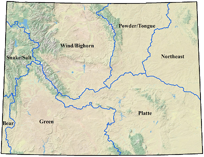
Below, you will find the Environmental and Recreational Water Use Reports for each of the seven basins.


Wyoming River Basins Map
Northeast River Basin (report in progress)
Powder/Tongue River Basin (report in progress)