Wyoming State Water Plan
Wyoming State Water Plan
Wyoming Water Development Office
6920 Yellowtail Rd
Cheyenne, WY 82002
Phone: 307-777-7626

Wyoming Water Development Office
6920 Yellowtail Rd
Cheyenne, WY 82002
Phone: 307-777-7626


| SUBJECT: |
Appendix J Storage Operation and Description HEALY RESERVOIR |
| PREPARED BY: | HKM Engineering Inc. |
| DATE: | March 2002 |
KEY STORAGE FACILITIES
| Reservoir: | HEALY RESERVOIR (or ENL OF 7289R) | 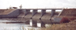 Healy Reservoir diversion dam | ||||||||||||||||||||||||||||||||||||||||||||||||||||||||||||||||||||||||||||||||||||||||||||||||||||||||||||||||||||||||||||||||||||||||||||||||||||||||||||||||||||||||||||||||||||||||||||||||||||||||||||||||||||||||||||||||||||||||||||||||||||||||||||||||||||||||||||||||||||||||||||||||||||||||||||||||||||||||||||||||||||||||||||||||||||||||||||||||||||||||||||||||||||||||||||||
| Date: | 27 Feb.2001 | |||||||||||||||||||||||||||||||||||||||||||||||||||||||||||||||||||||||||||||||||||||||||||||||||||||||||||||||||||||||||||||||||||||||||||||||||||||||||||||||||||||||||||||||||||||||||||||||||||||||||||||||||||||||||||||||||||||||||||||||||||||||||||||||||||||||||||||||||||||||||||||||||||||||||||||||||||||||||||||||||||||||||||||||||||||||||||||||||||||||||||||||||||||||||||||||
| Location: | NWSW 3,T51N,R81W | |||||||||||||||||||||||||||||||||||||||||||||||||||||||||||||||||||||||||||||||||||||||||||||||||||||||||||||||||||||||||||||||||||||||||||||||||||||||||||||||||||||||||||||||||||||||||||||||||||||||||||||||||||||||||||||||||||||||||||||||||||||||||||||||||||||||||||||||||||||||||||||||||||||||||||||||||||||||||||||||||||||||||||||||||||||||||||||||||||||||||||||||||||||||||||||||
| Owner: | Lake DeSmet Energy Co. | 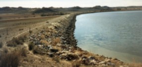 Healy Reservoir dam | ||||||||||||||||||||||||||||||||||||||||||||||||||||||||||||||||||||||||||||||||||||||||||||||||||||||||||||||||||||||||||||||||||||||||||||||||||||||||||||||||||||||||||||||||||||||||||||||||||||||||||||||||||||||||||||||||||||||||||||||||||||||||||||||||||||||||||||||||||||||||||||||||||||||||||||||||||||||||||||||||||||||||||||||||||||||||||||||||||||||||||||||||||||||||||||||
| Year of Construction: | 1975 | |||||||||||||||||||||||||||||||||||||||||||||||||||||||||||||||||||||||||||||||||||||||||||||||||||||||||||||||||||||||||||||||||||||||||||||||||||||||||||||||||||||||||||||||||||||||||||||||||||||||||||||||||||||||||||||||||||||||||||||||||||||||||||||||||||||||||||||||||||||||||||||||||||||||||||||||||||||||||||||||||||||||||||||||||||||||||||||||||||||||||||||||||||||||||||||||
| Total Storage: | 6500 acre-feet | |||||||||||||||||||||||||||||||||||||||||||||||||||||||||||||||||||||||||||||||||||||||||||||||||||||||||||||||||||||||||||||||||||||||||||||||||||||||||||||||||||||||||||||||||||||||||||||||||||||||||||||||||||||||||||||||||||||||||||||||||||||||||||||||||||||||||||||||||||||||||||||||||||||||||||||||||||||||||||||||||||||||||||||||||||||||||||||||||||||||||||||||||||||||||||||||
| Active Storage: | 5140 acre-feet | |||||||||||||||||||||||||||||||||||||||||||||||||||||||||||||||||||||||||||||||||||||||||||||||||||||||||||||||||||||||||||||||||||||||||||||||||||||||||||||||||||||||||||||||||||||||||||||||||||||||||||||||||||||||||||||||||||||||||||||||||||||||||||||||||||||||||||||||||||||||||||||||||||||||||||||||||||||||||||||||||||||||||||||||||||||||||||||||||||||||||||||||||||||||||||||||
| Area/Capacity Data: | (Source: Undated table on file with State Engineer's Office, Water Div. II) | |||||||||||||||||||||||||||||||||||||||||||||||||||||||||||||||||||||||||||||||||||||||||||||||||||||||||||||||||||||||||||||||||||||||||||||||||||||||||||||||||||||||||||||||||||||||||||||||||||||||||||||||||||||||||||||||||||||||||||||||||||||||||||||||||||||||||||||||||||||||||||||||||||||||||||||||||||||||||||||||||||||||||||||||||||||||||||||||||||||||||||||||||||||||||||||||
| ||||||||||||||||||||||||||||||||||||||||||||||||||||||||||||||||||||||||||||||||||||||||||||||||||||||||||||||||||||||||||||||||||||||||||||||||||||||||||||||||||||||||||||||||||||||||||||||||||||||||||||||||||||||||||||||||||||||||||||||||||||||||||||||||||||||||||||||||||||||||||||||||||||||||||||||||||||||||||||||||||||||||||||||||||||||||||||||||||||||||||||||||||||||||||||||||
| Dam Construction Type: | Earth Fill | |||||||||||||||||||||||||||||||||||||||||||||||||||||||||||||||||||||||||||||||||||||||||||||||||||||||||||||||||||||||||||||||||||||||||||||||||||||||||||||||||||||||||||||||||||||||||||||||||||||||||||||||||||||||||||||||||||||||||||||||||||||||||||||||||||||||||||||||||||||||||||||||||||||||||||||||||||||||||||||||||||||||||||||||||||||||||||||||||||||||||||||||||||||||||||||||
| Outlet: | Healy Reservoir has no gravity-fed outlet. It uses several electric pumps to lift water through a pipeline with a capacity of 200 cfs to Lake DeSmet and another, smaller pipeline with a capacity of 30 cfs to Clear Creek. | |||||||||||||||||||||||||||||||||||||||||||||||||||||||||||||||||||||||||||||||||||||||||||||||||||||||||||||||||||||||||||||||||||||||||||||||||||||||||||||||||||||||||||||||||||||||||||||||||||||||||||||||||||||||||||||||||||||||||||||||||||||||||||||||||||||||||||||||||||||||||||||||||||||||||||||||||||||||||||||||||||||||||||||||||||||||||||||||||||||||||||||||||||||||||||||||
| End-of-Month Storage Records: | Yes | |||||||||||||||||||||||||||||||||||||||||||||||||||||||||||||||||||||||||||||||||||||||||||||||||||||||||||||||||||||||||||||||||||||||||||||||||||||||||||||||||||||||||||||||||||||||||||||||||||||||||||||||||||||||||||||||||||||||||||||||||||||||||||||||||||||||||||||||||||||||||||||||||||||||||||||||||||||||||||||||||||||||||||||||||||||||||||||||||||||||||||||||||||||||||||||||
| Water Rights: | (Source: Tabulation of Adjudicated Surface Water Rights of the State of Wyoming, Water Division Number Two, Oct. 1999.) | |||||||||||||||||||||||||||||||||||||||||||||||||||||||||||||||||||||||||||||||||||||||||||||||||||||||||||||||||||||||||||||||||||||||||||||||||||||||||||||||||||||||||||||||||||||||||||||||||||||||||||||||||||||||||||||||||||||||||||||||||||||||||||||||||||||||||||||||||||||||||||||||||||||||||||||||||||||||||||||||||||||||||||||||||||||||||||||||||||||||||||||||||||||||||||||||
| ||||||||||||||||||||||||||||||||||||||||||||||||||||||||||||||||||||||||||||||||||||||||||||||||||||||||||||||||||||||||||||||||||||||||||||||||||||||||||||||||||||||||||||||||||||||||||||||||||||||||||||||||||||||||||||||||||||||||||||||||||||||||||||||||||||||||||||||||||||||||||||||||||||||||||||||||||||||||||||||||||||||||||||||||||||||||||||||||||||||||||||||||||||||||||||||||
| Note: As much as 36,824 af of permit 7289R is appropriated for Lake DeSmet; 5,140 af remain in Healy. Another 2,190 af from permit 7290R are reserved for the use of irrigators downstream of the reservoir on Clear Creek. The remainder of the second permit, 11,545 af, has been transferred to Lake DeSmet. | ||||||||||||||||||||||||||||||||||||||||||||||||||||||||||||||||||||||||||||||||||||||||||||||||||||||||||||||||||||||||||||||||||||||||||||||||||||||||||||||||||||||||||||||||||||||||||||||||||||||||||||||||||||||||||||||||||||||||||||||||||||||||||||||||||||||||||||||||||||||||||||||||||||||||||||||||||||||||||||||||||||||||||||||||||||||||||||||||||||||||||||||||||||||||||||||||
| Designated Use: | Industrial use, stock watering, and irrigation | |||||||||||||||||||||||||||||||||||||||||||||||||||||||||||||||||||||||||||||||||||||||||||||||||||||||||||||||||||||||||||||||||||||||||||||||||||||||||||||||||||||||||||||||||||||||||||||||||||||||||||||||||||||||||||||||||||||||||||||||||||||||||||||||||||||||||||||||||||||||||||||||||||||||||||||||||||||||||||||||||||||||||||||||||||||||||||||||||||||||||||||||||||||||||||||||
| Recreational Use: | Fishing | |||||||||||||||||||||||||||||||||||||||||||||||||||||||||||||||||||||||||||||||||||||||||||||||||||||||||||||||||||||||||||||||||||||||||||||||||||||||||||||||||||||||||||||||||||||||||||||||||||||||||||||||||||||||||||||||||||||||||||||||||||||||||||||||||||||||||||||||||||||||||||||||||||||||||||||||||||||||||||||||||||||||||||||||||||||||||||||||||||||||||||||||||||||||||||||||
| Associated Irrigation Diversions: | (Source: Carmine LoGuidice, Div. II water commissioner/hydrographer) | |||||||||||||||||||||||||||||||||||||||||||||||||||||||||||||||||||||||||||||||||||||||||||||||||||||||||||||||||||||||||||||||||||||||||||||||||||||||||||||||||||||||||||||||||||||||||||||||||||||||||||||||||||||||||||||||||||||||||||||||||||||||||||||||||||||||||||||||||||||||||||||||||||||||||||||||||||||||||||||||||||||||||||||||||||||||||||||||||||||||||||||||||||||||||||||||
| ||||||||||||||||||||||||||||||||||||||||||||||||||||||||||||||||||||||||||||||||||||||||||||||||||||||||||||||||||||||||||||||||||||||||||||||||||||||||||||||||||||||||||||||||||||||||||||||||||||||||||||||||||||||||||||||||||||||||||||||||||||||||||||||||||||||||||||||||||||||||||||||||||||||||||||||||||||||||||||||||||||||||||||||||||||||||||||||||||||||||||||||||||||||||||||||||
| Associated Industrial Diversions: | Though DeSmet (through Healy rights) stores water for industrial use, none of it is being appropriated. | |||||||||||||||||||||||||||||||||||||||||||||||||||||||||||||||||||||||||||||||||||||||||||||||||||||||||||||||||||||||||||||||||||||||||||||||||||||||||||||||||||||||||||||||||||||||||||||||||||||||||||||||||||||||||||||||||||||||||||||||||||||||||||||||||||||||||||||||||||||||||||||||||||||||||||||||||||||||||||||||||||||||||||||||||||||||||||||||||||||||||||||||||||||||||||||||
| Operational Discussion: | Healy was constructed as a feeder reservoir for Lake DeSmet, a way of diverting Clear Creek water into DeSmet to supplement the Piney Creek water in anticipation of industrial consumption. As of Feb. 2001, DeSmet has been turned over to three county governments (Sheridan, Johnson, and Campbell). | |||||||||||||||||||||||||||||||||||||||||||||||||||||||||||||||||||||||||||||||||||||||||||||||||||||||||||||||||||||||||||||||||||||||||||||||||||||||||||||||||||||||||||||||||||||||||||||||||||||||||||||||||||||||||||||||||||||||||||||||||||||||||||||||||||||||||||||||||||||||||||||||||||||||||||||||||||||||||||||||||||||||||||||||||||||||||||||||||||||||||||||||||||||||||||||||
| Healy's off-channel status on Clear Creek means storage is accomplished by raising the head (closing headgates) in Healy Diversion Dam. Similarly, downstream releases are accomplished by lowering the head at the dam to release flows through the intake pipe. Much of the reservoir's storage lies lower than the level of the intake/outlet pipe. As a result, operators must pump to release water below the level of the pipe. | ||||||||||||||||||||||||||||||||||||||||||||||||||||||||||||||||||||||||||||||||||||||||||||||||||||||||||||||||||||||||||||||||||||||||||||||||||||||||||||||||||||||||||||||||||||||||||||||||||||||||||||||||||||||||||||||||||||||||||||||||||||||||||||||||||||||||||||||||||||||||||||||||||||||||||||||||||||||||||||||||||||||||||||||||||||||||||||||||||||||||||||||||||||||||||||||||
| Lack of demand for Healy's water and the cost of pumping has kept the owners from exercising their pumps more than rarely to satisfy obligations in Lake DeSmet and to downstream Clear Creek users. | ||||||||||||||||||||||||||||||||||||||||||||||||||||||||||||||||||||||||||||||||||||||||||||||||||||||||||||||||||||||||||||||||||||||||||||||||||||||||||||||||||||||||||||||||||||||||||||||||||||||||||||||||||||||||||||||||||||||||||||||||||||||||||||||||||||||||||||||||||||||||||||||||||||||||||||||||||||||||||||||||||||||||||||||||||||||||||||||||||||||||||||||||||||||||||||||||
| Releases to irrigators are based on their requests. | ||||||||||||||||||||||||||||||||||||||||||||||||||||||||||||||||||||||||||||||||||||||||||||||||||||||||||||||||||||||||||||||||||||||||||||||||||||||||||||||||||||||||||||||||||||||||||||||||||||||||||||||||||||||||||||||||||||||||||||||||||||||||||||||||||||||||||||||||||||||||||||||||||||||||||||||||||||||||||||||||||||||||||||||||||||||||||||||||||||||||||||||||||||||||||||||||
| The Clear Creek Diversion Dam (adjoining Healy Reservoir) is also required to allow at least 10 cfs to pass down Clear Creek from Oct. 15 . April 15. | ||||||||||||||||||||||||||||||||||||||||||||||||||||||||||||||||||||||||||||||||||||||||||||||||||||||||||||||||||||||||||||||||||||||||||||||||||||||||||||||||||||||||||||||||||||||||||||||||||||||||||||||||||||||||||||||||||||||||||||||||||||||||||||||||||||||||||||||||||||||||||||||||||||||||||||||||||||||||||||||||||||||||||||||||||||||||||||||||||||||||||||||||||||||||||||||||
| References: | Carmine LoGuidice, water commissioner, State Engineer's Office Water Div. 2, 20 Feb. 2001. | |||||||||||||||||||||||||||||||||||||||||||||||||||||||||||||||||||||||||||||||||||||||||||||||||||||||||||||||||||||||||||||||||||||||||||||||||||||||||||||||||||||||||||||||||||||||||||||||||||||||||||||||||||||||||||||||||||||||||||||||||||||||||||||||||||||||||||||||||||||||||||||||||||||||||||||||||||||||||||||||||||||||||||||||||||||||||||||||||||||||||||||||||||||||||||||||
| Healy Area-Capacity Table, from permit application, State Engineer's Office. | ||||||||||||||||||||||||||||||||||||||||||||||||||||||||||||||||||||||||||||||||||||||||||||||||||||||||||||||||||||||||||||||||||||||||||||||||||||||||||||||||||||||||||||||||||||||||||||||||||||||||||||||||||||||||||||||||||||||||||||||||||||||||||||||||||||||||||||||||||||||||||||||||||||||||||||||||||||||||||||||||||||||||||||||||||||||||||||||||||||||||||||||||||||||||||||||||
| Active Dams, State Engineer's Office Safety of Dams Engineering Div. Database, transmitted by Larry Stockdale, Safety of Dams engineering consultant, 16 Feb. 2001. | ||||||||||||||||||||||||||||||||||||||||||||||||||||||||||||||||||||||||||||||||||||||||||||||||||||||||||||||||||||||||||||||||||||||||||||||||||||||||||||||||||||||||||||||||||||||||||||||||||||||||||||||||||||||||||||||||||||||||||||||||||||||||||||||||||||||||||||||||||||||||||||||||||||||||||||||||||||||||||||||||||||||||||||||||||||||||||||||||||||||||||||||||||||||||||||||||
| Tabulation of Adjudicated Surface Water Rights of the State of Wyoming, Water Division Number Two, Oct. 1999, database transmitted by Rebecca Mathisen, SEO Technical Services Division administrator, 8 Sept. 2000. | ||||||||||||||||||||||||||||||||||||||||||||||||||||||||||||||||||||||||||||||||||||||||||||||||||||||||||||||||||||||||||||||||||||||||||||||||||||||||||||||||||||||||||||||||||||||||||||||||||||||||||||||||||||||||||||||||||||||||||||||||||||||||||||||||||||||||||||||||||||||||||||||||||||||||||||||||||||||||||||||||||||||||||||||||||||||||||||||||||||||||||||||||||||||||||||||||
Net Evaporation Loss from Healy Reservoir:
Healy Reservoir End-of-Month
Elevations of Water Surface
| Jan | Feb | Mar | Apr | May | Jun | Jul | Aug | Sep | Oct | Nov | Dec | ||
| 1970 | 1971 | 1972 | 1973 | 1974 | 1975 | 1976 | 1977 | 1978 | 1979 | 1980 | 4384.7 | 4384.45 | 4384.35 | 4385.8 | 4385.4 | 4387 | 4386.45 | 4384.25 | 4383 | 4384.2 | 4385.6 | 4380.8 | 1981 | 4375.9 | 4370.9 | 4371 | 4372.6 | 4370.25 | 4379.1 | 4382.6 | 4381.65 | 4378.6 | 4385.9 | 4382.1 | 4380.35 | 1982 | 4375.3 | 4372.45 | 4378.8 | 4379.75 | 4385.3 | 4386 | 4385.5 | 4381.5 | 4380.3 | 4380.1 | 4380 | 4379.85 | 1983 | 4379.8 | 4379.7 | 4379.7 | 4379.65 | 4379.65 | 4384.1 | 4384.9 | 4384.75 | 4382.4 | 4382.1 | 4381.9 | 4381.7 | 1984 | 4381.5 | 4381.45 | 4381.35 | 4381 | 4376.6 | 4374 | 4368.2 | 4364.8 | 4367.85 | 4379.8 | 4383 | 1985 | 4384.35 | 4385.4 | 4385.9 | 4385.6 | 4385.7 | 4386 | 4385.7 | 4380.4 | 4376.4 | 4377.8 | 4378.35 | 4378.3 | 1986 | 4378.2 | 4378.2 | 4378.1 | 4378.05 | 4386.15 | 4386.65 | 4386.85 | 4386.05 | 4385.6 | 4384.55 | 4384.5 | 4384.45 | 1987 | 4384.35 | 4384.25 | 4384.25 | 4384.05 | 4384.85 | 4385.15 | 4380.5 | 4375.1 | 4370.3 | 4369.9 | 4370.9 | 4374.55 | 1988 | 4378 | 4379 | 4380.35 | 4384.55 | 4387 | 4386.65 | 4387.25 | 4386.15 | 4384.65 | 4384.2 | 4384 | 1989 | 4383.8 | 4383.75 | 4383.35 | 4383.25 | 4383.75 | 4387.4 | 4385 | 4383.35 | 4383.45 | 4383.15 | 4383 | 1990 | 4382.7 | 4382.6 | 4382.55 | 4385.35 | 4385.2 | 4381.2 | 4376.3 | 4375.18 | 1991 | 4380.1 | 4379.96 | 4380.1 | 4380.72 | 4384.6 | 4386.53 | 4387.19 | 4386.13 | 4385.17 | 4384.82 | 4384.7 | 1992 | 4384.41 | 4384.65 | 4386.14 | 4386.28 | 4386.08 | 4385.95 | 4385.15 | 1993 | 4384.95 | 4385.39 | 4385.47 | 4383.5 | 4378.5 | 4375.1 | 4380.95 | 4381.8 | 1994 | 4381.7 | 4381.6 | 4386.65 | 4386.3 | 4381.5 | 4381.25 | 1995 | 1996 | 1997 | 1998 | 1999 | Historical Ave. Elevation | 4380.84 | 4380.18 | 4381.24 | 4381.95 | 4383.32 | 4384.56 | 4383.93 | 4382.42 | 4379.63 | 4380.10 | 4381.36 | 4381.47 | Corresponding Area (acres) | 193 | 193 | 200 | 200 | 213 | 219 | 213 | 206 | 187 | 193 | 200 | 200 |
| Jan | Feb | Mar | Apr | May | Jun | Jul | Aug | Sep | Oct | Nov | Dec | Calculations: | |
| Monthly Lewis Evap. (inches) | 1.296 | 1.2 | 1.872 | 3.84 | 5.52 | 6.288 | 8.208 | 7.488 | 5.52 | 3.648 | 1.872 | 1.248 | |
| Monthly Precipitation (inches) | 0.75 | 0.75 | 0.75 | 1.75 | 2.75 | 2.25 | 1.25 | 0.75 | 1.75 | 1.25 | 0.75 | 0.75 | |
| Net Evaporation (inches) | 0.546 | 0.45 | 1.122 | 2.09 | 2.77 | 4.038 | 6.958 | 6.738 | 3.77 | 2.398 | 1.122 | 0.498 | TOTAL |
| Total Net Evaporation (acre-feet) | 9 | 7 | 19 | 35 | 49 | 74 | 124 | 116 | 59 | 39 | 19 | 8 | 556 |