Wyoming State Water Plan
Wyoming State Water Plan
Wyoming Water Development Office
6920 Yellowtail Rd
Cheyenne, WY 82002
Phone: 307-777-7626

Wyoming Water Development Office
6920 Yellowtail Rd
Cheyenne, WY 82002
Phone: 307-777-7626


| SUBJECT: |
Appendix J Storage Operation and Description TRACT 37 |
| PREPARED BY: | HKM Engineering Inc. |
| DATE: | March 2002 |
KEY STORAGE FACILITIES
| Reservoir: | TRACT 37 | ||||||||||||||||||||||||||||||||||||||||||||||||||||||||||||||||||||||||||
| Date: | 26 Feb. 2001 | ||||||||||||||||||||||||||||||||||||||||||||||||||||||||||||||||||||||||||
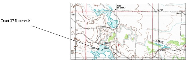
| Location: | SENW 31,T57N,R66W | ||||||||||||||||||||||||||||||||||||||||||||||||||||||||||||||||||||||||||
| Owner: | F. A. BUSH & WYO BOARD OF LAND COMM. | ||||||||||||||||||||||||||||||||||||||||||||||||||||||||||||||||||||||||||
| Year of Construction: | 1976 | 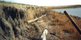 | |||||||||||||||||||||||||||||||||||||||||||||||||||||||||||||||||||||||||
| Total Storage: | 2,454 acre-feet | ||||||||||||||||||||||||||||||||||||||||||||||||||||||||||||||||||||||||||
| Active Storage: | 1,236.3 acre-feet | ||||||||||||||||||||||||||||||||||||||||||||||||||||||||||||||||||||||||||
| Dead Storage: | 183.4 acre-feet | ||||||||||||||||||||||||||||||||||||||||||||||||||||||||||||||||||||||||||
| Area/Capacity Data: | (Source: Map accompanying permit for Tract 37 Reservoir, on file in SEO Safety of Dams office.) | ||||||||||||||||||||||||||||||||||||||||||||||||||||||||||||||||||||||||||
| |||||||||||||||||||||||||||||||||||||||||||||||||||||||||||||||||||||||||||
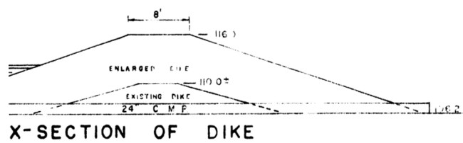
| Dam Construction Type: | Earth Fill | ||||||||||||||||||||||||||||||||||||||||||||||||||||||||||||||||||||||||||
| Outlet: | Twenty-four-inch corrugated metal pipe (method of controlling flow not available) | ||||||||||||||||||||||||||||||||||||||||||||||||||||||||||||||||||||||||||
| Spillway: | Principal: Sixty-six-inch corrugated metal pipe | ||||||||||||||||||||||||||||||||||||||||||||||||||||||||||||||||||||||||||
| End-of-Month Storage Records: | No | ||||||||||||||||||||||||||||||||||||||||||||||||||||||||||||||||||||||||||
| Water Rights: | (Source: Tabulation of Adjudicated Surface Water Rights of the State of Wyoming, Water Division Number Two, Oct. 1999) | ||||||||||||||||||||||||||||||||||||||||||||||||||||||||||||||||||||||||||
| |||||||||||||||||||||||||||||||||||||||||||||||||||||||||||||||||||||||||||
| Designated Use: | Irrigation, flood control, and stock | ||||||||||||||||||||||||||||||||||||||||||||||||||||||||||||||||||||||||||
| Associated Irrigation Diversions: | Information not available. | ||||||||||||||||||||||||||||||||||||||||||||||||||||||||||||||||||||||||||
| References: | Map to Accompany Application for Permit, Tract 37 Reservoir, F.A. Bush, Inc., 1974. | ||||||||||||||||||||||||||||||||||||||||||||||||||||||||||||||||||||||||||
Tract 37 Dam cross section (Source: Map to accompany permit for Tract 37 Reservoir, on file with SEO Safety of Dams office, Cheyenne.):
Net evaporative storage loss for Tract 37 Reservoir:
| Lewis Annual Evaporation (in.) | 41 |
| Total Storage (acre-feet) | 2,454 |
| Jan | Feb | Mar | Apr | May | Jun | Jul | Aug | Sep | Oct | Nov | Dec | ||
| Average percent of storage | 52.1 | 55.7 | 63.8 | 67.0 | 73.3 | 74.9 | 73.5 | 71.3 | 69.2 | 51.6 | 51.3 | 51.5 | |
| Generated storage (acre-feet) | 1278 | 1366 | 1565 | 1643 | 1800 | 1837 | 1803 | 1750 | 1699 | 1265 | 1259 | 1263 | |
| Corresponding area (acres) | 236.7 | 241.6 | 252.7 | 257.0 | 265.8 | 267.8 | 266.0 | 263.0 | 260.2 | 236.0 | 235.6 | 235.8 | |
| Calculations: | |||||||||||||
| Monthly Lewis Evap. (inches) | 1.107 | 1.025 | 1.599 | 3.28 | 4.715 | 5.371 | 7.011 | 6.396 | 4.715 | 3.116 | 1.599 | 1.066 | |
| Monthly Precipitation (inches) | 0.25 | 0.25 | 0.75 | 1.25 | 2.75 | 2.75 | 1.75 | 1.25 | 1.25 | 1.25 | 0.75 | 0.75 | |
| Net Evaporation (inches) | 0.857 | 0.775 | 0.849 | 2.03 | 1.965 | 2.621 | 5.261 | 5.146 | 3.465 | 1.866 | 0.849 | 0.316 | TOTAL |
| Total Net Evaporation (acre-feet) | 17 | 16 | 18 | 43 | 44 | 58 | 117 | 113 | 75 | 37 | 17 | 6 | 560 |