Wyoming State Water Plan
Wyoming State Water Plan
Wyoming Water Development Office
6920 Yellowtail Rd
Cheyenne, WY 82002
Phone: 307-777-7626

Wyoming Water Development Office
6920 Yellowtail Rd
Cheyenne, WY 82002
Phone: 307-777-7626


| SUBJECT: |
Appendix I Woodruff Narrows Reservoir |
| PREPARED BY: | Bear River Basin Planning Team |
| DATE: | July 20, 2000 |
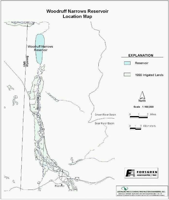
| Location: Section 32, Township 18N, Range 120W. Located on the main stream of the Bear River, approximately 5.6 miles upstream from the Wyoming-Utah State line. See location map. |
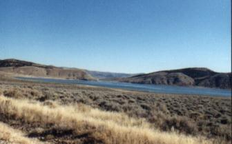 Woodruff Narrows Reservoir |
 Plain View-Woodruff Narrows Dam |
Year of construction: 1959
Enlargement History: 1975 Enlargement
Ownership: Woodruff Narrows Reservoir Company.
Contact Blair Francis, president (801-793-4243)
Total Storage: 57,300 acre-feet
Active Storage: 55,700 acre-feet Dead Storage: 1600 acre-feet |
Area/Capacity Data:
| Woodruff Narrows Reservoir Capacity Table | ||
| Elevation | Area (acres) |
Cumulative Capacity (acre-feet) |
| 6397 | 0 | 0 |
| 6400 | 8.8 | 17.6 |
| 6404 | 312 | 980 |
| 6410 | 417.4 | 1600 |
| 6411.7 | 512.9 | 3135 |
| 6415 | 714 | 6195 |
| 6420 | 906 | 10,245 |
| 6425 | 1,114 | 15,245 |
| 6430 | 1,380 | 21,530 |
| 6439.4 | 1,620 | 28,100 |
| 6445 | 1,796 | 37,700 |
| 6450 | 2,086 | 47,405 |
| 6454.5 | 2,312 | 57,300 |
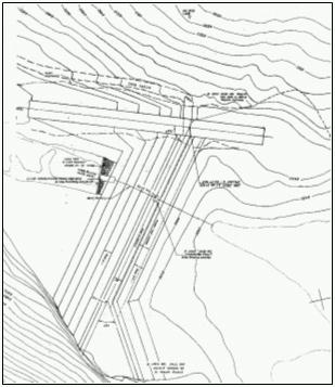
Dam Construction Type: Earth-fill with rock face
| Outlet: | Originally two concrete conduits, each 5-ft x 6-ft. Retrofitted with two 4.7-ft x 5.8-ft O.D. steel ellipse pipes grouted into the original concrete conduits. | 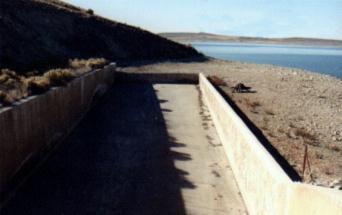 Woodruff Narrows Spillway |
| Spillway: | Concrete chute spillway, 40-ft. wide, along the right abutment. Capacity = 6000 cfs |
End-of-Month Storage Records: End-of-month storage records were maintained until 1997, at which time the gage was removed. A table of these records is attached to this memo.
Water Rights: The table below represents the five permits that have been issued to either the Woodruff Narrows Reservoir Company of the State of Utah.
| Woodruff Narrows Permitted Storage Rights | |||
|---|---|---|---|
| Permit No. | Priority | Volume (acre-feet) |
Comments |
| 1958 Compact Rights | |||
| 6556 U&WR | 8-3-1959 | 1,600 | Wy – Inactive Storage |
| 6556 UR | 8-3-1959 | 15,240 | Ut – Storage |
| 8060 WR | 8-3-1959 | 3,000 | Wy – Storage |
| 6556 UR | 8-3-1959 | 3,560 | Ut – Carryover |
| 6556 WR | 8-3-1959 | 700 | Wy – Carryover |
| 6556 U&WR | 8-3-1959 | 4,000 | Fish & Wildlife |
| 8060R | 7-25-1975 | 250 | Wy – Storage |
| 1980 Amended Compact Rights | |||
| 8060R | 7-25-1975 | 2,960 | Wy - Storage |
| 8060R | 7-25-1975 | 18,000 | Ut - Storage |
| 8060R | 7-25-1975 | 985.09 | Wy - Carryover |
| 8060R | 7-25-1975 | 2,481.91 | Ut - Carryover |
| 8061R | 8-6-1979 | 768.91 | Wy - Carryover |
| 8061R | 8-6-1979 | 3754.09 | Ut - Carryover |
| TOTALS | 43,450 | ||
Designated Use: Irrigation and Stock
Recreational Use: Woodruff Narrows Reservoir is a popular fishing and boating location. In the winter it is a popular ice fishing location.
Associated Irrigation Diversions:There are presently 48,153 shares in the Woodruff Narrows Reservoir. Each share corresponds to one acre of irrigated ground. 39,967 shares (83%) are in Utah and 8,186 shares (17%) are in Wyoming.
Utah irrigators receive Woodruff Narrows water from the following ditches:
Francis Lee, Bear River Canal, Neville, Booth, Rees Land & Livestock, Crawford-Thompson, Randolph Woodruff, Big Creek Pumping Co. (pump out of Randolph Woodruff ditch), Dykens, Randolph Sage Creek, McMinn, Enberg, B.Q. West, Adam Pump).
Wyoming irrigators receive Woodruff Narrows water from the Pixley Canal, BQ West, Weston Pumps, and Johnson Pumps.
Associated Industrial Diversions:Water pumped out of Woodruff Narrows Reservoir and consumed by Chevron USA at their Whitney Canyon/Carter Creek Facility is purchased from Woodruff Narrows Reservoir Company. During the months when the reservoir is storing, the water pumped counts against the allowed reservoir storage in Woodruff Narrows.
Operational Discussion: Filling of Woodruff Narrows and Sulphur Creek Reservoir is handled on a proportional basis based on storage allocation (not strictly priority). Woodruff Narrow’s original Compact allocation is 76.4% of the combined and Sulphur Creek’s original Compact allocations is 23.6% of the combined.
The maximum amount of storage that can take place in one year is 18,400 acre- feet under the Original Compact and 20,960 acre-feet under the Amended Compact. Wyoming has allowed Woodruff Narrows, Broadbent, and Sulphur Creek Reservoirs to temporarily store a portion of their unconstructed original compact allocated storage when Bear Lake levels dropped below elevation 5911 in the early 1990’s. Releases of at least 10 cfs will be made per agreements between PacifiCorp and Utah Division of Wildlife Resources.
It should be noted that the Wyoming irrigators often have difficulty receiving their allotment of Woodruff Narrows storage. This problem is due to conveyance losses during dry periods when storage is needed, the inability to distinguish and regulate Wyoming storage vs. direct flow through the Lower Utah reach of the river, and the operational practices of the reservoir.
Resources:
1) Water Right Permit 8060R Special Limitations
2) Sue Lowry, Summary of 1958 Bear River Compact Allocations, Bear River Basin, Wyoming; October 1990;
3) Sue Lowry, Policy Definition Regarding the Storage of Water in Woodruff Narrows and Sulphur Creek Reservoirs; October 1990
4) Bear River Compact as Amended, Amended Compact Unanimously Approved December 22, 1978 by Duly Appointed Commissioners from those states of Idaho, Utah, and Wyoming, Ratified by the Legislatures of all 3 states in 1979, Congressional Consent Public Law 96- 189 February 8, 1980.
BEAR RIVER STORAGE (Wyoming Section - Upper Division)
END-OF-MONTH STORAGE RECORDS
WOODRUFF NARROWS RESERVOIR
| END OF MONTH STORAGE (acre-feet) | |||||||||||||
| YEAR | JANUARY | FEBRUARY | MARCH | APRIL | MAY | JUNE | JULY | AUGUST | SEPTEMBER | OCTOBER | NOVEMBER | DECEMBER | |
| 1970 | 20,270 | 22,890 | 25,800 | 29,180 | 32,350 | 30,080 | 19,000 | 11,600 | 11,520 | 13,000 | 15,670 | 17,550 | |
| 1971 | 28,410 | 28,120 | 29,930 | 29,370 | 31,530 | 31,200 | 28,260 | 20,180 | 14,700 | 15,780 | 19,720 | 23,520 | |
| 1972 | 28,260 | 28,560 | 28,860 | 29,370 | 31,690 | 23,640 | 17,550 | 12,410 | 11,000 | 18,510 | 24,710 | 27,550 | |
| 1973 | 24,260 | 27,370 | 28,410 | 31,200 | 30,630 | 23,890 | 16,810 | 14,370 | 18,390 | 13,690 | 17,550 | 19,600 | |
| 1974 | 21,320 | 18,390 | 29,000 | 30,850 | 32,700 | 27,020 | 16,370 | 15,000 | 12,900 | 23,520 | 28,120 | 25,500 | |
| 1975 | 18,760 | 21,180 | 27,690 | 28,710 | 30,410 | 31,530 | 28,710 | 27,690 | 21,320 | 13,000 | 14,260 | 16,600 | |
| 1976 | 27,970 | 28,260 | 29,000 | 29,000 | 30,230 | 12,490 | 5,840 | 4,920 | 1,570 | 22,310 | 26,320 | 27,830 | |
| 1977 | 3,070 | 4,060 | 5,500 | 10,370 | 14,590 | 2,440 | 2,040 | 1,230 | 970 | 1,910 | 2,400 | 2,630 | |
| 1978 | 4,180 | 5,640 | 13,270 | 27,370 | 30,630 | 29,930 | 18,000 | 16,600 | 16,370 | 1,510 | 2,040 | 2,770 | |
| 1979 | 17,130 | 18,130 | 22,310 | 28,560 | 21,880 | 7,320 | 5,500 | 6,050 | 5,640 | 15,890 | 16,120 | 16,710 | |
| 1980 | 12,570 | 16,490 | 21,180 | 20,060 | 19,960 | 15,570 | 7,790 | 5,300 | 4,790 | 6,260 | 7,240 | 8,440 | |
| 1981 | 16,660 | 20,160 | 24,490 | 47,620 | 47,420 | 45,560 | 21,950 | 17,540 | 15,780 | 6,440 | 10,450 | 13,580 | |
| 1982 | 23,200 | 26,400 | 32,500 | 55,930 | 59,820 | 60,470 | 52,230 | 47,230 | 58,200 | 17,990 | 17,870 | 20,570 | |
| 1983 | 35,700 | 36,300 | 45,460 | 59,790 | 63,180 | 61,600 | 58,660 | 58,880 | 58.880 | 56,850 | 43,000 | 36,000 | |
| 1984 | 55,040 | 57,530 | 51,920 | 49,980 | 61,140 | 55,940 | 44,690 | 47,840 | 55,260 | 52,360 | 46,640 | 50,630 | |
| 1985 | 57,750 | 57,750 | 57,980 | 60,470 | 55,040 | 30,010 | 18,590 | 17,210 | 18,230 | 57,750 | 57,750 | 57,750 | |
| 1986 | 35,650 | 54,130 | 59,790 | 60,240 | 62,500 | 57,750 | 56,400 | 49,120 | 48,480 | 25,340 | 28,300 | 30,530 | |
| 1987 | 57,980 | 57,980 | 57,530 | 59,560 | 58,660 | 33,430 | 23,080 | 22,800 | 22,380 | 55,720 | 57,980 | 57,980 | |
| 1988 | 28,470 | 33,430 | 39,640 | 57,980 | 57,530 | 22,800 | 16,440 | 14,390 | 12,870 | 22,240 | 24,630 | 26,590 | |
| 1989 | 8,060 | 8,540 | 20,160 | 32,580 | 27,450 | 6,840 | 3,560 | 3,200 | 3,620 | 11,660 | 10,950 | 9,350 | |
| 1990 | 7,330 | 9,350 | 16,660 | 23,220 | 21,800 | 7,490 | 5,400 | 4,480 | 4,360 | 4,540 | 5,460 | 5,960 | |
| 1991 | 8,060 | 9,570 | 11,600 | 17,000 | 31,300 | 34,500 | 25,100 | 24,400 | 24,400 | 4,860 | 5,840 | 6,530 | |
| 1992 | 36,800 | 40,300 | 51,100 | 50,600 | 42,800 | 9,800 | 6,920 | 5,370 | 4,580 | 27,200 | 31,000 | 34,000 | |
| 1993 | 7,410 | 9,680 | 21,400 | 26,600 | 49,600 | 3,000 | 26,840 | 25,790 | 24,560 | 4,070 | 4,280 | 5,220 | |
| 1994 | 35,100 | 36,580 | 45,000 | 56,550 | 49,940 | 17,600 | 9,350 | 8,660 | 7,220 | 28,060 | 30,390 | 32,900 | |
| 1995 | 13,500 | 16,600 | 28,520 | 24,760 | 24,800 | 48,070 | 59,490 | 54,180 | 43,110 | 8,540 | 9,130 | 11,400 | |
| 1996 | 44,000 | 46,800 | 54,600 | 59,900 | 60,800 | 51,200 | 37,510 | 34,800 | 28,800 | 42,880 | 43,650 | 43,000 | |
| 1997 | |||||||||||||
| 1998 | |||||||||||||
| AVERAGES | 25,071 | 27,414 | 32,567 | 38,401 | 40,014 | 28,929 | 23,410 | 21,157 | 20,367 | 21,181 | 22,277 | 23,359 | |
| Note: Gage was removed in 1997. | |||||||||||||