Wyoming State Water Plan
Wyoming State Water Plan
Wyoming Water Development Office
6920 Yellowtail Rd
Cheyenne, WY 82002
Phone: 307-777-7626

Wyoming Water Development Office
6920 Yellowtail Rd
Cheyenne, WY 82002
Phone: 307-777-7626


| SUBJECT: |
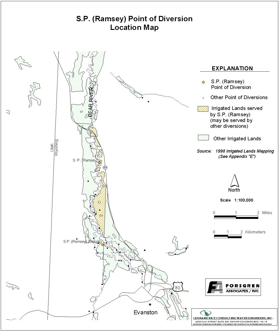
Appendix D Key Structures and Diversions S.P. (RAMSEY) DIVERSION (Also called Adin Brown) |
| PREPARED BY: | Bear River Basin Planning Team |
| DATE: | August 7, 2000 |
| Diversion Description: The headgate structure consists of a deteriorated concrete headwall, a 48-inch CMP culvert, and a slide gate. The actual river diversion is located approximately 2000 feet upstream of the gate. A dozer is typically used each year to dam the river. | 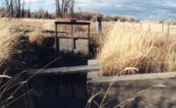 S.P. (Ramsey) Headgate |
|
Conveyance Description: Open channel canal, approximately 21,120 feet in length.1
Direct Flow Water Rights:2
| Priority Date | Permit Number |
Permitted Use | Permitted Acres |
Flow (CFS) |
Cumulative (CFS) |
Comments |
|---|---|---|---|---|---|---|
| -1878 | Terr | Irrigation | 67 | 0.95 | 0.95 | (Adin Brown) |
| 10-01-1880 | Terr | Irrigation | 20 | 0.28 | 1.23 | (Morris Bros Irr) |
| -1887 | Terr | Irrigation | 80 | 1.14 | 2.37 | (East) |
| 11-15-1900 | 599E | Irrigation | 38 | 0.54 | 2.91 | (Enl Adin Brown) |
| 11-15-1900 | 599E | Irrigation | 71 | 1.01 | 3.92 | (Enl Adin Brown) |
| 10-13-1916 | 3696E | Irrigation | 45 | 0.64 | 4.56 | (Enl Adin Brown) |
| 10-13-1916 | 3696E | Irrigation | 42 | 0.60 | 5.16 | (Enl Adin Brown) |
| 03-25-1920 | 16374E | Irrigation | 52 | 0.74 | 5.90 | (Neville) |
| 07-26-1920 | 4299E | Irrigation | 67 | 0.96 | 6.86 | (Enl Neville) |
| 08-16-1922 | 4317E | Irrigation | 4 | 0.06 | 6.92 | (Enl Neville) |
| 08-16-1922 | 4317E | Irrigation | 42 | 0.60 | 7.52 | (Enl Neville) |
| 09-25-1956 | 5868E | Irrigation | 114.50 | 1.63 | 9.15 | |
| 09-25-1956 | 2868E | Irrigation | 111.60 | 1.59 | 10.74 |
Associated Storage Rights:
| Reservoir | Shareholder | Volume (Acre-ft) |
Est. % of Shares Used this Diversion3 | Comments |
|---|---|---|---|---|
| Sulphur Creek | Sharon Ruffi | 55 | 100% | |
| Sulphur Creek | Delbert Barker | 110 | 100% | |
| Sulphur Creek | James Condos | 27 | 100% | |
| Sulphur Creek | Dennis Moon | 4 | 100% | |
| Sulphur Creek | Charles Nixon | 137 | 34% | |
| Sulphur Creek | Gilda Sims | 219 | 50% | |
| Sulphur Creek | Michael Sims | 40 | 50% |
Irrigation Practices: Flood Irrigated except for about 80 acres sprinkled. Sprinkled acreage is alfalfa.3
Estimated Diversion Efficiency:
Calculated Diversion Efficiency = Conveyance Efficiency X Application Efficiency:
Conveyance Efficiency: 60% Application Efficiency: 55% Overall Diversion Efficiency: 33% Conveyance efficiency is estimated by total length of main canal. Application efficiency for flood irrigation and sprinkler irrigation is estimated at 55% and 85% respectively.
Crop Types / Consumptive Use: Mostly meadow grasses. Approximately 80 acres is alfalfa.3
Return Flows: Return flow is primarily split between the Chapman Canal (approx. 50%) and the Bear River (approx. 50%).
The following return flow pattern was adopted for modeling in this study are as follows:
		Month
      (after initial Diversion)	 Percent of Return
		0			70%
		1			20%
		2			10%
		3			 0%
                                       100%
References:
Monthly Diversion Records
S.P. (Ramsey)
| YEAR | MAY | JUNE | JULY | AUGUST | SEPTEMBER | ||||||||||
|---|---|---|---|---|---|---|---|---|---|---|---|---|---|---|---|
| Total of Daily Ave for Month | Average CFS |
Monthly Total Ac-Ft |
Total of Daily Ave for Month | Average CFS |
Monthly Total Ac-Ft |
Total of Daily Ave for Month | Average CFS |
Monthly Total Ac-Ft |
Total of Daily Ave for Month | Average CFS |
Monthly Total Ac-Ft |
Total of Daily Ave for Month | Average CFS |
Monthly Total Ac-Ft | |
| *1970 | |||||||||||||||
| 1971 | 0 | 0.0 | 0.0 | 684 | 22.8 | 1356.7 | 591 | 19.1 | 1172.2 | 169 | 5.5 | 335.2 | 51 | 1.7 | 101.2 |
| 1972 | 281 | 9.1 | 557.4 | 423 | 14.1 | 839.0 | 403 | 13.0 | 799.3 | 323 | 10.4 | 640.7 | 238 | 7.9 | 472.1 |
| 1973 | 67 | 2.2 | 132.9 | 557 | 18.6 | 1104.8 | 337 | 10.9 | 668.4 | 181 | 5.8 | 359.0 | 99 | 3.3 | 196.4 |
| 1974 | 233 | 7.5 | 462.1 | 530 | 17.7 | 1051.2 | 221 | 7.1 | 438.3 | 246 | 7.9 | 487.9 | 226 | 7.5 | 448.3 |
| 1975 | 46 | 1.5 | 91.2 | 521 | 17.4 | 1033.4 | 391 | 12.6 | 775.5 | 237 | 7.6 | 470.1 | 72 | 2.4 | 142.8 |
| 1976 | 110 | 3.5 | 218.2 | 281 | 9.4 | 557.4 | 200 | 6.5 | 396.7 | 214 | 6.9 | 424.5 | 72 | 2.4 | 142.8 |
| 1977 | 185 | 6.0 | 366.9 | 220 | 7.3 | 436.4 | 139 | 4.5 | 275.7 | 100 | 3.2 | 198.3 | 93 | 3.1 | 184.5 |
| 1978 | 388 | 12.5 | 769.6 | 918 | 30.6 | 1820.8 | 487 | 15.7 | 966.0 | 201 | 6.5 | 398.7 | 187 | 6.2 | 370.9 |
| 1979 | 658 | 21.2 | 1305.1 | 567 | 18.9 | 1124.6 | 167 | 5.4 | 331.2 | 157 | 5.1 | 311.4 | 18 | 0.6 | 35.7 |
| 1980 | 0 | 0.0 | 0.0 | 691 | 23.0 | 1370.6 | 398 | 12.8 | 789.4 | 190 | 6.1 | 376.9 | 236 | 7.9 | 468.1 |
| 1981 | 573 | 18.5 | 1136.5 | 641 | 21.4 | 1271.4 | 244 | 7.9 | 484.0 | 206 | 6.6 | 408.6 | 191 | 6.4 | 378.8 |
| 1982 | 63 | 2.0 | 125.0 | 766 | 25.5 | 1519.3 | 582 | 18.8 | 1154.4 | 188 | 6.1 | 372.9 | 236 | 7.9 | 468.1 |
| 1983 | 93 | 3.0 | 184.5 | 119 | 4.0 | 236.0 | 437 | 14.1 | 866.8 | 263 | 8.5 | 521.7 | 49 | 1.6 | 97.2 |
| 1984 | 70 | 2.3 | 138.8 | 409 | 13.6 | 811.2 | 389 | 12.5 | 771.6 | 30 | 1.0 | 59.5 | 32 | 1.1 | 63.5 |
| 1985 | 300 | 9.7 | 595.0 | 566 | 18.9 | 1122.6 | 403 | 13.0 | 799.3 | 328 | 10.6 | 650.6 | 91 | 3.0 | 180.5 |
| 1986 | 183 | 5.9 | 363.0 | 510 | 17.0 | 1011.6 | 322 | 10.4 | 638.7 | 0 | 0.0 | 0.0 | 134 | 4.5 | 265.8 |
| 1987 | 134 | 4.3 | 265.8 | 500 | 16.7 | 991.7 | 299 | 9.6 | 593.1 | 292 | 9.4 | 579.2 | 407 | 13.6 | 807.3 |
| 1988 | 233 | 7.5 | 462.1 | 453 | 15.1 | 898.5 | 150 | 4.8 | 297.5 | 45 | 1.5 | 89.3 | 22 | 0.7 | 43.6 |
| 1989 | 386 | 12.5 | 765.6 | 569 | 19.0 | 1128.6 | 171 | 5.5 | 339.2 | 93 | 3.0 | 184.5 | 122 | 4.1 | 242.0 |
| 1990 | 179 | 5.8 | 355.0 | 457 | 15.2 | 906.4 | 234 | 7.5 | 464.1 | 110 | 3.5 | 218.2 | 53 | 1.8 | 105.1 |
| 1991 | 213 | 6.9 | 422.5 | 394 | 13.1 | 781.5 | 246 | 7.9 | 487.9 | 203 | 6.5 | 402.6 | 140 | 4.7 | 277.7 |
| 1992 | 276 | 8.9 | 547.4 | 207 | 6.9 | 410.6 | 108 | 3.5 | 214.2 | 80 | 2.6 | 158.7 | 35 | 1.2 | 69.4 |
| 1993 | 396 | 12.8 | 785.5 | 629 | 21.0 | 1247.6 | 490 | 15.8 | 971.9 | 119 | 3.8 | 236.0 | 340 | 11.3 | 674.4 |
| 1994 | 391 | 12.6 | 775.5 | 357 | 11.9 | 708.1 | 142 | 4.6 | 281.7 | 196 | 6.3 | 388.8 | 130 | 4.3 | 257.9 |
| 1995 | 62 | 2.0 | 123.0 | 610 | 20.3 | 1209.9 | 87 | 2.8 | 172.6 | 192 | 6.2 | 380.8 | 553 | 18.4 | 1096.9 |
| 1996 | 412 | 13.3 | 817.2 | 435 | 14.5 | 862.8 | 209 | 6.7 | 414.5 | 216 | 7.0 | 428.4 | 281 | 9.4 | 557.4 |
| 1997 | 318.4 | 10.3 | 631.5 | 545.9 | 18.2 | 1082.8 | 188.9 | 6.1 | 374.7 | 153.1 | 4.9 | 303.7 | 306.3 | 10.2 | 607.5 |
| 1998 | 472 | 15.2 | 936.2 | 538 | 17.9 | 1067.1 | 392.3 | 12.7 | 778.1 | 133.7 | 4.3 | 265.2 | 267.7 | 8.9 | 531.0 |
| 1999 | 111 | 3.6 | 220.2 | 496 | 16.5 | 983.8 | 237 | 7.6 | 470.1 | 65 | 2.1 | 128.9 | 45 | 1.5 | 89.3 |
| AVERAGES | 7.6 | 467.4 | 16.8 | 998.2 | 9.6 | 592.7 | 5.5 | 337.2 | 5.4 | 323.3 | |||||