Wyoming State Water Plan
Wyoming State Water Plan
Wyoming Water Development Office
6920 Yellowtail Rd
Cheyenne, WY 82002
Phone: 307-777-7626

Wyoming Water Development Office
6920 Yellowtail Rd
Cheyenne, WY 82002
Phone: 307-777-7626


| SUBJECT: |
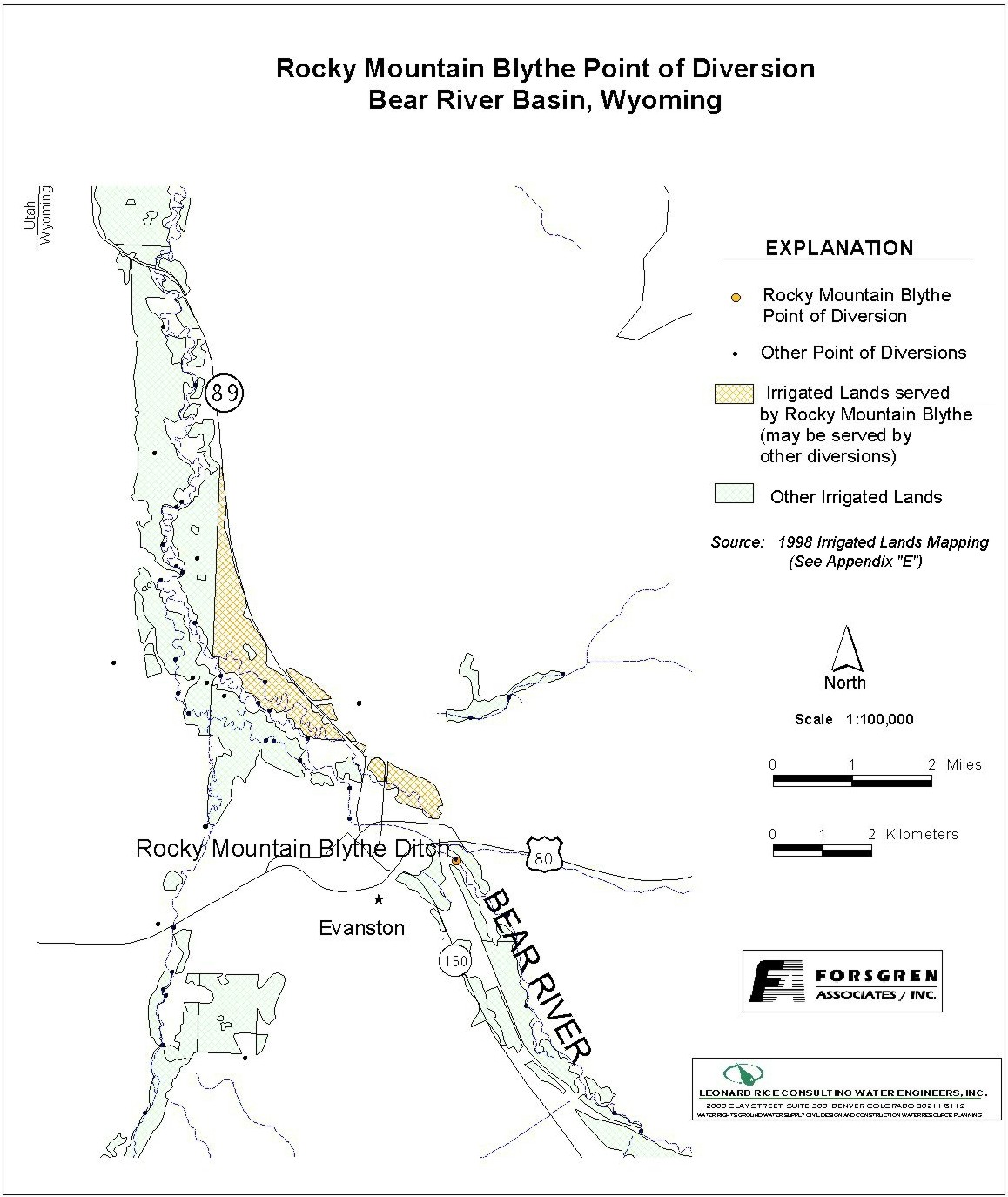
Appendix D Key Structures and Diversions ROCKY MOUNTAIN & BLYTHE DIVERSION |
| PREPARED BY: | Bear River Basin Planning Team |
| DATE: | February 25, 2002 |
| Diversion Description: The headgate structure consists of a broken concrete headwall constructed in 1918. There is a steel slide gate with a 30-inch culvert. There is a secondary downstream gate controlling flow across interstate-80 that is used. | 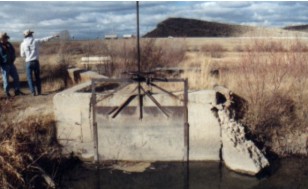 Rocky Mountain & Blythe |
|
Conveyance Description: Open channel canal, approximately 15,840 feet in length.1
Direct Flow Water Rights:2
| Priority Date | Permit Number |
Permitted Use | Permitted Acres |
Flow (CFS) |
Cumulative (CFS) |
Comments |
|---|---|---|---|---|---|---|
| -1875 | Terr | Irrigation | 20 | 0.28 | 0.28 | (John Felter) |
| -1875 | Terr | Irrigation | 129 | 1.84 | 2.12 | (John Felter) |
| -1875 | Terr | Irrigation | 11 | 0.15 | 2.27 | (John Felter) |
| -1878 | Terr | Irrigation, Storage | 18 | 0.25 | 2.52 | (Faulkner Terr) |
| 05-05-1882 | Terr | Irrigation | 30 | 0.42 | 2.94 | (John Fielding) |
| 05-05-1882 | Terr | Irrigation | 82.75 | 1.18 | 4.12 | (John Fielding) |
| 04-01-1889 | Terr | Irrigation | 64.80 | 0.92 | 5.04 | (Compton Irr) |
| 07-16-1891 | Terr | Irrigation | 6 | 0.08 | 5.12 | (Barnes) |
| 05-14-1896 | 1213 | Irrigation | 58.40 | 0.83 | 5.95 | (Dunford-Danks) |
| 05-14-1896 | 1213 | Mun | 25.60 | 0.37 | 6.32 | (Dunford-Danks) |
| 03-20-1897 | 1488 | Irrigation | 40 | 0.57 | 6.89 | (Longdon) |
| 05-24-1897 | 1607 | Irrigation, Domestic, Storage | 7.50 | 0.11 | 7.00 | (Lyndon) |
| 11-17-1897 | 1662 | Irrigation | 19 | 0.27 | 7.27 | (Danks) |
| 10-13-1898 | 378E | Irrigation | 63 | 0.90 | 8.17 | |
| 05-10-1902 | 831E | Irrigation | 70 | 1.00 | 9.17 | |
| 05-10-1902 | 831E | Irrigation | 35 | 0.50 | 9.67 | |
| 07-28-1908 | 1418E | Irrigation, Domestic | 6 | 0.08 | 9.75 | (Trouble Enl Felter) |
| 12-04-1914 | 3078E | Irrigation | 19 | 0.27 | 10.02 | ENL CROMPTON |
| 12-04-1914 | 3079E | Irrigation | 12 | 0.17 | 10.19 | |
| 12-04-1914 | 3079E | Supplemental Supply | 61 | Wardle No. 1 (Pleasant Valley or Sulphur Cr.) | ||
| 06-11-1920 | 4169E | Irrigation | 40 | 0.57 | 10.76 | |
| 11-13-1934 | 5019E | Reservoir Supply | 79.46 A/F | (1st Enl Crompton Res) |
Associated Storage Rights:
| Reservoir | Shareholder | Volume (Acre-ft) |
Est. % of Shares Used this Diversion3 | Comments |
|---|---|---|---|---|
| Sulphur Creek | Gary Ellingford | 25 | 100% | |
| Sulphur Creek | James Crompton | 58 | 100% | |
| Sulphur Creek | Ila Crompton | 58 | 100% | |
| Sulphur Creek | Lowham Ranches | 444 | 5% | |
| Sulphur Creek | Painter Co. | 274 | 100% | |
| Sulphur Creek | Ranold Phillips | 7 | 100% |
Irrigation Practices: Land is all flood irrigated.3
Estimated Diversion Efficiency: Most of the water is used in the top third of the canal. The largest losses tend to occur in the bottom two-thirds. The city of Evanston is planning on using this canal to irrigate their cemetery, and will likely clean and repair the canal in the near future.3
Calculated Diversion Efficiency = Conveyance Efficiency X Application Efficiency:
Conveyance Efficiency: 65% Application Efficiency: 55% Overall Diversion Efficiency: 36% Conveyance efficiency is estimated by total length of main canal. Application efficiency for flood irrigation and sprinkler irrigation is estimated at 55% and 85% respectively.
Crop Types / Consumptive Use: Water is used entirely to irrigate mixed meadow grasses, primarily Meadow Foxtail, Redtop, Orchard Grass, etc.3
Return Flows: Excess return flow is primarily split between the John Simms Canal (approx. 70%) and the SP Ramsey Canal (approx. 30%)
The following return flow pattern was adopted for modeling in this study are as follows:
		Month
      (after initial Diversion)	 Percent of Return
		0			70%
		1			20%
		2			10%
		3			 0%
                                       100%
Other Operational Information: The Rocky Mountain & Blythe also delivers water to the Crompton Reservoir.
References:
Monthly Diversion Records
Rocky Mountain & Blythe
| YEAR | MAY | JUNE | JULY | AUGUST | SEPTEMBER | ||||||||||
|---|---|---|---|---|---|---|---|---|---|---|---|---|---|---|---|
| Total of Daily Ave for Month | Average CFS |
Monthly Total Ac-Ft |
Total of Daily Ave for Month | Average CFS |
Monthly Total Ac-Ft |
Total of Daily Ave for Month | Average CFS |
Monthly Total Ac-Ft |
Total of Daily Ave for Month | Average CFS |
Monthly Total Ac-Ft |
Total of Daily Ave for Month | Average CFS |
Monthly Total Ac-Ft | |
| *1970 | |||||||||||||||
| 1971 | 267 | 8.6 | 529.6 | 494 | 16.5 | 979.8 | 224 | 7.2 | 444.3 | 258 | 8.3 | 511.7 | 99 | 3.3 | 196.4 |
| 1972 | 322 | 10.4 | 638.7 | 458 | 15.3 | 908.4 | 194 | 6.3 | 384.8 | 159 | 5.1 | 315.4 | 172 | 5.7 | 341.2 |
| 1973 | 169 | 5.5 | 335.2 | 509 | 17.0 | 1009.6 | 244 | 7.9 | 484.0 | 148 | 4.8 | 293.6 | 189 | 6.3 | 374.9 |
| 1974 | 256 | 8.3 | 507.8 | 339 | 11.3 | 672.4 | 203 | 6.5 | 402.6 | 104 | 3.4 | 206.3 | 161 | 5.4 | 319.3 |
| 1975 | 70 | 2.3 | 138.8 | 190 | 6.3 | 376.9 | 264 | 8.5 | 523.6 | 162 | 5.2 | 321.3 | 263 | 8.8 | 521.7 |
| 1976 | 102 | 3.3 | 202.3 | 321 | 10.7 | 636.7 | 222 | 7.2 | 440.3 | 119 | 3.8 | 236.0 | 117 | 3.9 | 232.1 |
| 1977 | 185 | 6.0 | 366.9 | 229 | 7.6 | 454.2 | 124 | 4.0 | 246.0 | 71 | 2.3 | 140.8 | 36 | 1.2 | 71.4 |
| 1978 | 396 | 12.8 | 785.5 | 463 | 15.4 | 918.3 | 342 | 11.0 | 678.3 | 180 | 5.8 | 357.0 | 144 | 4.8 | 285.6 |
| 1979 | 308 | 9.9 | 610.9 | 343 | 11.4 | 680.3 | 228 | 7.4 | 452.2 | 136 | 4.4 | 269.8 | 88 | 2.9 | 174.5 |
| 1980 | 31 | 1.0 | 61.5 | 349 | 11.6 | 692.2 | 276 | 8.9 | 547.4 | 193 | 6.2 | 382.8 | 37 | 1.2 | 73.4 |
| 1981 | 171 | 5.5 | 339.2 | 336 | 11.2 | 666.4 | 243 | 7.8 | 482.0 | 112 | 3.6 | 222.1 | 95 | 3.2 | 188.4 |
| 1982 | 264 | 8.5 | 523.6 | 491 | 16.4 | 973.9 | 343 | 11.1 | 680.3 | 189 | 6.1 | 374.9 | 284 | 9.5 | 563.3 |
| 1983 | 59 | 1.9 | 117.0 | 80 | 2.7 | 158.7 | 517 | 16.7 | 1025.5 | 549 | 17.7 | 1088.9 | 353 | 11.8 | 700.2 |
| 1984 | 13 | 0.4 | 25.8 | 317 | 10.6 | 628.8 | 667 | 21.5 | 1323.0 | 354 | 11.4 | 702.1 | 101 | 3.4 | 200.3 |
| 1985 | 283 | 9.1 | 561.3 | 603 | 20.1 | 1196.0 | 323 | 10.4 | 640.7 | 169 | 5.5 | 335.2 | 214 | 7.1 | 424.5 |
| 1986 | 82 | 2.6 | 162.6 | 335 | 11.2 | 664.5 | 156 | 5.0 | 309.4 | 249 | 8.0 | 493.9 | 300 | 10.0 | 595.0 |
| 1987 | 257 | 8.3 | 509.8 | 306 | 10.2 | 606.9 | 264 | 8.5 | 523.6 | 178 | 5.7 | 353.1 | 162 | 5.4 | 321.3 |
| 1988 | 280 | 9.0 | 555.4 | 286 | 9.5 | 567.3 | 138 | 4.5 | 273.7 | 185 | 6.0 | 366.9 | 124 | 4.1 | 246.0 |
| 1989 | 890 | 28.7 | 1765.3 | 885 | 29.5 | 1755.4 | 270 | 8.7 | 535.5 | 142 | 4.6 | 281.7 | 30 | 1.0 | 59.5 |
| 1990 | 160 | 5.2 | 317.4 | 394 | 13.1 | 781.5 | 251 | 8.1 | 497.9 | 90 | 2.9 | 178.5 | 76 | 2.5 | 150.7 |
| 1991 | 484 | 15.6 | 960.0 | 473 | 15.8 | 938.2 | 268 | 8.6 | 531.6 | 115 | 3.7 | 228.1 | 161 | 5.4 | 319.3 |
| 1992 | 283 | 9.1 | 561.3 | 300 | 10.0 | 595.0 | 165 | 5.3 | 327.3 | 80 | 2.6 | 158.7 | 68 | 2.3 | 134.9 |
| 1993 | 47 | 1.5 | 93.2 | 667 | 22.2 | 1323.0 | 389 | 12.5 | 771.6 | 69 | 2.2 | 136.9 | 88 | 2.9 | 174.5 |
| 1994 | 218 | 7.0 | 432.4 | 263 | 8.8 | 521.7 | 136 | 4.4 | 269.8 | 85 | 2.7 | 168.6 | 121 | 4.0 | 240.0 |
| 1995 | 29 | 0.9 | 57.5 | 205 | 6.8 | 406.6 | 325 | 10.5 | 644.6 | 165 | 5.3 | 327.3 | 289 | 9.6 | 573.2 |
| 1996 | 478 | 15.4 | 948.1 | 510 | 17.0 | 1011.6 | 294 | 9.5 | 583.1 | 144 | 4.6 | 285.6 | 131 | 4.4 | 259.8 |
| 1997 | 170.1 | 5.5 | 337.4 | 253.4 | 8.4 | 502.6 | 255.7 | 8.2 | 507.2 | 160.7 | 5.2 | 318.7 | 50.2 | 1.7 | 99.6 |
| 1998 | 149.1 | 4.8 | 295.7 | 153 | 5.1 | 303.5 | 363.6 | 11.7 | 721.2 | 69.4 | 2.2 | 137.7 | 73 | 2.4 | 144.8 |
| 1999 | 265 | 8.5 | 525.6 | 425 | 14.2 | 843.0 | 263 | 8.5 | 521.7 | 233 | 7.5 | 462.1 | 291 | 9.7 | 577.2 |
| AVERAGES | 7.4 | 457.4 | 12.6 | 750.8 | 8.8 | 543.9 | 5.4 | 333.0 | 5.0 | 295.3 | |||||