Wyoming State Water Plan
Wyoming State Water Plan
Wyoming Water Development Office
6920 Yellowtail Rd
Cheyenne, WY 82002
Phone: 307-777-7626

Wyoming Water Development Office
6920 Yellowtail Rd
Cheyenne, WY 82002
Phone: 307-777-7626


| SUBJECT: |
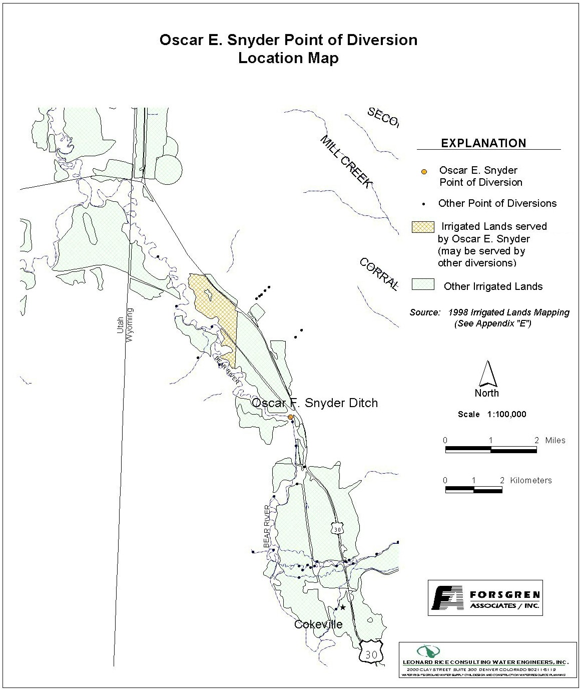
Appendix D Key Structures and Diversions OSCAR E. SNYDER CANAL DIVERSION |
| PREPARED BY: | Bear River Basin Planning Team |
| DATE: | August 7, 2000 |
| Diversion Description: The Oscar E. Snyder Canal diversion structure consists of a steel flume with a 7-foor rectangular slide gate. | 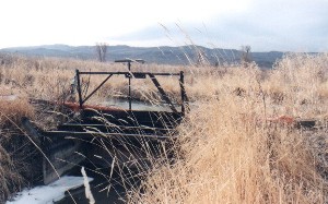 |
|
Conveyance Description: Open channel canal.1
Direct Flow Water Rights:2
| Priority Date | Permit Number |
Permitted Use | Permitted Acres |
Flow (CFS) |
Cumulative (CFS) |
Comments |
|---|---|---|---|---|---|---|
| 05-30-1881 | Terr | Irrigation, Domestic, Storage | 355 | 5.07 | 5.07 | |
| 05-04-1954 | 5849E | Irrigation | 441.87 | 6.31 | 11.38 |
Associated Storage Rights: None
Irrigation Practices: Land is flood irrigated.3
Estimated Diversion Efficiency:
Calculated Diversion Efficiency = Conveyance Efficiency X Application Efficiency:
Conveyance Efficiency: 65% Application Efficiency: 55% Overall Diversion Efficiency: 36% Conveyance efficiency is estimated by total length of main canal. Application efficiency for flood irrigation and sprinkler irrigation is estimated at 55% and 85% respectively.
Crop Types / Consumptive Use: Water is used entirely to irrigate meadow grasses (Timothy, Meadow Foxtail), etc.3
Return Flows: Return flow is captured by the Cook Brothers Ditch (approx. 50%) with the remainder returning directly to the Bear River.
The following return flow pattern was adopted for modeling in this study are as follows:
The following return flow pattern was adopted for modeling in this study are as follows:
		Month
      (after initial Diversion)	 Percent of Return
		0			70%
		1			20%
		2			10%
                3                        0%
                                       100%
References:
Monthly Diversion Records
Oscar E. Snyder
| YEAR | MAY | JUNE | JULY | AUGUST | SEPTEMBER | ||||||||||
|---|---|---|---|---|---|---|---|---|---|---|---|---|---|---|---|
| Total of Daily Ave for Month | Average CFS |
Monthly Total Ac-Ft |
Total of Daily Ave for Month | Average CFS |
Monthly Total Ac-Ft |
Total of Daily Ave for Month | Average CFS |
Monthly Total Ac-Ft |
Total of Daily Ave for Month | Average CFS |
Monthly Total Ac-Ft |
Total of Daily Ave for Month | Average CFS |
Monthly Total Ac-Ft | |
| 1970 | 283 | 9.1 | 561.3 | 1327 | 44.2 | 2632.1 | 896 | 28.9 | 1777.2 | 31 | 1.0 | 61.5 | 0 | 0.0 | 0.0 |
| 1971 | 231 | 7.5 | 458.2 | 619 | 20.6 | 1227.8 | 653 | 21.1 | 1295.2 | 172 | 5.5 | 341.2 | 70 | 2.3 | 138.8 |
| 1972 | 124 | 4.0 | 246.0 | 1509 | 50.3 | 2993.1 | 861 | 27.8 | 1707.8 | 37 | 1.2 | 73.4 | 0 | 0.0 | 0.0 |
| 1973 | 0 | 0.0 | 0.0 | 610 | 20.3 | 1209.9 | 741 | 23.9 | 1469.8 | 133 | 4.3 | 263.8 | 436 | 14.5 | 864.8 |
| 1974 | 1095 | 35.3 | 2171.9 | 875 | 29.2 | 1735.5 | 550 | 17.7 | 1090.9 | 85 | 2.7 | 168.6 | 0 | 0.0 | 0.0 |
| 1975 | 304 | 9.8 | 603.0 | 664 | 22.1 | 1317.0 | 995 | 32.1 | 1973.6 | 175 | 5.6 | 347.1 | 16 | 0.5 | 31.7 |
| 1976 | 140 | 4.5 | 277.7 | 539 | 18.0 | 1069.1 | 402 | 13.0 | 797.4 | 114 | 3.7 | 226.1 | 1 | 0.0 | 2.0 |
| 1977 | 183 | 5.9 | 363.0 | 135 | 4.5 | 267.8 | 111 | 3.6 | 220.2 | 178 | 5.7 | 353.1 | 30 | 1.0 | 59.5 |
| 1978 | 0 | 0.0 | 0.0 | 676 | 22.5 | 1340.8 | 367 | 11.8 | 727.9 | 0 | 0.0 | 0.0 | 181 | 6.0 | 359.0 |
| 1979 | 31 | 1.0 | 61.5 | 1050 | 35.0 | 2082.6 | 459 | 14.8 | 910.4 | 394 | 12.7 | 781.5 | 472 | 15.7 | 936.2 |
| 1980 | 130 | 4.2 | 257.9 | 968 | 32.3 | 1920.0 | 522 | 16.8 | 1035.4 | 756 | 24.4 | 1499.5 | 602 | 20.1 | 1194.0 |
| 1981 | 508 | 16.4 | 1007.6 | 964 | 32.1 | 1912.1 | 508 | 16.4 | 1007.6 | 326 | 10.5 | 646.6 | 83 | 2.8 | 164.6 |
| 1982 | 69 | 2.2 | 136.9 | 877 | 29.2 | 1739.5 | 1118 | 36.1 | 2217.5 | 378 | 12.2 | 749.8 | 341 | 11.4 | 676.4 |
| 1983 | 393 | 12.7 | 779.5 | 1800 | 60.0 | 3570.2 | 453 | 14.6 | 898.5 | 374 | 12.1 | 741.8 | 84 | 2.8 | 166.6 |
| 1984 | 1033 | 33.3 | 2048.9 | 1354 | 45.1 | 2685.6 | 688 | 22.2 | 1364.6 | 0 | 0.0 | 0.0 | 0 | 0.0 | 0.0 |
| 1985 | 566 | 18.3 | 1122.6 | 1381 | 46.0 | 2739.2 | 799 | 25.8 | 1584.8 | 114 | 3.7 | 226.1 | 348 | 11.6 | 690.2 |
| 1986 | 168 | 5.4 | 333.2 | 1800 | 60.0 | 3570.2 | 695 | 22.4 | 1378.5 | 165 | 5.3 | 327.3 | 349 | 11.6 | 692.2 |
| 1987 | 249 | 8.0 | 493.9 | 924 | 30.8 | 1832.7 | 571 | 18.4 | 1132.6 | 204 | 6.6 | 404.6 | 317 | 10.6 | 628.8 |
| 1988 | 438 | 14.1 | 868.8 | 737 | 24.6 | 1461.8 | 376 | 12.1 | 745.8 | 124 | 4.0 | 246.0 | 102 | 3.4 | 202.3 |
| 1989 | 565 | 18.2 | 1120.7 | 734 | 24.5 | 1455.9 | 506 | 16.3 | 1003.6 | 127 | 4.1 | 251.9 | 30 | 1.0 | 59.5 |
| 1990 | 100 | 3.2 | 198.3 | 432 | 14.4 | 856.9 | 470 | 15.2 | 932.2 | 141 | 4.5 | 279.7 | 19 | 0.6 | 37.7 |
| 1991 | 209 | 6.7 | 414.5 | 409 | 13.6 | 811.2 | 422 | 13.6 | 837.0 | 179 | 5.8 | 355.0 | 111 | 3.7 | 220.2 |
| 1992 | 155 | 5.0 | 307.4 | 150 | 5.0 | 297.5 | 155 | 5.0 | 307.4 | 155 | 5.0 | 307.4 | 105 | 3.5 | 208.3 |
| 1993 | 487 | 15.7 | 966.0 | 760 | 25.3 | 1507.4 | 470 | 15.2 | 932.2 | 179 | 5.8 | 355.0 | 93 | 3.1 | 184.5 |
| 1994 | 487 | 15.7 | 966.0 | 346 | 11.5 | 686.3 | 207 | 6.7 | 410.6 | 161 | 5.2 | 319.3 | 57 | 1.9 | 113.1 |
| 1995 | 427 | 13.8 | 846.9 | 773 | 25.8 | 1533.2 | 678 | 21.9 | 1344.8 | 167 | 5.4 | 331.2 | 180 | 6.0 | 357.0 |
| 1996 | 871 | 28.1 | 1727.6 | 771 | 25.7 | 1529.3 | 321 | 10.4 | 636.7 | 53 | 1.7 | 105.1 | 7 | 0.2 | 13.9 |
| 1997 | 287.5 | 9.3 | 570.2 | 490.4 | 16.3 | 927.7 | 548.9 | 17.7 | 1088.7 | 65.9 | 2.1 | 130.7 | 98.5 | 3.3 | 195.4 |
| 1998 | 0 | 0.0 | 0.0 | 712.4 | 23.7 | 1413.0 | 423.6 | 13.7 | 840.2 | 61.5 | 2.0 | 122.0 | 123 | 4.1 | 244.0 |
| AVERAGES | 10.6 | 652.0 | 28.0 | 1667.9 | 17.8 | 1092.0 | 5.6 | 345.4 | 4.7 | 278.7 | |||||