Wyoming State Water Plan
Wyoming State Water Plan
Wyoming Water Development Office
6920 Yellowtail Rd
Cheyenne, WY 82002
Phone: 307-777-7626

Wyoming Water Development Office
6920 Yellowtail Rd
Cheyenne, WY 82002
Phone: 307-777-7626


| SUBJECT: |
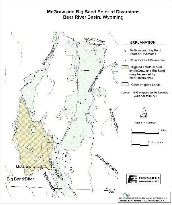
Appendix D Key Structures and Diversions McGRAW (and BIG BEND) DIVERSION |
| PREPARED BY: | Bear River Basin Planning Team |
| DATE: | August 7, 2000 |
| Diversion Description: The diversion structure consists of a single 48-inch cmp culvert, concrete headwall, and slide gate. The river is diverted using piled rocks and logs cabled into the bank. | 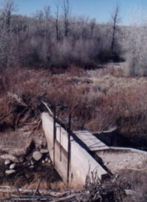 McGraw diversion structure |
|
Conveyance Description: Open channel canal, approximately 5,280 feet in length.1 Conveyance Description: Open Channel Canal, approximately 31,680 feet in length.1
Direct Flow Water Rights:2
| Priority Date | Permit Number |
Permitted Use | Permitted Acres |
Flow (CFS) |
Cumulative (CFS) |
Comments |
|---|---|---|---|---|---|---|
| 09-30-1883 | Terr | Irrigation | 260 | 3.71 | 3.71 | |
| 07-12-1897 | 1545 | Irrigation | 315 | 4.50 | 8.21 | |
| 09-07-1910 | 10186 | Irrigation | 468 | 6.68 | 14.89 | Big Bend |
Associated Storage Rights:
| Reservoir | Shareholder | Volume (Acre-ft) |
Est. % of Shares Used this Diversion3 | Comments |
|---|---|---|---|---|
| Whitney | Joe Cowan | 220 | 100% |
Irrigation Practices: Land is all flood irrigated.3
Estimated Diversion Efficiency: Canal losses are relatively high due to porous nature of soils in the higher reaches of the Upper Bear.
Calculated Diversion Efficiency = Conveyance Efficiency X Application Efficiency:
Conveyance Efficiency: 55% Application Efficiency: 55% Overall Diversion Efficiency: 30%
Conveyance efficiency is estimated by total length of main canal. Application efficiency for flood irrigation and sprinkler irrigation is estimated at 55% and 85% respectively.
Crop Types / Consumptive Use: Water is used entirely to irrigate meadow grasses, primarily Timothy, Meadow Foxtail, etc.3
Return Flows: Return flow primarily flows into the Lewis Ditch
The following return flow pattern was adopted for modeling in this study are as follows:
		Month
      (after initial Diversion)	 Percent of Return
		0			70%
		1			20%
		2			10%
		3			0%
Other Operational Information: Irrigation from this canal typically commences by May 1st each year. They typically shut off on October 1st.3
References:
Monthly Diversion Records
McGraw (and Big Bend)
| YEAR | MAY | JUNE | JULY | AUGUST | SEPTEMBER | ||||||||||
|---|---|---|---|---|---|---|---|---|---|---|---|---|---|---|---|
| Total of Daily Ave for Month | Average CFS |
Monthly Total Ac-Ft |
Total of Daily Ave for Month | Average CFS |
Monthly Total Ac-Ft |
Total of Daily Ave for Month | Average CFS |
Monthly Total Ac-Ft |
Total of Daily Ave for Month | Average CFS |
Monthly Total Ac-Ft |
Total of Daily Ave for Month | Average CFS |
Monthly Total Ac-Ft | |
| *1970 | |||||||||||||||
| 1971 | 57 | 1.8 | 113.1 | 740 | 24.7 | 1467.8 | 666 | 21.5 | 1321.0 | 304 | 9.8 | 603.0 | 231 | 7.7 | 458.2 |
| 1972 | 179 | 5.8 | 355.0 | 945 | 31.5 | 1874.4 | 471 | 15.2 | 934.2 | 223 | 7.2 | 442.3 | 43 | 1.4 | 85.3 |
| 1973 | 132 | 4.3 | 261.8 | 1159 | 38.6 | 2298.8 | 430 | 13.9 | 852.9 | 232 | 7.5 | 460.2 | 225 | 7.5 | 446.3 |
| 1974 | 215 | 6.9 | 426.4 | 1309 | 43.6 | 2596.4 | 338 | 10.9 | 670.4 | 188 | 6.1 | 372.9 | 146 | 4.9 | 289.6 |
| 1975 | 281 | 9.1 | 557.4 | 618 | 20.6 | 1225.8 | 563 | 18.2 | 1116.7 | 404 | 13.0 | 801.3 | 208 | 6.9 | 412.6 |
| 1976 | 361 | 11.6 | 716.0 | 680 | 22.7 | 1348.8 | 283 | 9.1 | 561.3 | 137 | 4.4 | 271.7 | 80 | 2.7 | 158.7 |
| 1977 | 153 | 4.9 | 303.5 | 253 | 8.4 | 501.8 | 111 | 3.6 | 220.2 | 45 | 1.5 | 89.3 | 41 | 1.4 | 81.3 |
| 1978 | 338 | 10.9 | 670.4 | 1037 | 34.6 | 2056.9 | 431 | 13.9 | 854.9 | 202 | 6.5 | 400.7 | 204 | 6.8 | 404.6 |
| 1979 | 295 | 9.5 | 585.1 | 681 | 22.7 | 1350.7 | 214 | 6.9 | 424.5 | 178 | 5.7 | 353.1 | 64 | 2.1 | 126.9 |
| 1980 | 114 | 3.7 | 226.1 | 860 | 28.7 | 1705.8 | 412 | 13.3 | 817.2 | 242 | 7.8 | 480.0 | 123 | 4.1 | 244.0 |
| 1981 | 599 | 19.3 | 1188.1 | 751 | 25.0 | 1489.6 | 340 | 11.0 | 674.4 | 167 | 5.4 | 331.2 | 103 | 3.4 | 204.3 |
| 1982 | 344 | 11.1 | 682.3 | 900 | 30.0 | 1785.1 | 612 | 19.7 | 1213.9 | 346 | 11.2 | 686.3 | 231 | 7.7 | 458.2 |
| 1983 | 0 | 0.0 | 0.0 | 433 | 14.4 | 858.8 | 685 | 22.1 | 1358.7 | 493 | 15.9 | 977.9 | 441 | 14.7 | 874.7 |
| 1984 | 220 | 7.1 | 436.4 | 860 | 28.7 | 1705.8 | 720 | 23.2 | 1428.1 | 340 | 11.0 | 674.4 | 422 | 14.1 | 837.0 |
| 1985 | 785 | 25.3 | 1557.0 | 838 | 27.9 | 1662.1 | 402 | 13.0 | 797.4 | 270 | 8.7 | 535.5 | 410 | 13.7 | 813.2 |
| 1986 | 241 | 7.8 | 478.0 | 1379 | 46.0 | 2735.2 | 677 | 21.8 | 1342.8 | 393 | 12.7 | 779.5 | 280 | 9.3 | 555.4 |
| 1987 | 589 | 19.0 | 1168.3 | 718 | 23.9 | 1424.1 | 285 | 9.2 | 565.3 | 228 | 7.4 | 452.2 | 130 | 4.3 | 257.9 |
| 1988 | 824 | 26.6 | 1634.4 | 599 | 20.0 | 1188.1 | 131 | 4.2 | 259.8 | 0 | 0.0 | 0.0 | 0 | 0.0 | 0.0 |
| 1989 | 964 | 31.1 | 1912.1 | 628 | 20.9 | 1245.6 | 206 | 6.6 | 408.6 | 113 | 3.6 | 224.1 | 23 | 0.8 | 45.6 |
| 1990 | 376 | 12.1 | 745.8 | 806 | 26.9 | 1598.7 | 389 | 12.5 | 771.6 | 170 | 5.5 | 337.2 | 84 | 2.8 | 166.6 |
| 1991 | 438 | 14.1 | 868.8 | 890 | 29.7 | 1765.3 | 307 | 9.9 | 608.9 | 944 | 30.5 | 1872.4 | 123 | 4.1 | 244.0 |
| 1992 | 575 | 18.5 | 1140.5 | 411 | 13.7 | 815.2 | 227 | 7.3 | 450.2 | 80 | 2.6 | 158.7 | 63 | 2.1 | 125.0 |
| 1993 | 553 | 17.8 | 1096.9 | 937 | 31.2 | 1858.5 | 649 | 20.9 | 1287.3 | 505 | 16.3 | 1001.7 | 261 | 8.7 | 517.7 |
| 1994 | 936 | 30.2 | 1856.5 | 594 | 19.8 | 1178.2 | 204 | 6.6 | 404.6 | 132 | 4.3 | 261.8 | 72 | 2.4 | 142.8 |
| 1995 | 511 | 16.5 | 1013.6 | 791 | 26.4 | 1568.9 | 837 | 27.0 | 1660.2 | 500 | 16.1 | 991.7 | 293 | 9.8 | 581.2 |
| 1996 | 855 | 27.6 | 1695.9 | 1027 | 34.2 | 2037.0 | 336 | 10.8 | 666.4 | 233 | 7.5 | 462.1 | 154 | 5.1 | 305.5 |
| 1997 | 1410.9 | 45.5 | 2798.5 | 1353 | 45.1 | 2683.6 | 393.5 | 12.7 | 780.5 | 151.3 | 4.9 | 300.1 | 333.8 | 11.1 | 662.1 |
| 1998 | 847 | 27.3 | 1680.0 | 821.6 | 27.4 | 1629.6 | 960 | 31.0 | 1904.1 | 816 | 26.3 | 1618.5 | 480.5 | 16.0 | 953.1 |
| 1999 | 718 | 23.2 | 1424.1 | 858 | 28.6 | 1701.8 | 527 | 17.0 | 1045.3 | 606 | 19.5 | 1202.0 | 372 | 12.4 | 737.9 |
| AVERAGES | 15.5 | 951.4 | 27.4 | 1633.1 | 14.2 | 875.9 | 9.6 | 591.1 | 6.5 | 385.8 | |||||