Wyoming State Water Plan
Wyoming State Water Plan
Wyoming Water Development Office
6920 Yellowtail Rd
Cheyenne, WY 82002
Phone: 307-777-7626

Wyoming Water Development Office
6920 Yellowtail Rd
Cheyenne, WY 82002
Phone: 307-777-7626


| SUBJECT: |
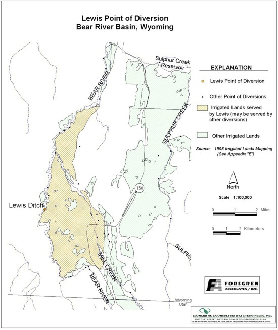
Appendix D Key Structures and Diversions LEWIS DIVERSION |
| PREPARED BY: | Bear River Basin Planning Team |
| DATE: | August 7, 2000 |
| Diversion Description:The diversion structure consists of a single 60-inch CMP culvert, concrete headwall with wings, and a steel slide gate. | 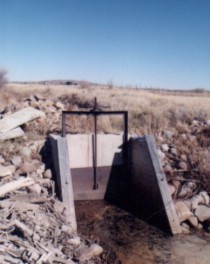 Lewis Headgate |
|
Conveyance Description: Open channel canal, approximately 15,840 feet in length.1
Direct Flow Water Rights:2
| Priority Date | Permit Number |
Permitted Use | Permitted Acres |
Flow (CFS) |
Cumulative (CFS) |
Comments |
|---|---|---|---|---|---|---|
| 09-23-1888 | Terr | Irrigation | 20 | 0.29 | 0.29 | Morse & Coffman |
| 10-04-1888 | Terr | Irrigation | 360 | 5.14 | 5.43 | |
| 04-20-1900 | 523E | Irrigation | 460 | 6.57 | 12.00 |
Associated Storage Rights:
| Reservoir | Shareholder | Volume (Acre-ft) |
Est. % of Shares Used this Diversion3 | Comments |
|---|---|---|---|---|
| Whitney | Moe Jackson | 123.75 | 25% | |
| Whitney | Darrell Goodfellow | 168.75 | 50% |
Irrigation Practices: Land is all flood irrigated.3
Estimated Diversion Efficiency: Canal losses are relatively high due to porous nature of soils in the higher reaches of the Upper Bear.
Calculated Diversion Efficiency = Conveyance Efficiency X Application Efficiency:
Conveyance Efficiency: 55% Application Efficiency: 55% Overall Diversion Efficiency: 30%
Conveyance efficiency is estimated by total length of main canal. Application efficiency for flood irrigation and sprinkler irrigation is estimated at 55% and 85% respectively.
Crop Types / Consumptive Use: Water is used entirely to irrigate meadow grasses, primarily Timothy, Meadow Foxtail, etc.3
Return Flows: Return flow is intercepted by Myers No. 1 Ditch.
The following return flow pattern was adopted for modeling in this study are as follows:
		Month
      (after initial Diversion)	 Percent of Return
		0			70%
		1			20%
		2			10%
		3			 0%
                                       100%
Other Operational Information: The Lewis Canal intercepts virtually all of the return flow and runoff from the Crown & Pine Grove Canals. During low flow periods, observed runoff has contributed as much as 3 CFS. The Lewis ditch converges with Mill Creek. Irrigation water diverted back out of Mill Creek approximately 1/4 mile downstream.3
References:
Monthly Diversion Records
Lewis
| YEAR | MAY | JUNE | JULY | AUGUST | SEPTEMBER | ||||||||||
|---|---|---|---|---|---|---|---|---|---|---|---|---|---|---|---|
| Total of Daily Ave for Month | Average CFS |
Monthly Total Ac-Ft |
Total of Daily Ave for Month | Average CFS |
Monthly Total Ac-Ft |
Total of Daily Ave for Month | Average CFS |
Monthly Total Ac-Ft |
Total of Daily Ave for Month | Average CFS |
Monthly Total Ac-Ft |
Total of Daily Ave for Month | Average CFS |
Monthly Total Ac-Ft | |
| *1970 | |||||||||||||||
| 1971 | 0 | 0.0 | 0.0 | 0 | 0.0 | 0.0 | 330 | 10.6 | 654.5 | 219 | 7.1 | 434.4 | 100 | 3.3 | 198.3 |
| 1972 | 0 | 0.0 | 0.0 | 78 | 2.6 | 154.7 | 310 | 10.0 | 614.9 | 186 | 6.0 | 368.9 | 0 | 0.0 | 0.0 |
| 1973 | 140 | 4.5 | 277.7 | 393 | 13.1 | 779.5 | 280 | 9.0 | 555.4 | 142 | 4.6 | 281.7 | 78 | 2.6 | 154.7 |
| 1974 | 196 | 6.3 | 388.8 | 374 | 12.5 | 741.8 | 190 | 6.1 | 376.9 | 96 | 3.1 | 190.4 | 73 | 2.4 | 144.8 |
| 1975 | 0 | 0.0 | 0.0 | 242 | 8.1 | 480.0 | 228 | 7.4 | 452.2 | 297 | 9.6 | 589.1 | 257 | 8.6 | 509.8 |
| 1976 | 0 | 0.0 | 0.0 | 190 | 6.3 | 376.9 | 349 | 11.3 | 692.2 | 139 | 4.5 | 275.7 | 78 | 2.6 | 154.7 |
| 1977 | 128 | 4.1 | 253.9 | 208 | 6.9 | 412.6 | 144 | 4.6 | 285.6 | 0 | 0.0 | 0.0 | 3 | 0.1 | 6.0 |
| 1978 | 22 | 0.7 | 43.6 | 252 | 8.4 | 499.8 | 216 | 7.0 | 428.4 | 171 | 5.5 | 339.2 | 48 | 1.6 | 95.2 |
| 1979 | 36 | 1.2 | 71.4 | 284 | 9.5 | 563.3 | 239 | 7.7 | 474.0 | 180 | 5.8 | 357.0 | 59 | 2.0 | 117.0 |
| 1980 | 19 | 0.6 | 37.7 | 129 | 4.3 | 255.9 | 211 | 6.8 | 418.5 | 161 | 5.2 | 319.3 | 35 | 1.2 | 69.4 |
| 1981 | 0 | 0.0 | 0.0 | 245 | 8.2 | 486.0 | 168 | 5.4 | 333.2 | 48 | 1.5 | 95.2 | 0 | 0.0 | 0.0 |
| 1982 | 1 | 0.0 | 2.0 | 344 | 11.5 | 682.3 | 336 | 10.8 | 666.4 | 114 | 3.7 | 226.1 | 140 | 4.7 | 277.7 |
| 1983 | 39 | 1.3 | 77.4 | 41 | 1.4 | 81.3 | 115 | 3.7 | 228.1 | 199 | 6.4 | 394.7 | 144 | 4.8 | 285.6 |
| 1984 | 0 | 0.0 | 0.0 | 88 | 2.9 | 174.5 | 232 | 7.5 | 460.2 | 94 | 3.0 | 186.4 | 53 | 1.8 | 105.1 |
| 1985 | 80 | 2.6 | 158.7 | 148 | 4.9 | 293.6 | 305 | 9.8 | 605.0 | 282 | 9.1 | 559.3 | 70 | 2.3 | 138.8 |
| 1986 | 205 | 6.6 | 406.6 | 405 | 13.5 | 803.3 | 279 | 9.0 | 553.4 | 244 | 7.9 | 484.0 | 78 | 2.6 | 154.7 |
| 1987 | 225 | 7.3 | 446.3 | 66 | 2.2 | 130.9 | 282 | 9.1 | 559.3 | 178 | 5.7 | 353.1 | 45 | 1.5 | 89.3 |
| 1988 | 45 | 1.5 | 89.3 | 131 | 4.4 | 259.8 | 205 | 6.6 | 406.6 | 22 | 0.7 | 43.6 | 13 | 0.4 | 25.8 |
| 1989 | 36 | 1.2 | 71.4 | 186 | 6.2 | 368.9 | 209 | 6.7 | 414.5 | 91 | 2.9 | 180.5 | 16 | 0.5 | 31.7 |
| 1990 | 33 | 1.1 | 65.5 | 61 | 2.0 | 121.0 | 234 | 7.5 | 464.1 | 106 | 3.4 | 210.2 | 22 | 0.7 | 43.6 |
| 1991 | 0 | 0.0 | 0.0 | 0 | 0.0 | 0.0 | 0 | 0.0 | 0.0 | 0 | 0.0 | 0.0 | 0 | 0.0 | 0.0 |
| 1992 | 131 | 4.2 | 259.8 | 178 | 5.9 | 353.1 | 96 | 3.1 | 190.4 | 11 | 0.4 | 21.8 | 12 | 0.4 | 23.8 |
| 1993 | 2 | 0.1 | 4.0 | 101 | 3.4 | 200.3 | 210 | 6.8 | 416.5 | 146 | 4.7 | 289.6 | 83 | 2.8 | 164.6 |
| 1994 | 88 | 2.8 | 174.5 | 146 | 4.9 | 289.6 | 201 | 6.5 | 398.7 | 31 | 1.0 | 61.5 | 3 | 0.1 | 6.0 |
| 1995 | 0 | 0.0 | 0.0 | 131 | 4.4 | 259.8 | 179 | 5.8 | 355.0 | 104 | 3.4 | 206.3 | 65 | 2.2 | 128.9 |
| 1996 | 100 | 3.2 | 198.3 | 189 | 6.3 | 374.9 | 89 | 2.9 | 176.5 | 130 | 4.2 | 257.9 | 59 | 2.0 | 117.0 |
| 1997 | 19.8 | 0.6 | 39.3 | 137.2 | 4.6 | 272.1 | 96.4 | 3.1 | 191.2 | 117.4 | 3.8 | 232.9 | 155.9 | 5.2 | 309.2 |
| 1998 | 40.7 | 1.3 | 80.7 | 188.4 | 6.3 | 373.7 | 274.1 | 8.0 | 490.1 | 126.3 | 4.1 | 250.5 | 32.6 | 1.1 | 64.7 |
| 1999 | 7 | 0.2 | 13.9 | 235 | 7.8 | 466.1 | 114 | 3.7 | 226.1 | 70 | 2.3 | 138.8 | 21 | 0.7 | 41.7 |
| AVERAGES | 1.8 | 109.0 | 5.9 | 353.6 | 6.8 | 416.8 | 4.1 | 253.4 | 2.0 | 119.2 | |||||