Wyoming State Water Plan
Wyoming State Water Plan
Wyoming Water Development Office
6920 Yellowtail Rd
Cheyenne, WY 82002
Phone: 307-777-7626

Wyoming Water Development Office
6920 Yellowtail Rd
Cheyenne, WY 82002
Phone: 307-777-7626


| SUBJECT: |
Appendix D Key Structures and Diversions Crown & Pine Grove Diversions |
| PREPARED BY: | Bear River Basin Planning Team |
| DATE: | August 7, 2000 |
|
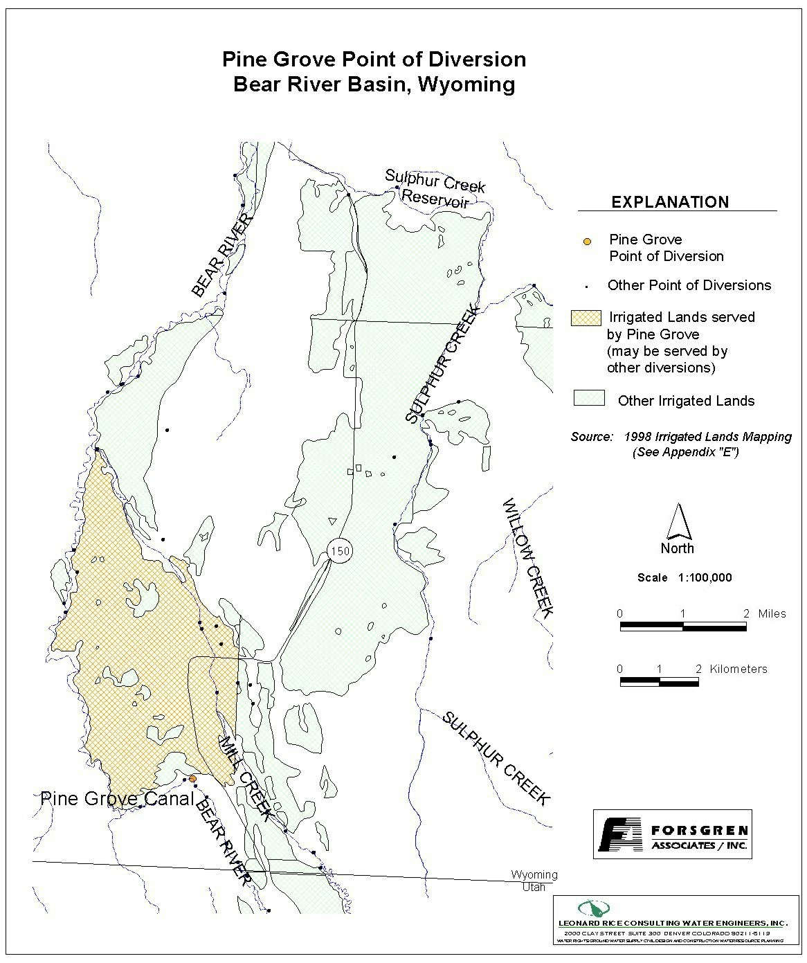
Diversion Description: The "Crown Ditch" and "Pine Grove Canal" are separate conveyances
with separate headgates. The two canals merge approximately 50 yards downstream of
the Crown diversion. There is a divider box located approximately 1/2 mile further
downstream. As a matter of practicality, these two diversions are typically regulated
together.
The Crown gate structure consists of a 60-inch diameter squash pipe with a slide gate. The Pine Grove gate structure is virtually identical to the Crown. |
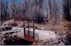 Crown Headgate |
|
Conveyance Description: Both the Crown and the Pine Grove are open channel canals.
Direct Flow Water Rights:2
| Priority Date | Permit Number |
Permitted Use | Permitted Acres |
Flow (CFS) |
Cumulative (CFS) |
Comments |
|---|---|---|---|---|---|---|
| 10-05-1890 | Terr | Irrigation | 20 | 0.28 | 0.28 | |
| 10-05-1890 | Terr | Irrigation | 160 | 2.28 | 2.56 | |
| 10-05-1890 | Terr | Irrigation | 135 | 1.92 | 4.48 | |
| 10-05-1890 | Terr | Irrigation | 365 | 5.21 | 9.69 | |
| 10-13-1890 | Terr | Irrigation | 140 | 2.00 | 11.69 | Pine Grove (lateral) |
| 10-13-1890 | Terr | Irrigation | 110 | 1.57 | 13.26 | Pine Grove (lateral) |
| 10-13-1890 | Terr | Irrigation | 773 | 11.04 | 24.30 | Pine Grove (lateral) |
| 06-30-1892 | 25E | Irrigation | 15 | 0.21 | 24.51 | Enl Pine Grove (lateral) |
| 04-13-1903 | 1021E | Irrigation | 155 | 2.21 | 26.72 | Enl Pine Grove (lateral) |
| 01-06-1908 | 1864E | Irrigation, Storage | 401 | 5.73 | 32.45 |
Associated Storage Rights:
| Reservoir | Shareholder | Volume (Acre-ft) |
Est. % of Shares Used this Diversion3 |
Comments |
|---|---|---|---|---|
| Whitney | Ted James | 64 | 100% | |
| Whitney | Moe Jackson | 123.75 | 25% | |
| Whitney | Darrell Goodfellow | 168.75 | 50% | |
| Whitney | Milton Johnson | 223.88 | 100% | |
| Whitney | J.C. Stauffer | 135 | 100% | |
| Whitney | Robert Reese | 61.75 | 100% |
Irrigation Practices: Land is all flood irrigated.3
Estimated Diversion Efficiency: Canal losses are relatively high due to porous nature of soils in the higher reaches of the Upper Bear.
Calculated Diversion Efficiency = Conveyance Efficiency X Application Efficiency:
Conveyance Efficiency: 50% Application Efficiency: 55% Overall Diversion Efficiency: 27% Conveyance efficiency is estimated by total length of main canal. Application efficiency for flood irrigation and sprinkler irrigation is estimated at 55% and 85% respectively.
Crop Types / Consumptive Use: Water is used entirely to irrigate meadow grasses, primarily Timothy, Meadow Foxtail, etc.3
Return Flows: Return flow is split between the Lewis Ditch (approx. 25%), Mill Creek (approx. 25%), and the Meyers No. 2 Ditch (approx. 50%).
The following return flow pattern was adopted for modeling in this study are as follows:
              Month
      (after initial Diversion)	 Percent of Return
		0			70%
		1			20%
		2			10%
		3			 0%
				       100%
References:
Monthly Diversion Records
Crown and Pine Grove
| YEAR | MAY | JUNE | JULY | AUGUST | SEPTEMBER | ||||||||||
|---|---|---|---|---|---|---|---|---|---|---|---|---|---|---|---|
| Total of Daily Ave for Month | Average CFS |
Monthly Total Ac-Ft |
Total of Daily Ave for Month | Average CFS |
Monthly Total Ac-Ft |
Total of Daily Ave for Month | Average CFS |
Monthly Total Ac-Ft |
Total of Daily Ave for Month | Average CFS |
Monthly Total Ac-Ft |
Total of Daily Ave for Month | Average CFS |
Monthly Total Ac-Ft | |
| *1970 | |||||||||||||||
| 1971 | 142 | 4.6 | 281.7 | 1212 | 40.4 | 2404.0 | 951 | 30.7 | 1886.3 | 361 | 11.6 | 716.0 | 285 | 9.5 | 565.3 |
| 1972 | 318 | 10.3 | 630.7 | 1384 | 46.1 | 2745.1 | 732 | 23.6 | 1451.9 | 311 | 10.0 | 616.9 | 343 | 11.4 | 680.3 |
| 1973 | 13 | 0.4 | 25.8 | 869 | 29.0 | 1723.6 | 892 | 28.8 | 1769.3 | 437 | 14.1 | 866.8 | 216 | 7.2 | 428.4 |
| 1974 | 147 | 4.7 | 291.6 | 1004 | 33.5 | 1991.4 | 695 | 22.4 | 1378.5 | 504 | 16.3 | 999.7 | 218 | 7.3 | 432.4 |
| 1975 | 61 | 2.0 | 121.0 | 942 | 31.4 | 1868.4 | 1048 | 33.8 | 2078.7 | 333 | 10.7 | 660.5 | 275 | 9.2 | 545.5 |
| 1976 | 252 | 8.1 | 499.8 | 948 | 31.6 | 1880.3 | 782 | 25.2 | 1551.1 | 385 | 12.4 | 763.6 | 347 | 11.6 | 688.3 |
| 1977 | 348 | 11.2 | 690.2 | 584 | 19.5 | 1158.3 | 112 | 3.6 | 222.1 | 60 | 1.9 | 119.0 | 81 | 2.7 | 160.7 |
| 1978 | 61 | 2.0 | 121.0 | 886 | 29.5 | 1757.4 | 153 | 4.9 | 303.5 | 383 | 12.4 | 759.7 | 95 | 3.2 | 188.4 |
| 1979 | 365 | 11.8 | 724.0 | 921 | 30.7 | 1826.8 | 704 | 22.7 | 1396.4 | 192 | 6.2 | 380.8 | 112 | 3.7 | 222.1 |
| 1980 | 0 | 0.0 | 0.0 | 1068 | 35.6 | 2118.3 | 928 | 29.9 | 1840.7 | 414 | 13.4 | 821.2 | 386 | 12.9 | 765.6 |
| 1981 | 29 | 0.9 | 57.5 | 989 | 33.0 | 1961.7 | 483 | 15.6 | 958.0 | 264 | 8.5 | 523.6 | 191 | 6.4 | 378.8 |
| 1982 | 33 | 1.1 | 65.5 | 1158 | 38.6 | 2296.9 | 917 | 29.6 | 1818.8 | 337 | 10.9 | 668.4 | 365 | 12.2 | 724.0 |
| 1983 | 305 | 9.8 | 605.0 | 701 | 23.4 | 1390.4 | 773 | 24.9 | 1533.2 | 320 | 10.3 | 634.7 | 144 | 4.8 | 285.6 |
| 1984 | 191 | 6.2 | 378.8 | 709 | 23.6 | 1406.3 | 769 | 24.8 | 1525.3 | 223 | 7.2 | 442.3 | 22 | 0.7 | 43.6 |
| 1985 | 683 | 22.0 | 1354.7 | 643 | 21.4 | 1275.4 | 652 | 21.0 | 1293.2 | 192 | 6.2 | 380.8 | 232 | 7.7 | 460.2 |
| 1986 | 205 | 6.6 | 406.6 | 1124 | 37.5 | 2229.4 | 763 | 24.6 | 1513.4 | 475 | 15.3 | 942.1 | 131 | 4.4 | 259.8 |
| 1987 | 427 | 13.8 | 846.9 | 717 | 23.9 | 1422.1 | 741 | 23.9 | 1469.8 | 276 | 8.9 | 547.4 | 165 | 5.5 | 327.3 |
| 1988 | 309 | 10.0 | 612.9 | 778 | 25.9 | 1543.1 | 106 | 3.4 | 210.2 | 67 | 2.2 | 132.9 | 42 | 1.4 | 83.3 |
| 1989 | 862 | 27.8 | 1709.8 | 403 | 13.4 | 799.3 | 528 | 17.0 | 1047.3 | 140 | 4.5 | 277.7 | 83 | 2.8 | 164.6 |
| 1990 | 236 | 7.6 | 468.1 | 712 | 23.7 | 1412.2 | 637 | 20.5 | 1263.5 | 154 | 5.0 | 305.5 | 172 | 5.7 | 341.2 |
| 1991 | 179 | 5.8 | 355.0 | 632 | 21.1 | 1253.6 | 782 | 25.2 | 1551.1 | 270 | 8.7 | 535.5 | 185 | 6.2 | 366.9 |
| 1992 | 576 | 18.6 | 1142.5 | 610 | 20.3 | 1209.9 | 344 | 11.1 | 682.3 | 111 | 3.6 | 220.2 | 84 | 2.8 | 166.6 |
| 1993 | 170 | 5.5 | 337.2 | 537 | 17.9 | 1065.1 | 506 | 16.3 | 1003.6 | 390 | 12.6 | 773.6 | 142 | 4.7 | 281.7 |
| 1994 | 495 | 16.0 | 981.8 | 869 | 29.0 | 1723.6 | 289 | 9.3 | 573.2 | 43 | 1.4 | 85.3 | 57 | 1.9 | 113.1 |
| 1995 | 81 | 2.6 | 160.7 | 401 | 13.4 | 795.4 | 628 | 20.3 | 1245.6 | 202 | 6.5 | 400.7 | 274 | 9.1 | 543.5 |
| 1996 | 340 | 11.0 | 674.4 | 267 | 8.9 | 529.6 | 394 | 12.7 | 781.5 | 264 | 8.5 | 523.6 | 227 | 7.6 | 450.2 |
| 1997 | 341.7 | 11.0 | 677.8 | 609.2 | 20.3 | 1208.3 | 699 | 22.5 | 1386.4 | 151.3 | 4.9 | 300.1 | 268.3 | 8.9 | 532.2 |
| 1998 | 52.1 | 1.7 | 103.3 | 383.2 | 12.8 | 760.1 | 656 | 21.2 | 1301.2 | 182.2 | 5.9 | 361.4 | 66.4 | 2.2 | 131.7 |
| 1999 | 170 | 5.5 | 337.2 | 658 | 21.9 | 1305.1 | 746 | 24.1 | 1479.7 | 276 | 8.9 | 547.4 | 111 | 3.7 | 220.2 |
| AVERAGES | 8.2 | 505.6 | 26.1 | 1553.8 | 20.5 | 1259.2 | 8.6 | 527.8 | 6.1 | 363.8 | |||||