Wyoming State Water Plan
Wyoming State Water Plan
Wyoming Water Development Office
6920 Yellowtail Rd
Cheyenne, WY 82002
Phone: 307-777-7626

Wyoming Water Development Office
6920 Yellowtail Rd
Cheyenne, WY 82002
Phone: 307-777-7626


| SUBJECT: |
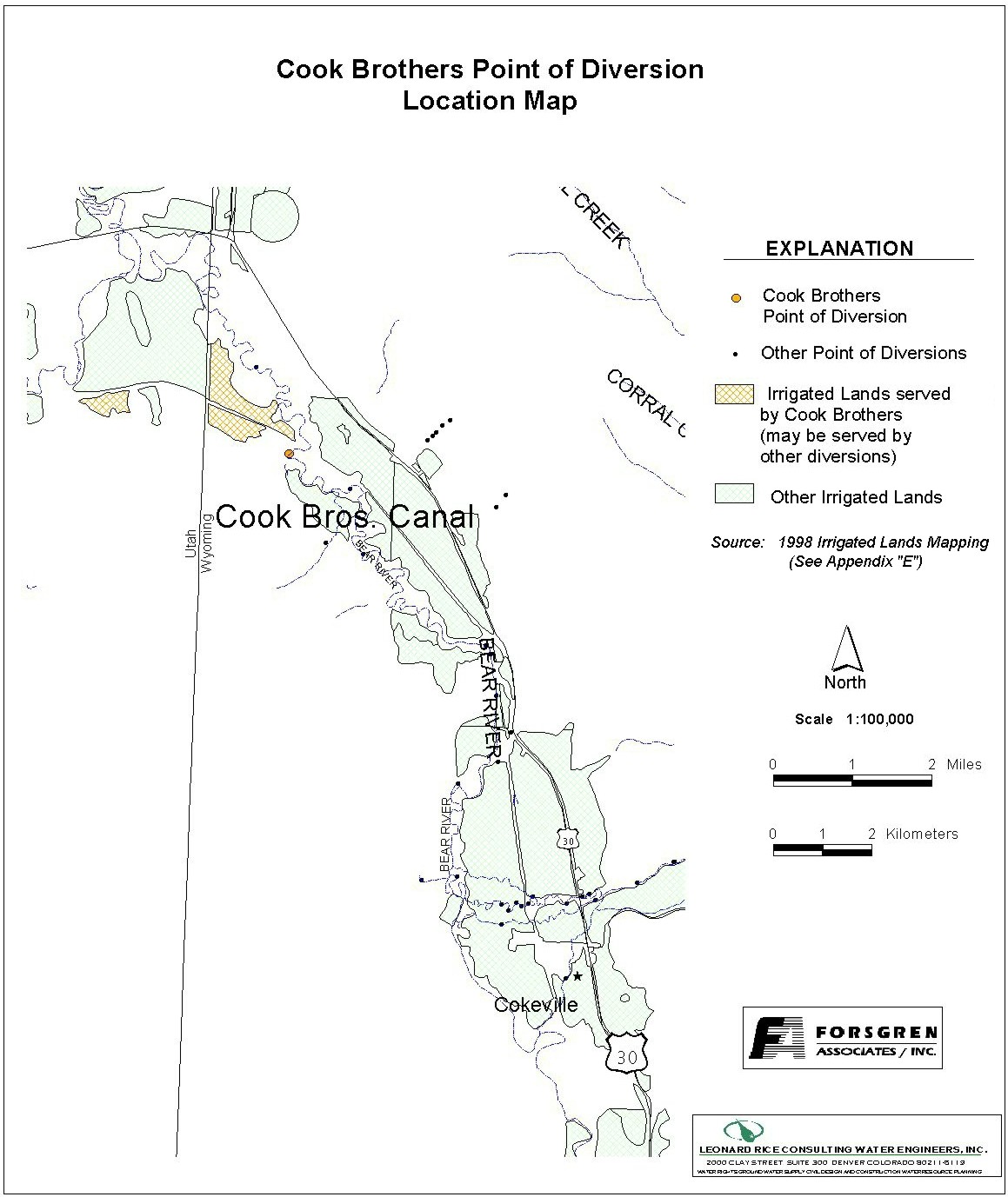
Appendix D Key Structures and Diversions COOK BROTHERS DIVERSION |
| PREPARED BY: | Bear River Basin Planning Team |
| DATE: | August 7, 2000 |
| Diversion Description: The Cook Brothers headgate structure consists of a concrete chute with three (3) 55-inch rectangular wooden gates. It is fed from a natural meander in the river. | 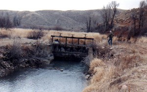 Cook Brothers headgate structure |
|
Conveyance Description: Open channel canal.1
Direct Flow Water Rights:2
| Priority Date | Permit Number |
Permitted Use | Permitted Acres |
Flow (CFS) |
Cumulative (CFS) |
Comments |
|---|---|---|---|---|---|---|
| 05-13-1883 | Terr | Irrigation | 175.89 | 2.51 | 2.51 | |
| 05-13-1883 | Terr | Irrigation, Storage | 60 | 0.85 | 3.36 | |
| 05-13-1883 | Terr | Irrigation, Domestic, Storage | 640 | 9.14 | 12.50 | For irrigation of Idaho lands |
| 05-13-1883 | Terr | Irrigation, Storage | 171.50 | 2.45 | 14.95 | For irrigation of Idaho lands |
| 05-13-1883 | Terr | Irrigation, Storage | 145 | 2.07 | 17.02 | For irrigation of Idaho lands |
| 05-13-1883 | Terr | Irrigation, Domestic, Storage | 1458.22 | 20.83 | 37.85 | For irrigation of Idaho lands |
| 05-13-1883 | Terr | Irrigation, Storage | 243 | 3.47 | 41.32 | |
| 05-13-1883 | Terr | Irrigation, Domestic, Storage | 50 | 0.71 | 42.03 | For irrigation of Idaho lands |
Associated Storage Rights: None
Irrigation Practices: Land is flood irrigated.3
Estimated Diversion Efficiency:
Calculated Diversion Efficiency = Conveyance Efficiency X Application Efficiency:
Conveyance Efficiency: 65% Application Efficiency: 55% Overall Diversion Efficiency: 36% Conveyance efficiency is estimated by total length of main canal. Application efficiency for flood irrigation and sprinkler irrigation is estimated at 55% and 85% respectively.
Crop Types / Consumptive Use: Water is used entirely to irrigate meadow grasses, primarily Timothy, Meadow Foxtail, etc. There is a small percentage of alfalfa and grains.3
Return Flows: Return flow is primarily returned directly to the river and/or Idaho diversions.
The following return flow pattern was adopted for modeling in this study are as follows:
		Month
      (after initial Diversion)	 Percent of Return
		0			70%
		1			20%
		2			10%
                3                        0%
                                       100%
References:
Monthly Diversion Records
Cook Brothers Canal
| YEAR | MAY | JUNE | JULY | AUGUST | SEPTEMBER | ||||||||||
|---|---|---|---|---|---|---|---|---|---|---|---|---|---|---|---|
| Total of Daily Ave for Month | Average CFS |
Monthly Total Ac-Ft |
Total of Daily Ave for Month | Average CFS |
Monthly Total Ac-Ft |
Total of Daily Ave for Month | Average CFS |
Monthly Total Ac-Ft |
Total of Daily Ave for Month | Average CFS |
Monthly Total Ac-Ft |
Total of Daily Ave for Month | Average CFS |
Monthly Total Ac-Ft | |
| 1970 | 0 | 0.0 | 0.0 | 1535 | 51.2 | 3044.6 | 973 | 31.4 | 1929.9 | 533 | 17.2 | 1057.2 | 480 | 16.0 | 952.1 |
| 1971 | 42 | 1.4 | 83.3 | 1143 | 38.1 | 2267.1 | 989 | 31.9 | 1961.7 | 720 | 23.2 | 1428.1 | 1115 | 37.2 | 2211.6 |
| 1972 | 639 | 20.6 | 1267.4 | 1451 | 48.4 | 2878.0 | 527 | 17.0 | 1045.3 | 493 | 15.9 | 977.9 | 627 | 20.9 | 1243.6 |
| 1973 | 222 | 7.2 | 440.3 | 1620 | 54.0 | 3213.2 | 749 | 24.2 | 1485.6 | 237 | 7.6 | 470.1 | 214 | 7.1 | 424.5 |
| 1974 | 673 | 21.7 | 1334.9 | 1653 | 55.1 | 3278.7 | 1253 | 40.4 | 2485.3 | 142 | 4.6 | 281.7 | 864 | 28.8 | 1713.7 |
| 1975 | 0 | 0.0 | 0.0 | 1590 | 53.0 | 3153.7 | 714 | 23.0 | 1416.2 | 440 | 14.2 | 872.7 | 776 | 25.9 | 1539.2 |
| 1976 | 147 | 4.7 | 291.6 | 1641 | 54.7 | 3254.9 | 1111 | 35.8 | 2203.6 | 343 | 11.1 | 680.3 | 154 | 5.1 | 305.5 |
| 1977 | 1188 | 38.3 | 2356.4 | 1059 | 35.3 | 2100.5 | 670 | 21.6 | 1328.9 | 987 | 31.8 | 1957.7 | 381 | 12.7 | 755.7 |
| 1978 | 245 | 7.9 | 486.0 | 1804 | 60.1 | 3578.2 | 1123 | 36.2 | 2227.4 | 750 | 24.2 | 1487.6 | 622 | 20.7 | 1233.7 |
| 1979 | 44 | 1.4 | 87.3 | 155 | 5.2 | 307.4 | 113 | 3.6 | 224.1 | 62 | 2.0 | 123.0 | 51 | 1.7 | 101.2 |
| 1980 | 0 | 0.0 | 0.0 | 1381 | 46.0 | 2739.2 | 728 | 23.5 | 1444.0 | 384 | 12.4 | 761.7 | 669 | 22.3 | 1326.9 |
| 1981 | 1486 | 47.9 | 2947.4 | 1056 | 35.2 | 2094.5 | 589 | 19.0 | 1168.3 | 547 | 17.6 | 1085.0 | 679 | 22.6 | 1346.8 |
| 1982 | 75 | 2.4 | 148.8 | 2103 | 70.1 | 4171.2 | 556 | 17.9 | 1102.8 | 170 | 5.5 | 337.2 | 834 | 27.8 | 1654.2 |
| 1983 | 453 | 14.6 | 898.5 | 2250 | 75.0 | 4462.8 | 481 | 15.5 | 954.0 | 68 | 2.2 | 134.9 | 75 | 2.5 | 148.8 |
| 1984 | 1275 | 41.1 | 2528.9 | 1942 | 64.7 | 3851.9 | 633 | 20.4 | 1255.5 | 6 | 0.2 | 11.9 | 0 | 0.0 | 0.0 |
| 1985 | 301 | 9.7 | 597.0 | 1458 | 48.6 | 2891.9 | 652 | 21.0 | 1293.2 | 349 | 11.3 | 692.2 | 432 | 14.4 | 856.9 |
| 1986 | 587 | 18.9 | 1164.3 | 2105 | 70.2 | 4175.2 | 461 | 14.9 | 914.4 | 340 | 11.0 | 674.4 | 613 | 20.4 | 1215.9 |
| 1987 | 1135 | 36.6 | 2251.2 | 1495 | 49.8 | 2965.3 | 59 | 1.9 | 117.0 | 640 | 20.6 | 1269.4 | 509 | 17.0 | 1009.6 |
| 1988 | 971 | 31.3 | 1926.0 | 1509 | 50.3 | 2993.1 | 335 | 10.8 | 664.5 | 919 | 29.6 | 1822.8 | 299 | 10.0 | 593.1 |
| 1989 | 725 | 23.4 | 1438.0 | 1648 | 54.9 | 3268.8 | 1084 | 35.0 | 2150.1 | 1194 | 38.5 | 2368.3 | 1396 | 46.5 | 2768.9 |
| 1990 | 975 | 31.5 | 1933.9 | 1017 | 33.9 | 2017.2 | 517 | 16.7 | 1025.5 | 382 | 12.3 | 757.7 | 613 | 20.4 | 1215.9 |
| 1991 | 819 | 26.4 | 1624.5 | 1136 | 37.9 | 2253.2 | 497 | 16.0 | 985.8 | 670 | 21.6 | 1328.9 | 1146 | 38.2 | 2273.1 |
| 1992 | 1160 | 37.4 | 2300.8 | 1124 | 37.5 | 2229.4 | 642 | 20.7 | 1273.4 | 844 | 27.2 | 1674.0 | 539 | 18.0 | 1069.1 |
| 1993 | 416 | 13.4 | 825.1 | 1597 | 53.2 | 3167.6 | 677 | 21.8 | 1342.8 | 1276 | 41.2 | 2530.9 | 241 | 8.0 | 478.0 |
| 1994 | 1427 | 46.0 | 2830.4 | 1440 | 48.0 | 2856.2 | 1174 | 37.9 | 2328.6 | 809 | 26.1 | 1604.6 | 526 | 17.5 | 1043.3 |
| 1995 | 1270 | 41.0 | 2519.0 | 1719 | 57.3 | 3409.6 | 732 | 23.6 | 1451.9 | 448 | 14.5 | 888.6 | 596 | 19.9 | 1182.1 |
| 1996 | 1212 | 39.1 | 2404.0 | 1858 | 61.9 | 3685.3 | 689 | 22.2 | 1366.6 | 337 | 10.9 | 668.4 | 1069 | 35.6 | 2120.3 |
| 1997 | 1547.2 | 49.9 | 3068.8 | 1543.1 | 51.4 | 3060.7 | 711.9 | 23.0 | 1412.0 | 387.7 | 12.5 | 769.0 | 576.3 | 19.2 | 1143.1 |
| 1998 | 986.3 | 31.8 | 1956.3 | 2138.7 | 71.3 | 4242.0 | 1064.9 | 34.4 | 2112.2 | 624.7 | 20.2 | 1239.1 | 810.1 | 27.0 | 1606.8 |
| AVERAGES | 23.1 | 1418.2 | 50.8 | 3020.2 | 22.5 | 1383.6 | 16.8 | 1032.1 | 19.6 | 1163.6 | |||||