Wyoming State Water Plan
Wyoming State Water Plan
Wyoming Water Development Office
6920 Yellowtail Rd
Cheyenne, WY 82002
Phone: 307-777-7626

Wyoming Water Development Office
6920 Yellowtail Rd
Cheyenne, WY 82002
Phone: 307-777-7626


| SUBJECT: |
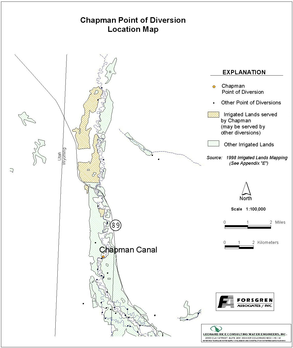
Appendix D Key Structures and Diversions CHAPMAN CANAL DIVERSION |
| PREPARED BY: | Bear River Basin Planning Team |
| DATE: | August 7, 2000 |
| Diversion Description: The headgate structure consists of an older concrete headwall with three 5-foot slide gates. Water is diverted using a driven pile dam structure cemented into the river bottom. | 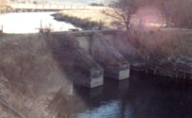 Chapman Canal Diversion |
|
Conveyance Description: Open channel canal, approximately 31,680 feet in length.1
Direct Flow Water Rights:2
| Priority Date | Permit Number |
Permitted Use | Permitted Acres |
Flow (CFS) |
Cumulative (CFS) |
Comments |
|---|---|---|---|---|---|---|
| 10-01-1871 | Terr | Irrigation | 35 | 0.50 | 0.50 | (Bartlett) |
| 10-01-1871 | Terr | Irrigation | 66 | 0.94 | 1.44 | (Bartlett) |
| 10-01-1880 | Terr | Irrigation | 30 | 0.42 | 1.86 | (Morris Irr - Upper) |
| 10-01-1880 | Terr | Irrigation | 64 | 0.91 | 2.77 | (Morris Irr - Upper) |
| 10-01-1880 | Terr | Irrigation | 98 | 1.40 | 4.17 | (Morris Irr - Upper) |
| 10-01-1880 | Terr | Irrigation | 15 | 0.21 | 4.38 | (Morris Irr - Upper) |
| 10-01-1880 | Terr | Irrigation | 15 | 0.21 | 4.59 | (Morris Irr - Upper) |
| 10-01-1880 | Terr | Irrigation | 56 | 0.80 | 5.39 | (Morris Irr - Upper) |
| 10-01-1880 | Terr | Irrigation | 40 | 0.57 | 5.96 | (Morris Irr - Upper) |
| 08-13-1886 | Terr | Irrigation, Storage | 1155 | 16.46 | 22.42 | |
| 08-13-1886 | Terr | Irrigation, Storage | 6892 | 98.46 | 120.88 | 134 CFS state line cap |
| 08-28-1905 | (Utah) | Irrigation, RS, O | 6900 A/F | 134 | 254.88 | (Neponset Reservoir) 134 state line cap |
| 04-12-1912 | 2622E | Irrigation | 40 | 0.57 | 255.45 | |
| 05-03-1912 | 2577E | Irrigation | 285 | 4.07 | 259.52 | 134 CFS state line cap |
| 05-21-1912 | 2593E | Irrigation | 712 | 10.17 | 269.69 | 134 CFS state line cap |
| 02-06-1913 | 2758E | Irrigation | 55 | 0.79 | 270.48 | |
| 02-25-1959 | 6001E | RS? | 19.1 A/F | (Dry Lake Reservoir) 134 CFS state line cap |
Bear River Compact: The Amended Bear River Compact specifically references water rights in the Chapman Canal. Article X of the Compact states:
ARTICLE X
A. The following rights to the use of Bear River water carried in interstate canals are recognized and confirmed.
Name of Canal Date of Priority Primary Right
(Second-feet)Lands Irrigated
(Acres)State Hilliard East Fork 1914 28.00 2644 Wyoming Chapman 8-13-86 16.46 1155 Wyoming 8-13-86 98.46 6892 Wyoming 4-12-12 0.57 40 Wyoming 5-3-12 4.07 285 Utah 5-12-12 10.17 712 Utah 2-6-13 0.79 55 Wyoming 8-28-05 134.00* Francis Lee 1879 2.20 154 Wyoming 1879 7.41 519 Utah * Under the right as herein confirmed not to exceed 134 second-feet may be carried across the Wyoming-Utah state line in the Chapman Canal at any time for filling the Neponset Reservoir, for irrigation of land in Utah and for other purposes. The storage right in Neponset Reservoir is for 6,900 acre-feet which is a component part of the irrigation right for the Utah lands listed above.
Associated Storage Rights:
| Reservoir | Shareholder | Volume (Acre-ft) |
Est. % of Shares Used this Diversion3 | Comments |
|---|---|---|---|---|
| Sulphur Creek | Earl Cook | 17.5 | 100% | |
| Sulphur Creek | Russell Cook | 17.5 | 100% |
Irrigation Practices: Flood Irrigated in Wyoming.3 Estimated Diversion Efficiency:
Calculated Diversion Efficiency = Conveyance Efficiency X Application Efficiency:
Conveyance Efficiency: 50% Application Efficiency: 55% Overall Diversion Efficiency: 27% (Wyoming Portion) Conveyance efficiency is estimated by total length of main canal. Application efficiency for flood irrigation and sprinkler irrigation is estimated at 55% and 85% respectively.
Crop Types / Consumptive Use: Irrigated acreage is primarily meadow grasses with minimal (less than 10%) alfalfa.3
Return Flows: Return flow is ultimately captured by the Woodruff Narrows. Lower Morris Brothers Ditch also captures significant return flow. Flooding problems are reported in the North Uinta County (Town of Bear River) area (approximately 10 miles north of Evanston) when the Chapman Canal is running full.
The following return flow pattern was adopted for modeling in this study are as follows:
		Month
      (after initial Diversion)	 Percent of Return
		0			70%
		1			20%
		2			10%
	                               100%
Other Operational Information: The Chapman Canal is a pre-compact inter-state canal. Utah lands are irrigated using Wyoming water rights. The Bear River Compact limits to flow into Utah to 134 CFS. There is a gaging station at the state line that is typically checked bi-weekly from mid-April to October 1st. The Chapman Canal also delivers water to the Neponset Reservoir.3
References:
Monthly Diversion Records
Chapman Canal (Chapman & Bartlett)
| YEAR | MAY | JUNE | JULY | AUGUST | SEPTEMBER | ||||||||||
|---|---|---|---|---|---|---|---|---|---|---|---|---|---|---|---|
| Total of Daily Ave for Month | Average CFS |
Monthly Total Ac-Ft |
Total of Daily Ave for Month | Average CFS |
Monthly Total Ac-Ft |
Total of Daily Ave for Month | Average CFS |
Monthly Total Ac-Ft |
Total of Daily Ave for Month | Average CFS |
Monthly Total Ac-Ft |
Total of Daily Ave for Month | Average CFS |
Monthly Total Ac-Ft | |
| *1970 | |||||||||||||||
| 1971 | 1895 | 61.1 | 3758.7 | 3825 | 127.5 | 7586.8 | 2191 | 70.7 | 4345.8 | 705 | 22.7 | 1398.3 | 1585 | 52.8 | 3143.8 |
| 1972 | 1839 | 59.3 | 3647.6 | 2990 | 99.7 | 5930.6 | 1470 | 47.4 | 2915.7 | 795 | 25.6 | 1576.9 | 1075 | 35.8 | 2132.2 |
| 1973 | 2447 | 78.9 | 4853.6 | 4462 | 148.7 | 8850.2 | 2835 | 91.5 | 5623.1 | 1767 | 57.0 | 3504.8 | 528 | 17.6 | 1047.3 |
| 1974 | 2790 | 90.0 | 5533.9 | 4332 | 144.4 | 8592.4 | 2290 | 73.9 | 4542.1 | 915 | 29.5 | 1814.9 | 518 | 17.3 | 1027.4 |
| 1975 | 926 | 29.9 | 1836.7 | 4384 | 146.1 | 8695.5 | 4013 | 129.5 | 7959.7 | 420 | 13.5 | 833.1 | 834 | 27.8 | 1654.2 |
| 1976 | 1781 | 57.5 | 3532.6 | 2864 | 95.5 | 5680.7 | 1721 | 55.5 | 3413.6 | 561 | 18.1 | 1112.7 | 486 | 16.2 | 964.0 |
| 1977 | 1033 | 33.3 | 2048.9 | 2476 | 82.5 | 4911.1 | 155 | 5.0 | 307.4 | 122 | 3.9 | 242.0 | 185 | 6.2 | 366.9 |
| 1978 | 1638 | 52.8 | 3248.9 | 4922 | 164.1 | 9762.6 | 1927 | 62.2 | 3822.1 | 656 | 21.2 | 1301.2 | 731 | 24.4 | 1449.9 |
| 1979 | 2713 | 87.5 | 5381.2 | 3160 | 105.3 | 6267.8 | 1012 | 32.6 | 2007.3 | 764 | 24.6 | 1515.4 | 184 | 6.1 | 365.0 |
| 1980 | 2074 | 66.9 | 4113.7 | 3512 | 117.1 | 6966.0 | 1821 | 58.7 | 3611.9 | 779 | 25.1 | 1545.1 | 794 | 26.5 | 1574.9 |
| 1981 | 2689 | 86.7 | 5333.6 | 3390 | 113.0 | 6724.0 | 1184 | 38.2 | 2348.4 | 290 | 9.4 | 575.2 | 638 | 21.3 | 1265.5 |
| 1982 | 2417 | 78.0 | 4794.0 | 4309 | 143.6 | 8546.8 | 2349 | 75.8 | 4659.2 | 138 | 4.5 | 273.7 | 329 | 11.0 | 652.6 |
| 1983 | 668 | 21.5 | 1325.0 | 815 | 27.2 | 1616.5 | 2088 | 67.4 | 4141.5 | 124 | 4.0 | 246.0 | 98 | 3.3 | 194.4 |
| 1984 | 1600 | 51.6 | 3173.6 | 1294 | 43.1 | 2566.6 | 216 | 7.0 | 428.4 | 216 | 7.0 | 428.4 | 120 | 4.0 | 238.0 |
| 1985 | 1726 | 55.7 | 3423.5 | 2576 | 85.9 | 5109.4 | 1124 | 36.3 | 2229.4 | 410 | 13.2 | 813.2 | 294 | 9.8 | 583.1 |
| 1986 | 2217 | 71.5 | 4397.4 | 2802 | 93.4 | 5557.7 | 1525 | 49.2 | 3024.8 | 631 | 20.4 | 1251.6 | 412 | 13.7 | 817.2 |
| 1987 | 2748 | 88.6 | 5450.6 | 2832 | 94.4 | 5617.2 | 980 | 31.6 | 1943.8 | 967 | 31.2 | 1918.0 | 997 | 33.2 | 1977.5 |
| 1988 | 3873 | 124.9 | 7682.0 | 2860 | 95.3 | 5672.7 | 1144 | 36.9 | 2269.1 | 527 | 17.0 | 1045.3 | 258 | 8.6 | 511.7 |
| 1989 | 3663 | 118.2 | 7265.5 | 3555 | 118.5 | 7051.2 | 2823 | 91.1 | 5599.3 | 1122 | 36.2 | 2225.5 | 514 | 17.1 | 1019.5 |
| 1990 | 2556 | 82.5 | 5069.8 | 3858 | 128.6 | 7652.2 | 1524 | 49.2 | 3022.8 | 90 | 2.9 | 178.5 | 58 | 1.9 | 115.0 |
| 1991 | 2981 | 96.2 | 5912.7 | 3785 | 126.2 | 7507.4 | 1262 | 40.7 | 2503.1 | 1319 | 42.5 | 2616.2 | 1170 | 39.0 | 2320.7 |
| 1992 | 3009 | 97.1 | 5968.3 | 2515 | 83.8 | 4988.4 | 1318 | 42.5 | 2614.2 | 213 | 6.9 | 422.5 | 385 | 12.8 | 763.6 |
| 1993 | 2883 | 93.0 | 5718.3 | 5384 | 179.5 | 10679.0 | 2815 | 90.8 | 5583.5 | 964 | 31.1 | 1912.1 | 233 | 7.8 | 462.1 |
| 1994 | 4437 | 143.1 | 8800.7 | 2791 | 93.0 | 5535.9 | 706 | 22.8 | 1400.3 | 136 | 4.4 | 269.8 | 89 | 3.0 | 176.5 |
| 1995 | 4709 | 151.9 | 9340.2 | 6540 | 218.0 | 12971.9 | 3577 | 115.4 | 7094.9 | 670 | 21.6 | 1328.9 | 514 | 17.1 | 1019.5 |
| 1996 | 3412 | 110.1 | 6767.6 | 5197 | 173.2 | 10308.1 | 2194 | 70.8 | 4351.7 | 893 | 28.8 | 1771.2 | 910 | 30.3 | 1805.0 |
| 1997 | 4276 | 137.9 | 8481.3 | 4489 | 149.6 | 8903.8 | 2102 | 67.8 | 4169.3 | 1453 | 46.9 | 2882.0 | 660 | 22.0 | 1309.1 |
| 1998 | 3005 | 96.9 | 5960.3 | 3671 | 122.4 | 7281.3 | 1428 | 46.1 | 2832.4 | 456.3 | 14.7 | 905.1 | 622 | 20.7 | 1233.7 |
| AVERAGES | 83.0 | 5100.7 | 118.6 | 7054.8 | 57.4 | 3527.3 | 20.9 | 1282.4 | 18.1 | 1078.2 | |||||