Wyoming State Water Plan
Wyoming State Water Plan
Wyoming Water Development Office
6920 Yellowtail Rd
Cheyenne, WY 82002
Phone: 307-777-7626

Wyoming Water Development Office
6920 Yellowtail Rd
Cheyenne, WY 82002
Phone: 307-777-7626


| SUBJECT: |
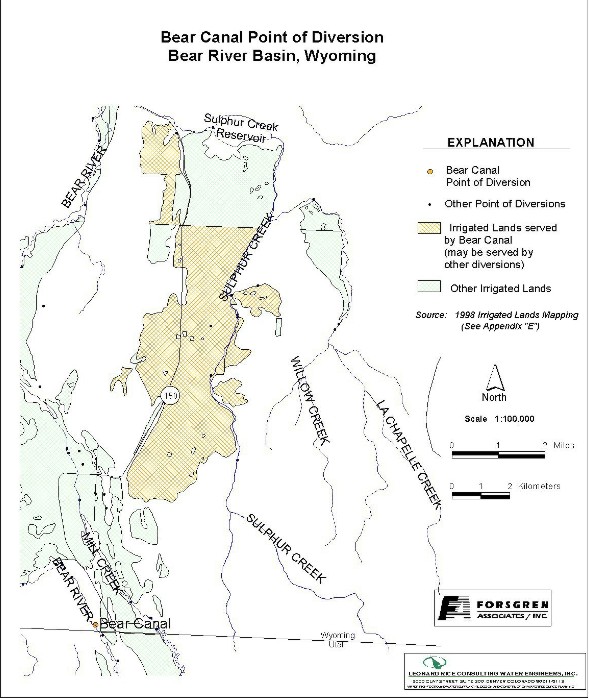
Appendix D Key Structures and Diversions Bear Canal Diversion |
| PREPARED BY: | Bear River Basin Planning Team |
| DATE: | August 7, 2000 |
| Diversion Description: The diversion gate structure consists of a concrete headwall with two 5 foot steel slide gates. Water is diverted from a side channel of the Bear River. | 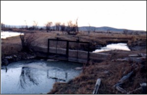 Bear Canal diversion structure |
|
Conveyance Description: Open channel canal, approximately 42,240 feet in length.1
Direct Flow Water Rights:2
| Priority Date | Permit Number |
Permitted Use | Permitted Acres |
Flow (CFS) |
Cumulative (CFS) |
Comments |
|---|---|---|---|---|---|---|
| 05-15-1882 | Terr | Irrigation | 140 | 2.00 | 2.00 | Acocks & Cowlisham |
| Fall-1883 | Terr | Irrigation | 127 | 1.81 | 3.81 | Blight Irr. |
| Fall-1883 | Terr | Irrigation | 10 | 0.14 | 3.95 | Blight Irr. |
| Fall-1883 | Terr | Irrigation | 71 | 1.01 | 4.96 | Blight Irr. |
| Fall-1883 | Terr | Irrigation | 23 | .33 | 5.29 | Blight Irr. |
| 07-20-1885 | Terr | Irrigation | 93 | 1.32 | 6.61 | Coles>Island |
| -1885 | Terr | Irrigation | 70 | 1.00 | 7.61 | Island |
| 08-24-1904 | 6277 | Irrigation | 29 | 0.41 | 8.02 | |
| 08-24-1904 | 6277 | Irrigation | 40 | 0.57 | 8.59 | |
| 08-24-1904 | 6277 | Irrigation | 278 | 3.97 | 12.56 | |
| 08-24-1904 | 6277 | Irrigation | 40 | 0.57 | 13.13 | |
| 08-24-1904 | 6277 | Irrigation | 160 | 2.28 | 15.41 | |
| 08-24-1904 | 6277 | Irrigation | 160 | 2.28 | 17.69 | |
| 08-24-1904 | 6277 | Irrigation | 20 | 0.28 | 17.97 | |
| 08-24-1904 | 6277 | Irrigation | 120 | 1.71 | 19.68 | |
| 08-24-1904 | 6277 | Irrigation | 120 | 1.71 | 21.39 | |
| 08-24-1904 | 6277 | Irrigation | 160 | 2.28 | 23.67 | |
| 08-24-1904 | 6277 | Irrigation | 40 | 0.57 | 24.24 | |
| 08-24-1904 | 6277 | Irrigation | 160 | 2.28 | 26.52 | |
| 08-24-1904 | 6277 | Irrigation | 280 | 4.00 | 30.52 | |
| 08-24-1904 | 6277 | Irrigation | 320 | 4.57 | 35.09 | |
| 08-24-1904 | 6277 | Irrigation | 30 | 0.43 | 35.52 | |
| 08-24-1904 | 6277 | Irrigation | 40 | 0.57 | 36.09 | |
| 08-24-1904 | 6277 | Irrigation | 160 | 2.28 | 38.37 | |
| 08-24-1904 | 6277 | Irrigation | 300 | 4.28 | 42.65 | |
| 08-24-1904 | 6277 | Irrigation | 200 | 2.85 | 45.50 | |
| 08-24-1904 | 6277 | Irrigation | 200 | 2.85 | 48.35 | |
| 08-24-1904 | 6277 | Irrigation | 120 | 1.71 | 50.06 | |
| 08-24-1904 | 6277 | Irrigation | 80 | 1.14 | 51.20 | |
| 08-24-1904 | 6277 | Irrigation | 240 | 3.42 | 54.62 | |
| 08-24-1904 | 6277 | Irrigation | 400 | 5.71 | 60.33 | |
| 08-24-1904 | 6277 | Irrigation | 160 | 2.28 | 62.61 | |
| 08-24-1904 | 6277 | Irrigation | 240 | 3.42 | 66.03 | |
| 08-24-1904 | 6277 | Irrigation | 80 | 1.14 | 67.17 | |
| 05-17-1930 | 4718E | Supplemental Supply | 305.80 | Clark-Titmus (Bazoo Hallow Cr.) | ||
| 05-17-1930 | 4719E | Irrigation | 9.10 | 0.13 | 67.30 | |
| 05-17-1930 | 4719E | Irrigation | 23.80 | 0.34 | 67.64 | |
| 05-17-1930 | 4719E | Irrigation | 25 | 0.36 | 68.00 | |
| 05-17-1930 | 4719E | Irrigation | 15 | 0.21 | 68.21 | |
| 05-17-1930 | 4722E | Irrigation | 154.80 | 2.21 | 70.42 | |
| 05-17-1930 | 4723E | Irrigation | 158.40 | 2.26 | 72.68 | |
| 05-17-1930 | 4725E | Irrigation | 83.10 | 1.18 | 73.86 |
Associated Storage Rights:2
| Reservoir | Shareholder | Volume (Acre-ft) |
Est. % of Shares Used this Diversion3 |
Comments |
|---|---|---|---|---|
| Whitney | Bear Canal | 1102.5 | 100% | |
| Whitney | Brent Barker | 50 | 100% | |
| Whitney | Joe Barker | 100 | 100% | |
| Sulphur Creek | Kyle Lowham | 26 | 50% | By Exchange |
| Sulphur Creek | Carl Lym | 36 | 100% | By Exchange |
| Sulphur Creek | Devan Moss | 50 | 100% | By Exchange |
Irrigation Practices: Land is all flood irrigated.3
Estimated Diversion Efficiency: Canal losses are relatively high due to porous nature of soils in the higher reaches of the Upper Bear.
Calculated Diversion Efficiency = Conveyance Efficiency X Application Efficiency:
Conveyance Efficiency: 40% Application Efficiency: 55% Overall Diversion Efficiency: 22% Conveyance efficiency is estimated by total length of main canal. Application efficiency for flood irrigation and sprinkler irrigation is estimated at 55% and 85% respectively.
Crop Types / Consumptive Use: Water is used entirely to irrigate mixed meadow grasses, primarily Meadow Foxtail, etc.3
Return Flows: Return flow is split between the Sulphur Creek Reservoir (approx. 60%) and Sulphur Creek below the reservoir (approx. 40%).
The following return flow pattern was adopted for modeling in this study are as follows:
              Month
      (after initial Diversion)	 Percent of Return
		0			50%
		1			25%
		2			15%
		3			10%
Other Operational Information: The Bear Canal operates year-round for stock watering in the Hilliard area during the winter months.3
References:
Monthly Diversion Records
Bear Canal
| YEAR | MAY | JUNE | JULY | AUGUST | SEPTEMBER | ||||||||||
|---|---|---|---|---|---|---|---|---|---|---|---|---|---|---|---|
| Total of Daily Ave for Month | Average CFS |
Monthly Total Ac-Ft |
Total of Daily Ave for Month | Average CFS |
Monthly Total Ac-Ft |
Total of Daily Ave for Month | Average CFS |
Monthly Total Ac-Ft |
Total of Daily Ave for Month | Average CFS |
Monthly Total Ac-Ft |
Total of Daily Ave for Month | Average CFS |
Monthly Total Ac-Ft | |
| 1970 | 0.0 | 0.0 | 0.0 | 0.0 | 0 | 0.0 | 0.0 | 0 | 0.0 | 0.0 | 0 | 0.0 | 0.0 | ||
| 1971 | 0 | 0.0 | 0.0 | 1467 | 48.9 | 2909.8 | 2448 | 79.0 | 4855.5 | 828 | 26.7 | 1642.3 | 738 | 24.6 | 1463.8 |
| 1972 | 241 | 7.8 | 478.0 | 2255 | 75.2 | 4472.7 | 1953 | 63.0 | 3873.7 | 432 | 13.9 | 856.9 | 379 | 12.6 | 751.7 |
| 1973 | 366 | 11.8 | 726.0 | 1723 | 57.4 | 3417.5 | 1124 | 36.3 | 2229.4 | 234 | 7.5 | 464.1 | 180 | 6.0 | 357.0 |
| 1974 | 149 | 4.8 | 295.5 | 2662 | 88.7 | 5280.0 | 1366 | 44.1 | 2709.4 | 245 | 7.9 | 486.0 | 403 | 13.4 | 799.3 |
| 1975 | 75 | 2.4 | 148.8 | 1094 | 36.5 | 2169.9 | 1926 | 62.1 | 3820.2 | 745 | 24.0 | 1477.7 | 871 | 29.0 | 1727.6 |
| 1976 | 322 | 10.4 | 638.7 | 1781 | 59.4 | 3532.6 | 770 | 24.8 | 1527.3 | 262 | 8.5 | 519.7 | 223 | 7.4 | 442.3 |
| 1977 | 1024 | 33.0 | 2031.1 | 671 | 22.4 | 1330.9 | 239 | 7.7 | 474.0 | 265 | 8.5 | 525.6 | 255 | 8.5 | 505.8 |
| 1978 | 201 | 6.5 | 398.7 | 2157 | 71.9 | 4278.3 | 1674 | 54.0 | 3320.3 | 212 | 6.8 | 420.5 | 726 | 24.2 | 1440.0 |
| 1979 | 442 | 14.3 | 876.7 | 2187 | 72.9 | 4337.9 | 1130 | 36.5 | 2241.3 | 261 | 8.4 | 517.7 | 211 | 7.0 | 418.5 |
| 1980 | 27 | 0.9 | 53.6 | 1584 | 52.8 | 3141.8 | 1608 | 51.9 | 3189.4 | 290 | 9.4 | 575.2 | 395 | 13.2 | 783.5 |
| 1981 | 47 | 1.5 | 93.2 | 1834 | 61.1 | 3637.7 | 947 | 30.5 | 1878.3 | 114 | 3.7 | 226.1 | 378 | 12.6 | 749.8 |
| 1982 | 494 | 15.9 | 979.8 | 1891 | 63.0 | 3750.7 | 1743 | 56.2 | 3457.2 | 467 | 15.1 | 926.3 | 1000 | 33.3 | 1983.5 |
| 1983 | 54 | 1.7 | 107.1 | 237 | 7.9 | 470.1 | 1862 | 60.1 | 3693.2 | 560 | 18.1 | 1110.7 | 328 | 10.9 | 650.6 |
| 1984 | 0 | 0.0 | 0.0 | 841 | 28.0 | 1668.1 | 2304 | 74.3 | 4569.9 | 837 | 27.0 | 1660.2 | 579 | 19.3 | 1148.4 |
| 1985 | 397 | 12.8 | 787.4 | 2079 | 69.3 | 4123.6 | 1207 | 38.9 | 2394.0 | 420 | 13.5 | 833.1 | 285 | 9.5 | 565.3 |
| 1986 | 740 | 23.9 | 1467.8 | 2014 | 67.1 | 3994.7 | 1219 | 39.3 | 2417.9 | 359 | 11.6 | 712.1 | 821 | 27.4 | 1628.4 |
| 1987 | 598 | 19.3 | 1186.1 | 1712 | 57.1 | 3395.7 | 554 | 17.9 | 1098.8 | 97 | 3.1 | 192.4 | 502 | 16.7 | 995.7 |
| 1988 | 1236 | 39.9 | 2451.6 | 1783 | 59.4 | 3536.5 | 1362 | 43.9 | 2701.5 | 184 | 5.9 | 365.0 | 118 | 3.9 | 234.0 |
| 1989 | 598 | 19.3 | 1186.1 | 1712 | 57.1 | 3395.7 | 554 | 17.9 | 1098.8 | 97 | 3.1 | 192.4 | 167 | 5.6 | 331.2 |
| 1990 | 1006 | 32.5 | 1995.4 | 1931 | 64.4 | 3830.1 | 1537 | 49.6 | 3048.6 | 255 | 8.2 | 505.8 | 83 | 2.8 | 164.6 |
| 1991 | 117 | 3.8 | 232.1 | 2989 | 99.6 | 5928.6 | 1600 | 51.6 | 3173.6 | 304 | 9.8 | 603.0 | 444 | 14.8 | 880.7 |
| 1992 | 1346 | 43.4 | 2669.8 | 2061 | 68.7 | 4087.9 | 642 | 20.7 | 1273.4 | 334 | 10.8 | 662.5 | 290 | 9.7 | 575.2 |
| 1993 | 233 | 7.5 | 462.1 | 1838 | 61.3 | 3645.6 | 2258 | 72.8 | 4478.7 | 434 | 14.0 | 860.8 | 232 | 7.7 | 460.2 |
| 1994 | 1210 | 39.0 | 2400.0 | 1821 | 60.7 | 3611.9 | 794 | 25.6 | 1574.9 | 368 | 11.9 | 729.9 | 206 | 6.9 | 408.6 |
| 1995 | 216 | 7.0 | 428.4 | 1426 | 47.5 | 2828.4 | 2118 | 68.3 | 4201.0 | 667 | 21.5 | 1323.0 | 1094 | 36.5 | 2169.9 |
| 1996 | 470 | 15.2 | 932.2 | 2063 | 68.8 | 4091.9 | 1864 | 60.1 | 3697.2 | 207 | 6.7 | 410.6 | 884 | 29.5 | 1753.4 |
| 1997 | 436.3 | 14.1 | 865.4 | 1894 | 63.1 | 3756.7 | 1830.2 | 59.0 | 3630.1 | 262.9 | 8.5 | 521.5 | 406.8 | 13.6 | 806.9 |
| 1998 | 421.3 | 13.6 | 835.6 | 1396 | 46.5 | 2768.9 | 2267 | 73.1 | 4496.5 | 532 | 17.2 | 1055.2 | 920 | 30.7 | 1824.8 |
| 1999 | 388 | 12.5 | 769.6 | 1873 | 62.4 | 3715.0 | 2041 | 65.8 | 4048.3 | 313 | 10.1 | 620.8 | 528 | 17.6 | 1047.3 |
| AVERAGES | 14.3 | 879.2 | 58.6 | 3486.5 | 47.8 | 2937.0 | 11.8 | 724.0 | 15.7 | 933.4 | |||||