The annual Irrigation System Survey Report, which is published by the Wyoming Water Development Commission, provides a summary of information regarding 28 irrigation districts. These districts lie within a portion of what the Wyoming State Engineer's Office designates as Water Division I. Information regarding the irrigation districts within the Pathfinder to Guernsey subbasin as listed in the 2003 Irrigation System Survey Report is represented in the following table.
Irrigation Districts |
Surface source |
Acres in district (total) |
District acres irrigated |
Number of users |
| LaPrele Irrigation District |
LaPrele Creek & Reservoir |
30,000 |
11,462.2 |
106 |
| Bates Creek Reservoir Company |
Bates Creek-Dry Fork & North Fork |
no formal boundaries |
-- |
7 |
| Casper Alcova Irrigation District |
North Platte River |
24,253 |
24,253 |
500 |
| Douglas Water Users |
-- |
-- |
-- |
-- |
| Wagonhound Land and Livestock |
-- |
7,000 |
1,760 |
1 |
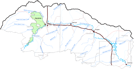
Casper Alcova Irrigation District
The Casper Alcova Irrigation District (CAID) was formed concurrently with establishment of the federal Kendrick Project in the 1930s and 1940s and is located along the north side of the North Platte River between Alcova Dam and the City of Casper, Wyoming. The District diverts water from a headgate at Alcova Reservoir and conveys water to irrigators via the Casper Canal.
The district presently supplies water to 515 farms with 24,250 acres of irrigated lands. Most district irrigation systems employ flood irrigation, and some center pivot and side-roll irrigation systems have been installed recently. The predominant applications of irrigation water in the district are to grow alfalfa and small grains and to irrigate pasture. The district irrigation season typically begins in early May and ends in late September. Recent diversion records show average annual diversions from the headgate at Alcova Reservoir to the Casper Canal ranging from 65,000 to 70,000 acre-feet of water.
Below is a map of the Casper Alcova Irrigation District within the Pathfinder to Guernsey subbasin. Click here to enlarge image, view legend, and to print.