Wyoming State Water Plan
Wyoming State Water Plan
Wyoming Water Development Office
6920 Yellowtail Rd
Cheyenne, WY 82002
Phone: 307-777-7626

Wyoming Water Development Office
6920 Yellowtail Rd
Cheyenne, WY 82002
Phone: 307-777-7626


WIND/BIGHORN RIVERPREPARED FOR THE: |
 |
TABLE OF CONTENTS
|
INTRODUCTION
Authorization
The Wind/Bighorn Basin (WBHB) Plan is one of a series of river basin plans prepared, or currently being prepared, for the Wyoming Water Development Commission (WWDC). The 2001 Wyoming Legislature authorized the Water Development Commission to complete this specific basin plan as part of the overall State Water Plan. River basin plans have been completed for the Bear River Basin, Green River Basin, the Northeast Wyoming River Basins and the Powder/Tongue River Basins. The Snake/Salt River Basin Plan is being completed contemporaneously with the WBHB. The Platte River Basin planning process is scheduled to begin in 2003 and is the final of the basin planning areas. It is the intent of the WWDC that the information presented in the plan documents will be reviewed and updated every five years to reflect changes and new concerns.
Project Scope
The WBHB includes the Wind River, the Clarks Fork of the Yellowstone River and the Bighorn River Basins and focuses on major water uses including: agricultural, municipal, domestic, industrial, environmental and recreational, and water use from storage. This basin plan documents current water uses, surface and ground water availability, and projects future use and/or demand for water, based upon various planning scenarios. In addition, institutional and legal constraints governing water development and management were reviewed and are summarized within this report. Subsequent to the initial scope of work, a review of power generation opportunities in the basin was requested by the WWDC. The power study included both hydropower and power generation from fossil fuels.
Basin Description
The Wind/Bighorn Basin planning area includes all of Bighorn, Park, and Hot Springs Counties, about 95% of Washakie County, approximately 85% of Fremont County, roughly 10% of Teton County, and the entire Wind River Indian Reservation, as shown in Figure I-1. Also included are small, relatively undeveloped portions of northwestern Natrona and western Johnson Counties. Approximately 80% of Yellowstone National Park is included in the planning area. Regionally, the planning area lies within the Missouri River drainage system and covers an area of approximately 20,500 square miles of federal, state, and privately owned land in central and northwestern Wyoming. Only 30%, the Wind River Indian Reservation being considered as non-private land, of the land within the planning area is privately controlled.
Elevations in the planning area are variable because the Wind River and Bighorn Basins are bordered by high alpine mountain ranges. Elevations range from roughly 3,500 feet above sea level, where the Bighorn River crosses the state line into Montana in Big Horn County, to 13,804 feet at the summit of Gannett Peak in Fremont County.
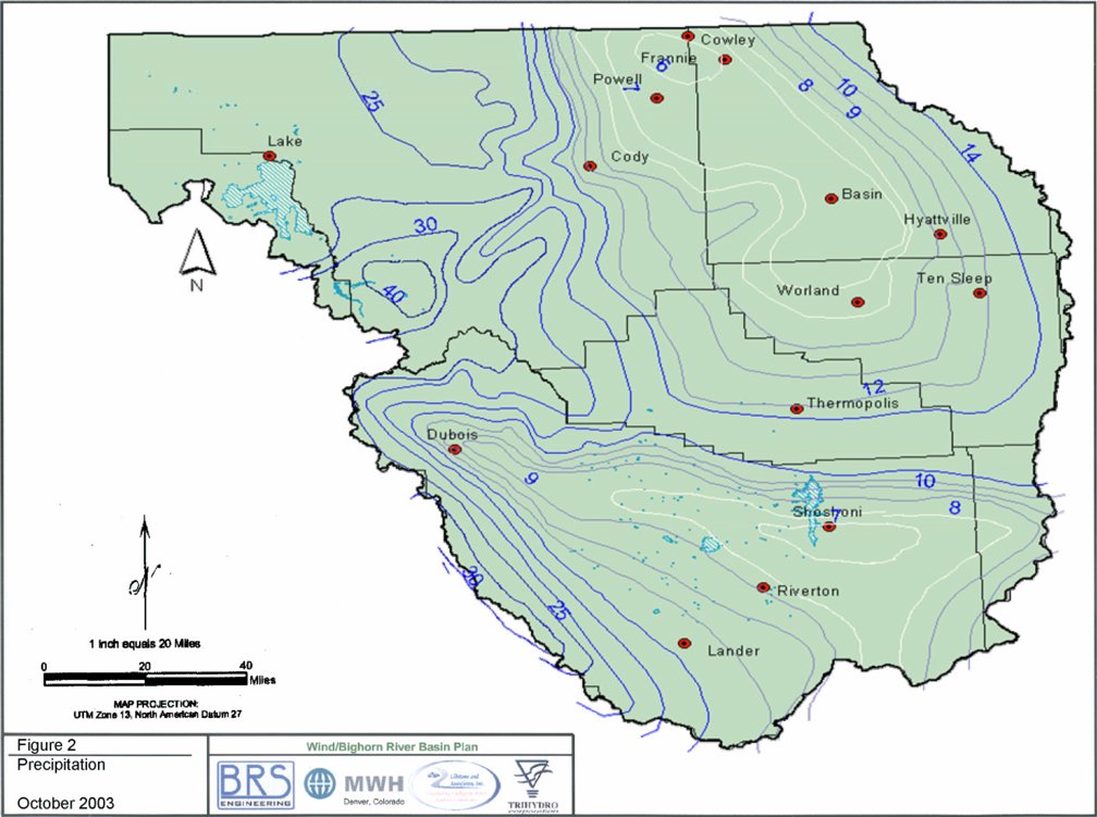
The climate of the planning area varies primarily as a function of altitude and ranges from semi-arid continental in the basin interiors to humid-alpine in the bordering mountain ranges. Annual precipitation varies from 6 to 8 inches in the basin interiors up to 60 to 70 inches along the peaks of the bordering mountain ranges, as shown in Figure I-2. Annual precipitation in the vicinity of Yellowstone National Park ranges from 13 to 70 inches. Most of the planning area receives the majority of its precipitation during the winter as snowfall, but the basin interiors primarily receive precipitation during occasional spring and summer thunderstorms.
There are several reservoirs located within the WBHB area. Capacity of the reservoirs, range from small one acre ponds to the larger reservoirs such as Boysen and Buffalo Bill. These storage facilities play a large role in water utilization within the planning area, as well as being important to down stream water users.
Unique water-related environmental features of the basin include the glaciers of the Wind River mountain range, a section of the Clarks Fork designated as a federal .Wild and Scenic. River, Sink.s Canyon, the Thermopolis Hot Springs, and the numerous natural wonders of Yellowstone Park.
Within the Wind River, Clarks Fork and Bighorn Basins, surface water usage and flow is regulated by the Yellowstone River Compact of 1950 and the GENERAL ADJUDICATION OF ALL RIGHTS TO USE WATER IN THE BIG HORN RIVER SYSTEM (State Engineer.s Office, 1999, http://seo.state.wy.us/).
Previous reports have indicated that some 1,600,000 acre feet per year of surface water in the WBHB and some 424,000 acre feet per year of surface water in the Clarks Fork Basin is unappropriated ( Ostresh, Marston, Hudson, 1990). The findings of this investigation substantially support these figures. However, despite this apparent surplus, many areas within the basins chronically experience water shortages. A challenge is presented to water planners due to the fact that the distribution and availability of the water resources in the WBHB, relative to the point of use, is highly variable.
The Final Report and Technical Memoranda are available through the State Water Plan (http://waterplan.state.wy.us/) in either .PDF format or HTML format. A printed version is available for checkout through the Water Resources Data System (WRDS) library.
References and Additional Information
A substantial portion of information collected and developed as part of this project was developed as a Geographical Information System (GIS) product, which will be managed by WRDS. GIS products include, but are not limited to irrigated lands mapping and water right attribution, topography, climate, geology, hydrologic features and boundaries, and various man-made features such as points of diversion, storage, and distribution. In addition, a surface water model for the entire basin was developed as a spreadsheet model in the format requested by the WWDC. Finally, detailed technical data and descriptions of each component of the basin plan are provided in the Technical Memoranda prepared for this project, as follows:
| BOOK 1 - Chapter I | |||
| Tab 1 | Wyoming Water Law | ||
| Tab 2 | Compacts and Decrees | ||
| Tab 3 | Institutional Considerations and Constraints | ||
| BOOK 1 - Chapter II | |||
| Tab 4 | Agricultural Water Use and Diversion Requirements | ||
| Tab 5 | Wind/Big Horn Lands Mapping and Water Rights Data | ||
| Tab 6 | Municipal Water Use Profile | ||
| Tab 7 | Domestic Water Use Profile | ||
| Tab 8 | Industrial and Mining Water Use | ||
| Tab 9 | Environmental and Recreational Use | ||
| Tab 10 | Water Use From Storage | ||
| Tab 11 | Wind River Range Glaciers | ||
| Tab 12 | Water Conservation in the Wind/Big Horn Basin | ||
| Tab 13 | Reserved | ||
| BOOK 2 - Chapter III | |||
| Tab 14 | Surface Water Hydrology | ||
| Tab 15 | Spreadsheet Model Development and Calibration | ||
| Tab 16 | Available Surface Water Determination | ||
| Tab 17 | Available Ground Water Determination | ||
| BOOK 3 - Chapter IV | |||
| Tab 18 | Socioeconomic Factors and Water Demand | ||
| Tab 19 | Agricultural Water Demand and Projections | ||
| Tab 20 | Municipal and Domestic Water Demand and Projections | ||
| Tab 21 | Industrial and Mining Water Demand and Projections | ||
| Tab 22 | Recreational and Environmental Demand and Projections | ||
| BOOK 3 - Chapter V | |||
| Tab 23 | Future Water Use Opportunities: Screening Criteria | ||
| Tab 24 | Future Water Use Opportunities: Project Summaries | ||
| Tab 25 | Opportunities to Enhance and Protect Water Quality | ||
Addendum . Bibliography of Previous Water Use Studies
Addendum - Irrigation Diversion Operation and Description

(Click on Image to Enlarge)
(Click on Image to Enlarge)
CHAPTER 1 INSTITUTIONAL CONSTRAINTS
1.1 - Wyoming Water Law
Wyoming Water Law is founded on the doctrine of prior appropriation or "first in time is first in right.. This basic premise prevails throughout the statutes. Other basic precepts include:
. Water rights do not convey ownership of waters, but allow for priority use of the water for beneficial purposes.
. Beneficial use is the basis, measure, and limit to the right to use water at all times.
Use of water is administered by the State Engineer and the State Board of Control. The State Board of Control consists of the State Engineer and the superintendents of the four water divsions of the State.
1.2 - Compacts and Decrees
1.2.1 - Introduction
Within the Wind River, Clarks Fork and Bighorn Basins, surface water usage and flow is regulated by: the Yellowstone River Compact of 1950, the GENERAL ADJUDICATION OF ALL RIGHTS TO USE WATER IN THE BIGHORN RIVER SYSTEM, and State of Wyoming, in the District Court, Fifth Judicial District, Civil No. 4993.
1.2.2 - Yellowstone Compact
The interstate compact applicable to the WBHB is the Yellowstone River Compact, which apportions unappropriated flows after 1950 from the Wind River/Bighorn drainage system. The compact between the states of Wyoming, Montana, and North Dakota divides the waters of four tributaries to the Yellowstone River. To all tributaries the following rules apply:
The unappropriated waters in the tributaries, after meeting existing water rights (1950) and supplemental supply for existing rights, as measured at gages near the confluence, are allocated as follows:
| Wind River/Bighorn | 80% Wyoming, 20% Montana |
| Clarks Fork | 60% Wyoming, 40% Montana |
The Yellowstone River Compact is included in the Technical Memorandum, Ch. 1,Tab 2, Appendix A.
1.2.3 - Bighorn General Adjudication
The two million acre Wind River Indian Reservation, located in Fremont and Hot Springs Counties, is also located in the WBHB watershed. The Wind River and many of its tributaries originate on or run through the Reservation, making it an important factor in the WBHB.s water management. The natural resources on the reservation are jointly owned by two tribes, the Shoshone and Arapaho, although some tribal members hold water rights individually. Tribal surface water rights date to 1868, the oldest water rights in the WBHB. Legal proceedings between the State of Wyoming and the Shoshone and Arapaho Tribes awarded the right to 500,000 acre feet of water from the Wind River system to the Tribes. The Wind River Reservation Tribes are allocated surface water annually for beneficial use. Within this allocation, approximately 290,000 acre feet is reserved for future developments on the reservation. Half of the allotment was intended for use in developing new irrigation projects. At the present time, the Tribes cannot beneficially utilize this much water. Downstream users, whose rights are junior to those of the Tribes, are accustomed to having this water available. Working out a management regime that will satisfy all parties is a formidable task. The Reservation not only incorporates within its boundaries private lands not owned by the Tribes, but also operates within a governmental context of tribal, federal, state and local authority and activity. The Bighorn General Adjudication relative to the Wind River Reservation and the Bighorn River system has a distinct impact on future water planning in the WBHB.
A summary of the Bighorn General Adjudication from the Wyoming State Engineer.s Office 1999 Annual Report is included in the Technical Memorandum, Ch. 1, Tab 2, Appendix B.
1.3 - Institutional Considerations
1.3.1 - Introduction
Wyoming's culture and economy are largely shaped by the state's natural setting. All three of the state's major industries; mineral production, tourism and agriculture, are natural resource reliant. Much of the state's quality of life is founded on a tradition of easy access to open country rich in wildlife and relatively un-crowded natural vistas. Outdoor activities from skiing to hunting and fishing to off-road four-wheeling are integral to both the culture and economy of the state.
Management of land, water, wildlife and associated resources occurs within a multifaceted context of institutional constraints. Perhaps the most relevant of these constraints is fragmented ownership and control of land and natural resources. In Wyoming in general, about half the land is owned and managed by federal agencies. The management and ownership of the other half is divided among state, county, local and private entities. Given that the headwaters of most Wyoming streams are located on federal lands, federal oversight of water development and management is inevitable. These constraints also apply to the WBHB, where public lands constitute about 70% of the WBHB.s territory.
Those regions of Yellowstone National Park east of the Continental Divide also lie within the WBHB watershed. Management of the waters within Yellowstone National Park falls within the purview of the National Park Service, although it remains the position of the State of Wyoming that national parks in the state need permits from the Wyoming State Engineer.s Office to use water. The Clarks Fork River leaves Yellowstone National Park within Wyoming, and provides water for northern sections of Park County before going north into Montana. Yellowstone National Park draws around three million visitors per year, and three to four hundred thousand of these enter the Park through the East Entrance, west of Cody.
1.3.2 - Land Ownership
In the WBHB, the Wyoming pattern of diverse land ownership is carried to the extreme, the majority of the WBHB's 14.1 million acres is publicly owned, 63% by the federal government. See Table 1.3-1 for a detailed listing of land ownership. Privately owned land totals nearly three million acres, the Bureau of Land Management alone controls about 4.3 million acres in the WBHB, while the Forest Service owns more than 2.9 million acres. Other federal agencies controlling large areas include the National Park Service and the Bureau of Reclamation. Much of Yellowstone National Park is in the WBHB, and there are wilderness areas in the national forests (Bighorn and Shoshone) in the mountains. Bighorn Canyon, where the Bighorn River leaves Wyoming for Montana, is a national recreation area. Federal agencies play a major role in the what, when, where, how and why of water management and development. The necessity of dealing with diverse land ownership can complicate water development planning.
Table 1.3-1: Land Ownership in WBHB (acres)
| County | Bureau of Indian Affairs | Federal | Private | State | Water | Total |
| Hot Springs County | 220,948 | 542,728 | 433,262 | 84,736 | 3,056 | 1,284,730 |
| Natrona County | 0.00 | 136,301 | 152,828 | 38,217 | 0 | 327,346 |
| Park County | 0.00 | 3,548,712 | 746,760 | 159,546 | 0 | 4,455,018 |
| Washakie County | 0.00 | 941,213 | 351,300 | 98,044 | 1,324 | 1,391,881 |
| Fremont County | 1,323,871 | 2,083,832 | 977,048 | 159,732 | 42,161 | 4,586,644 |
| Bighorn County | 0.00 | 1,616,215 | 328,184 | 72,879 | 2,551 | 2,019,829 |
| WBHB | 1,544,819 | 8,869,001 | 2,989,382 | 613,154 | 49,092 | 14,065,448 |
(All County/Landownership area calculations based on data projected to UTM, Zone 12, NAD27. The Landownership file was acquired from the BLM, its scale is 1:24,000.)
Table 1.3-2 Percent Land Ownership in the WBHB
| County | Bureau of Indian Affairs | Federal | Private | State | Water | |
| Hot Springs County | 17.2% | 42.2% | 33.7% | 6.6% | 0.3% | |
| Natrona County | 0.0% | 41.6% | 46.7% | 11.7% | 0.0% | |
| Park County | 0.0% | 79.6% | 16.8% | 3.6% | 0.0% | |
| Washakie County | 0.0% | 67.6% | 25.2% | 7.0% | 0.2% | |
| Fremont County | 28.9% | 45.4% | 21.3% | 3.5% | 0.9% | |
| Bighorn County | 0.0% | 80.0% | 16.2% | 3.6% | 0.2% | |
| WBHB | 11.0% | 63.0% | 21.3% | 4.4% | 0.3% |
(Percents based off of Table 1.3-1 Land Ownership in the WBHB)
1.3.3 - Wyoming Water Development
The Wyoming Water Development Program was established in 1975, with a mandate to foster, promote, and encourage the optimal development of the state.s human, industrial, mineral, agricultural, water and recreation resources....The program shall encourage development of water facilities for irrigation, for reduction of flood damage, for abatement of pollution, for preservation and development of fish and wildlife resources, for protection and improvement of public lands, and shall help make available the water of this state for all beneficial uses, including but not limited to municipal, domestic, agricultural, industrial, instream flows, hydroelectric power and recreational purposes, conservation of land resources and protection of the health, safety and general welfare of the people of the State of Wyoming. The Wyoming Water Development Commission (WWDC), was established in 1979 to implement the water development program, set goals, provide technical support, and to offer grants and loans to public entities for construction projects directly related to water needs.
Wyoming statutes do not require that publicly funded water development projects include provision for instream flows. However, the WWDC, through its founding legislation, is able to consider instream flows, though it is not mandatory in every case. Under Wyoming law, only the state can hold Instream Water Rights.
The presence of threatened or endangered wildlife species is a trigger for instream flow consideration or action by the state. Examples of fish species that seem to be under pressure are the Yellowstone Cutthroat Trout in the western drainages of the WBHB, and sauger and sturgeon chubs in the Bighorn River. State action initiatives can simplify remedial actions that might be made more complex by federal intervention. However, 94% of the more than 9.4 million acres of public land in the WBHB is federally owned, so federal involvement or participation is likely in most water projects of any size.
Other state agencies involved in water management include the State Engineer.s Office (SEO), the Department of Environmental Quality (WDQ-DEQ), the Wyoming Game and Fish Commission (WGFC) and the Wyoming State Parks and Cultural Resources Department. Water rights are administered by the State Engineer.s Office.
1.3.4 - Impact of Environmental and Cultural Concern on Regulation and Legislation
During the last four decades, a rising concern about the condition of the physical environment has sparked many regulatory initiatives. A much broader spectrum of value is now applied to natural entities, including the delineation of "existence. or "passive. uses of natural amenities. Numerous environmental activist groups now exist, seeking a voice in policy-making, and use econometric methods to enable comparisons of intangible benefits attached to natural phenomena. The rise of these advocacy groups has moved other types of interest groups to be more active in areas of environmental and development policy.
Along with the growing environmental concerns, there is a growing concern about historic, archaeological, and cultural sites. As a consequence, surveys to determine effects of development projects on cultural values are necessary. The Cultural Resources Division of the Department of State Parks and Cultural Resources provides surveys of areas to ascertain whether or not cultural resources might be put at risk.
These factors have played a role in producing more active participation in public land, water, and wildlife policy-making and management than was observed in the past. In response to this political evolution, since the late 1960.s, government at all levels has proliferated studies, laws, regulations, and policies aimed at environmental protection. Water development must incorporate a variety of needs including agricultural, industrial, municipal, domestic and recreational uses. At the same time, the relevance of ecological values in policy-making has greatly expanded. One consequence of increased and widespread public concern, beyond whatever ecological or cultural benefits may be produced, is an increase in the complexity, cost, and time required to evaluate, plan, fund, carry out, and maintain projects. Perhaps the most obvious consequence of this trend is the increasing range, number, and complexity of laws, regulations, agencies, and policies governing water use and development, adding to the overall complexity in water management.
1.3.5 - Environmental Legislation
Prior to 1948, the federal government.s role in water pollution regulation was minimal. However, in 1956 the federal government began to assume primary responsibility for water quality (Freeman, 1991). Since then, federal and state legislation and regulation have created many constraints for water and water-related development efforts. A broader spectrum of issues exist and water development projects are not necessarily driven primarily by consumptive needs. A change of emphasis from "wise use. to "conservation. and then toward "preservation. has occurred, carrying many implications for water planning and development. The consequence is higher levels of costs and longer time periods for planning and construction. Almost all water development actions fall under the purview of federal environmental laws and the agencies that administer them. The WWDC has reported (Wyoming Water Development Commission, "2002 Legislative Report, Situation Analysis., http://wwdc.state.wy.us):
Major national environmental legislation pertinent to water management and development includes the National Environmental Policy Act (NEPA), the Clean Water Act (CWA) and the Endangered Species Act (ESA). These three laws (first enacted in 1969, 1972, and 1973, respectively) are the source of most federal authority for regulating water and the ecosystems relevant to water supply and quality. Agency rules, regulations, and policies are derived from these congressional roots. The headwaters of most WBHB streams are within the boundaries of U.S. Forest Service or Park Service lands and most reservoirs are managed by the U.S. Bureau of Reclamation. Other federal agencies, such as the U.S. Department of Agriculture.s Natural Resource Conservation Service, are concerned with riparian areas, crop and pasture land. Outside the national parks, wildlife management, including fisheries, is within the domain of the WGFC, although the U.S. Fish and Wildlife Service plays a major role in issues involving threatened, endangered, migratory species and threatened habitat.
Federal environmental protection laws are very inclusive in their reach. The Endangered Species Act (1973), for instance, covers both animal and plant species and requires that the Department of the Interior, often through the U.S. Fish and Wildlife service, determine whether or not an action may affect some species. No federal agency can take any action deemed threatening to any endangered or threatened species, or any "sensitive. species such as raptors. These laws require that project planners avoid or minimize impacts viewed as ecologically negative. Most judgments are vested in lead agencies, the U.S. Fish and Wildlife Service for the ESA and the U.S. Corps of Engineers for the CWA. NEPA is a broad piece of legislation, requiring compliance with federal agencies and regulations for all proposed projects.
As noted in the WWDC Green River Basin Plan, the "only water development activity not subject to federal environmental laws is drilling a well with non-federal funds on non-federal lands outside the banks of rivers, streams, and wetlands. However, piping the water from such wells across federal lands or rivers, streams and wetlands could initiate a federal environmental review. (Purcell, 2001). Any project involving public lands requires special use and right-of-way permitting, and ecological reviews will be required in most cases. In cases where an Environmental Assessment finds that there are no serious issues involved, an Environmental Impact Statement may not be necessary, expediting the process. This national legal and institutional framework means that any Basin water project will be reviewed by multiple agencies, unless the proposal is a very clear cut and unmistakably beneficial. Considerations such as water quality, instream flows, riparian habitat, threatened or endangered species and human access are particularly pertinent within the WBHB.
In Park County.s Shoshone National Forest, a 20-mile reach of the Clarks Fork River running through a deep canyon, is Wyoming.s only federally designated Wild and Scenic river. The Wild and Scenic status severely limits development possibilities. Other WBHB waters, outside of Yellowstone National Park, that have been mentioned as deserving protected status include the Porcupine drainage in Big Horn County, the Shoshone River within the Bighorn Canyon National Recreation Area, and the Wiggins Fork in Fremont County (U.S. National Park Service, Nationwide Rivers Inventory, http://www.nps.gov). These streams could be considered for inclusion under several categories: wild and scenic or recreational. However, none of them have yet to reach candidate status.
1.3.6 - Water Development Projects and Proposals
In arid Wyoming, water tends to be somewhat scarce and therefore a valuable and controversial commodity. Proposed projects must receive broad support if they are to be funded and implemented. Since the foundation of Wyoming Water Law is the doctrine of prior appropriation, junior rights may not be entitled to divert water until senior rights are satisfied. This means that the first water management issue to be resolved is whether or not there is adequate water available for junior uses under a worst-case scenario. If it is thought likely that in dry years the water supply could be inadequate, then consideration needs to be given to the possibility of building storage facilities. As a project study proceeds, legal, institutional, and economic issues are identified. An important factor may be whether or not additional benefits, such as environmental or recreational opportunities, are there to strengthen the project. The evaluation completed, the overall economic feasibility of a proposed project can be assessed.