Wyoming State Water Plan
Wyoming State Water Plan
Wyoming Water Development Office
6920 Yellowtail Rd
Cheyenne, WY 82002
Phone: 307-777-7626

Wyoming Water Development Office
6920 Yellowtail Rd
Cheyenne, WY 82002
Phone: 307-777-7626


The Irrigated Lands and Water Rights GIS dataset is the most important, and complex, of the GIS themes produced in conjunction with the seven river basin plans. The dataset consists of:
Another relationship was established between the PODs and the water right permits. This is also a many-to-many relationship. One physical POD (e.g. headgate) may have more than one permit associated with it. It is also possible, although less common, for a single water right permit to have multiple PODs (e.g. sprinkler systems).
By employing both of these relationships, it is possible to relate PODs and irrigated polygons.
Although all seven basin plans used similar techniques to capture the data, there is considerable variation between plans in how the data is modeled, related, and presented. This is discussed in more detail in the following section.
SOURCE DATA OVERVIEW
There are significant differences in the modeling of this data between the seven basin plans, particularly in the schema of the database relationships. Four different types of relational models were used in the basin plans. These relational models are shown in the Entity Relationship (ER) diagrams throughout this memo.
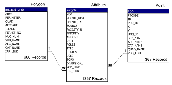
Four of the basin plans organized this GIS data into a normalized relational model using four tables:
A "linking" table is always required in many-to-many relationships. A simple example below illustrates the role of the linking table:
Many-to-Many relationships
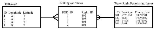
All records in the POD table are unique; there is only one record/point per POD. All records in the Water Rights Permits table are unique; there is only one record per permit. There is a one-to-many relationship between the POD table and the linking table, and there is a one-to may relationship between the Water Right Permits table and the linking table. Thus a many-to-many relationship is established between the PODs and the Permits.
The four table model is slightly more complex than the simple linking table example above. The linking table is used to establish the many-to-many relationship between three tables (irrigated polygons, PODs, and permits) and thus has three columns. The four table model is illustrated in the Northeast River Basins ER diagram below.
Northeast Rivers (Powder, Platte and Wind/Bighorn are similar)
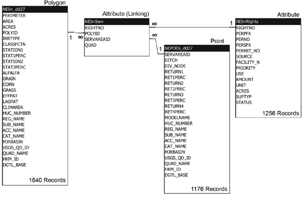
This four table model is the most rigorous of the various data models used in the basin plans, and it was used in four of the seven basin plans, therefore it was selected as the model for the statewide coverage. Data from the three basin plans that did not use this model (Bear, Green, Snake/Salt) was reformatted and normalized to conform to the four table model. This was a significant effort and is detailed below for each river basin.
Bear River Basin Data Normalization
The irrigated land polygons were supplied in both shapefile and E00 format. The shapefile data were digitized at a much finer level of detail. The E00 data was not used.
The ER diagram below shows the source tables, attribute fields, and relationships. Water rights permit attribute data is stored in a single table and related to the polygons by a spatial join (point in polygon) and related to the PODs by a shared key column.
Bear River Basin
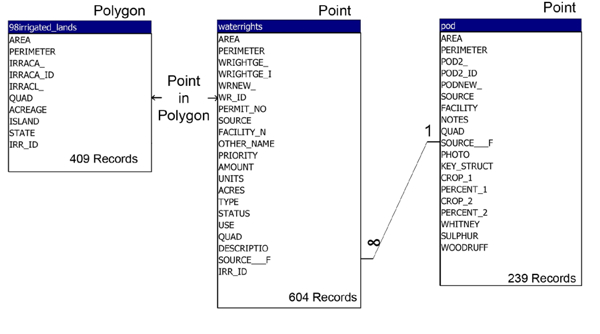
Water right permits were represented in a spatial table as point objects. The points were simply placed within an irrigated polygon and had no other spatial significance. (per Heather Justice, Leonard Rice Consulting 8/28/2006)
Irrigated polygons were split on 7½ minute quad boundaries. In some instances this created sliver polygons that did not have any attribute data (they had no permit table point within them). In other instances, duplicate water right permit points were placed in each .half. of a split polygon. Therefore, the 7½ minute quad boundaries were dissolved for the state-wide coverage.
A polygon ID field was added to the water right permits table and was updated with the polygon ID of the irrigated polygon containing each permit point. Spatial objects were then dropped from the water right permits table. Identical permits within the same polygon were deleted. Some duplicate permits do still exist where the permit serves more than one polygon.
The POD table is related to the Permits table by the SOURCE_F field, which is a concatenation of the SOURCE and FACILITY_NAME fields.
Green River Basin Data Normalization
The Green River Basin data consists of three tables shown in the ER diagram below. Like the Bear River, Permits were represented as point objects within irrigated polygons. Also like the Bear River, irrigated polygons were split on 7½ minute quad boundaries. Unlike the Bear River relational model, the POD water right permit data was not stored in the same table as the irrigated polygon permits. Thus permits were duplicated in the POD table and the polygon attribute table.
Green River Basin
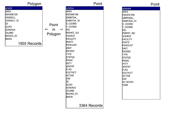
Polygon processing: The 7½ minute quad boundaries in the irrigated polygons were dissolved. A POLY_ID field was created in the irrigation permits table and populated with a unique irrigated polygon ID based on the point-in-polygon relationship (same technique as Bear, above). Spatial objects were dropped from the irrigation permits table.
POD processing: Each POD permit had a point object, thus a single physical POD (e.g. headgate) was usually represented by multiple points (one for each permit). The PID field identified unique physical PODs. The POD permits table was split into a spatial table and an attribute table, which are related by PID. Duplicate points objects were deleted so that the PID was unique in the spatial table.
Permit processing: At this point we had two water right permit attribute tables; the irrigation permits (related to the irrigated polygons) and the POD permits (related to POD points) and the two tables contain duplicate permits. The two tables were merged into a single table of unique permits. Unique permits were identified by PERMIT_NO for non-territorial water rights, and by a combination of DATE, SOURCE, FACILITY, and PAMOUNT fields for territorial permits. Relationships to the irrigated polygon table and POD point table were preserved in the linking table.
Snake/Salt River Basin Data Normalization
The Snake/Salt River Basin data model was very similar to the four-table model selected for the state-wide coverage; spatial objects in the irrigated lands and POD tables are linked to a shared attribute table of water right permits. The main work required to normalize the data was to separate the key fields into a separate linking table.
The source data model is shown in the ER diagram below.
Snake and Salt River Basins
Wind/Bighorn River Basin Notes
The irrigated land polygons within the Wind River Indian Reservation were developed by the Wyoming State Engineer's Office and States West Water Resources Corporation in conjunction with the 1982 Bighorn River General Adjudication. Water rights were granted as a result of this action. These water right polygons were classified as .Water Awards. in the Wind/Bighorn (WB) river basin GIS data, however no distinction was made between irrigated and un-irrigated land. The un-irrigated land within the Water Awards is referred to as "Tribal Futures" in the Basin Final Report, but could not be identified in the GIS data.
Nancy McCann, Wyoming State Engineer's Office, provided a "futures" shape file which does
identify un-irrigated land within the Water Awards. All polygons in the original WB GIS layer
falling within futures shape file polygons were reclassified as "un-irrigated tribal futures water awards".
The only modification of the original data was the change of the CLASSCTN attribute value from "Water Awards" to "un-irrigated tribal futures water awards". These polygons still link to the
water right permits table as they have valid water rights. However these polygons can be excluded
from analysis by filtering on the CLASSCTN column.