Wyoming State Water Plan
Wyoming State Water Plan
Wyoming Water Development Office
6920 Yellowtail Rd
Cheyenne, WY 82002
Phone: 307-777-7626

Wyoming Water Development Office
6920 Yellowtail Rd
Cheyenne, WY 82002
Phone: 307-777-7626


| SUBJECT: |
Appendix J Storage Operation and Description |
| PREPARED BY: | HKM Engineering Inc. |
| DATE: | March 2002 |
INTRODUCTION
In accordance with the scope of services, an inventory of the storage facilities located within the Powder River and Tongue River Basins was completed. This inventory is intended to be used for future planning and to provide information for water availability modeling of the basins. After consulting with State Engineer's Office personnel, HKM composed technical reports on 14 reservoirs considered significant to the basin. In addition, HKM developed summaries for 189 reservoirs detailing their tributaries, capacities, locations, and corresponding evaporative rate per year. These data comprise an effective backbone for the modeling work to follow.
Because reservoir operations are changing rapidly in the Powder/Tongue River Basin, the storage operations memorandum will probably demand updating more than most other elements of the plan. Coal Bed Methane (CBM) produced waters have been contained for the most part in small stock pond-like facilities, but larger facilities are being considered in this basin just as they are farther to the east.
STORAGE FACILITIES SELECTION
The initial selection of storage to be inventoried was based on a review of the Safety of Dams Active Dams database. As per requests from the State Engineer's Office and Wyoming Water Development Commission personnel, all surface water storage in structures containing more than 50 acre-feet of storage or more than 20 feet high (meeting the minimum standards for inclusion in the Dam Safety database) were selected. These selection criteria produced a set of 189 surface water storage facilities. The statistics for each of these reservoirs are presented in the summary tables following the 14 detailed reports.
State Engineer's Office Water Division Two commissioners agreed that a further set of criteria should be introduced to provide a list from which the dams of particular significance to the basin could be developed. Commissioners agreed that in almost all cases, a limit of 1,000 acre-feet capacity and "serving multiple users" produced a list of reservoirs significant to the basins. The only recommended exception was Cross Creek Reservoir, which has a normal capacity of 798 acre-feet. This inclusion brought the secondary selection list to 14.
The list of these storage facilities was submitted to the superintendent and water commissioners for verification. Individual memoranda were developed providing more detailed operational information for these significant facilities.
METHODOLOGY
Base Data
The information provided in the 14 in-depth reports and the 189 summaries that follow comes primarily from the State Engineer's Office's (SEO) Safety of Dams Active Dams database. This is also the primary reference tool for SEO personnel inspecting dam safety around the state. Some data are not available in that database. Associated water right information had to be culled from the SEO Tab Books in Water Divisions I and II. Operational details were gleaned from interviews. Area-capacity tables, illustrations, and pictures often came from SEO Division II files or Safety of Dams office records.
Unfortunately, these sources do not agree on all points. For instance, Kearney Lake has an active capacity of 6,324 acre-feet according to the Safety of Dams Active Dams database, but only 6,130.55 acre-feet can be released from the dam, according to an area-capacity table on file in the SEO's Water Division II office in Sheridan, Wyoming. Similar discrepancies can be found comparing these data to water rights.
It is not within the scope of this study to resolve these conflicts. As much information as possible was provided for each of the 14 significant reservoirs. In general, when the source is other than the Safety of Dams Active Dams database, the source is noted.
Finally, data in this memorandum are presented as they are found in the original sources. Terminology, references, and notes are unchanged.
The following definitions provided by the U.S. Bureau of Reclamation provide a brief definition of key terms:
Active capacity. The reservoir capacity normally usable for storage and regulation of reservoir inflows to meet established reservoir operating requirements. It extends from the highest of either the top of exclusive flood control capacity, the top of joint use capacity, or the top of active conservation capacity, to the top of inactive capacity. It is also the total capacity less the sum of the inactive and dead capacities. The reservoir capacity that can be used for irrigation, power, municipal and industrial use, fish and wildlife, recreation, water quality, and other purposes.Data Gathering for Storage Evaporative LossesNormal water surface. The highest elevation at which water is normally stored, or that elevation which the reservoir should be operated for conservation purposes. Usually the elevation at the top of the active conservation capacity. The maximum elevation to which the reservoir may rise under normal operating conditions exclusive of flood control capacity.
Total capacity. The reservoir capacity below the highest of the elevations representing either the top of exclusive flood control capacity, the top of joint use capacity, or the top of active conservation capacity. In the case of a natural lake which has been enlarged, the total capacity includes the dead capacity of the lake. Total capacity is used to express the total quantity of water which can be impounded and is exclusive of surcharge capacity.
To understand how much water is lost to reservoir evaporation throughout the basin, it was necessary to correlate the reservoir locations in the State Engineer's Office Tabulation of Adjudicated Surface Waters for Divisions one and two (where applicable) and the Safety of Dams Active Dams database with values from the Annual Lake Evaporation Map in Larry E. Lewis' Development of an Evaporation Map for the State of Wyoming for Purposes of Estimating Evaporation and Evapotranspiration. This cross-correlation produced an annual loss value (in inches of water). This was then multiplied by the factors in Lewis' Table VIII, "Pathfinder Dam Annual Evaporation Distribution" to produce monthly gross evaporation in inches. The values for the months of May-September were summed, and the result was multiplied by the factors in Table IX, "May Through September Monthly Evaporation Distribution." These calculations yielded the monthly values provided in the summary tables.
Though Lewis' work was completed in 1978, and the more recent NOAA Technical Report NWS: Evaporation Atlas for the Contiguous 48 United States would seem like a better choice for its 1983 vintage, Lewis' work contains far more data from Wyoming. Lewis also worked with approximately as much data as is available today to compile his maps, rejecting data points on field inspection, and still had a much larger data set and one of greater duration (20 years compared with 15) than the national study draws upon.
For more detailed information, water commissioners, Safety of Dams personnel, landowners, operators, and officials familiar with the reservoirs were consulted. The documentation accompanying permits or applications for enlargement yielded the most data.
Calculations for Gross Storage Evaporative Losses
Once the Lewis evaporation numbers were obtained (inches), they were multiplied with the water area (acres) exposed to the atmosphere in an average month. To do this, HKM collected the available end-of- month storage records for the significant reservoirs identified earlier. In the case of the Powder/Tongue River Basin, records existed for Twin Lakes, Tie Hack, Healy, and Lake DeSmet reservoirs. Once an average end-of-month volume or elevation was computed for each, it was correlated with the area- capacity table to generate a corresponding end-of-month surface area in acres. Subsequent calculations can generate the gross evaporative loss in acre-feet per month:
LossGross(acre-ft)= Lewis(in.) X Area(acres)
                       12(in./ft)
Calculation of Net Evaporative Losses in Storage
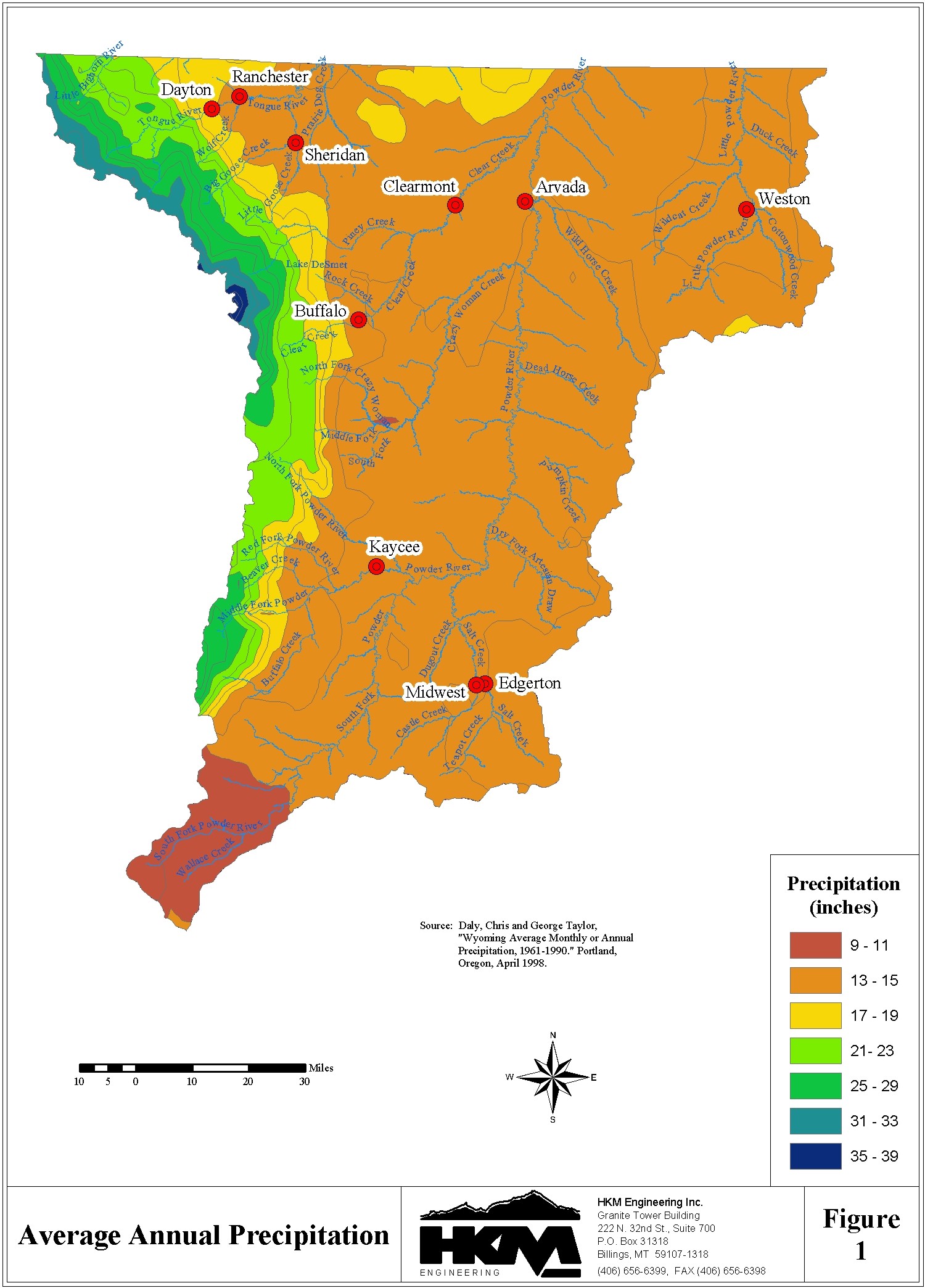
Evaporative loss in storage isn't a simple, one-way dynamic; the same acreage of water that is exposed to the atmosphere for evaporative losses is also exposed to precipitation. To understand the net effect of these two factors, precipitation must be subtracted from the evaporative losses. This changes the calculation above in only one respect:
LossNet(acre-ft)=[Lewis(in.) - Precip(in.)]x Area(acres)
                               12(in./ft)
This study depends on the precipitation mapping completed by Oregon State University in its Parameter-
elevation Regressions on Independent Slopes Model (PRISM), which generated gridded estimates of
climate parameters from historical meteorological data collected 1961-1990. The applicability of this
model to mountainous terrain made it particularly apt for this basin. (See
http://www.ocs.orst.edu/prism/overview.html for more information.) Because the PRISM data are
available in a GIS format, the locations of the facilities were loaded into the same GIS to produce a
corresponding monthly precipitation estimate. Figure 1 illustrates the average annual precipitation depths
from PRISM.
The net evaporative loss estimates are provided below the end-of-month storage summaries behind each overview of key storage facilities.
Evaporative Losses from Storage for Remaining Facilities
HKM divided total capacity for each of the four facilities with available end-of-month data in this basin by those monthly readings. This produced a percentage of total storage for each of the four facilities with data at the end of each month; these were averaged. For each facility with no end-of-month storage data, the average end-of-month percentage of total storage was multiplied by the facility's total storage, which was then cross-referenced with the area-capacity table to produce an estimated end-of-month area. This number was used to calculate the gross and net evaporative losses as above.
COMPACT ISSUES
The Yellowstone River Compact (1950) contains several restrictions on surface water storage. The Wyoming Water Planning Program Report No. 10: Water & Related Land Resources of Northeastern Wyoming provides an excellent summary of its provisions (pp. 48-51):
Yellowstone River Compact
The Yellowstone River Compact provides a basis for dividing the waters of the Yellowstone River between the States of Wyoming, Montana, and North Dakota. The Yellowstone River Compact was negotiated in 1950 and ratified by the three states and the Federal Government in 1951. The compact establishes a commission composed of one representative each from Montana, Wyoming, and the U. S. Geological Survey to administer its provisions. Article V provides for a division of water on the following basis:
Bighorn River (exclusive of the Little Bighorn River):
Wyoming . . . . . . . . 80% Montana . . . . . . . . 20%
Tongue River:
Wyoming . . . . . . . . 40% Montana . . . . . . . . 60%
Powder River (including the Little Powder River):
Wyoming . . . . . . . . 42% Montana . . . . . . . . 58%
Other provisions of the compact which affect the division and use of Yellowstone River water include:
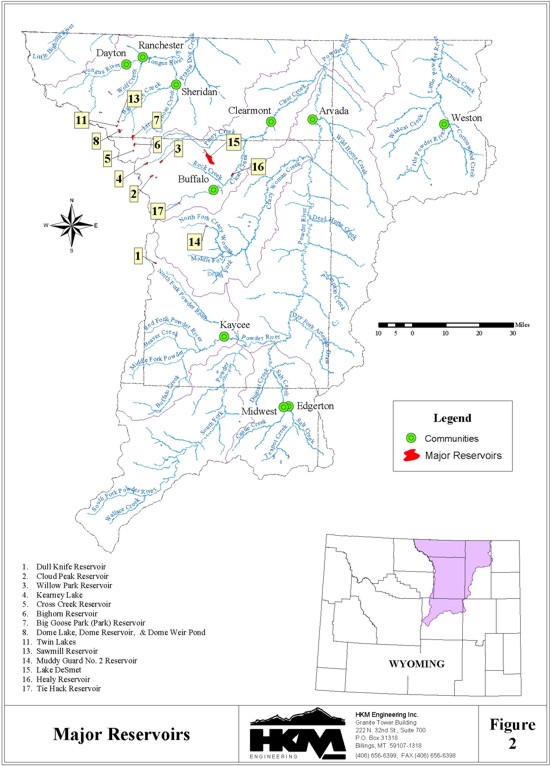
The significant reservoirs detailed in this memorandum are listed in the following table and illustrated in Figure 2:
| Reservoir | Permit | Latitude | Longitude | Year Complete |
Active Capacity (af) |
Dam Height (ft) |
Surface Area (acres) |
Annual Net Evap. Loss (af) |
| BIG GOOSE PARK | 6448R | 44° 34' 0'' | 107° 12' 30'' | 1933 | 10,362 | 85 | 318 | 557 |
| BIG HORN | 6947R | 44° 32' 3'' | 107° 12' 15'' | 1909 | 4,624 | 45 | 179 | 296 |
| CROSS CREEK | 7441R | 44° 29' 52'' | 107° 12' 57'' | 1977 | 798 | 30 | 51 | 278 |
| CLOUD PEAK | 6906R | 44° 24' 11'' | 107° 4' 46'' | 1958 | 3,570 | 36 | 174 | 85 |
| DOME LAKE NO. 1 | 7024R | 44° 35' 30'' | 107° 18' 47'' | 1907 | 1,506 | 30 | 96 | 8,372 |
| DULL KNIFE | 6915R | 44° 1' 10'' | 107° 3' 12'' | 1966 | 4,345 | 80 | 130 | 170 |
| HEALY | 7290R | 44° 24' 18'' | 106° 36' 39'' | 1975 | 5,140 | 50 | 246 | 205 |
| KEARNEY LAKE | 6826R | 44° 27' 17'' | 107° 6' 58'' | 1928 | 6,324 | 67 | 193 | 556 |
| LAKE DESMET | 7009R | 44° 30' 48'' | 106° 46' 30'' | 1921 | 111,827 | 80 | 2653 | 291 |
| MUDDY GUARD NO. 2 |
7598R | 44° 11' 16'' | 106° 45' 11'' | 1976 | 1,934 | 57 | 48 | 113 |
| SAWMILL | 7268R | 44° 37' 32'' | 107° 17' 56'' | 1960 | 1,275 | 38 | 75 | 136 |
| TIE HACK | 9700R | 44° 16' 57'' | 106° 55' 27'' | 1997 | 2,435 | 110 | 63 | 148 |
| TWIN LAKES | 6847R | 44° 36' 36'' | 107° 18' 36'' | 1937 | 1,317 | 54 | 52 | 112 |
| WILLOW PARK | 6408R | 44° 27' 4'' | 107° 1' 48'' | 1959 | 4,457 | 56 | 213 | N.A. |
REFERENCES
Active Dams, State Engineer's Office Safety of Dams Engineering Div. Database, transmitted by Larry Stockdale, Safety of Dams engineering consultant, 16 Feb. 2001.
Development of an Evaporation Map for the State of Wyoming for Purposes of Estimating Evaporation and Evapotranspiration, Larry Eugene Lewis, University of Wyoming master's thesis, Department of Civil and Architectural Engineering and the Graduate School, Laramie, Wyoming, May 1978.
NOAA Technical Report NWS 33: Evaporation Atlas for the Contiguous 48 United States, U.S. Department of Commerce, National Oceanic and Atmospheric Administration, National Weather Service, Washington, D.C., June 1982.
Tabulation of Adjudicated Surface Water Rights of the State of Wyoming, Water Division Number Two, Oct. 1999, database transmitted by Rebecca Mathisen, SEO Technical Services Division administrator, 8 Sept. 2000.
U.S. Bureau of Reclamation, "U.S. Bureau of Reclamation Glossary," Internet Site http://www.usbr.gov/cdams/glossary.html#N 14 Nov. 2001.
Wyoming Water Atlas, Wyoming Water Development Commission and the University of Wyoming, University of Wyoming, Laramie, Wyoming, 1990.
Wyoming Water Planning Program Report No. 10, Water & Related Land Resources of Northeastern Wyoming, Wyoming State Engineer's Office, Cheyenne, Wyoming, April 1972.