Wyoming State Water Plan
Wyoming State Water Plan
Wyoming Water Development Office
6920 Yellowtail Rd
Cheyenne, WY 82002
Phone: 307-777-7626

Wyoming Water Development Office
6920 Yellowtail Rd
Cheyenne, WY 82002
Phone: 307-777-7626


| SUBJECT: |
Appendix N Available Ground Water Determination |
| PREPARED BY: | HKM Engineering Inc. |
| DATE: | March 2002 |
INTRODUCTION
A qualitative summary of the ground water resources of the Powder and Tongue River basins of northeastern Wyoming is presented herein. Collectively, these basins and the study area are referred to as the Powder/Tongue River Basin (planning area) in this memorandum. This memo summarizes the results of the work associated with the performance of Task 3E . Available Ground Water Determination for the Powder/Tongue River Basin Plan.
STUDY OBJECTIVES
The first objective of Task 3E was to inventory and catalog the Wyoming State Engineer's Office (WSEO) ground water permit database for various categories of ground water uses in the planning area, and incorporate the extracted information into six GIS data layers. This was accomplished through a cooperative effort of personnel of the WSEO and Wyoming Water Development Commission (WWDC). GIS data layers prepared from information on file with the WSEO as of December 31, 2000 included:
Other objectives of Task 3E were as follows:
STUDY METHODS
There were no original investigations performed as part of Task 3E. The work consisted of performing an inventory, compilation and review of published literature on the geology and ground water resources of the planning area.
Records of wells maintained by the WSEO were inventoried and compiled by WSEO personnel as part of Task 3E. Format of the WSEO Data Query was established cooperatively by WWDC and HKM. The records provided by the WSEO were used in the preparation of GIS database layers for the uses of ground water as previously noted.
There is a wealth of published and unpublished reports of investigations on the geology and ground water resources of the planning area. The geology of the PRSB has been the subject of investigation and exploration as a result of interest in the development of energy and natural resources for at least the last 40 to 50 years. Resources of interest have included oil and gas, coal, uranium, coalbed methane and water.
A bibliography of published ground water studies and ground water planning documents for the Basin Plan is included with the Technical Memorandum as Appendix A. The references included in the bibliography, provide sources for an overview of ground water resources, and of some of the interests and concerns that have arisen as a result of the various stages of development of energy and natural resources in the planning area.
Additional information in specific geographic areas within the planning area is available through the U.S. Geological Survey (USGS) and other federal agencies. Two additional federal agencies active in ground water related issues in the PRSB include the Bureau of Land Management (BLM) and the U. S. Environmental Protection Agency (USEPA).
Several Wyoming state agencies have site specific information available in the planning area. These agencies include the Department of Environmental Quality (Land Quality and Water Quality Divisions), the State Engineer's Office, the Geological Survey, the Oil and Gas Conservation Commission and the Water Development Commission.
OVERVIEW
The planning area lies in the central and northcentral part of the state and includes all or part of six Wyoming counties. The planning area includes all of Sheridan and Johnson Counties, about sixty percent of Campbell County (north, centralwest and southwest ) and a small portion of northeastern Natrona County. Very small parts of west and southeast Converse and Washakie Counties are also within the planning area.
Major communities in Sheridan and Johnson Counties include: Arvada, Clearmont, Dayton, Ranchester, Sheridan, Ucross and Buffalo, Linch, Kaycee and Sussex. Edgerton and Midwest are the primary towns in Natrona County. Recluse is the only community in Campbell County within the planning area.
Regionally, the planning area lies within the Missouri River drainage system and covers an area of approximately 11,261 square miles in central and northcentral Wyoming. The principal surface water systems within the planning area include the Tongue, Powder, and Little Bighorn Rivers and their respective tributaries. These drainage systems form the boundary of the Basin Plan.
Altitudes are variable in the planning area and generally range from 3,460 feet where the Tongue River crosses the State line into Montana in Sheridan County to 13,165 feet at the summit of Cloud Peak in Johnson County. East of the Mountains in Johnson County, relief is about 2,000 feet with altitudes ranging from 3,700 feet to an average of about 5,700 feet in the foothills at the base of the Bighorn Mountains. Altitudes in Natrona County range from 9,800 feet in the northwest part of the County to 4,800 feet near Midwest. (Lowry and Cummings, 1966), (Whitcomb, Cummings, and McCullough, 1966), (Crist and Lowry, 1972)
Climate is typical of the northern High Plains with low precipitation, high evaporation and wide ranges of temperatures. Annual precipitation varies from 7 to 19 inches in the planning area. Generally, about forty to fifty percent of the precipitation in the planning area occurs between April and June. (Lowry and Cummings, 1966), (Whitcomb, Cummings, and McCullough, 1966), (Crist and Lowry, 1972)
GEOLOGIC SETTING
Geologic formations in the planning area range in geologic time from Precambrian crystalline rocks to Recent alluvial and eolian deposits generally consisting of clays, silts, sands and gravels. The PRSB has over 17,000 feet of sedimentary strata. These sedimentary rocks have been divided into about 11,000 feet of Cambrian to Cretaceous pretectonic deposits and up to 7,000 feet of Tertiary deposits associated with the deformation of the PRSB. (Feathers, Libra, Stephenson and Eisen, 1981)
The older strata, which are exposed only in the western part of the planning area, are economically important for oil production. The Tertiary deposits contain significant coal reserves and are subject to mining and coalbed methane development. Both the Early Cretaceous Fall River Formation and the Early Tertiary Wasatch Formation have been important as uranium deposit sources in the Black Hills and the PRSB outside the planning area. (Feathers, Libra, Stephenson and Eisen, 1981)
The Powder/Tongue River Basin encompasses several tectonic elements that influence the geology, and the occurrence and availability ground water. These structural features include the PRSB, mountain uplifts (Bighorn Mountains, the Laramie Range and Black Hills (outside and east of planning area)) and broad uplifts of lesser magnitude (Casper Arch and Hartville Hills). (Feathers, Libra, Stephenson and Eisen, 1981)
Figure 1.0 shows the general location of the planning area with respect to regional structural elements in northcentral and northeastern Wyoming. Figure 2.0 presents a generalized geologic section of the PRSB typical of the planning area. Plates B.1 and B.2 of Appendix B present the generalized surficial and bedrock geology of the planning area.
GEOLOGIC UNITS AND GROUND WATER
A geologic formation is a body or group of rock strata that consist dominantly of a certain lithologic type or combination of types. A general definition of an aquifer is a geologic formation or group of formations that are capable of yielding a significant quantity of water to wells or springs.
There are more than 30 geologic formations exposed on the western margin of the planning area. For this report, the formations were grouped into five principal aquifer systems that have historically been the major ground water sources of interest in the planning area. The grouping was based on that presented in the 1981 report on the "Occurrence And Characteristics of Ground Water in The Powder River Basin, Wyoming", by the Water Resources Research Institute (WWRI) of Wyoming (Feathers, Libra, Stephenson and Eisen, 1981). Figure 3.0 graphically summarizes the geologic formations and their hydrogeologic role in the PRSB.
The WWRI aquifer system division and the grouping used herein was based on aquifer hydrogeologic similarity and aquitard identification (Feathers, Libra, Stephenson and Eisen, 1981). The grouping allows for a simplified presentation of the principal sources of ground water in the planning area. The five major aquifer systems within the planning area are (oldest to youngest):
Selected information on the hydrogeology, and hydrologic characteristics for the major aquifer systems are presented in Appendix C. Information on specific capacities for wells completed in aquifers of the major aquifer systems within the planning area are also presented in Appendix C.
GROUND WATER QUALITY
Ground water quality data contained in USGS ground water reports for the planning area were reviewed and provided an overview of the general quality of water from the aquifer systems within the planning area. Table 3.0 presents publications containing water quality data or discussions on ground water quality reviewed for this memorandum.
The review included USGS selected analyses available from USGS data files as of March 26,1982 (Larson and Daddow, 1984). The USGS 1984 report included information from the individual USGS reports listed in Table 3.0. The 2000 USGS publication on water co-produced with coalbed methane in the PRSB was also reviewed for this memorandum (Rice, Ellis and Miller, 2000).
1984 USGS Report
Information used in the 1984 report did not include all of the data available in USGS files at the time. Constituents were selected by USGS on the basis of their relative abundance and their inclusion in water quality criteria at the time. Water quality data available from the 1984 USGS report included: specific conductance, pH, temperature, dissolved-solids (TDS) concentration and concentrations of the major ions (calcium, magnesium, sodium, potassium, alkalinity (as bicarbonate), sulfate, chloride, fluoride, and nitrate, plus silica, boron, and iron). This data was from 748 ground water sites in the PRSB and adjacent areas. (Larson and Daddow, 1984)
Information on selected dissolved trace metals were reported for 220 ground water sites in the PRSB and adjacent areas in the 1984 USGS report. Data were reported for nine trace metals (arsenic, barium, cadmium chromium copper, lead, mercury, selenium, zinc) in the 1982 selection. (Larson and Daddow, 1984)
Radiochemical data was listed for 65 ground water sites in the PRSB and adjacent areas in the 1984 USGS report. The data included eight radiochemical analyses for each site (gross alpha-dissolved, gross alpha-suspended, gross beta-dissolved, gross beta-suspended, radium 226 dissolved radon method, radium 226 dissolved precipitation method, uranium-dissolved extraction method, uranium-dissolved direct fluorometric method). (Larson and Daddow, 1984)
2000 USGS Report
The 2000 USGS publication on water co-produced with coalbed methane in the PRSB contained data from 47 ground water sites in the PRSB. Approximately 15 of the sites were located within the planning area. The remaining 32 were located in the Northeast Wyoming River Basins Plan Area. (Rice, Ellis and Miller, 2000)
Water quality data available from the 2000 USGS report included: pH, temperature, dissolved-solids (TDS) concentration and concentrations of the major ions and minor ions (fluoride, chloride, sulfate, bromine, alkalinity, ammonia, calcium, potassium, magnesium, sodium, barium, iron plus silica, strontium, and sodium-adsorption-ratio (SAR)). Data were also reported for seventeen trace elements (silver, aluminum, arsenic, boron, beryllium, bismuth, cadmium, cerium, cobalt, chromium, caesium, copper, mercury, lanthanum, lithium, manganese, nickel). (Rice, Ellis and Miller, 2000)
Water Quality Standards and Suitability for Use
The State of Wyoming has identified the following standards for different classes of ground water (WDEQ, 1993):
The fact that ground water is and has been successfully used for the above uses is a general, practical indicator of ground water quality in the planning area. A general, qualitative evaluation and comparison of ground water produced from the six aquifer systems was performed for this memorandum using the references identified in Table 3.0. The results of the evaluation, including a general characterization of water co-produced with coalbed methane, are summarized in Table 4.0 along with the availability and development potential for each aquifer system in the planning area.
Aquifer Sensitivity/Vulnerability
The University of Wyoming's Spatial Data and Visualization Center (SDVC) developed a system to assess the sensitivity and vulnerability of ground water to surface water contamination in Wyoming (Hamerlinck and Arneson, 1998). Development of the system was made possible through USEPA Section 319 Program funding. Additional financial support was provided by the Wyoming Non-Point Source Task Force, USEPA Region VIII, and the Wyoming Department of Environmental Quality, Water Quality Division. The Wyoming Department of Agriculture also provided support and guidance in the initial planning phase to develop the assessment system. (Hamerlinck and Arneson, 1998)
The SDVC developed aquifer vulnerability maps to define the potential for surface contamination to impact ground water in the uppermost aquifer throughout Wyoming. Plate D.1 of Appendix D is a map of aquifer sensitivity to contamination within the planning area. The highest rated lands generally are located on alluvial deposits adjacent to rivers, streams, and lakes, and are associated with slope wash, colluvium, residium and eolian deposits or are on fractured bedrock areas.
Plate D.2 of Appendix D is a map of aquifer vulnerability to contamination for the uppermost or shallowest aquifers to contamination within the planning area. Ground water is vulnerable in areas with high water tables, sandy soils, and areas of presumed pesticide application. The areas with the highest vulnerability are also generally located in the floodplains of the major streams and/or associated with slope wash, colluvium, residium and eolian deposits within the planning area.
GROUND WATER DEVELOPMENT
Ground water is the major source of water for many uses within the planning area. All five aquifer systems are important water sources in the planning area for all uses. Ground water associated/co- produced with coalbed methane development, although not a use, is very important due to withdrawal impacts on ground water levels and existing wells completed in the Fort Union/Wasatch Aquifer System.
Existing Development
Selected existing and historical uses of ground water from the five aquifer systems within the planning area are summarized in Table 4.0. The significance of ground water in the planning area is demonstrated by the 16,432 active ground water permits (as of December 31, 2000) the WSEO inventoried for the preparation of the six GIS database layers for the Basin Plan.
Due to the significance of coalbed methane development in the planning area, the database for coalbed methane ground water permits only, was updated to December 31, 2001. The total number of coalbed methane active ground water permits increased from 6,820 to 9,393 between December 31, 2000 and December 31, 2001. The number of permits for each use category used for the preparation of the GIS data layers are summarized below as of December 31, 2000:
Ground Water Monitoring Programs
Existing ground water monitoring programs will continue to be important in monitoring the status of ground water in the PRSB and the planning area for all activities. One program is the Wyoming statewide USGS cooperative program operated with the WSEO and other state, county, municipal and other federal agencies.
The Gillette Area Groundwater Monitoring Organization (GAGMO) and the recently formed (April 1999) Powder River Basin Area Groundwater Monitoring Organization (PRAGMO) are for coal mining and coalbed methane development. GAGMO is operated by the coal mining industry and PRAGMO by the coalbed methane development operators. These programs provide a common database that satisfy federal and state agency requirements for the respective industries to track and evaluate impacts of their operations on ground water in the PRSB. (USDI, 1999)
Other state and federal agencies have their own monitoring programs associated with their management and regulatory responsibilities. State agencies include WSEO, Oil and Gas Conservation Commission and the Department of Environmental Quality. Federal agencies include the Bureau of Land Management and the Forest Service.
Agricultural, Municipal, Industrial and Miscellaneous, Domestic and Stock Uses and Ground Water
Out of total of 16,432 active ground water permits inventoried in December 31, 2000 for the preparation of the six GIS database layers for the Basin Plan, 9,612 of the permits were for WWDC categories other than coalbed methane development. Reported well depths for the permitted 111 active agricultural wells with production rates greater than 49 gpm ranged from 3 to 4,689 feet and averaged 720 feet. Reported depths to the top of the "main water bearing zones" in the permit data ranged from 3 to 4,418 feet and averaged 657 feet. The maximum and average reported yields under "actual yields" of these wells in the permit data files were 2700 gpm and 280 gpm.
Reported permitted active municipal wells with production rates greater than 49 gpm totaled eight. Reported well depths ranged from 18 to 4,170 feet and averaged 1,282 feet. Reported depths to the top of the "main water bearing zones" in the permit data ranged from 11 to 2,680 feet and averaged 716 feet. Reported "actual yields" of these wells in the permit data files ranged from 70 to 990 gpm and averaged about 399 gpm.
Reported permitted active industrial and miscellaneous wells with production rates greater than 49 gpm totaled 301. Reported well depths ranged from 9 to 15,400 feet and averaged 1,987 feet. Reported depths to the top of the "main water bearing zones" in the permit data ranged from 4 to 9,722 feet and averaged 1,666 feet. Reported "actual yields" of these wells in the permit data files ranged from 50 to 9,479 gpm and averaged about 375 gpm.
A total of 4,646 permitted domestic wells were reported in the data for the planning area. Reported domestic well depths ranged from 1 to 9,600 feet and averaged 216 feet. Reported depths to the top of the "main water bearing zones" in the permit data ranged from 1 to 4,070 feet and averaged 180 feet. Reported "actual yields" of these wells in the permit data files ranged from 1 to 1,800 gpm and averaged about 13 gpm.
A total of 4,546 permitted stock wells were reported in the data for the planning area. Reported stock well depths ranged from 1 to 9,537 feet and averaged 329 feet. Reported depths to the top of the "main water bearing zones" in the permit data ranged from 1 to 6,533 feet and averaged 291 feet. Reported "actual yields" of these wells in the permit data files ranged from 1 to 2,700 gpm and averaged about 14 gpm.
As previously noted, the relative importance of each of the aquifer systems with respect to the category of uses is summarized in Table 4.0. Inspection of the previously mentioned plates in Appendix 4.0, combined with Table 4.0 can be used to make further inferences at an initial level, as to the relative importance of each of the aquifer systems with respect to the five non-coalbed methane use categories in the planning area.
Impacts on Ground Water and Surface Water Supplies
Impacts to ground water will depend on local geologic and hydrologic conditions in the areas of development. Possible impacts to ground water could include:
Ground water development in any of these areas, irrespective of proposed use, will require detailed investigations that also address the possibility and degree of surface and ground water interconnection. Depending on proposed ground water use, the existing WSEO permitting process should be able to address the issue. The Wyoming Department of Environmental Quality, Water Quality Division (WDEQ/WQD) might also be involved in the permitting process with respect to surface ground water interconnection under provisions of the USEPA Safe Drinking Water Act (Ground Water Under the Direct Influence of Surface Water).
The WSEO permitting process for ground water has historically addressed these issues. New legislation would be required to establish ground water control zones for any ground water use other than agricultural use. The potential problem in conjunction with coalbed methane development has also been recognized (depletion of aquifers and wells), and responsible state and federal agencies are attempting to address related ground water impacts.
For ease of reference, the main coal seam that is the target of coalbed methane development in the PRSB and within the planning area is referred to as the Wyodak-Anderson coal zone. Methane gas is trapped in micropores and cleat fracture systems within the coal, and is maintained in that state by the natural pressure of ground water. The gas is extracted using wells that are completed in the coal to remove water and lower the water pressure responsible for holding the gas. The gas moves out of the coal as the water pressure is lowered, and is recovered from the well along with the water.
As previously noted, a total of 9,393 (December 31, 2001) coalbed methane wells were identified in the WSEO data query for the Basin Plan. Reported coalbed methane well depths ranged from 92 to 15,220 feet and averaged 712 feet. Reported depths to the top of the "main water bearing zones" in the permit data ranged from 58 to 3816 feet and averaged 653 feet. Reported "actual yields" of coalbed methane wells in the permit data files averaged about 37 gpm.
The BLM has recently used 12 gpm (USDI, 1999) and 11.1 gpm (USDI, 2000) for average production rates of coalbed methane wells in the preparation of Environmental Impact statements for coalbed methane development within the planning area. The actual ground water production rate will probably be variable thorough out the life of each well. As an example, BLM projected the initial ground water production rates of the wells for the Lighthouse Coalbed Methane Project to be 11 gpm, with an interim average of 7 gpm and a final rate of less than 3 gpm per well (USDI, 1995).
The USGS, in cooperation with BLM and coalbed methane production companies, is conducting multidisciplinary studies in the PRSB in an effort to provide a better understanding of coalbed methane resources and associated water. A USGS report for one of the studies in progress provides preliminary compositional data on water from 47 coalbed methane wells sampled between June, 1999 and May, 2000 (Rice, Ellis and Bullock, 2000).
Water co-produced with coalbed methane is generally a sodium bicarbonate type. Of the 47 wells sampled by USGS, 15 are located within the area of the Powder/Tongue River Basin Plan and 32 are located within the Northeast Wyoming River Basins Plan Area. Total dissolved solids content (TDS) of all 47 samples ranged from 270 to 2010 and averaged 850 mg/l. Values of the sodium adsorption ratio ((SAR), which is a relative measure of the suitability of water for irrigation due to sodium content) for the 47 samples ranged from 5.7 to 32 and averaged 12.
TDS and SAR of the 15 samples from coalbed methane wells in the planning area ranged from 540 to 2010 mg/l (mean 1309 mg/l) and 7.7 to 32 (mean 19.82) respectively. TDS and SAR of the 32 samples from coalbed methane wells in the Northeast Wyoming River Basins Plan Area ranged from 270 to 1170 mg/l (mean 653 mg/l) and 5.7 to 12 (mean 7.85) respectively. The results of the USGS samples generally indicated that TDS and SAR in waters in the Wyodak-Anderson coal zone to generally increase in the PRSB from south to north and from east to west. (Rice, Ellis and Bullock, 2000)
Concentrations of most of the 17 trace elements analyzed by USGS in samples of water from the 47 coalbed methane wells were below detection limits. All the concentrations of trace elements were below the maximum contaminant levels of the Primary Drinking Water Standards of the USEPA. The USGS reported that there were no noticeable trends in trace element concentrations in the samples from the 47 wells. (Rice, Ellis and Bullock, 2000)
Impacts on Ground Water and Surface Water Supplies
Potential impacts to ground and surface water have been identified by BLM in the preparation of environmental assessments (EA) and environmental impact statements (EIS) for numerous coalbed methane projects in the PRSB including the planning area (USDI, 1995, 1999, 2000). Impacts to ground water will depend on local geologic and hydrologic conditions in the areas of coalbed methane development. Possible impacts to ground water that have been identified include:
Future Development
The geology, drilling depths, hydrogeologic characteristics and ground water quality of aquifer systems vary throughout the planning area. All of the aquifer systems in the planning area previously discussed probably have some potential for development. Site specific investigations in conjunction with experience and common sense will be required to determine the opportunities available to develop ground water with wells of sufficient capacity for a specific use within the planning area.
Although there have been considerable hydrogeological investigations in the PRSB including the planning area, there have been few regional assessments of the annual recharge, storage and sustained yield capability of the major aquifer systems both in the PRSB and the planning area. General conclusions regarding ground water development potential of four of the five major aquifer systems in the planning area discussed in this memorandum are summarized below:
REFERENCES
Crist, M.A. and Lowry, M.E. 1972. Ground-water resources of Natrona County, Wyoming. U.S. Geological Survey Water-Supply Paper 1897. Washington, D.C.: U.S. Geological Survey.
Davis, R.W. 1976. Hydrologic factors related to coal development in the eastern Powder River basin. In Guidebook, Wyoming Geological Association, 28th Annual Field Conference, pp. 203-207.
Davis, R.W. and Rechard, P.A. 1977. Effects of surface mining upon shallow aquifers in the eastern Powder River basin, Wyoming. Water Resources Series No. 67. Laramie, WY: University of Wyoming, Water Resources Research Institute.
Feathers, K.R., Libra, R., Stephenson, T.R., and Eisen, C. 1981. Occurrence and characteristics of ground water in the Powder River basin, Wyoming. Laramie, WY: University of Wyoming, Water Resources Research Institute.
Hamerlinck, J.D. and Arneson, C.S., editors. 1998. Wyoming ground water vulnerability assessment handbook, Volume 1: Background, model development and aquifer sensitivity analysis. Spatial Data and Visualization Center Publication SDVC 98-01-1. Laramie, WY: University of Wyoming.
Hamerlinck, J.D. and Arneson, C.S., editors. 1998. Wyoming ground water vulnerability assessment handbook: Volume 1: Appendix E8, Sheridan County aquifer sensitivity. Laramie, WY: University of Wyoming, Spatial Data and Visualization Center.
Hamerlinck, J.D. and Arneson, C.S., editors. 1998. Wyoming ground water vulnerability assessment handbook: Volume 1: Appendix E10, Johnson County aquifer sensitivity. Laramie, WY: University of Wyoming, Spatial Data and Visualization Center.
Hamerlinck, J.D. and Arneson, C.S., editors. 1998. Wyoming ground water vulnerability assessment handbook: Volume 1: Appendix E11, Natrona County aquifer sensitivity. Laramie, WY: University of Wyoming, Spatial Data and Visualization Center.
Hamerlinck, J.D. and Arneson, C.S., editors. 1998. Wyoming ground water vulnerability assessment handbook: Volume 1: Appendix E14, Campbell County aquifer sensitivity. Laramie, WY: University of Wyoming, Spatial Data and Visualization Center.
Hamerlinck, J.D. and Arneson, C.S., editors. 1998. Wyoming ground water vulnerability assessment handbook: Volume 2: Assessing ground water vulnerability to pesticides. Spatial Data and Visualization Center Publication SDVC 98-01-2. Laramie, WY: University of Wyoming.
Hamerlinck, J.D. and Arneson, C.S., editors. 1998. Wyoming ground water vulnerability assessment handbook: Volume 2: Appendix D8, Sheridan County ground water vulnerability. Laramie, WY: University of Wyoming, Spatial Data and Visualization Center.
Hamerlinck, J.D. and Arneson, C.S., editors. 1998. Wyoming ground water vulnerability assessment handbook: Volume 2: Appendix D10, Johnson County ground water vulnerability. Laramie, WY: University of Wyoming, Spatial Data and Visualization Center.
Hamerlinck, J.D. and Arneson, C.S., editors. 1998. Wyoming ground water vulnerability assessment handbook: Volume 2: Appendix D11, Natrona County ground water vulnerability. Laramie, WY: University of Wyoming, Spatial Data and Visualization Center.
Hamerlinck, J.D. and Arneson, C.S., editors. 1998. Wyoming ground water vulnerability assessment handbook: Volume 2: Appendix D14, Campbell County ground water vulnerability. Laramie, WY: University of Wyoming, Spatial Data and Visualization Center.
Hodson, W.G. 1974. Records of water wells, springs, oil-and gas-test holes, and chemical analyses of water for the Madison Limestone and equivalent rocks in the Powder River basin and adjacent areas, northeastern Wyoming. Cheyenne, WY: Wyoming State Engineer's Office.
Hodson, W.G., Pearl, R.H., and Druse, S.A. 1973. Water resources of the Powder River basin and adjacent areas, northeastern Wyoming. U.S. Geological Survey Hydrologic Investigations Atlas HA-465. Washington, D.C.: U.S. Geological Survey.
King, N.J. 1974. Maps showing occurrence of ground water in the Gillette area, Campbell County, Wyoming. U.S. Geological Survey Miscellaneous Investigation Series I-848-E. Washington, D.C.: U.S. Geological Survey.
Larson, L.R. 1984. Ground-water quality in Wyoming. U.S. Geological Survey Water-Resources Investigations Report 84-4034. Washington, D.C.: U.S. Geological Survey.
Larson, L.R., and Daddow, R.L. 1984. Ground-water-quality data from the Powder River structural basin and adjacent areas, northeastern Wyoming. U.S. Geological Survey Open-File Report 83-939. Washington, D.C.: U.S. Geological Survey.
Lobmeyer, D.H. 1980. Preliminary potentiometric-surface map showing freshwater heads for the Lower Cretaceous rocks in the Northern Great Plains of Montana, North Dakota, South Dakota, and Wyoming. U.S. Geological Survey Open-File Report 80-757. Washington, D.C.: U.S. Geological Survey.
Lowry, M.E., and Cummings, T.R. 1966. Ground-water resources of Sheridan County, Wyoming. U.S. Geological Survey Water-Supply Paper 1807. Washington, D.C.: U.S. Geological Survey.
MacCary, Cushing, E.M., and Brown, D.L. 1983. Potentially favorable area for large-yield wells in the Red River formation and Madison Limestone in parts of Montana, North Dakota, South Dakota, and Wyoming. U.S. Geological Survey Professional Paper 1273-E. Washington, D.C.: U.S. Geological Survey.
Rice, C.A., Ellis, M.S., and Bullock, J.H., Jr. 2000. Water co-produced with coal bed methane in the Powder River basin, Wyoming: Preliminary data. U.S. Geological Survey Open-File Report 00-372. Cheyenne, WY: U.S. Geological Survey.
Rocky Mountain Association of Geologists. 1972. Geologic atlas of the Rocky Mountain Region. Denver, CO: Rocky Mountain Association of Geologists.
Swenson, F.A., Miller, W.R., and Hodson, W.G. 1976. Maps showing configuration and thickness, and potentionmetric surface and water quality in the Madison group, Powder River basin, Wyoming and Montana. U.S. Geological Survey Miscellaneous Investigations Series Map I-847-C. Washington, D.C.: U.S. Geological Survey.
U.S. Department of the Interior. August 27, 1999. Lower Prairie Dog Creek coal bed methane project environmental assessment (EA #WY 0070-9-EA-238). Buffalo, WY: U.S. Bureau of Land Management.
U.S. Department of the Interior. September 4, 1992. Exxon Pistol Point coal bed methane project environmental assessment. Buffalo, WY: U.S. Bureau of Land Management.
U.S. Department of the Interior. September 22, 1999. Wyodak coal bed methane project final environmental impact statement. Buffalo, WY: U.S. Bureau of Land Management.
U.S. Department of the Interior. December 2000. Wyodak drainage coal bed methane environmental assessment (WY-070-01-034). Buffalo, WY: U.S. Bureau of Land Management.
U.S. Department of Interior. March 2001. Decision of record Wyodak drainage coal bed methane environmental assessment (WY-070-01-034). Buffalo, WY: U.S. Bureau of Land Management.
U.S. Geological Survey, 1974. Shallow ground water in selected area in the Fort Union Coal Region-Northern Great Plains Resource Program. U.S. Geological Survey Open-File Report 74-371. Washington, D.C.
Whitcomb, H.A. 1965. Ground water resources and geology of Niobrara County, Wyoming. U.S. Geological Survey Water Supply Paper 788. Washington, D.C.: U.S. Government Printing Office.
Whitcomb, H.A, Cummings, T.R., and McCullough, R.A. 1966. Ground water resources and geology of northern and central Johnson County, Wyoming. U.S. Geological Survey Water-Supply Paper 1806. Washington, D.C.: U.S. Geological Survey.
Wyoming Department of Environmental Quality. 1993. Water quality rules and regulations, Chapter VIII, Quality standards for Wyoming groundwaters. Cheyenne, WY: Wyoming Secretary of State.
Wyoming Department of Environmental Quality. 2001. Water quality rules and regulations, Chapter 16, Class V injection wells and facilities underground injection control program. Cheyenne, WY: Wyoming Secretary of State.
Wyoming Department of Environmental Quality. September 21, 2001. General underground injection control permit; authorization to discharge coal bed methane produced water into a Class 5C5 Injection Well; Permit number 5C5-1: Township 48 North and all townships north of Township 48 North within Campbell County. Cheyenne, WY: Wyoming Department of Environmental Quality.
Wyoming Department of Environmental Quality. September 21, 2001. General underground injection control permit; authorization to discharge coal bed methane produced water into a Class 5C5 Injection Well; Permit number 5C5-2: Township 47 North and all townships south of Township 47 North within Campbell and Johnson Counties. Cheyenne, WY: Wyoming Department of Environmental Quality.
Wyoming Department of Environmental Quality. September 21, 2001. General underground injection control permit; authorization to discharge coal bed methane produced water into a Class 5C5 Injection Well; Permit number 5C5-3: Township 48 North and all townships north of Township 48 North within Johnson County and all of Sheridan County. Cheyenne, WY: Wyoming Department of Environmental Quality.
Wyoming State Engineer's Office. June 1976. Investigation of recharge to groundwater reservoirs of northeastern Wyoming (The Powder River basin). Prepared for: The Old West Regional Commission. Cheyenne, WY: Wyoming State Engineer's Office.
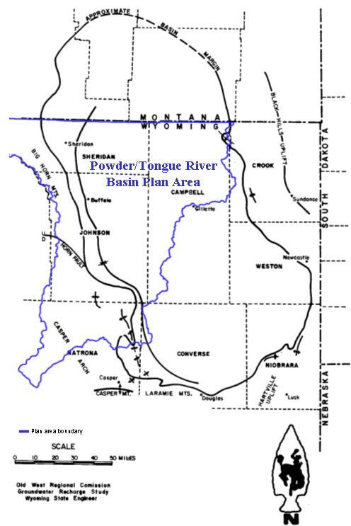
Figure 1.0 Location and Geologic Structure Map, Powder/Tongue River Basin Plan Area, Wyoming
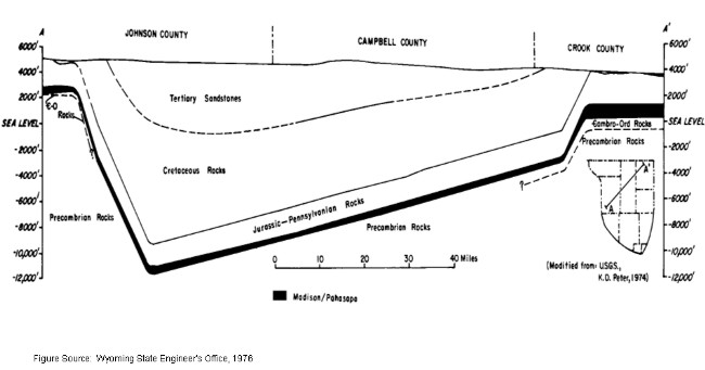
Figure 2.0 Generalized Geologic Section in Northeastern Wyoming
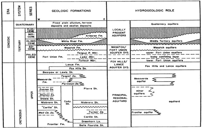
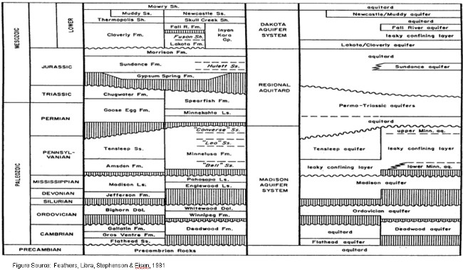
Figure 3.0 Diagrammatic Hydrostratigraphy of the Powder River Structural Basin within the
Powder/Tongue River Basin Plan Area.
LIST OF TABLES
Table 1.0 Lithologic and Hydrologic Characteristics of Bedrock Units Exposed on the West Flank of the Powder River Structural Basin, Wyoming (compiled from numerous sources).
| Erathem | System | Geological Unit | Thicknessa (ft) |
Lithologic Character | Hydrologic Characterb,c |
| MESOZOIC | Cretaceous | Lewis Shale (Bearpaw Shale) |
200-900+/- 470 |
Grey marine shale with sandy shale and thin lenses of fine-grained sandstone (Teckla). | Regional aquitard but some low-yield wells near outcrop |
| Mesaverde Fm. | 355 900+/- |
Fine- to medium-grained sandstone with interbedded grey marine shale. Upper part is Teapot Ss. (50 ft.) in south, Lower part is Parkman Ss. (500+/-) | Minor aquifer (entire basin flank). Flowing yields up to 4 gpm; pumped yields up to 120 gpm reported in Natrona Co.; specific capacity. 0.1-0.2 gpm/ft. Oil field data: porosity, 15-21%; permeability, 5 gpd/ft2; transmissivity, 120 gpd/ft. | ||
| Cody Shale (Steele Shale is upper part) |
3700+/- 3000-5000 |
Dark grey shale, limey near base with some bentonitic beds and interbedded, lenticular fine-grained often shaley sandstones (Shannon, 200 ft; Sussex, 200-500 ft). | Aquitard but sandstone lenses have low-yield flowing and pumped wells near outcrop. Oil field data: porosity, 12-25%, permeability, 8 gpd/ft2; transmissivity, 85 gpd/ft. | ||
| Frontier Fm. | 515+/- 900 |
Dark grey to black marine shale with interbedded thin to massive bedded fine- to medium-grained sandstones (Wall Creek sands). | Minor Aquifer (southwest basin). Flowing yields 1-10gpm (Natrona Co.); specific capacity, 0.02 gpm/ft (Sheridan Co.). Oil field data: porosity, 12-26%, permeability, 0.09-9 gpd/ft2; transmissivity, 150 gpd/ft. | ||
| Morwy Shale | 525+/- 200-300 |
Grey weathering siliceous shale with bentonitic beds, non-siliceous black shale at base. | In Natrona Co., flowing yields up to 2 gpm; pumped yields up to 10 gpm. | ||
| Muddy Ss. (Newcastle Ss.) |
0-40+/- 6+/- |
Light grey, fine-grained, lenticular sandstone and siltstone often termed a member of Thermopolis shale. | Minor unit of Dakota aquifer system Oil field data: porosity, 5-20%, permeability, <7 gpd/ft2; transmissivity, <150 gpd/ft. | ||
| Thermopolis Sh. (Skull Creek Sh.) |
175+/- 200 |
Black marine shale with some siltstone partings in north. | Aquiard; no published record of wells. | ||
| Cloverly Fm. | 150 140 |
Interbedded dark shale and brown siltstone with 15-45 feet of basal fine- to coarse-grained well sorted sandstone | Lower part is unit of Dakota aquifer system. Flowing yields of 1-40 gpm. up to 250 gpm reported for pumped wells; specific capacity, 0.2 gpm/ft. Oil field data: porosity, 15-18%, permeability, 0.4-4 gpd/ft2; transmissivity, 7-230 gpd/ft. | ||
| - Unconformity - | |||||
| Jurassic | Morrison Fm. | 185 130-220 |
Varigated shale and claystone with some lenticular fine-grained sandstones. | No published record of wells. | |
| Sundance Fm. | 280 300 |
Shale, greenish grey, sometimes calcareous, sandier at top and base. | A few water wells, some flowing up to 2 gpm. Oil field data: porosity, 14-20%, permeability, 3 gpd/ft2; transmissivity, 8-132 gpd/ft. | ||
| - Unconformity - | |||||
| Gypsum Spring Fm. | 120-185 absent |
Red shale and claystone with thin bedded limestone and gypsum. | Not generally considered an aquifer and no published record of wells. | ||
| - Unconformity - | |||||
| Triassic | Chugwater Fm. | 750-800 700-800 |
Red siltstone, claystone and fine-grained sandstone with thin limestone. | Aquitard but a few wells, some flowing several gpm. | |
| MESOZOIC and PALEOZOIC |
Triassic and Permian |
Goose Egg Fm. | 180-250 380 |
Interbedded red shale and siltstone with thin limestone and gypsum beds. | Aquitard but a few wells near outcrop |
| - Unconformity - | |||||
| PALEOZOIC | Permian and Pennsylvanian |
Tensleep Ss. |
50-250 <500 |
Fine- to medium-grained, massive, crossbedded sandstone with occasional thin dolomite beds. | Unit of Madison aquifer system. Flowing yields up to 400 gpm; specific capacity, 1 gpm/ft. Oil field data: porosity, 0-24%, permeability, 0-21 gpd/ft2; transmissivity, 0-1900 gpd/ft. |
| Pennsylvanian | Amsden Fm. | 150-300 0-200 |
Red and purple shale with some sandstone, cherty dolomite and limestone. | Aquitard unless fractured | |
| - Unconformity - | |||||
| Mississippian | Madison Ls. | 1100+/- 200-400 |
Limestone, dolomitic limestone, and dolomite sandy at base. | Principle unit of Madison aquifer system. Flowing yields up to 4000 gpm but highly variable; specific capacity, <1 to 50 but is flow-dependent; transmissivity, 500-90,000 gpd/ft or higher and highly variable. | |
| - Unconformity - | |||||
| Ordovician | Bighorn Dolomite | 400-500 absent |
Massive dolomite, becomming thin-bedded at top and sandy at base. | Unit of Madison aquifer system. Local outcrop wells only. | |
| - Unconformity - | |||||
| Cambrian | Gallatin and Gros Ventre Fms., undivided |
645+/- 0-500 |
Upper limestone, limestone conglomerate, interbedded with middle micaceous shale and a basal, brown,medium- to coarse-grained sandstone. | Aquitard; no published reports of wells. | Flathead Ss. | 345+/- 90 |
Tan to reddish sandstone, locally conglomoratic, interbedded with green shale and siltstone. | Minor unit of Madison aquifer system. Not exploited due to deep burial but a few wells yield water near outcrop. |
| - Unconformity - | |||||
| PRECAMBRIAN | - | - | - | Complex of igneous and metamorphic rocks. |
Locally yields small amount of water to shallow, outcrop wells |
aFirst thickness range refers to northwestern basin, second refers to southwestern basin.
bOilfield data are variously derived resulting in internal inconsistencies in this compilation. Permeabilities are measured on cores or derived from other data and transmissivities are from drill stem tests or calculated from permeability. Test data are usually for limited horizons of high anticipatied yields and are not therefore representative of the formation as a whole.
cReported yields may reflect development needs rather than aquifer capability; higher yields can sometimes be expected, with corresponding drawdown increases. Reported water well transmissivities or permabilities may be for wells completed in two aquifers, or screened in only part of a single aquifer.
Table 2.0 Lithologic and Hydrologic Characteristics of .Shallow. Geologic Units (Including Quaternary,
Tertiary and Latest Cretaceous Deposits) of the Central Powder River Structural Basin, Wyoming
| Erathem | System | Series | Geological Unit | Thickness (ft) |
Lithologic Character | Hydrologic Charactera |
| CENOZOIC | Quaternary | Holocene and Pleistocene |
Alluvium and Terrace deposits | 0-100+ | Silt, sand and gravel; unconsolidated and interbedded; present along most streams. | Quaternary alluvial aquifers. Yield of 1000 gpm possible, often through induced recharge. Terrace topographically high and often drained. Specific capacity, 0.3-18 gpm/ft; porosity, 28-45%; permeability, 0.1-1100 gpd/ft2; transmissivity, 15-64000 gpd/ft; specific yield, 2-39%. Coarser deposits have better aquifer properties. |
| - Unconformity - | ||||||
| Tertiary | Miocene | Arikaree Fm. | 0-500 (southeast only) |
Tuffaceous sandstone, fine-grained, with silty zones, coarse sand lenses and concretionary zones. | Middle Teritiary aquifers. Yields up to 1000 gpm; specific capacity up to 232 gpm/ft; porosity, 5-24%; permeability, <1-300 gpd/ft2; transmissivity, up to 77,000 gpd/ft. | |
| - Unconformity - | ||||||
| Oligocene | White River Gp. | 0-1500 (isolated outliers except in SE) |
Tuffaceous siltstone in upper part, underlain by claystone, both locally contain fine- to coarse-grained sandstone and conglomorate channel deposits. | Middle Teritiary aquifer. Not extensively developed because overlain by Arikee Fm. in most places. Yields generally low and unpredictable. Specific capacity, <0.5 gpm/ft; permeability, 0.0002-0.03 gpd/ft2, increases with fracturing. | ||
| - Unconformity - | ||||||
| Eocene | Wasatch Fm. | Up to 1600 | Fine- to coarse-grained lenticular, sandstones interbedded with shale and coal, coarser in south and southwest, conglomeratic in the west. | Part of Wasatch/Fort Union aquifer system. Yields generally <15 pgm, locally flowing wells exist. Specific capacity, 0.10-2 gpm/ft; porosity >28-30%; permeability, 0.01-65 gpd/ft2; transmissivity, average 500 gpd/ft. range 1-4000 gpd/ft. | ||
| - Unconformity - | ||||||
| Paleocene | Fort Union Fm. | 1100 - 2500+ | Sandstone, fine- to coarse-grained, lenticular, interbedded with siltstone, coal and shale. Middle part may be shalier in north, upper part siltier in south. "Clinker" associated with coal outcrops. | Part of Wasatch/Fort Union aquifer system. Flowing yields of 1-60 gpm were confined. Pumped yields up to 250 pgm with several hundred feet of drawdown. Specific capacity, 0.1-2 gpm/ft; permeability, 0.01-100 gpd/ft2; transmissivity, 1-5000 gpd/ft. Coal and clinker generally better aquifer properties than sandstones. Locally clinker transmissivity up to 3,000,000 gpd/ft; specific capacity over 2000 gpm/ft. Anisotropy and leaky confining layers are common | ||
| MESOZOIC | Cretaceous | Upper Cretaceous |
Lance Fm. | 500-1000 (N) 1600-3000 (S) |
Sandstone, fine- to medium-grained, lenticular, interbedded with sandy silstone and claystone. | Unit of Fox Hills/Lance aquifer system. Yields up to 350 gpm but with large drawdowns and long perforated intervals. Locally flowing wells exist. Specific capacity, 0.05-2 gpm/ft; permeability, 6-35 gpd/ft2; transmissivity, 170-2100 gpd/ft. | Fox Hills Ss. | 150-200 (N) 400-700 (S) |
Sandstone, fine- to medium-grained, interbedded with shale and silstone. | Unit of Fox Hills/Lance aquifer system. Yields up to 350 gpm but with large drawdowns and long perforated intervals. Locally flowing wells exist. Specific capacity, 0.05-2 gpm/ft; permeability, 34 gpd/ft2; transmissivity, 76-1600 gpd/ft for wells also completed in Lance. |
Table 3.0 Publications Containing Ground Water Quality Data,
Reviewed for the Powder/Tongue Basin Plan
| Title | Authors | Publishing Agency/ Date of Publication |
| Occurrence and Characteristics of Ground Water in the Powder River Basin, Wyoming | K. R. Feathers, R. Libra, T. R. Stephenson and C. Eisen |
Wyoming Water Resources Research Institute (1981) |
| Ground-Water Resources of Sheridan County, Wyoming (USGS Water-Supply Paper 1807) | M. E. Lowry and T. R. Cummings |
U.S. Geological Survey (1966) |
| Ground-Water Resources and Geology of Northern and Central Johnson County, Wyoming (USGS Water-Supply Paper 1806) | H. A. Whitcomb, T. R. Cummings and R. A. McCullough |
U.S. Geological Survey (1966) |
| Ground-Water Resources of Natrona County, Wyoming (USGS Water-Supply Paper 1897) | M. A. Crist and M. E. Lowry |
U.S. Geological Survey (1972) |
| Ground-Water-Quality Data from the Powder River Structural Basin and Adjacent Areas, Northeastern Wyoming (USGS Open-File Report 83-939) | L. R. Larson and R. L. Daddow |
U.S. Geological Survey (1984) |
| Ground Water Quality in Wyoming (USGS Water-Resources Investigations Report 84-4034) | L. R. Larson | U.S. Geological Survey (1984) |
| Water Co-produced with Coalbed Methane in the Powder River Basin, Wyoming: Preliminary Compositional Data (USGS Open-File Report 00-372) | C. A. Rice, M. S. Ellis and J. H. Bulloch, Jr. |
U.S. Geological Survey (2000) |
Table 4.0 Summary of Ground Water Availability/Development Potential of Major Aquifer Systems, Central and Western Flanks of the
Powder River Structural Basin, Powder/Tongue River Basin Plan Area, Wyoming
(Feathers, Libra, Stephenson and Eisen, 1981)
| Major Aquifer System | Geologic Unit | Thickness (Feet) |
Lithologic Character | Hydrological CharacterA,B | General Water Quality | Availability / Development PotentialC | Remarks |
| Quaternary Alluvial Aquifer System | Alluvium and Terrace Deposits | 0-100+ | Silt, sand and gravel; unconsolidated and interbedded; present along most streams. | Yield of 50 to 300 gpm may be possible, often through induced recharge. Terraces topographically high and often drained. Specific capacity, 0.3-7 gpm/ft; permeability, 380 and 1100 gpd/ft2 and transmissivity, 9700 and 20300 gpd/ft from two tests in Sheridan County (Lowry and Cummings, 1966). Coarser deposits have better aquifer properties. | TDS content generally range from about 100 to >4000 mg/l. Chemical characteristics of water differ geographically. Chemical type and mineralization of the water can be expected to vary depending on underlying rock types and the nature and degree of interconnection with surface water. Alluvial deposits in the western part of the planning area generally contain water of better quality than alluvial deposits in the eastern part. Suitability for municipal / public, domestic, irrigation and stock is variable and dependent on location and above factors. | Historical source for municipal / public, domestic and stock use. Production has ranged up to 250 gpm with induced infiltration of surface water. Ground water development potential generally better in coarse-grained deposits and poorer in fine-grained materials. Moderate to high yields might be possible to optimally located and properly designed wells if induced infiltration from surface water can be tolerated in the upper reaches of Powder River, Piney, Clear and Crazy Woman Creeks. Moderate supplies may be able to be developed in thicker deposits of coarse material in the alluvuim of Prairie Dog Creek as well as the alluvium of the Tongue River and Dutch Creek. (Lowry and Cummings, 1966), (Whitcomb, Cummings and McCullough, 1966) | Quaternary alluvial aquifers generally in hydraulic connection with all bedrock aquifers in outcrop areas and also with surface waters. Alluvial aquifers in larger valleys provide hydraulic interconnection between otherwise hydraulically isolated bedrock aquifers (Whitcomb, 1965). Alluvial aquifers also serve as interchange point and storage for ground water in the hydrologic cycle (Davis and Rechard, 1977), (Davis, 1976). Induced recharge from surface waters is probable in areas of extensive development. |
| Fort Union / Wasatch Aquifer System | Wasatch Formation | 500 to 2000+/- | Fine- to coarse-grained lenticular sandstones interbedded with shale and coal. Yields water from, lenticular sandstone and to a lesser extent from jointed coal and clinker beds (Hodson, Pearl and Druse, 1977). Divided into two conglomeratic members (Kingsbury and Moncrief Members) near the Bighorn Mountains (Lowry and Cummings, 1966). | Yields generally <15 gpm. Specific capacity of Wasatch wells and those completed in the coarse grained facies of the Wasatch Formation in Sheridan County averaged 0.33 and 1.0 gpm/ft respectivley; permeability, 6.5 gpd/ft2 (one test - coal, Sheridan County); transmissivity, 520 gpd/ft (one test - coal, Sheridan County) and 2200 gpd/ft (one test - sandstone, Sheridan County). (Lowry and Cummings, 1966) | TDS content of waters is variable and ranges from 141 to 6620 mg/l (Larson, 1984). Sulfate and Iron content range from 0.6 - 4080 mg/l and 0 - 25 mg/l respectively and water varies from soft to very hard. Dominant cations generally are Sodium, Calcium and Magnesium, Sodium and Calcium, or Sodium and Magnesium. (Lowry and Cummings, 1966), (Whitcomb, Lowry and McCullough) | Important local source for domestic and stock water supply. Yields from fine grained facies generally small and barely adequate for stock and domestic use and generally can be expected to be < 15 gpm. Wells completed in the Kingsbury Conglomerate and Moncrief Members may have potential for higher production. Water quality generally suitable for domestic supplies although undesireable constituents may make other water sources more attractive if available. Water quality suitability for stock ranges from poor to good. Generally unsuitable for irrigation due to high salinity and sodium content. | Kingsbury Conglomerate and Moncrief Members located at the base of the mountains in Sheridan Counties. |
| Fort Union Formation | 1200-3900 | Sandstone, fine- to medium-grained, lenticular, interbedded with siltstone, coal and shale. "Clinker" associated with coal outcrops. | Flowing yields of 1-60 gpm reported where confined. Pumped yields up to 250 gpm with several hundred feet of drawdown (eastern Campbell County, east of planning area). Specific capacity for 85 wells in Sheridan County averaged 0.42 gpm/ft; permeability (2.5 and 7.9 gpd/ft2), transmissivity (10 and 95 gpd/ft), and Storage coefficient (9.0 X 10⁻⁵ and 3.5 X 10⁻⁴) for tests performed on two wells in Sheridan County (Lowry and Cummings, 1966). Coal and clinker generally better aquifer properties than sandstones. Locally clinker transmissivity up to 3,000,000 gpd/ft; Anisotropy and leaky confining layers are common. | TDS content of waters is variable and ranges from 484 - 4630 mg/l (Larson, 1984). Sulfate and Iron content range from 0.3 - 1870 mg/l and 0.06 - 19 mg/l respectively. Water varies from soft to very hard and is generally a Sodium Bicarbonate type. (Lowry and Cummings, 1966), (Whitcomb, Cummings and McCullough, 1966) Water co-produced with coal bed methane is predominantly Sodium Bicarbonate type with TDS content and SAR (15 samples), of 540 - 2010 mg/l (mean of 1309 mg/l) and 7.7 - 32 (mean of 19.82) respectively in planning area. (Rice, Ellis & Bullock, 2000). BLM Wyodak EIS assumed average TDS concentration of 764 mg/l (USDI,BLM, 1999). | Important, extensively used relatively shallow (< 1000 feet depth) local source for domestic and stock supply. Low yields, generally less than 25 gpm can be expected. Four of the 12 municipal / public supply wells in service for the City of Gillette (east of planning area) as of 1994 had been tested at pumping rates ranging from 50 to 130 gpm (Wester -Wetstein and Associates, Inc., 1994). | Total of 6820 Coal Bed Methane wells permitted with WSEO in planning area as of 12/31/00. Maximum, minimum and mean depths and range of actual yields listed on permits were 92 -4100 (mean 637) feet below ground surface (bgs), and 1 - 60 (mean 49) gpm respectively. Range of depths to main water bearing zone listed on WSEO Permits were 58 - 3816 (mean 580) feet bgs. BLM Exxon Pistol Point EA assumed average water production for each CBM well to average between 30 and 45 gpm (USDI,BLM, 1992). BLM Lower Prairie Dog Creek EA assumed average water production for each CBM well to be 15 gpm (USDI,BLM, 1999). BLM Wyodak EIS assumed average expected water production to be 12 gpm over the estimated 12 year life of each CBM well (USDI,BLM, 1999). BLM Wyodak Drainage EA assumed average water production for each CBM well to be 11.1 gpm (USDI,BLM, 2000). | Fox Hills/Lance Aquifer System | Lance Formation | 600-1900 (North) 1950-3000 (South) |
Sandstone, fine- to medium-grained, lenticular, interbedded with sandy siltstone, claystone and shale. | Generally yields less than 15 gpm with specific capacities, 0.03-.16 gpm/ft in planning area. Limited development due to uneconomical drilling depths. In eastern area of Powder River Structural Basin (PRSB), yields up to 350 gpm but with large drawdowns and long well completion intervals; permeability 34 gpd/ft2; transmissivity, 76-2100 gpd/ft for wells also completed in Fox Hills Sandstone. | TDS content in waters generally range from <500 - 3060 mg/l. Composition variable, mainly Sodium Sulfate or Calcium Sulfate. Variable iron ( 0 - 6.03 mg/l) and Sulfate (<100 - 1780 mg/l) content, SAR 1.9 - 39. Generally undesireable for domestic water source due to possible high Iron, Manganese and Sulfate content. Generally fair to poor for stock use. Unsuitable for irrigation due to high salinity and / or high SAR. | Historical source for domestic and stock supply. Generally yields less than 15 gpm in planning area. Development limited due to uneconomical drilling depths. Water quality generally suitable for domestic supplies although undesireable constituents may make other water sources more attractive if available. Water quality suitability for stock ranges from poor to good. Generally unsuitable for irrigation due to high salinity and / or Sodium content. | Fox Hills Sandstone | 0-700 | Sandstone, fine-to medium-grained, interbedded with shale and siltstone. | Generally yields less than 15 gpm with specific capacities, 0.03-.37 gpm/ft in planning area. Transmissivity, 76-1600 gpd/ft for wells also completed in Lance Formation. Limited development due to uneconomical drilling depths. | Similar to Lance Formation. Water suitable for domestic use usually present only near outcrop. Water suitable for stock use generally found at depths of up to 1000 feet, away from outrop. The quality of water may be unsatisfactory for domestic and stock use where the the aquifer is is deeper than 1000 feet. (Crest and Lowry, 1972) | Historical source for municipal / public, domestic and stock supply. Generally yields less than 15 gpm in planning area. No more than 50 gpm can be expected from wells completed in wells in the planning area (Natrona County). Well for Town of Edgerton produced 25 gpm with a specific capacity of 0.037 gpm/ft. (Crist and Lowry, 1972) Development limited due to uneconomical drilling depths. Tested yields of Gillette municipal / public supply wells (east of planning area) have ranged from 85 to 705 gpm (Wester-Wetstein and Associates, Inc., 1994). | High Fluoride content may be of concern in eastern part of planning area. Has been used as municipal / public water supply source for Town of Edgerton. Has been used for oil well water flooding operations in eastern PRSB. |
| Dakota Aquifer System | Muddy Sandstone (NewCastle Sandstone) |
0-40+/- | Light gray, fine-grained, lenticular sandstone and siltstone often termed a member of Thermopolis shale. | Minor unit of Dakota Aquifer System. Oil field data (PRSB): porosity, 5-20%; permeability, <7 gpd/ft2 ; transmissivity, <150 gpd/ft. | No data in planning area. | No data in planning area. Ground water possibilities in planning area generally not known. Probably capable of yielding small quantities of no more than 10 gpm water to wells. Deep drilling depths would probably preclude consideration other than at outcrops. Dakota Aquifer System historical source for domestic and stock use in eastern PRSB. | |
| Cloverly Formation | 140-150 | Interbedded dark shale and brown siltstone with 15-45 feet of basal, fine - to coarse-grained well sorted sandstone. | Flowing yields of 1-40 gpm, up to 250 gpm reported for pumped wells (south of planning area); specific capacity, 0.12-.2 gpm/ft. Oil field data: porosity, 15-18%; permeability, 0.4-4 gpd/ft2; transmissivity, 7-230 gpd/ft. | Water from Cloverly and Morrison Formations in Natrona County predominantly Sodium Bicarbonate type. Other types include Calcium Bicarbonate, Calcium Sulfate, Sodium Sulfate, and Calcium Sulfate. TDS content range between 300 and 3000 mg/l. | Generally deeply buried in planning area except at outcrops. Yields small supplies to springs at outcrops. Well yields of 5 to 20 gpm may be expected. Yields of greater than 100 gpm may be possible from complete section of rocks. | ||
| Madison Aquifer System | Tensleep Sandstone | 50-250 (Northwestern Basin) <500 (Southwestern Basin) |
Fine- to medium-grained, massive, crossbedded sandstone with occasional thin dolomite beds. | Unit of Madison Aquifer System. Flowing yields up to 400 gpm; Specific capacity, 1 gpm/ft. Oil field data: porosity, 0-24%; permeability, 0-21 gpd/ft2; transmissivity, 0-1900 gpd/ft. | Water type is variable ( Magnesium Carbonate, Calcium Magnesium Sulfate, Sodium Sulfate,Calcium Sodium Sulfate, Calcium Sulfate) and concentration of TDS varies directly to distance from the outcrop and generally ranges from<300 -3240 mg/l. Generally very hard but suitable for domestic, stock and irrigation use at or near outcrop. (Crist and Lowry, 1972), (Whitcomb, Cummings and McCullough, 1966) TDS content 204 - 2930 mg/l in six samples in Natrona County (Larson, 1984). | Sandstone generally well cemented, but primary permeability is sufficient at most locations to permit yields of 50 gpm to wells. There is potential for higher yields where secondary permeability is high. Yield of 600 gpm reported for an irrigation well at the foot of the Bighorn Mountains in Johnson County . Development may be limited economically due to deep drilling depths in Johnson County in outcrop area or in narrow belt generally less than about one mile paralleling the east margin of the outcrop. (Whitcomb, Lowry, and (McCullough 1966), (Crist and Lowry, 1972) | |
| Amsden Formation | 150-300 (Northwestern Basin) 0-200 (Southwestern Basin) |
Red and purple shale with some sandstone, cherty dolomite and limestone. | Aquitard unless fractured. | Generally deeply buried in planning area except at outcrops. Ground water possibility generally not known. | |||
| Madison Limestone | 1100+/- (Northwestern Basin) 200-400 (Southwestern Basin) |
Limestone, dolomitic limestone and dolomite, sandy at base. | Principal unit of Madison Aquifer System. Flowing yields over 4000 gpm but highly variable; specific capacity. <1 to 50 but is flow-dependent; transmissivity, 500-90,000 gpd/ft or higher and highly variable. | Waters at Outcrop (TDS < 600mg/l, predominantly Calcium Magnesium Bicarbonate type water). TDS increase basinward to > 3,000 mg/l, Sodium Sufate Chloride predominating. Fluoride enrichment characteristic of Madison System waters throughout the PRSB basin. Concentrations of radionuclides could be of concern in some areas. | Probably most important high yield aquifer in Wyoming. Historical source for municipal / public water supply, industrial, irrigation and stock use in PRSB. Several fish hatcheries use Pahasapa / Madison aquifer as water source in northeastern part of PRSB. Yields variable geographically and dependent on secondary permeability. Drilling depths may inhibit development. | Total estimated recharge to the Madison Limestone in the PRSB in 1973 was about 75,000 acre feet/year. (WSEO, 1976) | |
| Bighorn Dolomite | 400-500 (Northwestern Basin) absent (Southwestern Basin) |
Massive dolomite, becoming thin-bedded at top and sandy at base. | Generally deeply buried except in outcrop areas. Ground water possibilities generally not known. | Ground water possibilities generally not known. Probably would yield water to wells depending on secondary permeability. | Flathead Sandstone | 345+/- (Northwestern Basin) 90 (Southwestern Basin) |
Tan to reddish sandstone, locally conglomeratic, interbedded with green shale and siltstone. | Minor unit of Madison Aquifer System. Not exploited due to deep burial but a few wells yield water near outcrops. | Ground water possibilities generally not known. Probably would yield water to wells depending on secondary permeability. Generally deeply buried except in outcrop areas. Yields small quantities of water to springs from sandstone and conglomerate in the Bighorn Mountains. (McCullough 1966), (Crist and Lowry, 1972) |
AReported yields may reflect development needs rather than aquifer capability; higher yields can sometimes be expected, with corresponding drawdown increases. Reported water well transmissivities or permeabilities may be for wells completed in two aquifers or screened in only part of a single aquifer. Reported ranges include varying amounts of data. (Feathers, Libra, Stephenson and Eisen, 1981)
BOilfield (and USGS test) data are variously derived resulting in internal inconsistencies in this compilation. Permeabilities are measured on cores or derived from other data and transmissivities are from drill stem tests or calculated from permeability. Test data are usually for limited horizons of high anticipated yields and are not therefore representative of the formation as a whole. (Feathers, Libra, Stephenson and Eisen, 1981)
CActual development potential will require site specific office and field investigations to define aquifer capability and constraints unique to each project and site.
LIST OF APPENDICES
| Appendix A |
Bibliography of Selected Groundwater Studies and Planning Documents, Powder/Tongue River Basin Plan Area |
| Appendix B | Geology and Ground Water Use Plates, Powder/Tongue River Basin Plan Area |
Plate B.1 Surficial Geology Plate B.2 Bedrock Geology
Plate B.2.1 Bedrock Geology, Detailed LegendPlate B.3 Surficial Geology With Permitted Active Agricultural, Municipal,
Industrial and Miscellaneous Wells with Production Rates Greater than
49 gpmPlate B.4 Bedrock Geology with Permitted Active Agricultural, Municipal,
Industrial and Miscellaneous Wells with Production Rates Greater than
49 gpmPlate B.5 Surficial Geology with Active Permitted Domestic Wells Plate B.6 Bedrock Geology with Active Permitted Domestic Wells Plate B.7 Surficial Geology with Active Permitted Stock Wells Plate B.8 Bedrock Geology with Active Permitted Stock Wells Plate B.9 Surficial Geology with Permitted Coalbed Methane Wells Plate B.10 Bedrock Geology with Permitted Coalbed Methane Wells
| Appendix C | Data Summary of Hydrogeology, Hydrologic Properties and Well Specific Capacities of Selected Aquifer Systems, Powder/Tongue River Basin Plan Area |
| Appendix C.1 | Madison Aquifer System |
Figure C.1.1 Depth to the Madison Limestone and Equivalent Rocks in the Powder River Structural
Basin and Adjacent AreasFigure C.1.2 Thickness of Madison Limestone in Wyoming and its Regional Limits Figure C.1.3 Potentiometric Surface in the Madison Aquifer Table C.1.1 Reported Transmissivities and Storage Coefficients for the Madison Aquifer in the
Powder River Structural Basin, WyomingTable C.1.2 Calculated Specific Capacities (yield per unit drawdown) of Madison Aquifer Wells,
Powder River Structural Basin, Powder/Tongue River Basin Plan Area, WyomingTable C.1.3 Hydrologic Properties of Permo-Pennsylvanian Rocks of the Madison Aquifer System,
Powder River Structural Basin, Powder/Tongue River Basin Plan Area, Wyoming
| Appendix C.2 | Dakota Aquifer System |
Figure C.2.1 Potentiometric Surface in the Dakota Aquifer System Table C.2.1 Hydrologic Properties of Lower Cretaceous Rocks of the Dakota Aquifer System, Powder
River Structural Basin, Powder/Tongue River Basin Plan Area, WyomingTable C.2.2 Reported Specific Capacities (yield per unit drawdown) of Wells in the Dakota Aquifer
System, Powder River Structural Basin, Powder/Tongue River Basin Plan Area, Wyoming
| Appendix C.3 | Fox Hills Lance Aquifer System |
Figure C.3.1 Contours on Water Levels in Wells Finished in the Fox Hills Sandstone, Lance Formation
and Lower Part of the Fort Union Formation in the Gillette Area, WyomingTable C.3.1 Reported Transmissivities and Permeabilities for Wells in the Fox Hills/Lance Aquifer System,
Powder River Structural Basin, Powder/Tongue River Basin Plan Area, WyomingTable C.3.2 Reported Specific Capacities (yield per unit of drawdown) of Wells in the Fox Hills/Lance Aquifer
System, Powder River Structural Basin, Powder/Tongue River Basin Plan Area, Wyoming
| Appendix C.4 | Fort Union/Wasatch Aquifer System |
Figure C.4.1 Transmissivities of the Wasatch/Fort Union Aquifer System, Powder River Structural Basin,
Powder/Tongue River Basin Plan Area, Wyoming
| Appendix D | Aquifer Sensitivity to Contamination
and Ground Water Vulnerability to Pesticides, Powder/Tongue Basin Plan Area |
Plate D.1 Aquifer Sensitivity to Contamination Plate D.2 Aquifer Vulnerability to Pesticides