Wyoming State Water Plan
Wyoming State Water Plan
Wyoming Water Development Office
6920 Yellowtail Rd
Cheyenne, WY 82002
Phone: 307-777-7626

Wyoming Water Development Office
6920 Yellowtail Rd
Cheyenne, WY 82002
Phone: 307-777-7626


| SUBJECT: |
Appendix A Irrigation Diversion Operation and Description |
| PREPARED BY: | HKM Engineering Inc. |
| DATE: | March 2002 |
INTRODUCTION
In accordance with the scope of services, an inventory of the diversions located within the Powder River and Tongue River Basins were completed. This inventory is intended to be used for future planning and to provide information for water availability modeling of the basins.
DIVERSION SELECTION
The initial selection of diversions to be inventoried was based on a review of the State Engineer's Office hydrographers' annual reports. Those ditches with a recorded diversion of 10 cfs or greater were selected. The list of these diversions was submitted to the State Engineer's Office Division Two superintendent and hydrographers/commissioners for review and refinement. The commissioners eliminated several diversions and added others. Finally, to ensure that the data summarized here fully represented the drainages in the Powder/Tongue River Basin, commissioners were asked to add the ditches they considered key to the water use in the drainages. The resulting list of diversions provides a broad coverage of data and the significant data available on diversion operations in the Powder/Tongue River Basin.
METHODOLOGY
Data Gathering for Operation Memoranda
Each of the major ditches listed were visited in the field. During these field inspections, points of diversion and flow measurement facilities were photographed and located with a Garmin GPS II Plus handheld GPS unit. The removal of the selective availability dithering in May, 2000 and its capacity for averaging readings over time gave this handheld GPS receiver the ability to receive locations to within +/- 12 feet in many cases. These measurements are provided for general location purposes only; no guarantee can be made of their accuracy.
Travel with a hydrographer/commissioner was required in most cases to access Powder/Tongue River Basin headgates and flow measurement devices. In parts of the northern Powder/Tongue River Basin, area landowners were relied upon to obtain the necessary data. Follow-up interviews with landowners and all commissioners provided the supplemental information used in the following technical reports detailing each diversion.
Compilation of Diversion Records
In accordance with the scope of services, diversion records have been compiled for the selected ditches as defined in the preceding section. The diversion records when associated with the acreage served will provide a basis for determining the actual water use for irrigation in the study area. Actual water use is commonly significantly less than theoretical water use based on crop consumptive irrigation requirements, waste/seepage, deep percolation, and conveyance losses. This is expected to be especially true within this study area where forage crops rather than cash crops constitute the predominant demand for irrigation water. Information on actual monthly water use for irrigation is important to the development of water availability models that realistically simulate existing conditions in the area.
Records of ditch diversions are available in several forms and from several sources as summarized below. The records for the sites maintained by the Wyoming State Engineer's Office (SEO) are contained in the Hydrographers' Annual Reports beginning in 1980.
The SEO has not developed a numbering system for the measurement sites. This presented a significant challenge in completing this task. Records are identified in the Hydrographers' Annual Reports only by the name of the ditch. Unfortunately, these names sometimes change over time. It therefore becomes very difficult to determine if the different names relate to a different site or a change in the name of a given site. To solve this problem, sites with similar names were summarized on tracking forms for all 20 years of record by listing the site name, source, district, and size of the Parshall measuring flume for each year. This information generally provided the clues necessary to make the determination. HKM also maintained close contact with Mike Whitaker, the Water Division II superintendent, and hydrographer / commissioners Carmine LoGuidice and Bill Knapp when questions arose.
The total monthly diversion volumes as calculated by the SEO and USGS or available from the WRDS database (categories 1, 2 and 3 above) are recorded directly on the diversion data summary sheets as provided herein with each respective ditch. The methodology used in estimating missing daily diversion rates and total monthly diversion volumes at spot measurement sites (category 4 above) is discussed in the following section. The resulting monthly diversion volumes for these sites are also recorded on the diversion data summary sheets for each ditch.
Interviews with landowners, ditch maintenance personnel, and SEO staff provided return flow amounts and locations where available.
ESTIMATED DAILY DIVERSION RATES AND MONTHLY DIVERSION VOLUMES
The monthly diversion volumes listed on the diversion data summary sheets derived from spot measurements were calculated using the following technique:
Daily diversion data were compiled for each year and each pertinent ditch from the Hydrographers' Annual Reports.
Example: Moreton Ditch, 1992:
Lacking more information, it was assumed that the first date listed in the Annual Report is the date the ditch was turned on (i.e. there was no flow before that date), and the last date listed is the date that the ditch was turned off (i.e. there was no flow after that date). This assumption may result in an overestimate of the annual diversion volume in some cases but more typically would result in an underestimate where diversions at the beginning and end of the season are truncated from the record.
Date Flow (cfs) Date Flow (cfs) Date Flow (cfs) 5/4 5.36 8/1 1.80 8/28 1.26 5/11 1.26 8/5 13.05 8/31 1.26 5/15 10.16 8/7 12.38 9/2 1.26 5/18 0.00 (off) 8/10 7.53 9/8 7.53 5/26 18.60 8/15 11.25 9/9 7.15 5/29 16.00 8/17 2.15 9/11 7.53 6/1 0.00 (off) 8/19 2.39 9/14 7.53 6/3 3.77 8/21 2.78 9/16 1.80 6/5 1.27 8/24 2.39 9/21 2.15 6/12 0.00 (off) 8/26 2.92 9/23 2.15 7/31 1.26
The ditch flow for each missing day from the first to the last readings was found by linear interpolation. The interpolation process requires a judgement regarding the maximum number of days between recorded ditch flows for which interpolated estimates will be made. For periods with more than this number of days without flow measurements, the month or months containing those dates are left blank and are considered missing. If the maximum number is set too low, the resulting monthly volumes calculated will contain many missing values. If the maximum number is set too high, interpolation will be attempted over an unreasonably long time period. Based on a review of the available data, a maximum of 52 days was selected as the allowable maximum between measurement dates for interpolation to occur. A summary of the maximum number of missing days is provided along with the first and last dates of measured diversions for each ditch.
After the missing daily flows are estimated, the total monthly diversion volumes are calculated by summing the estimated and measured values for each respective month.
Example: Moreton Ditch, 1992:
Average, maximum, and minimum values for the period of record are calculated for each month of the irrigation season. The raw spot measurement data is extensive and is therefore not provided in this memorandum. This information is available in digital form and can be provided if necessary.
Date Flow (cfs) Date Flow (cfs) Date Flow (cfs) Date Flow (cfs) 5/1 5/10 1.85 5/19 2.33 5/26 18.60 5/2 5/11 1.26 5/20 4.65 5/27 17.73 5/3 5/12 3.45 5/21 6.98 5/28 16.87 5/4 5.36 5/13 5.71 5/22 9.30 5/29 16.00 5/5 4.77 5/14 7.94 5/23 11.63 5/30 10.67 5/6 4.19 5/15 10.16 5/24 13.95 5/31 5.33 5/7 3.60 5/16 6.77 5/25 16.28 5/8 3.02 5/17 3.39 Total for May (cfs) 214.23 5/9 2.43 5/18 0.00 May (AF) 424.92 Notes: Shaded figures are interpolated.
Total for May (cfs): This figure is the sum of the daily values.
May (AF): This figure is the total cubic feet per second (cfs) for May converted to acre-feet.
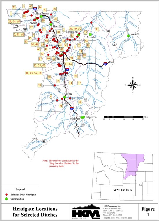
The ditches included in this memorandum are as follows (Figure 1):
| Memo Section |
Name of Site | Map Location Number |
Sub- Basin |
Source | Headgate Location | |
| Lat. | Long. | |||||
| Big Goose Creek |
Alliance Ditch Diversion | 2 | Tongue | Big Goose Cr. | N 44° 42' 9.9'' | W 107° 10' 48.3'' |
| Big Goose & Beaver No. 1 Ditch Diversion |
5 | Tongue | East Fork Big Goose Cr. |
N 44° 40' 12.0'' | W 107° 9' 19.1'' | |
| Big Goose & Beaver No. 2 Ditch Diversion |
5 | Tongue | Rapid Cr. | |||
| Grinnell Ditch Diversion on Big Goose Creek |
21 | Tongue | Big Goose Cr. | N 44° 49' 26.0'' | W 106° 57' 56.2'' | |
| Park Diversion Ditch | 45 | Tongue | East Fork Big Goose Cr. |
N 44° 34' 12.2'' | W 107° 12' 37.9'' | |
| PK (Patrick) Ditch Diversion | 51 | Tongue | Big Goose Cr. | N 44° 41' 47.6'' | W 107° 11' 24.8'' | |
| Sheridan City Intakes - Big Goose Canyon Diversion |
62 | Tongue | Big Goose Cr. | N 44° 41' 46.8'' | W 107° 11' 15.6'' | |
| Columbus Creek |
Five Mile Ditch Diversion | 16 | Tongue | Columbus Cr. | N 44° 55' 1.2'' | W 107° 22' 15.4'' |
| Little Goose Creek |
Burn Cleuch Ditch Diversion | 7 | Tongue | Little Goose Cr. | N 44° 43' 40.6'' | W 106° 56' 37.7'' |
| Colorado Colony Ditch Diversion | 33 | Tongue | Little Goose Cr. | N 44° 35' 46.4'' | W 107° 2' 20.8'' | |
| Gerdel Ditch Diversion | 20 | Tongue | Little Goose Cr. | N 44° 41' 30.0'' | W 106° 58' 59.0'' | |
| Last Chance Ditch Diversion | 10 | Tongue | Little Goose Cr. | N 44° 37' 41.8'' | W 107° 1' 44.7'' | |
| Peralta Ditch Diversion (& Mountain Supply Ditch Diversion) |
40, 48 | Tongue | Little Goose Cr. | N 44° 32' 47.7'' | W 107° 12' 37.4'' | |
| Tongue River |
High Line Ditch Diversion | 24 | Tongue | Tongue River | N 44° 50' 48.9'' | W 107° 18' 50.7'' |
| Interstate (Pennoyer) Ditch Diversion |
27 | Tongue | Tongue River | N 44° 56' 22.5'' | W 106° 57' 42.8'' | |
| OZ & K & Hanover Ditch Diversion |
44 | Tongue | Tongue River | N 44° 52' 49.2'' | W 107° 15' 29.9'' | |
| South Side Ditch Diversion | 64 | Tongue | Tongue River | N 44° 51' 24.7'' | W 107° 17' 48.3'' | |
| Tongue River No. 1 Ditch Diversion |
69 | Tongue | Tongue River | N 44° 50' 57.8'' | W 107° 18' 13.5'' | |
| York Ditch Diversion | 72 | Tongue | Tongue River | N 44° 52' 57.1'' | W 107° 13' 43.9'' | |
| Wolf Creek |
Garrard Ditch Diversion | 19 | Tongue | Wolf Cr. | N 44° 47' 22.9'' | W 107° 13' 6.2'' |
| Grinnell Ditch Diversion on Wolf Creek |
22 | Tongue | Wolf Cr. | N 44° 46' 24.4'' | W 107° 13' 55.5'' | |
| Clear Creek |
Big Bonanza Ditch Diversion | 3 | Powder | Clear Cr. | N 44° 29' 32.2'' | W 106° 33' 23.8'' |
| Clear Creek Land & Ditch Co. Ditch Diversion |
9 | Powder | Clear Cr. | N 44° 20' 2.1'' | W 106° 42' 53.2'' | |
| Crown Ditch Diversion | 12 | Powder | Clear Cr. | N 44° 19' 28.8'' | W 106° 44' 24.6'' | |
| Des Moines Ditch Diversion | 13 | Powder | Clear Cr. | N 44° 26' 52.4'' | W 106° 34' 34.3'' | |
| Four Lakes & French Creek Ditch Diversion |
17 | Powder | North Fork Clear Cr. |
N 44° 20' 15.9'' | W 106° 59' 56.6'' | |
| Frank G. Hopkins Ditch Diversion |
18 | Powder | Clear Cr. | N 44° 24' 50.3'' | W 106° 36' 2.2'' | |
| Hillyer & Onslow Ditch Diversion | 25 | Powder | Clear Cr. | N 44° 24' 6.3'' | W 106° 36' 52.2'' | |
| Johnson-Holt Ditch Diversion | 29 | Powder | Clear Cr. | N 44° 19' 46.3'' | W 106° 45' 28.9'' | |
| Kendrick Ditch Diversion | 30 | Powder | Clear Cr. | N 44° 49' 47.96" | W 106° 6' 49.67" | |
| Pratt & Ferris No. 2 Ditch Diversion |
54 | Powder | Clear Cr. | N 44° 37' 1.1'' | W 106° 24' 7.3'' | |
| Pratt & Ferris No. 3 Ditch Diversion |
55 | Powder | Clear Cr. | N 44° 39' 46.7'' | W 106° 21' 55.1'' | |
| Redman Ditch Diversion | 58 | Powder | Clear Cr. | N 44° 21' 47.2'' | W 106° 38' 59.1'' | |
| Roberts Ditch Diversion | 59 | Powder | Clear Cr. | N 44° 34' 40.9'' | W 106° 27' 31.7'' | |
| Six Mile Ditch Diversion | 63 | Powder| Clear Cr. |
N 44° 19' 44.9'' |
W 106° 45' 15.3'' | | |
| Crazy Woman Creek |
Cook Ditch Diversion | 11 | Powder | Crazy Woman Cr. | N 44° 11' 53.7" | W 106° 46' 29.1" |
| Devoe #1 Ditch Diversion | 14 | Powder | Crazy Woman Cr. | N 44° 3' 45.9'' | W 106° 40' 44.5'' | |
| John R. Smith Ditch Diversion | 28 | Powder| Crazy Woman Cr. |
N 44° 4' 12.0'' |
W 106° 36' 20.1'' | | |
| Kennedy Ditch Diversion | 31 | Powder | Crazy Woman Cr. | N 44° 10' 42.6'' | W 106° 44' 18.2'' | |
| Mitchell & Long Ditch Diversion | 37 | Powder | Crazy Woman Cr. | N 44° 4' 47.2'' | W 106° 38' 28.0'' | |
| Moreton Ditch Diversion | 38 | Powder | Crazy Woman Cr. | N 44° 3' 0.5'' | W 106° 44' 38.8'' | |
| North Fork Ditch Diversion | 43 | Powder | Crazy Woman Cr. | N 44° 10' 19.2" | W 106° 44' 48.0" | |
| PX Ditch Diversion | 57 | Powder | Crazy Woman Cr. | N 44° 10' 7.7'' | W 106° 44' 54.3'' | |
| Teddy Miller Ditch Diversion | 66 | Powder | Crazy Woman Cr. | N 44° 2' 54.6'' | W 106° 43' 7.8'' | |
| Thompson & Matthews Ditch Diversion |
67 | Powder | Crazy Woman Cr. | N 44° 11' 39.5'' | W 106° 47' 8.0'' | |
| Thompson Brothers Ditch Diversion |
68 | Powder | Crazy Woman Cr. | N 44° 10' 26.9'' | W 106° 45' 50.3'' | |
| French Creek |
Hopkins Ditch Diversion | 26 | Powder | French Cr. | N 44° 21' 59" | W 106° 47' 14" |
| Penrose Ditch Diversion (& Penrose Johnson Ditch Diversion) |
46, 47 | Powder | French Cr. | N 44° 21' 27.9'' | W 106° 50' 6.4'' | |
| Piney Creek |
Dunlap Ditch Diversion | 15 | Powder | Piney Cr. | N 44° 34' 36.5'' | W 106° 36' 23.0'' |
| Leiter Ditch Diversion | 34 | Powder | Piney Cr. | N 44° 32' 5.6'' | W 106° 49' 8.9'' | |
| Mead & Coffeen Ditch Diversion | 36 | Powder | North & South Piney Cr. |
N 44° 34' 47.1'' | W 106° 53' 36.1'' | |
| Piney & Cruse Ditch Diversion | 49 | Powder | North & South Piney Cr. |
N 44° 34' 43.0'' | W 106° 53' 11.8'' | |
| Piney Divide Ditch Diversion & Little Piney Ditch Diversion |
50 | Powder | South Piney Cr. | N 44° 33' 38.3'' | W 106° 54' 46.2'' | |
| 35 | Powder | Little Piney Cr. | N 44° 32' 33.3'' | W 106° 52' 4.6'' | ||
| Prairie Dog Ditch Diversion | 52 | Powder | North & South Piney Cr. |
N 44° 34' 40.1'' | W 106° 52' 56.6'' | |
| Pratt & Ferris No. 1 Ditch Diversion |
53 | Powder | Piney Cr. | N 44° 34' 1.1'' | W 106° 33' 27.1'' | |
| Rock Creek & South Piney Diversion |
60 | Powder | South Piney Cr. | N 44° 28' 21.0'' | W 107° 1' 52.2'' | |
| Powder River |
Big Four Ditch Diversion | 4 | Powder | Red Fork Powder River |
N 43° 39' 32.0'' | W 106° 47' 32.7'' |
| Morgareidge & Frances Ditch Diversion |
39 | Powder | North Fork Powder River |
N 43° 52' 54.9'' | W 106° 51' 10.6'' | |
| Sahara Ditch Diversion | 61 | Powder | Powder River | N 43° 41' 33.6'' | W 106° 31' 53.0'' | |
| Vruwink (Kaycee) Ditch Diversion |
71 | Powder | Middle Fork Powder River |
N 43° 41' 4.6'' | W 106° 41' 29.4'' | |
| Rock Creek |
Hallie Ditch Diversion | 23 | Powder | Rock Cr. | N 44° 27' 16.0'' | W 106° 52' 11.3'' |
| Lake DeSmet (M&M) Ditch Diversion |
32 | Powder | Rock Cr. | N 44° 26' 6.8'' | W 106° 48' 55.2'' | |
| Mowry Basin Ditch Diversion | 41 | Powder | Rock Cr. | N 44° 26' 46.4'' | W 106° 54' 30.7'' | |
| Prince Albert Ditch Diversion | 56 | Powder | Rock Cr. | N 44° 22' 16" | W 106° 40' 25" | |
| Pass Creek |
Acme Ditch Diversion | 1 | Tongue | Pass Cr. | N 44° 56' 47.9'' | W 107° 31' 16.7'' |
| Church Ditch Diversion | 8 | Tongue | Pass Cr. | N 44° 57' 52.3'' | W 107° 27' 56.3'' | |
| Summit Ditch Diversion | 65 | Tongue | Pass Cr. | N 44° 58' 38.4'' | W 107° 26' 52.0'' | |
| Tschirgi No. 2 Ditch Diversion | 70 | Tongue | Pass Cr. | Currently a pumping diversion | ||