Wyoming State Water Plan
Wyoming State Water Plan
Wyoming Water Development Office
6920 Yellowtail Rd
Cheyenne, WY 82002
Phone: 307-777-7626

Wyoming Water Development Office
6920 Yellowtail Rd
Cheyenne, WY 82002
Phone: 307-777-7626


| SUBJECT: | Appendix A Irrigation Diversion Operation and Description CRAZY WOMAN CREEK |
| PREPARED BY: | HKM Engineering Inc. |
| DATE: | March 2002 |
CRAZY WOMAN CREEK
COOK DITCH DIVERSION
DEVOE NO.1 DITCH DIVERSION
JOHN R. SMITH DITCH DIVERSION
KENNEDY DITCH DIVERSION
MITCHELL & LONG DITCH DIVERSION
MORETON DITCH DIVERSION
NORTH FORK DITCH DIVERSION
PX DITCH DIVERSION
TEDDY MILLER DITCH DIVERSION
THOMPSON & MATTHEWS DITCH DIVERSION
THOMPSON BROTHERS DITCH DIVERSION
CRAZY WOMAN CREEK DRAINAGE
INTRODUCTION
BACKGROUND
Crazy Woman Creek drains the east slope of the Big Horn Mountains in northeast Wyoming. Between the Clear Creek drainage to the north and the forks of the Powder River to the south, Crazy Woman converges the North, Middle, and South forks of Crazy Woman and Muddy Creek to meander across the Powder River Basin until it joins the Powder River south of Arvada. The Powder collects Clear Creek downstream before it enters Montana north of Spotted Horse, Wyoming.
CHARACTERISTICS
The Crazy Woman drainage represents the only court-adjudicated stream in the Northeast Wyoming and Powder/Tongue River Basins. In many cases, the court’s July 5, 1889 ruling was based on assessments of ditch capacity that the diversions cannot carry. The Second Judicial District gave all the diversions priority independent of date, assigning a priority number rather than a priority date. As a result, the 31 diversions affected by the decree have priority numbers; rights granted by the State Board of Control since the decree have the priority date and a permit number that can be found elsewhere in Wyoming. In the past century, most of diversions of Middle Fork and across the Interstate have been changed to the 1 cfs per 70 acres of irrigated land used by default by the State Engineer’s Office.
Since the decree, State Engineer’s Office hydrographer/commissioners have attempted to bring the rights on Crazy Woman to the 1 cfs/70 acre default established in Wyoming whenever they could. As a result, many of the lands affected by the original decree keep their priority number but are watered by 1 cfs/70 acres. Hydrographer/commissioners detailed the adjudicated right and maximum diversion of recent record for this memorandum:
Little North Fork:| Ditch |
Right(cfs) |
Max
Diversion(cfs) |
| Rice |
.07 |
.07 |
| Rice
2 |
.17 |
.17 |
| Blue
Gap |
3.87 |
3.87 |
| Gossett
2 |
.32 |
.32 |
| Gossett
3 |
.82 |
.82 |
| Cook |
57.78 |
57.78 |
North Fork:
| Ditch |
Right(cfs) |
Max
Diversion(cfs) |
| Richter
2 |
.3 |
.3 |
| Babcock |
.68 |
.68 |
| Thompson
and Matthews |
80 |
40 |
| Klondike |
.95 |
.95 |
| North
Fork |
30 |
15 |
| Kennedy |
45 |
35 |
| Holt |
8.2 |
5 |
| Harris |
12.2 |
8 |
| North Fork Crazy Woman |
38.37 |
5 |
| Mitchell and Long |
16.99 |
16.99 |
| John R. Smith |
17.14 |
17.14 |
Middle Fork Crazy Woman:
| Ditch |
Right(cfs) |
Max
Diversion(cfs) |
| Northside |
5.91 |
5.91 |
| Mesa
|
7.5 |
7.5 |
| Dick |
12.32 |
5 |
| Moreton |
17.02 |
17.02 |
| Teddy
Miller |
84.45 |
22 |
| Devoe
1 |
14.8 |
14.8 |
| Devoe 2 |
12.57 |
12.57 |
Muddy Creek
| Ditch |
Right(cfs) |
Max
Diversion(cfs) |
| Red
Bank |
37.4 |
6 |
| Thompson
Brothers |
17.3 |
10 |
| PX |
21.76 |
15 |
USAGE
Crazy Woman Creek is devoted to agricultural irrigation and industrial uses.
Losses en route from the Muddy Guard reservoirs depend on the diversion’s distance from the reservoir outlets. Water commissioners charge from 10-25 percent “shrinkage” (Instream or conveyance losses) on this water. Essentially, commissioners estimate shrinkage necessary to fully serve the first right on the stream, the Smith Ditch.
Regulation
Water commissioners estimate that regulation is imposed on Crazy Woman Creek drainage diversions with the following timing:
| Wet Year | Average Year | Dry Year |
|---|---|---|
| None or last of Aug | 2nd week of July | 2nd week of June |
Agriculture
Growers in the Crazy Woman drainage tend to devote approximately 50 percent of their lands to alfalfa, 25 percent to grass hay, 10 percent to grains, and 15 percent to corn. The grains (barley and oats) are used to replenish the soil after alfalfa has been grown and harvested on the field for approximately six years. Corn is used in silage operations. Irrigation practices are broken out according to significant diversion below. In many places on the drainage, a Natural Resource Conservation Service (NRCS) project in 1992 increased sprinkler usage considerably.
The typical irrigation season runs from April 15-May 1 (depending on whether the spring runoff is delayed by colder weather) to early/mid October (depending on when the first snows fall and the ground freezes). Approximately 10 percent of the irrigators using Crazy Woman water (the biggest users) practice post-season irrigation, though they usually do not use their entire right to do so.
Double Appropriation
Irrigation water rights with priority dates of March 1, 1945 or earlier are entitled to an additional 1cfs per 70 acres under Wyoming’s surplus water statutes. Whenever the supply in a stream exceeds the amount required to satisfy all existing appropriations established prior to March 1, 1985, the stream is said to be in an excess flow condition and water right holders with priorities between March 2, 1945 and March 1, 1985 may use an additional 1 cfs for each 70 acres irrigated.
In Crazy Woman Creek, this practice is limited primarily by the condition of ditches. Many of the ditches are not capable of carrying all of the water an irrigator could use.
| % of appropriation | % of ditches in drainage capable of flow |
|---|---|
| 200 | 20 |
| 150 | 60 |
| 100-150 | 90 |
| 0-100 | 90 |
Permitted Uses
Permits granted for water appropriation are granted for specific uses. The following pages contain tables of permits and their associated uses. The following table provides a key to those uses:
| Code | Use |
|---|---|
| Chem | Chemical |
| Com | Commercial |
| Cul | Culinary |
| D | Domestic |
| Drl | Drilling |
| Eng | Steam Engines |
| Fire | Fire Protection |
| Fish | Fish Propogation |
| F.C. | Flood Control |
| I | Irrigation |
| Ind | Industrial |
| I.F. | Instream Flow |
| Mech | Mechanical |
| Mfg | Manufacturing |
| Mil | Milling |
| Min | Mining |
| Misc | Miscellaneous |
| Mun | Municipal |
| Oil | Oil Refining or Production |
| P.C. | Pollution Control |
| Power | Power Development |
| R.R. | Railroad |
| Rec | Recreational |
| Ref | Refining |
| Res. Supply | Supply Facility for a Reservoir |
| S | Stock |
| T | Transportation |
WATER RIGHTS
Two water rights summary tables are provided for each diversion serving irrigation referenced here. The first, included in the body of the diversion synopsis, refers to the rights on record with the State Engineer’s Office and is derived from that office’s Tabulation of Adjudicated Surface Water Rights of the State of Wyoming, Water Division Number Two (Oct. 1999).
Because this rights summary is pulled directly from the SEO Tab, the rights cited follow the SEO’s priority order:
| Hierarchy | Format of right | Example |
|---|---|---|
| 1 | Day, Month, Year | 05-15-1884 |
| 2 | Month and Year | 05-00-1884 |
| 3 | Specified Season and Year | Spring 1884 |
| 4 | Year Only | 1884 |
| 5 | Before Year | Before 1884 |
Board orders or court orders may also establish a specific priority.
Irrigated Lands Water Rights Database
The second table, which follows the diversion synopsis, is taken from the irrigated lands water rights database developed for the basin plan. It can be used as a reference with the following caveats: It only lists water rights associated with the irrigated lands polygons mapped by HKM. The table does not include nonirrigation rights devoted to reservoir supply, municipal, fish propagation, etc. The rights on this table are associated only with those irrigated lands identified through the course of this study, both actively irrigated and currently idle.
| Column Heading Key | ||
| PerNo | Permit Number | "Terr" denotes a territorial right. |
| PerSfx | Permit Suffix | D = direct flow |
| E = enlargement | ||
| R = reservoir | ||
| Facility Name | Parantheses denote the former means of conveyance for the water right. | |
| Unit | Flow or volume | CFS = cubic feet per second |
| AF = acre-feet | ||
| GPM = gallons per minute | ||
| SupTyp | Supply Type | OS = original supply |
| SS = supplement supply, for lands having an original supply from another source. | ||
| Sec = secondary supply, for water stored in a reservoir | ||
| Status | Status of adjudication | Adj = adjudicated |
| Una = unadjudicated | ||
| Source | Source water | Parantheses denote the permit number of the related storage right. |
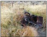
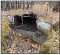
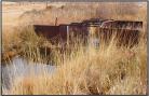
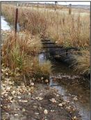
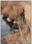
| Diversion: | COOK DITCH DIVERSION AKA: COOK#9, Crazy Woman #9 |
 Cook headgate |
||||||||||||||||||||||||||||||||||||
| Date: | 25 Oct. 2000 | |||||||||||||||||||||||||||||||||||||
| Diversion Description: | Headgate consists of two 3.5 x 4-foot,
rectangular steel gates in steel slides on concrete throat,
raised/lowered by Waterman-type screws beside a concrete dam, all in
excellent condition. |
|||||||||||||||||||||||||||||||||||||
| Diversion Location: | The Cook Ditch diversion is located on the
Little North Fork of the Crazy Woman, a tributary to Crazy Woman Creek,
which itself drains to the Powder River. |
|||||||||||||||||||||||||||||||||||||
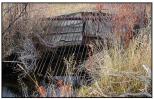
|
 Cook flume |
|||||||||||||||||||||||||||||||||||||
| Conveyance Description: | Open channel canal, approximately 6.0 mi. long.. | |||||||||||||||||||||||||||||||||||||
| Direct Flow Water Rights: |
|
|||||||||||||||||||||||||||||||||||||
| Associated Storage Rights: | Fills Ridge Place #2 Reservoir (7472R) |
|||||||||||||||||||||||||||||||||||||
| Irrigation Practices: | Approximately 60 percent of irrigation is done by
flood from a ditch; the remaining 40 percent is done with a variety of
sprinkler systems. |
|||||||||||||||||||||||||||||||||||||
| Return Flows: | Estimated percentage of total diversion developing into return flows: | |||||||||||||||||||||||||||||||||||||
|
||||||||||||||||||||||||||||||||||||||
| Losses: | Approximately 20 percent | |||||||||||||||||||||||||||||||||||||
| References: | David Pelloux, State Engineer’s Office, Interview, 25 Oct. 2000 | |||||||||||||||||||||||||||||||||||||
Irrigated Lands Water Rights Database
| PerNo | PerSfx | Facility Name | Priority | Acres | Amount | Unit | SupTyp | Status | Source |
|---|---|---|---|---|---|---|---|---|---|
| Terr | D | Cook | 1548 |
15.73 |
CFS | OS | Adj | North Fork Crazy Woman Crk |
|
| Terr | D | Blue Gap (Cook) |
1138 | 19.65 |
CFS | OS | Adj | North Fork Crazy Woman Crk | |
| Terr |
D |
North Fork (Cook, Cross) |
800 | 25 |
CFS | OS | Adj | North Fork Crazy Woman Crk | |
| 1336 |
E | Enl. Cook |
Feb 27, 1905 | 68.5 |
0.97 |
CFS | OS | Adj |
North Fork Crazy Woman Crk |
| 6886 |
D |
Cook |
Sep 18,1905 |
92 |
1.31 |
CFS |
Sec |
Adj |
Corrall Creek
(733R) |
| 22211 |
D |
Fort Collins
(Cook) |
March 20,
1961 |
992.4 |
0 |
SS |
Adj |
LittleNorth Fork Crazy Woman Crk | |
| 22209 |
D |
Fort Collins (Cook) | March 20, 1961 | 992.4 |
14.18 |
CFS |
OS |
Adj |
North Fork Crazy Woman Crk |
| Name Source District Data |
Cook Ditch
Diversion Crazy Woman Creek 2 Total monthly flow in AF |
||||||||||||
| Water Year | Oct | Nov | Dec | Jan | Feb | Mar | Apr | May | Jun | July |
Aug |
Sep |
Total |
|---|---|---|---|---|---|---|---|---|---|---|---|---|---|
| 1970 | |||||||||||||
| 1971 | |||||||||||||
| 1972 | |||||||||||||
| 1973 | |||||||||||||
| 1974 | 658.12 |
21.78 |
679.9 |
||||||||||
| 1975 | |||||||||||||
| 1976 | |||||||||||||
| 1977 | |||||||||||||
| 1978 | |||||||||||||
| 1979 | |||||||||||||
| 1980 | |||||||||||||
| 1981 | 2052.00 |
1176.00 |
730.00 |
500.00 |
318.00 |
4776.00 |
|||||||
| 1982 | 1065.55 |
2593.15 |
1655.71 |
896.17 |
314.29 |
6524.87 |
|||||||
| 1983 | 0.00 |
1770.71 |
1349.16 |
529.08 |
362.13 |
4011.08 |
|||||||
| 1984 | 360.80 |
2368.10 |
1636.03 |
741.17 |
325.65 |
5431.75 |
|||||||
| 1985 | 405.77 |
1215.30 |
1172.05 |
425.89 |
300.05 |
0.00 |
3519.51 |
||||||
| 1986 | 1285.88 |
2252.42 |
896.42 |
569.42 |
343.10 |
5347.24 |
|||||||
| 1987 | 2038.35 |
928.45 |
1282.76 |
677.46 |
198.89 |
5125.91 |
|||||||
| 1988 | 1693.80 |
1359.94 |
320.88 |
18.54 |
0.00 |
3393.16 |
|||||||
| 1989 | 1665.05 |
1579.56 | 947.76 |
347.18 |
107.71 |
4647.26 |
|||||||
| 1990 | 1421.42 | 2565.25 |
989.92 |
524.98 |
39.23 |
5540.80 |
|||||||
| 1991 | 748.98 |
1412.73 |
916.79 |
605.56 |
0.00 |
3684.06 |
|||||||
| 1992 | 1581.61 | 1449.35 |
241.00 |
475.25 |
506.08 |
4253.29 |
|||||||
| 1993 | 1102.83 | 1925.05 | 677.43 | 630.46 | 254.43 | 4590.63 |
|||||||
| 1994 | 1211.12 |
983.22 |
626.00 |
226.29 |
0.00 |
3046.63 |
|||||||
| 1995 | 490.98 |
857.34 |
1000.17 |
639.95 |
251.15 |
3239.59 |
|||||||
| 1996 | 770.93 |
2080.32 |
1094.74 |
472.41 |
255.40 |
4673.80 |
|||||||
| 1997 | 886.97 |
2059.24 |
1274.12 |
146.66 |
295.79 |
4662.78 |
|||||||
| 1998 | 1122.69 |
2105.89 |
1268.27 |
723.35 |
722.83 |
5943.03 |
|||||||
| 1999 | 735.17 |
1431.87 |
997.39 |
565.69 | 490.02 |
4220.14 |
|||||||
| Mean | 20.29 |
1072.47 |
1603.53 |
949.43 |
480.60 |
239.24 |
4365.55 |
||||||
| Max | 405.77 |
2052.00 |
2593.15 |
1655.71 |
896.17 |
722.83 |
6524.87 |
||||||
| Min | 0.00 |
0.00 |
241.00 |
18.54 |
0.00 |
679.9 |
|||||||
| Name Source District Data |
Cook Ditch
Diversion Crazy Woman Creek 2 First & Last Dates, Max. Days |
||
| Water Year | First Date of Measurement | Last Date of Measurement | Maximum Days Missing |
|---|---|---|---|
| 1970 | |||
| 1971 | |||
| 1972 | |||
| 1973 | |||
| 1974 | 08-Jul |
03-Aug |
1 |
| 1975 | |||
| 1976 | |||
| 1977 | |||
| 1978 | |||
| 1979 | |||
| 1980 | |||
| 1981 | 01-May |
30-Sep |
0 |
| 1982 | 03-May | 30-Sep | 7 |
| 1983 | 03-Jun |
23-Sep | 9 |
| 1984 | 25-May | 26-Sep | 6 |
| 1985 | 19-Apr | 29-Aug | 7 |
| 1986 | 01-May | 15-Sep | 11 |
| 1987 | 07-May | 14-Sep | 8 |
| 1988 | 02-May | 03-Aug | 12 |
| 1989 | 01-May | 14-Sep | 8 |
| 1990 | 01-May | 05-Sep | 5 |
| 1991 | 06-May | 28-Aug | 4 |
| 1992 | 04-May | 21-Sep | 14 |
| 1993 | 07-May | 29-Sep | 9 |
| 1994 | 06-May | 22-Aug | 7 |
| 1995 | 01-May | 22-Sep | 29 |
| 1996 | 01-May | 23-Sep | 11 |
| 1997 | 15-May | 29-Sep | 8 |
| 1998 | 16-May | 30-Sep | 11 |
| 1999 | 17-May | 29-Sep | 51 |
| Avg. | 10-May | 13-Sep | 11 |
| Earliest | 19-Apr |
03-Aug | 0 |
| Latest | 08-Jul |
30-Sep | 51 |
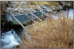
| Diversion: | DEVOE NO.1 DITCH DIVERSION AKA: Dovoe #1, Dove #1, Crazy Woman #21 |
 Devoe No. 1 headgate |
||||||||||||||||||||||||
| Date: | 25 Oct. 2000 | |||||||||||||||||||||||||
| Note: |
The Devoe No. 1 Ditch has a pump
that delivers water to irrigation systems. In addition, 2.15 cfs of the
Teddy Miller Ditch water was transferred to the Devoe No. 1 pump two
years ago. |
|||||||||||||||||||||||||
| Diversion Description: | Headgate consists of a single, 2.5-foot round
steel gate in steel slides, raised/lowered by Waterman-type screw
mounted in a steel slider frame and mounted in a concrete headwall. |
|||||||||||||||||||||||||
| Diversion Location: | The Devoe No. 1 Ditch diverts from the South
Fork of Crazy Woman Creek. |
 Devoe No. 1 flume |
||||||||||||||||||||||||
|
||||||||||||||||||||||||||
| Conveyance Description: | Open channel canal, approximately 5.0 mi. long. | |||||||||||||||||||||||||
| Direct Flow
Water Rights: |
|
|||||||||||||||||||||||||
| See
Note above; 2.14 cfs transferred to Devoe No. 1 for pumping |
||||||||||||||||||||||||||
| Associated Storage Rights: | None | |||||||||||||||||||||||||
| Irrigation Practices: | Of the land under irrigation from the Devoe No. 1
Ditch, 40 percent sprinklers and 60 percent ditch-flood. |
|||||||||||||||||||||||||
| Return Flows: | Estimated percentage of total diversion developing into return flows: | |||||||||||||||||||||||||
|
||||||||||||||||||||||||||
| Losses: |
|
|||||||||||||||||||||||||
Irrigated Lands Water Rights Database
| PerNo | PerSfx | Facility Name | Priority | Acres | Amount | Unit | SupTyp | Status | Source |
|---|---|---|---|---|---|---|---|---|---|
| Terr | D | Devoe No. 1 |
1409.88 |
34.69 |
CFS | OS | Adj | Middle Fork |
|
| Terr | D | Teddy Miller (Devoe No. 1 and No.2) |
355 |
5.07 |
CFS | OS | Adj | Middle Fork |
|
| 23740 |
D | Devoe No. 1 |
Dec 30, 1969 |
361 |
0 |
CFS | OS | Adj | Colorado Flats Draw (7285R) |
| Name Source District Data |
Devoe No. 1
Ditch Diversion Crazy Woman Creek 2 Total monthly flow in AF |
||||||||||||
| Water Year | Oct | Nov | Dec | Jan | Feb | Mar | Apr | May | Jun | Jul | Aug | Sep | Total |
|---|---|---|---|---|---|---|---|---|---|---|---|---|---|
| 1970 | |||||||||||||
| 1971 | |||||||||||||
| 1972 | |||||||||||||
| 1973 | |||||||||||||
| 1974 | 0.00 |
0.00 |
0.00 |
461.57 |
439.16 |
0.00 |
900.73 |
||||||
| 1975 | |||||||||||||
| 1976 | |||||||||||||
| 1977 | |||||||||||||
| 1978 | |||||||||||||
| 1979 | |||||||||||||
| 1980 | |||||||||||||
| 1981 | 0.00 |
814.00 |
668.00 |
404.00 |
399.00 |
336.00 |
2621.00 |
||||||
| 1982 | 0.00 | 460.26 |
859.57 |
611.35 |
295.74 |
58.34 |
2285.26 |
||||||
| 1983 | 0.00 | 252.95 |
1037.56 |
535.28 |
459.96 |
249.88 |
2535.63 |
||||||
| 1984 | 0.00 | 250.39 |
1069.11 |
720.64 |
662.71 |
265.35 |
2968.20 |
||||||
| 1985 | 415.23 |
962.73 |
453.89 |
274.49 |
123.97 |
0.00 |
2230.31 |
||||||
| 1986 | 0.00 | 1371.03 |
987.63 |
537.42 |
305.28 |
0.00 |
3201.36 |
||||||
| 1987 | 0.00 | 822.9 |
883.22 |
481.15 |
651.1 |
0.00 |
2838.37 |
||||||
| 1988 | 0.00 | 1240.88 |
734.40 |
322.94 |
0.00 |
0.00 |
2298.22 |
||||||
| 1989 | 0.00 | 724.88 |
550.30 |
509.88 |
194.89 |
0.00 |
1979.95 |
||||||
| 1990 | 0.00 | 564.11 |
955.45 |
702.35 |
231.93 |
0.00 |
2453.84 |
||||||
| 1991 | 0.00 | 839.20 |
548.09 |
551.82 |
377.41 |
0.00 |
2316.52 |
||||||
| 1992 | 0.00 | 767.53 |
478.72 |
65.98 |
183.87 |
149.02 |
1645.12 |
||||||
| 1993 | 0.00 | 863.14 |
844.90 |
313.85 |
405.09 |
304.93 |
2731.91 |
||||||
| 1994 | 0.00 | 851.60 |
471.73 |
233.64 |
317.19 |
68.64 |
1942.80 |
||||||
| 1995 | 0.00 | 708.50 |
726.73 |
107.86 |
523.06 |
310.85 |
2377.00 |
||||||
| 1996 | 0.00 | 731.07 |
884.72 |
91.83 |
26.58 |
0.00 |
1734.20 |
||||||
| 1997 | 0.00 | 615.94 |
921.35 |
248.61 |
4.71 |
0.00 |
1790.61 |
||||||
| 1998 | 0.00 | 454.91 |
818.06 |
290.10 |
360.77 |
16.04 |
1939.88 |
||||||
| 1999 | 0.00 | 228.07 |
731.83 |
119.60 |
|||||||||
| Mean | 20.76 |
676.20 |
731.26 |
392.88 |
313.81 |
93.93 |
2252.15 |
||||||
| Max | 415.23 |
1371.03 |
1069.11 |
720.64 |
662.71 |
336.00 |
3201.36 |
||||||
| Min | 0.00 | 0.00 | 0.00 | 65.98 |
0.00 | 0.00 | 900.73 |
||||||
| Name Source District Data |
Devoe No.
1 Ditch Diversion Crazy Woman Creek 2 First & Last Dates, Max. Days |
||
| Water Year | First Date of Measurement | Last Date of Measurement | Maximum Days Missing |
|---|---|---|---|
| 1970 | |||
| 1971 | |||
| 1972 | |||
| 1973 | |||
| 1974 | 08-Jun |
28-Aug |
0 |
| 1975 | |||
| 1976 | |||
| 1977 | |||
| 1978 | |||
| 1979 | |||
| 1980 | |||
| 1981 | 01-May |
30-Sep |
0 |
| 1982 | 12-May |
10-Sep |
7 |
| 1983 | 23-May |
14-Sep |
8 |
| 1984 | 25-May |
26-Sep |
10 |
| 1985 | 16-Apr |
14-Aug |
7 |
| 1986 | 01-May |
22-Aug |
11 |
| 1987 | 07-May |
28-Aug |
5 |
| 1988 | 02-May |
26-Jul |
5 |
| 1989 | 01-May |
18-Aug |
5 |
| 1990 | 01-May |
27-Aug |
5 |
| 1991 | 01-May |
28-Aug |
7 |
| 1992 | 04-May |
23-Sep |
49 |
| 1993 | 03-May |
27-Sep |
17 |
| 1994 | 02-May |
21-Sep |
9 |
| 1995 | 01-May |
22-Sep |
20 |
| 1996 | 01-May |
05-Aug |
17 |
| 1997 | 16-May |
04-Aug |
8 |
| 1998 | 16-May |
08-Sep |
26 |
| 1999 | 17-May |
10-Sep |
57 |
| Avg. | 0-May |
02-Sep |
14 |
| Earliest | 16-Apr |
26-Jul |
0 |
| Latest | 08-Jul |
30-Sep |
57 |
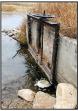
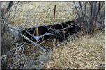
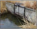
| Diversion: | JOHN R. SMITH DITCH DIVERSION AKA: Crazy Woman #2 |
 John R. Smith Ditch Headgate |
||||||||||||||||||
| Date: | 25 Oct. 2000 | |||||||||||||||||||
| Note: |
This ditch normally dries up Crazy Woman Creek below its headgate. | |||||||||||||||||||
| Diversion Description: | Headgate consists of a single, 3.5 x 3.5-foot, round steel headgate in excellent condition, raised/lowered by Waterman-type screw mounted in a steel slider frame and mounted in a concrete headwall. The downstream dam appears to consist of piled rock. | |||||||||||||||||||
| Diversion Location: | The John R. Smith Ditch diverts from the North
Fork of Crazy Woman, a tributary of Crazy Woman Creek, which in turn
joins the Powder River. |
|||||||||||||||||||
|
 John R. Smith Ditch Flume |
|||||||||||||||||||
| Conveyance Description: | Open channel canal, approximately 5 mi. long. | |||||||||||||||||||
| Direct Flow Water Rights: |
|
|||||||||||||||||||
| Associated Storage Rights: | None | |||||||||||||||||||
| Irrigation Practices: | All of the land irrigated by this ditch is under
ditch-flood irrigation. |
|||||||||||||||||||
| Return Flows: | Estimated percentage of total diversion developing into return flows: | |||||||||||||||||||
|
||||||||||||||||||||
| Losses: | Approximately 20 percent by the end of the ditch | |||||||||||||||||||
| References: | Dave Pelloux, Interview, State Engineer’s Office, 25 Oct. 2000 | |||||||||||||||||||
Irrigated Lands Water Rights Database
| PerNo | PerSfx | Facility Name | Priority | Acres | Amount | Unit | SupTyp | Status | Source |
|---|---|---|---|---|---|---|---|---|---|
| Terr |
D |
John R. Smith |
1200 |
17.14 |
CFS | OS | Adj | Crazy Woman Creek |
|
| Terr |
D |
Mitchell & Long (John R Smith) |
1200 |
20 |
CFS |
OS | Adj | Crazy Woman Creek |
|
| 5149 |
E |
Enl. John R. Smith |
May 8, 1935 |
350 |
5 |
CFS | OS | Adj | Crazy Woman Creek |
| 5150 |
E |
Enl. John R. Smith |
May 8, 1935 |
350 |
0 |
SS | Adj | Stage Draw or School Section Draw |
| Name Source District Data |
John R.
Smith Ditch Diversion Crazy Woman Creek 2 Total monthly flow in AF |
||||||||||||
| Water Year | Oct | Nov | Dec | Jan | Feb | Mar | Apr | May | Jun | Jul | Aug | Sep | Total |
|---|---|---|---|---|---|---|---|---|---|---|---|---|---|
| 1970 | |||||||||||||
| 1971 | |||||||||||||
| 1972 | |||||||||||||
| 1973 | |||||||||||||
| 1974 | 0.00 |
0.00 |
0.00 |
252.10 |
764.37 |
0.00 |
1016.47 |
||||||
| 1975 | |||||||||||||
| 1976 | |||||||||||||
| 1977 | |||||||||||||
| 1978 | |||||||||||||
| 1979 | |||||||||||||
| 1980 | |||||||||||||
| 1981 | 0.00 |
612.00 |
1863.00 |
815.00 |
579.00 |
132.00 |
4001.00 |
||||||
| 1982 | 0.00 |
1277.05 |
1855.95 |
1278.28 |
583.76 |
0.00 |
4995.04 |
||||||
| 1983 | 0.00 |
2890.98 |
1801.57 |
1355.78 |
608.53 |
0.00 |
6656.86 |
||||||
| 1984 | 0.00 |
1079.28 |
1635.68 |
1586.17 |
1114.18 |
797.17 |
6212.48 |
||||||
| 1985 | 1243.96 |
1119.46 |
1015.99 |
659.79 |
828.05 |
1848.62 |
6715.87 |
||||||
| 1986 | 0.00 |
1271.21 |
1243.56 |
716.67 |
681.29 |
280.47 |
4193.20 |
||||||
| 1987 | 0.00 |
1245.66 |
1302.76 |
1084.31 |
681.81 |
307.05 |
4621.59 |
||||||
| 1988 | 0.00 |
1117.50 |
850.11 |
465.64 |
766.49 |
397.15 |
3596.89 |
||||||
| 1989 | 0.00 |
1143.00 |
1490.10 |
576.15 |
480.44 |
27.62 |
3717.31 |
||||||
| 1990 | 0.00 |
974.00 |
1021.58 |
766.95 |
950.18 |
124.22 |
3836.93 |
||||||
| 1991 | 0.00 |
1130.38 |
892.93 |
942.92 |
584.70 |
0.00 |
3550.93 |
||||||
| 1992 | 0.00 |
905.93 |
1429.70 |
818.10 |
766.58 |
384.11 |
4304.42 |
||||||
| 1993 | 0.00 |
1601.75 |
351.02 |
369.53 |
917.64 |
35.91 |
3275.85 |
||||||
| 1994 | 0.00 |
1410.50 |
967.20 |
757.49 |
455.35 |
419.13 |
4009.67 |
||||||
| 1995 | 0.00 |
1320.60 |
1297.59 |
505.50 |
839.88 |
334.59 |
4298.16 |
||||||
| 1996 | 0.00 |
1534.65 |
731.41 |
1125.43 |
1078.26 |
224.43 |
4694.18 |
||||||
| 1997 | 0.00 |
759.14 |
330.60 |
265.70 |
124.26 |
38.08 |
1517.78 |
||||||
| 1998 | 0.00 |
1008.32 |
592.24 |
575.36 |
1205.14 |
19.41 |
3400.47 |
||||||
| 1999 | 0.00 |
770.61 |
867.59 |
708.60 |
590.52 |
348.30 |
3285.62 |
||||||
| Mean | 62.20 |
1158.60 |
1077.03 |
781.27 |
730.02 |
285.91 |
4095.04 |
||||||
| Max | 1243.96 |
2890.98 |
1863.00 |
1586.17 |
1205.14 |
1848.62 |
6715.87 |
||||||
| Min | 0.00 |
0.00 | 0.00 | 252.10 | 124.26 |
0.00 |
1016.47 |
||||||
| Name Source District Data |
John R. Smith Ditch Diversion Crazy Woman Creek 2 First & Last Dates, Max. Days |
||
| Water Year | First Date of Measurement | Last Date of Measurement | Maximum Days Missing |
|---|---|---|---|
| 1970 | |||
| 1971 | |||
| 1972 | |||
| 1973 | |||
| 1974 | 11-Jul |
30-Aug |
0 |
| 1975 | |||
| 1976 | |||
| 1977 | |||
| 1978 | |||
| 1979 | |||
| 1980 | |||
| 1981 | 01-May |
11-Sep |
0 |
| 1982 | 03-May |
13-Aug |
7 |
| 1983 | 01-May |
19-Aug |
15 |
| 1984 | 09-May |
24-Sep |
6 |
| 1985 | 04-Apr |
30-Sep |
8 |
| 1986 | 01-May |
15-Sep |
11 |
| 1987 | 07-May |
14-Sep |
10 |
| 1988 | 02-May |
15-Sep |
6 |
| 1989 | 01-May |
05-Sep |
5 |
| 1990 | 01-May |
05-Sep |
5 |
| 1991 | 01-May |
28-Aug |
11 |
| 1992 | 04-May |
23-Sep |
24 |
| 1993 | 03-May |
03-Sep |
7 |
| 1994 | 02-May |
30-Sep |
14 |
| 1995 | 01-May |
22-Sep |
35 |
| 1996 | 01-May |
30-Sep |
24 |
| 1997 | 16-May |
15-Sep |
44 |
| 1998 | 16-May |
02-Sep |
7 |
| 1999 | 17-May |
29-Sep |
51 |
| Avg. | 06-May |
11-Sep |
15 |
| Earliest | 04-Apr |
13-Aug |
0 |
| Latest | 11-Jul |
30-Sep |
51 |
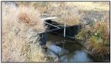
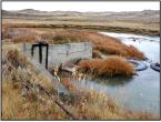
| Diversion: | KENNEDY DITCH DIVERSION AKA: Crazy Woman #16 |
 Kennedy headgates |
||||||||||||||||||
| Date: | 25 Oct. 2000 | |||||||||||||||||||
| Diversion Description: | Headgate consists of a single, 3.5 x 3.5-foot
round steel headgate in good condition, raised/lowered by a
Waterman-type screw mounted on steel slides in a concrete headwall. |
|||||||||||||||||||
| Diversion Location: | The Kennedy Ditch diverts from the North Fork of
Crazy Woman, a tributary of Crazy Woman Creek, which in turn joins the
Powder River. |
|||||||||||||||||||
|
 Kennedy flume |
|||||||||||||||||||
| Conveyance Description: | Approximately 2 miles long, includes one mile of
underground pipe (Kennedy pipeline right comes from larger Kennedy
Ditch right) |
|||||||||||||||||||
| Direct Flow Water Rights: | The direct-flow rights summary follows:
|
|||||||||||||||||||
| Associated Storage Rights: |
Fills reservoirs 7305R and 6417R.
Irrigators on the Kennedy Ditch also use water from Muddy Guard No. 2
Reservoir. |
|||||||||||||||||||
| Irrigation Practices: | Irrigators use approximately one-third side-roll
and pivot sprinklers, one-third gated pipe, and one-third ditch flood
irrigation. |
|||||||||||||||||||
| Return Flows: | Estimated percentage of total diversion developing into return flows: | |||||||||||||||||||
|
||||||||||||||||||||
| Losses: | Typical (10 percent) by the end of the ditch | |||||||||||||||||||
| References: | Dave Pelloux, interview, State Engineer’s Office, 25 Oct. 2000 | |||||||||||||||||||
Irrigated Lands Water Rights Database
| PerNo | PerSfx | Facility Name | Priority | Acres | Amount | Unit | SupTyp | Status | Source |
|---|---|---|---|---|---|---|---|---|---|
| Terr |
D |
Kennedy |
307.66 |
32 |
CFS | OS | Adj | North Fork Crazy Woman Creek |
|
| 5935 |
E |
Enl. Kennedy |
May 17, 1956 |
79.8 |
0 |
SS | Adj | North Fork Crazy Woman Creek |
| Name Source District Data |
Kennedy
Ditch Diversion Crazy Woman Creek 2 Total monthly flow in AF |
||||||||||||
| Water Year | Oct | Nov | Dec | Jan | Feb | Mar | Apr | May | Jun | Jul | Aug | Sep | Total |
|---|---|---|---|---|---|---|---|---|---|---|---|---|---|
| 1970 | |||||||||||||
| 1971 | |||||||||||||
| 1972 | |||||||||||||
| 1973 | |||||||||||||
| 1974 | 0.00 |
0.00 |
0.00 |
231.61 |
125.39 |
0.00 |
357.00 |
||||||
| 1975 | |||||||||||||
| 1976 | |||||||||||||
| 1977 | |||||||||||||
| 1978 | |||||||||||||
| 1979 | |||||||||||||
| 1980 | |||||||||||||
| 1981 | 0.00 |
1062.00 |
1066.00 |
973.00 |
470.00 |
360.00 |
3931.00 |
||||||
| 1982 | 0.00 |
72.02 |
1209.56 |
959.09 |
933.90 |
210.54 |
3385.11 |
||||||
| 1983 | 0.00 |
51.86 |
1257.87 |
1102.25 |
760.71 |
118.03 |
3290.72 |
||||||
| 1984 | 0.00 |
363.08 |
1315.41 |
410.65 |
1396.31 |
548.03 |
4033.48 |
||||||
| 1985 | 147.63 |
737.24 |
808.99 |
296.01 |
256.04 |
0.00 |
2245.91 |
||||||
| 1986 | 0.00 |
1126.44 |
1149.97 |
672.98 |
489.22 |
28.56 |
3467.17 |
||||||
| 1987 | 0.00 |
494.82 |
630.80 |
505.77 |
574.43 |
126.21 |
2332.03 |
||||||
| 1988 | 0.00 |
587.20 |
500.97 |
483.47 |
95.88 |
0.00 |
1667.52 |
||||||
| 1989 | 0.00 |
641.30 |
534.79 |
366.55 |
396.80 |
53.37 |
1992.81 |
||||||
| 1990 | 0.00 |
348.83 |
784.37 |
739.64 |
583.16 |
62.08 |
2518.08 |
||||||
| 1991 | 0.00 |
141.67 |
980.19 |
370.11 |
644.26 |
0.00 |
2136.23 |
||||||
| 1992 | 0.00 |
792.29 |
673.81 |
509.84 |
505.50 |
166.38 |
2647.82 |
||||||
| 1993 | 0.00 |
623.13 |
274.68 |
301.95 |
697.47 |
244.19 |
2141.42 |
||||||
| 1994 | 0.00 |
445.77 |
756.52 |
356.77 |
338.77 |
176.92 |
2074.75 |
||||||
| 1995 | 0.00 |
93.83 |
291.10 |
723.26 |
749.55 |
418.79 |
2276.53 |
||||||
| 1996 | 0.00 |
582.53 |
1204.71 |
675.50 |
438.60 |
125.27 |
3026.61 |
||||||
| 1997 | 0.00 |
674.57 |
736.4 |
581.18 |
417.54 |
580.78 |
2990.81 |
||||||
| 1998 | 0.00 |
446.66 |
1029.33 |
823.34 |
726.93 |
372.08 |
3398.34 |
||||||
| 1999 | 0.00 |
176.73 |
1041.07 |
631.64 |
780.05 |
310.41 |
2939.90 |
||||||
| Mean | 7.38 |
473.10 |
812.34 |
585.73 |
569.03 |
195.08 |
2642.66 |
||||||
| Max | 147.63 |
1126.44 |
1315.41 |
1102.25 |
1396.31 |
580.78 |
4033.48 |
||||||
| Min | 0.00 |
0.00 | 0.00 | 231.61 |
95.88 |
0.00 | 357.00 |
||||||
| Name Source District Data |
Kennedy
Ditch Diversion Crazy Woman Creek 2 First & Last Dates, Max. Days |
||
| Water Year | First Date of Measurement | Last Date of Measurement | Maximum Days Missing |
|---|---|---|---|
| 1970 | |||
| 1971 | |||
| 1972 | |||
| 1973 | |||
| 1974 | 08-Jul |
30-Aug |
0 |
| 1975 | |||
| 1976 | |||
| 1977 | |||
| 1978 | |||
| 1979 | |||
| 1980 | |||
| 1981 | 01-May |
30-Sep |
0 |
| 1982 | 03-May |
17-Sep |
10 |
| 1983 | 23-May |
14-Sep |
8 |
| 1984 | 22-May |
26-Sep |
7 |
| 1985 | 19-Apr |
29-Aug |
17 |
| 1986 | 01-May |
15-Sep |
11 |
| 1987 | 07-May |
14-Sep |
8 |
| 1988 | 02-May |
15-Aug |
6 |
| 1989 | 01-May |
14-Sep |
8 |
| 1990 | 01-May |
05-Sep |
15 |
| 1991 | 28-May |
28-Aug |
10 |
| 1992 | 04-May |
23-Sep |
7 |
| 1993 | 03-May |
22-Sep |
12 |
| 1994 | 11-May |
30-Sep |
9 |
| 1995 | 15-May |
22-Sep |
29 |
| 1996 | 10-May |
23-Sep |
9 |
| 1997 | 15-May |
26-Sep |
8 |
| 1998 | 16-May |
30-Sep |
7 |
| 1999 | 17-May | 29-Sep |
51 |
| Avg. | 11-May |
15-Sep |
12 |
| Earliest | 19-Apr |
15-Aug |
0 |
| Latest | 08-Jul |
30-Sep |
51 |
| Diversion: | MITCHELL & LONG DITCH DIVERSION AKA: Crazy Woman #26 |
 Mitchell & Long headgate |
||||||||||||||||||
| Date: | 25 Oct. 2000 | |||||||||||||||||||
| Diversion Description: | Headgate consists of a single, 3 x 3-foot round
steel headgate in good condition, raised/lowered by Waterman-type screw
mounted in a steel slider frame and mounted in a concrete headwall. Dam
consists of truck tires and tarp. |
|||||||||||||||||||
| Diversion Location: | The Mitchell & Long Ditch diverts from the
North Fork of Crazy Woman, a tributary of Crazy Woman Creek, which in
turn joins the Powder River. |
|||||||||||||||||||
|
 Mitchell & Long flume |
|||||||||||||||||||
| Conveyance Description: | Open channel canal, approximately 3.5 mi. long. | |||||||||||||||||||
| Direct Flow Water Rights: | The direct-flow rights summary follows:
|
|||||||||||||||||||
| Associated Storage Rights: | Fills Zezas reservoir (7285R) |
|||||||||||||||||||
| Irrigation Practices: | All of the land irrigated by this ditch is under
ditch-flood irrigation. |
|||||||||||||||||||
| Return Flows: | Estimated percentage of total diversion developing into return flows: | |||||||||||||||||||
|
||||||||||||||||||||
| Losses: | Approximately 20 percent by the end of the ditch | |||||||||||||||||||
| References: | Dave Pelloux, interview, State Engineer’s Office, 25 Oct. 2000 | |||||||||||||||||||
Irrigated Lands Water Rights Database
| PerNo | PerSfx | Facility Name | Priority | Acres | Amount | Unit | SupTyp | Status | Source |
|---|---|---|---|---|---|---|---|---|---|
| Terr |
D |
Mitchell & Long (John R. Smith) |
1200 |
20 |
CFS |
OS |
Adj |
Crazy Woman Creek |
|
| 23741 |
D |
Mitchell & Long |
Dec 30, 1969 |
416 |
0 |
Sec |
Adj |
Crazy Woman Crek/Colorado Flats Draw (7285R) |
| Name Source District Data |
Mitchell
& Long Ditch Diversion Crazy Woman Creek 2 Total monthly flow in AF |
||||||||||||
| Water Year | Oct | Nov | Dec | Jan | Feb | Mar | Apr | May | Jun | Jul | Aug | Sep | Total |
|---|---|---|---|---|---|---|---|---|---|---|---|---|---|
| 1970 | |||||||||||||
| 1971 | |||||||||||||
| 1972 | |||||||||||||
| 1973 | |||||||||||||
| 1974 | 0.00 |
0.00 |
0.00 |
27.07 |
443.01 |
0.00 |
470.08 |
||||||
| 1975 | |||||||||||||
| 1976 | |||||||||||||
| 1977 | |||||||||||||
| 1978 | |||||||||||||
| 1979 | |||||||||||||
| 1980 | |||||||||||||
| 1981 | 0.00 |
1059.00 |
1564.00 |
664.00 |
267.00 |
130.00 |
3684.00 |
||||||
| 1982 | 0.00 |
794.38 |
794.80 |
698.22 |
796.40 |
126.20 |
3210.00 |
||||||
| 1983 | 0.00 |
653.68 |
476.70 |
1000.25 |
717.01 |
128.50 |
2976.14 |
||||||
| 1984 | 0.00 |
615.52 |
550.91 |
543.56 |
300.48 |
463.80 |
2474.27 |
||||||
| 1985 | 432.90 |
507.00 |
291.93 |
300.35 |
123.97 |
0.00 |
1656.15 |
||||||
| 1986 | 0.00 |
384.51 |
549.71 |
525.26 |
194.12 |
176.05 |
1829.65 |
||||||
| 1987 | 0.00 |
293.68 |
601.59 |
550.66 |
410.50 |
46.59 |
1903.02 |
||||||
| 1988 | 0.00 |
586.85 |
249.84 |
211.58 |
7.11 |
0.00 |
1055.38 |
||||||
| 1989 | 0.00 |
481.13 |
851.59 |
369.36 |
356.08 |
72.55 |
2130.71 |
||||||
| 1990 | 0.00 |
490.96 |
501.12 |
534.32 |
97.06 |
0.00 |
1623.46 |
||||||
| 1991 | 0.00 |
632.37 |
727.75 |
445.76 |
229.59 |
0.00 |
2035.47 |
||||||
| 1992 | 0.00 |
478.02 |
680.14 |
428.68 |
90.77 |
0.00 |
1677.61 |
||||||
| 1993 | 0.00 |
508.89 |
229.30 |
268.60 |
376.78 |
106.36 |
1489.93 |
||||||
| 1994 | 0.00 |
435.48 |
184.83 |
381.07 |
103.46 |
0.00 |
1104.84 |
||||||
| 1995 | 0.00 |
333.02 |
711.47 |
360.71 |
548.72 |
280.96 |
2234.88 |
||||||
| 1996 | 0.00 |
1009.76 |
320.12 |
336.43 |
725.51 |
52.60 |
2444.42 |
||||||
| 1997 | 0.00 |
713.60 |
387.66 |
1207.58 |
0.00 |
0.00 |
2308.84 |
||||||
| 1998 | 0.00 |
770.26 |
99.71 |
1319.59 |
1235.41 |
246.14 |
3671.11 |
||||||
| 1999 | 0.00 |
523.64 |
408.06 |
779.44 |
638.39 |
90.55 |
2440.08 |
||||||
| Mean | 21.65 |
563.59 |
509.06 |
547.62 |
383.07 |
96.02 |
2121.00 |
||||||
| Max | 432.90 |
1059.00 |
1564.00 |
1319.59 |
1235.41 |
463.80 |
3684.00 |
||||||
| Min | 0.00 |
0.00 | 0.00 | 27.07 |
0.00 | 0.00 | 470.08 |
||||||
| Name Source District Data |
Mitchell
& Long Ditch Diversion Crazy Woman Creek 2 First & Last Dates, Max. Days |
||
| Water Year | First Date of Measurement | Last Date of Measurement | Maximum Days Missing |
|---|---|---|---|
| 1970 | |||
| 1971 | |||
| 1972 | |||
| 1973 | |||
| 1974 | 11-Jul |
28-Aug |
0 |
| 1975 | |||
| 1976 | |||
| 1977 | |||
| 1978 | |||
| 1979 | |||
| 1980 | |||
| 1981 | 01-May |
30-Sep |
0 |
| 1982 | 03-May |
16-Sep |
7 |
| 1983 | 16-May |
23-Sep |
25 |
| 1984 | 14-May |
26-Sep |
18 |
| 1985 | 04-Apr |
14-Aug |
14 |
| 1986 | 01-May |
12-Sep |
20 |
| 1987 | 19-May |
08-Sep |
9 |
| 1988 | 02-May |
03-Aug |
6 |
| 1989 | 01-May |
14-Sep |
9 |
| 1990 | 01-May |
06-Aug |
5 |
| 1991 | 01-May |
28-Aug |
5 |
| 1992 | 04-May |
07-Aug |
14 |
| 1993 | 03-May |
13-Sep |
16 |
| 1994 | 06-May |
08-Aug |
15 |
| 1995 | 10-May |
22-Sep |
35 |
| 1996 | 01-May |
03-Sep |
21 |
| 1997 | 16-May |
30-Jul |
44 |
| 1998 | 16-May |
14-Sep |
9 |
| 1999 | 17-May |
07-Sep |
51 |
| Avg. | 08-May |
01-Sep |
16 |
| Earliest | 04-Apr |
30-Jul |
0 |
| Latest | 11-Jul |
30-Sep |
51 |
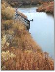
| Diversion: | MORETON DITCH DIVERSION AKA: Merton, Morton, Crazy Woman #8 |
 Moreton headgate |
||||||||||||||||||
| Date: | 25 Oct. 2000 | |||||||||||||||||||
| Diversion Description: | Headgate consists of a single, 3.3 x 2.3-foot
rectangular steel gate in steel slides, raised/lowered by a
Waterman-type screw mounted in a steel slider frame and mounted in a
concrete headwall. |
|||||||||||||||||||
| Diversion Location: | The Moreton Ditch diverts from the Middle Fork
of Crazy Woman, a tributary of Crazy Woman Creek, which in turn joins
the Powder River. |
|||||||||||||||||||
|
 Moreton flume |
|||||||||||||||||||
| Conveyance Description: | Open channel canal, approximately 1.5 mi. long, to pressurized pipes. | |||||||||||||||||||
| Direct Flow Water Rights: |
|
|||||||||||||||||||
| Associated Storage Rights: | The Moreton fills Case and Glen Means reservoirs (5886R and 9697R). | |||||||||||||||||||
| Irrigation Practices: | All of the land irrigated by this ditch is under
side-roll sprinkler irrigation. |
|||||||||||||||||||
| Return Flows: | Estimated percentage of total diversion developing into return flows: | |||||||||||||||||||
|
||||||||||||||||||||
| Losses: | Approximately 10 percent by the end of the ditch | |||||||||||||||||||
| References: | David Pelloux, Interview, State Engineer’s Office, 25 Oct. 2000 | |||||||||||||||||||
Irrigated Lands Water Rights Database
| PerNo | PerSfx | Facility Name | Priority | Acres | Amount | Unit | SupTyp | Status | Source |
|---|---|---|---|---|---|---|---|---|---|
| Terr |
D |
Moreton |
252 |
14.02 |
CFS |
OS |
Adj |
Middle Fork Crazy Woman Creek |
| Name Source District Data |
Moreton
Ditch Diversion Crazy Woman Creek 2 Total monthly flow in AF |
||||||||||||
| Water Year | Oct | Nov | Dec | Jan | Feb | Mar | Apr | May | Jun | Jul | Aug | Sep | Total |
|---|---|---|---|---|---|---|---|---|---|---|---|---|---|
| 1970 | |||||||||||||
| 1971 | |||||||||||||
| 1972 | |||||||||||||
| 1973 | |||||||||||||
| 1974 | 0.00 |
0.00 |
16.07 |
112.84 |
0.00 |
0.00 |
128.91 |
||||||
| 1975 | |||||||||||||
| 1976 | |||||||||||||
| 1977 | |||||||||||||
| 1978 | |||||||||||||
| 1979 | |||||||||||||
| 1980 | |||||||||||||
| 1981 | 0.00 |
139.70 |
377.26 |
173.50 |
231.20 |
23.08 |
944.74 |
||||||
| 1982 | 0.00 |
442.46 |
289.33 |
108.41 |
|||||||||
| 1983 | 0.00 |
1109.61 |
220.30 |
146.22 |
455.29 |
0.00 |
1931.42 |
||||||
| 1984 | |||||||||||||
| 1985 | 251.42 |
380.38 |
395.19 |
315.84 |
465.28 |
0.00 |
1808.11 |
||||||
| 1986 | 0.00 |
191.20 |
437.76 |
347.35 |
323.14 |
217.06 |
1516.51 |
||||||
| 1987 | 0.00 |
624.75 |
197.52 |
159.15 |
208.21 |
33.18 |
1222.81 |
||||||
| 1988 | 0.00 |
572.36 |
248.51 |
242.62 |
0.00 |
0.00 |
1063.49 |
||||||
| 1989 | 0.00 |
357.95 |
336.35 |
137.17 |
166.58 |
100.47 |
1098.52 |
||||||
| 1990 | 0.00 |
246.62 |
556.76 |
486.03 |
221.93 |
12.50 |
1523.84 |
||||||
| 1991 | 0.00 |
232.82 |
279.93 |
196.32 |
189.51 |
0.00 |
898.58 |
||||||
| 1992 | 0.00 |
424.92 |
35.01 |
53.76 |
325.28 |
193.29 |
1059.26 |
||||||
| 1993 | 0.00 |
230.96 |
131.09 |
149.39 |
209.47 |
460.76 |
1181.67 |
||||||
| 1994 | 0.00 |
216.14 |
|||||||||||
| 1995 | 0.00 |
113.67 |
29.02 |
25.65 |
63.06 |
0.00 |
231.40 |
||||||
| 1996 | 0.00 |
173.90 |
256.33 |
272.56 |
0.00 |
0.00 |
702.79 |
||||||
| 1997 | 0.00 |
70.15 |
410.73 |
300.19 |
172.80 |
393.10 |
1346.97 |
||||||
| 1998 | 0.00 |
17.38 |
118.20 |
308.32 |
279.68 |
111.04 |
834.62 |
||||||
| 1999 | 0.00 |
30.82 |
224.99 |
225.92 |
79.09 |
0.00 |
560.82 |
||||||
| Mean | 13.23 |
293.46 |
251.24 |
214.87 |
205.94 |
91.83 |
1062.03 |
||||||
| Max | 251.42 |
1109.61 |
556.76 |
486.03 |
465.28 |
460.76 |
1931.42 |
||||||
| Min | 0.00 |
0.00 | 16.07 |
25.65 |
0.00 | 0.00 | 128.91 |
||||||
| Name Source District Data |
Moreton
Ditch Diversion Crazy Woman Creek 2 First & Last Dates, Max. Days |
||
| Water Year | First Date of Measurement | Last Date of Measurement | Maximum Days Missing |
|---|---|---|---|
| 1970 | |||
| 1971 | |||
| 1972 | |||
| 1973 | |||
| 1974 | 28-Jun |
31-Jul |
0 |
| 1975 | |||
| 1976 | |||
| 1977 | |||
| 1978 | |||
| 1979 | |||
| 1980 | |||
| 1981 | 13-May |
11-Sep |
30 |
| 1982 | 03-May |
30-Sep |
57 |
| 1983 | 01-May |
29-Aug |
17 |
| 1984 | 04-Jun |
29-Aug |
56 |
| 1985 | 19-Apr |
29-Aug |
7 |
| 1986 | 01-May |
15-Sep |
22 |
| 1987 | 07-May |
14-Sep |
9 |
| 1988 | 04-May |
22-Jul |
20 |
| 1989 | 01-May |
14-Sep |
28 |
| 1990 | 01-May |
05-Sep |
10 |
| 1991 | 20-May |
28-Aug |
23 |
| 1992 | 04-May |
23-Sep |
49 |
| 1993 | 03-May |
29-Sep |
21 |
| 1994 | 06-May |
30-Sep |
84 |
| 1995 | 01-May |
21-Aug |
26 |
| 1996 | 10-May |
15-Jul |
17 |
| 1997 | 16-May |
29-Sep |
40 |
| 1998 | 16-May |
30-Sep |
20 |
| 1999 | 17-May |
01-Sep |
51 |
| Avg. | 10-May |
04-Sep |
29 |
| Earliest | 19-Apr |
15-Jul |
0 |
| Latest | 28-Jun |
30-Sep |
84 |
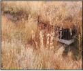
| Diversion: | NORTH FORK DITCH DIVERSION AKA: North Fork #3, Crazy Woman #3 |
 North Fork headgate |
||||||||||||||||||||||||||||||||||||
| Date: | 25 Oct. 2000 | |||||||||||||||||||||||||||||||||||||
| Diversion Description: | Headgate consists of a single, 3.5 x 2-foot
rectangular steel gate set in steel slides in a sheet metal and
wood-reinforced headwall, all protected by a welded steel trash rack. |
|||||||||||||||||||||||||||||||||||||
| Diversion Location: | The North Fork Ditch diverts from the North Fork
of Crazy Woman, a tributary of Crazy Woman Creek, which in turn joins
the Powder River. |
 North Fork flume |
||||||||||||||||||||||||||||||||||||
|
||||||||||||||||||||||||||||||||||||||
| Conveyance Description: | Open channel canal, approximately 1.5 mi. long. | |||||||||||||||||||||||||||||||||||||
| Direct Flow Water Rights: |
|
|||||||||||||||||||||||||||||||||||||
| Associated Storage Rights: | Fills reservoirs 7305R and 6417R. Irrigators on
the North Fork Ditch also use Muddy Guard No. 2 reservoir water. |
|||||||||||||||||||||||||||||||||||||
| Irrigation Practices: | Irrigators use approximately one-third side-roll
and pivot sprinklers, one-third gated pipe, and one-third ditch flood
irrigation. |
|||||||||||||||||||||||||||||||||||||
| Return Flows: | Estimated percentage of total diversion developing into return flows: | |||||||||||||||||||||||||||||||||||||
|
||||||||||||||||||||||||||||||||||||||
| Losses: | Approximately 10 percent |
|||||||||||||||||||||||||||||||||||||
| References: |
Dave Pelloux, State Engineer's
Office, Interview, 25 Oct. 2000 |
|||||||||||||||||||||||||||||||||||||
Irrigated Lands Water Rights Database
| PerNo | PerSfx | Facility Name | Priority | Acres | Amount | Unit | SupTyp | Status | Source |
|---|---|---|---|---|---|---|---|---|---|
| Terr |
D |
North Fork (Cook, Cross) |
800 |
30 |
CFS |
OS |
Adj |
North Fork Crazy Woman Creek |
|
| Terr |
D |
North Fork |
800 |
30 |
CFS |
OS |
Adj |
North Fork Crazy Woman Creek |
|
| Terr |
D |
North Fork |
300 |
30 |
CFS |
OS |
Adj |
North Fork Crazy Woman Creek |
|
| 6193 |
E |
Enl. North Fork Crazy Woman Creek |
Nov 23, 1962 |
25.9 |
0.37 |
CFS |
OS |
Adj |
North Fork Crazy Woman Creek |
| 6356 |
E |
Enl. North Fork |
April 6, 1970 |
60.5 |
0.87 |
CFS |
OS |
Adj |
North Fork Crazy Woman Creek |
| Name Source District Data |
North Fork
Ditch Diversion Crazy Woman Creek 2 Total monthly flow in AF |
||||||||||||
| Water Year | Oct | Nov | Dec | Jan | Feb | Mar | Apr | May | Jun | Jul | Aug | Sep | Total |
|---|---|---|---|---|---|---|---|---|---|---|---|---|---|
| 1970 | |||||||||||||
| 1971 | |||||||||||||
| 1972 | |||||||||||||
| 1973 | |||||||||||||
| 1974 | 0.00 |
0.00 |
0.00 |
383.46 |
0.00 |
383.46 |
|||||||
| 1975 | |||||||||||||
| 1976 | |||||||||||||
| 1977 | |||||||||||||
| 1978 | |||||||||||||
| 1979 | |||||||||||||
| 1980 | |||||||||||||
| 1981 | 273.61 |
550.51 |
294.26 |
64.05 |
0.00 |
1182.43 |
|||||||
| 1982 | 0.00 |
68.46 |
224.15 |
137.00 |
35.15 |
464.76 |
|||||||
| 1983 | 0.00 |
261.13 |
277.61 |
232.71 |
211.31 |
982.76 |
|||||||
| 1984 | 112.77 |
286.67 |
216.48 |
210.81 |
0.00 |
826.73 | |||||||
| 1985 | 313.02 |
302.22 |
287.28 |
291.69 |
357.84 |
1552.05 |
|||||||
| 1986 | 215.53 |
165.60 |
423.47 |
241.96 |
132.11 |
1178.67 |
|||||||
| 1987 | 36.02 |
128.99 |
198.86 |
78.55 |
0.00 |
442.42 |
|||||||
| 1988 | 0.00 |
0.00 |
269.25 |
186.38 |
62.38 |
518.01 |
|||||||
| 1989 | 78.30 |
158.84 |
116.25 |
158.29 |
85.32 |
597.00 |
|||||||
| 1990 | 78.14 |
220.89 |
179.49 |
151.14 |
16.17 |
645.83 |
|||||||
| 1991 | 94.92 |
72.50 |
88.94 |
291.59 |
0.00 |
547.95 |
|||||||
| 1992 | 200.48 |
36.46 |
|||||||||||
| 1993 | 281.05 |
116.05 |
221.21 |
154.17 |
237.37 |
1009.85 |
|||||||
| 1994 | 122.00 |
115.99 |
262.18 |
163.49 |
98.71 |
762.37 |
|||||||
| 1995 | 0.00 |
0.00 |
0.00 |
270.93 |
242.69 |
513.62 |
|||||||
| 1996 | 339.92 |
259.42 |
283.02 |
388.42 |
245.69 |
1516.47 |
|||||||
| 1997 | 237.17 |
266.66 |
219.99 |
73.10 |
250.10 |
1047.02 |
|||||||
| 1998 | 245.19 |
283.42 |
386.64 |
519.86 |
420.15 |
1855.26 |
|||||||
| 1999 | 49.46 |
179.04 |
440.16 |
501.79 |
112.17 |
1282.62 |
|||||||
| Mean | 133.88 |
180.86 |
231.01 |
236.81 |
127.18 |
911.01 |
|||||||
| Max | 339.92 |
550.51 |
440.16 |
519.86 |
420.15 |
1855.26 |
|||||||
| Min | 0.00 |
0.00 |
0.00 |
64.05 |
0.00 |
383.46 |
|||||||
| Name Source District Data |
North Fork
Ditch Diversion Crazy Woman Creek 2 First & Last Dates, Max. Days |
||
| Water Year | First Date of Measurement | Last Date of Measurement | Maximum Days Missing |
|---|---|---|---|
| 1970 | |||
| 1971 | |||
| 1972 | |||
| 1973 | |||
| 1974 | 07-Aug |
30-Aug |
0 |
| 1975 | |||
| 1976 | |||
| 1977 | |||
| 1978 | |||
| 1979 | |||
| 1980 | |||
| 1981 | 20-May |
07-Aug |
35 |
| 1982 | 25-Jun |
07-Sep |
12 |
| 1983 | 15-Jun |
23-Sep |
23 |
| 1984 | 22-May |
31-Aug |
39 |
| 1985 | 01-May |
30-Sep |
24 |
| 1986 | 01-May |
15-Sep |
28 |
| 1987 | 26-May |
19-Aug |
21 |
| 1988 | 07-Jul |
15-Sep |
19 |
| 1989 | 10-May |
14-Sep |
8 |
| 1990 | 25-May |
05-Sep |
12 |
| 1991 | 24-May |
28-Aug |
46 |
| 1992 | 04-May |
08-Sep |
76 |
| 1993 | 10-May |
29-Sep |
30 |
| 1994 | 11-May |
30-Sep |
30 |
| 1995 | 07-Aug |
22-Sep |
10 |
| 1996 | 01-May |
30-Sep |
16 |
| 1997 | 15-May |
29-Sep |
30 |
| 1998 | 16-May |
30-Sep |
7 |
| 1999 | 17-May |
13-Sep |
51 |
| Avg. | 28-May |
13-Sep |
26 |
| Earliest | 01-May |
07-Aug |
0 |
| Latest | 07-Aug |
30-Sep |
76 |
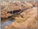
| Diversion: | PX DITCH DIVERSION AKA: Crazy Woman #12 |
 PX Ditch headgate |
||||||||||||||||||
| Date: | 25 Oct. 2000 | |||||||||||||||||||
| Diversion Description: | Headgate consists of a single, 4 x 3.5-foot
rectangular steel gate in steel slides, raised/lowered by Waterman-type
screw mounted in a steel slider frame and mounted in a concrete
headwall. |
|||||||||||||||||||
| Diversion Location: | The PX Ditch diverts from Muddy Creek, a
tributary of Crazy Woman Creek, which in turn joins the Powder River. |
|||||||||||||||||||
|
 PX Ditch flume |
|||||||||||||||||||
| Conveyance Description: | Open channel canal, approximately 1.0 mi. long, with approximately 1/3 mile of the ditch piped under Muddy Creek. | |||||||||||||||||||
| Direct Flow Water Rights: |
|
|||||||||||||||||||
| Associated Storage Rights: | None | |||||||||||||||||||
| Irrigation Practices: | Of the land under irrigation from the PX Ditch,
40 percent is under sprinklers, 40 percent is flooded from gate pipes,
and the remaining 20 percent is flooded from ditches.
|
|||||||||||||||||||
| Return Flows: | Estimated percentage of total diversion developing into return flows: | |||||||||||||||||||
|
||||||||||||||||||||
| Losses: | Approximately 5 percent by the end of the ditch | |||||||||||||||||||
| References: | Dave Pelloux, Interview, State Engineer’s Office, 25 Oct. 2000 | |||||||||||||||||||
Irrigated Lands Water Rights Database
| PerNo | PerSfx | Facility Name | Priority | Acres | Amount | Unit | SupTyp | Status | Source |
|---|---|---|---|---|---|---|---|---|---|
| Terr |
D |
PX |
200 |
17.9 |
CFS |
OS |
Adj |
Muddy Creek |
|
| 17669 |
D |
Mitten (PX) |
Feb 26, 1930 |
270.5 |
3.86 |
CFS |
OS |
Adj |
Muddy Creek |
| 7081 |
E |
ENL P X |
Dec 8, 1993 |
319.5 |
4.57 |
CFS |
OS |
Una |
Muddy Creek |
| Name Source District Data |
PX Ditch
Diversion Crazy Woman Creek 2 Total monthly flow in AF |
||||||||||||
| Water Year | Oct | Nov | Dec | Jan | Feb | Mar | Apr | May | Jun | Jul | Aug | Sep | Total |
|---|---|---|---|---|---|---|---|---|---|---|---|---|---|
| 1970 | |||||||||||||
| 1971 | |||||||||||||
| 1972 | |||||||||||||
| 1973 | |||||||||||||
| 1974 | |||||||||||||
| 1975 | |||||||||||||
| 1976 | |||||||||||||
| 1977 | |||||||||||||
| 1978 | |||||||||||||
| 1979 | |||||||||||||
| 1980 | |||||||||||||
| 1981 | 0.00 |
0.00 |
0.00 |
188.29 |
0.00 |
0.00 |
188.29 |
||||||
| 1982 | 0.00 |
74.12 |
350.61 |
263.27 |
51.18 |
0.00 |
739.18 |
||||||
| 1983 | 0.00 |
0.00 |
133.52 |
207.14 |
115.67 |
48.07 |
504.40 |
||||||
| 1984 | |||||||||||||
| 1985 | 62.06 |
133.98 |
308.31 |
129.00 |
58.41 |
0.00 |
691.76 |
||||||
| 1986 | 0.00 |
58.64 |
257.54 |
227.43 |
87.84 |
103.23 |
734.68 |
||||||
| 1987 | 0.00 |
120.67 |
60.31 |
135.64 |
85.52 |
0.00 |
402.14 |
||||||
| 1988 | 0.00 |
126.67 |
239.91 |
63.77 |
0.00 |
0.00 |
430.35 |
||||||
| 1989 | 0.00 |
37.89 |
96.12 |
90.43 |
280.87 |
0.00 |
505.31 |
||||||
| 1990 | 0.00 |
131.97 |
158.47 |
211.93 |
0.00 |
0.00 |
502.37 |
||||||
| 1991 | |||||||||||||
| 1992 | 0.00 |
126.04 |
0.00 |
||||||||||
| 1993 | 0.00 |
13.69 |
|||||||||||
| 1994 | 0.00 |
218.29 |
79.91 |
208.55 |
0.00 |
0.00 |
506.75 |
||||||
| 1995 | 0.00 |
20.85 |
370.54 |
581.28 |
208.11 |
122.41 |
1303.19 |
||||||
| 1996 | 0.00 |
334.29 |
293.00 |
230.62 |
101.04 |
0.00 |
958.95 |
||||||
| 1997 | 0.00 |
255.71 |
277.65 |
352.09 |
318.58 |
379.71 |
1583.74 |
||||||
| 1998 | 0.00 |
280.11 |
319.50 |
323.52 |
105.95 |
330.56 |
1359.64 |
||||||
| 1999 | 0.00 |
38.12 |
282.25 |
||||||||||
| Mean | 3.65 |
122.33 |
210.39 |
229.50 |
100.94 |
75.29 |
743.63 |
||||||
| Max | 62.06 |
334.29 |
370.54 |
581.28 |
318.58 |
379.71 |
1583.74 |
||||||
| Min | 0.00 |
0.00 | 0.00 | 63.77 |
0.00 | 0.00 | 188.29 |
||||||
| Name Source District Data |
PX
Ditch Diversion Crazy Woman Creek 2 First & Last Dates, Max. Days |
||
| Water Year | First Date of Measurement | Last Date of Measurement | Maximum Days Missing |
|---|---|---|---|
| 1970 | |||
| 1971 | |||
| 1972 | |||
| 1973 | |||
| 1974 | |||
| 1975 | |||
| 1976 | |||
| 1977 | |||
| 1978 | |||
| 1979 | |||
| 1980 | |||
| 1981 | 10-Jul |
20-Jul |
3 |
| 1982 | 17-May |
11-Aug |
26 |
| 1983 | 20-Jun |
14-Sep |
5 |
| 1984 | 04-Jun |
31-Aug |
54 |
| 1985 | 04-Apr |
12-Aug |
25 |
| 1986 | 01-May |
15-Sep |
42 |
| 1987 | 07-May |
19-Aug |
45 |
| 1988 | 04-May |
13-Jul |
7 |
| 1989 | 19-May |
01-Sep |
42 |
| 1990 | 07-May |
27-Jul |
14 |
| 1991 | |||
| 1992 | 11-May |
24-Aug |
54 |
| 1993 | 03-May |
03-Sep |
77 |
| 1994 | 02-May |
01-Aug |
42 |
| 1995 | 30-May |
18-Sep |
29 |
| 1996 | 01-May |
12-Aug |
18 |
| 1997 | 15-May |
24-Sep |
8 |
| 1998 | 16-May |
30-Sep |
11 |
| 1999 | 17-May |
29-Sep |
72 |
| Avg. | 15-May |
25-Aug |
32 |
| Earliest | 04-Apr |
13-Jul |
3 |
| Latest | 10-Jul |
30-Sep |
77 |
| Diversion: | TEDDY MILLER DITCH DIVERSION |
 Teddy Miller headgate |
|||||||||||||
| Date: | 26 Oct. 2000 | ||||||||||||||
| Note: |
The majority of the water
adjudicated to the Teddy Miller Ditch in the 19th century has been
reduced in the past two years as part of a transfer. In the process of
executing the transfer, the owner abandoned 806 acres of land claimed
under the original right. The current ditch has a right to 0.52 cfs.
The water transfer moved the point of use for 2.15 cfs to Devoe No. 1
and 2.4 cfs to Devoe No. 2. |
||||||||||||||
| Diversion Description: | Headgate consists of a 2.0-foot(round steel gate
in steel slides, raised/lowered by a Waterman-type screw, mounted in a
concrete headwall. |
||||||||||||||
| Diversion Location: | The Teddy Miller Ditch diverts from the main
stem of Crazy Woman Creek. |
||||||||||||||
|
|||||||||||||||
| Conveyance Description: | Open channel canal, approximately 1.0 mi. long. | ||||||||||||||
| Direct Flow Water Rights: |
|
||||||||||||||
| See Note above. This table is
provided for reference to the State Engineer’s Office Tabulation of
Adjudicated Surface Water Rights of the State of Wyoming, Water
Division Number Two, Oct. 1999. The Teddy Miller Ditch currently has a
right to 0.52 cfs. |
|||||||||||||||
| Associated Storage Rights: | None | ||||||||||||||
| Irrigation Practices: | Of the land under irrigation from the Teddy
Miller Ditch, all of the water is delivered by ditch-flood. Much of the
right is used for stock watering. |
||||||||||||||
| Return Flows: | Estimated percentage of total diversion developing into return flows: | ||||||||||||||
|
|||||||||||||||
| Losses: | Approximately 5 percent by the end of the ditch |
||||||||||||||
| References: |
Dave Pelloux, State Engineer's
Office, Interview, 25 Oct.2000 |
||||||||||||||
Irrigated Lands Water Rights Database
| PerNo | PerSfx | Facility Name | Priority | Acres | Amount | Unit | SupTyp | Status | Source |
|---|---|---|---|---|---|---|---|---|---|
| Terr |
D |
Teddy Miller (Devoe No. 1 and No. 2) |
355 |
5.07 |
CFS |
OS |
Adj |
Middle Fork Crazy Woman Creek |
| Name Source District Data |
Teddy
Miller Ditch Diversion Crazy Woman Creek 2 Total monthly flow in AF |
||||||||||||
| Water Year | Oct | Nov | Dec | Jan | Feb | Mar | Apr | May | Jun | Jul | Aug | Sep | Total |
|---|---|---|---|---|---|---|---|---|---|---|---|---|---|
| 1970 | |||||||||||||
| 1971 | |||||||||||||
| 1972 | |||||||||||||
| 1973 | |||||||||||||
| 1974 | 0.00 |
0.00 |
0.00 |
98.84 |
9.52 |
0.00 |
108.36 |
||||||
| 1975 | |||||||||||||
| 1976 | |||||||||||||
| 1977 | |||||||||||||
| 1978 | |||||||||||||
| 1979 | |||||||||||||
| 1980 | |||||||||||||
| 1981 | 0.00 |
0.00 |
228.00 |
180.00 |
41.00 |
0.00 |
449.00 |
||||||
| 1982 | 0.00 |
602.24 |
278.41 |
121.18 |
234.42 |
217.30 |
1453.55 |
||||||
| 1983 | 0.00 |
136.92 |
389.52 |
589.61 |
300.23 |
113.26 |
1529.54 |
||||||
| 1984 | 0.00 |
0.00 |
405.31 |
254.46 |
215.77 |
0.00 |
875.54 |
||||||
| 1985 | 504.27 |
546.05 |
639.96 |
38.81 |
0.00 |
0.00 |
1729.09 |
||||||
| 1986 | 0.00 |
165.88 |
890.76 |
375.20 |
45.62 |
0.00 |
1477.46 |
||||||
| 1987 | 0.00 |
253.94 |
256.13 |
107.75 |
201.30 |
0.00 |
819.12 |
||||||
| 1988 | 0.00 | 356.82 |
79.82 |
0.00 |
0.00 |
0.00 |
436.64 |
||||||
| 1989 | 0.00 | 422.78 |
191.52 |
199.42 |
117.78 |
87.85 |
1019.35 |
||||||
| 1990 | 0.00 | 621.76 |
235.05 |
377.69 |
243.67 |
12.50 |
1490.67 |
||||||
| 1991 | 0.00 | 256.57 |
397.88 |
283.07 |
153.98 |
0.00 |
1091.50 |
||||||
| 1992 | 0.00 | 294.57 |
82.17 |
154.54 |
287.92 |
144.13 |
963.33 |
||||||
| 1993 | 0.00 | 363.87 |
216.58 |
330.23 |
306.15 |
115.09 |
1331.92 |
||||||
| 1994 | 0.00 | 838.43 |
427.22 |
||||||||||
| 1995 | 0.00 | 237.14 |
319.15 |
143.68 |
317.17 |
169.24 |
1186.38 |
||||||
| 1996 | 0.00 | 286.19 |
254.30 |
399.44 |
294.61 |
151.32 |
1385.86 |
||||||
| 1997 | 0.00 | 218.94 |
356.21 |
412.70 |
370.73 |
178.47 |
1537.05 |
||||||
| 1998 | 0.00 | 156.34 |
136.29 |
157.74 |
98.23 |
114.76 |
663.36 |
||||||
| 1999 | 0.00 | 47.80 |
251.06 |
92.42 |
36.65 |
50.58 |
478.51 |
||||||
| Mean | 25.21 |
290.31 |
301.77 |
227.20 |
172.36 |
71.29 |
1054.01 |
||||||
| Max | 504.27 |
838.43 |
890.76 |
589.61 |
370.73 |
217.30 |
1729.09 |
||||||
| Min | 0.00 | 0.00 | 0.00 | 0.00 | 0.00 | 0.00 | 108.36 | ||||||
| Name Source District Data |
Teddy Miller
Ditch Diversion Crazy Woman Creek 2 First & Last Dates, Max. Days |
||
| Water Year | First Date of Measurement | Last Date of Measurement | Maximum Days Missing |
|---|---|---|---|
| 1970 | |||
| 1971 | |||
| 1972 | |||
| 1973 | |||
| 1974 | 08-Jul |
25-Aug |
0 |
| 1975 | |||
| 1976 | |||
| 1977 | |||
| 1978 | |||
| 1979 | |||
| 1980 | |||
| 1981 | 01-Jun |
07-Aug |
0 |
| 1982 | 03-May |
30-Aug |
37 |
| 1983 | 23-May |
14-Sep |
8 |
| 1984 | 04-Jun |
29-Aug |
5 |
| 1985 | 08-Apr |
13-Jul |
10 |
| 1986 | 23-May |
08-Aug |
6 |
| 1987 | 07-May |
21-Aug |
11 |
| 1988 | 02-May |
27-Jun |
20 |
| 1989 | 01-May |
14-Sep |
26 |
| 1990 | 01-May |
05-Sep |
5 |
| 1991 | 01-May |
28-Aug |
6 |
| 1992 | 04-May |
23-Sep |
45 |
| 1993 | 10-May |
29-Sep |
14 |
| 1994 | 02-May |
30-Sep |
79 |
| 1995 | 01-May |
22-Sep |
20 |
| 1996 | 01-May |
30-Sep |
12 |
| 1997 | 16-May |
29-Sep |
9 |
| 1998 | 16-May |
30-Sep |
9 |
| 1999 | 17-May |
29-Sep |
51 |
| Avg. | 12-May |
05-Sep |
19 |
| Earliest | 08-Apr |
27-Jun |
0 |
| Latest | 08-Jul |
30-Sep |
79 |
| Diversion: | THOMPSON & MATTHEWS DITCH DIVERSION AKA: Crazy Woman #25 |
 Thompson & Matthews Headgate |
||||||||||||||
| Date: | 25 Oct. 2000 | |||||||||||||||
| Diversion Description: | Headgate consists of two 2 x 3.5-foot
rectangular steel gates in steel slides on a concrete throat,
raised/lowered by Waterman-type screws. |
|||||||||||||||
| Diversion Location: | The Thompson & Matthews diversion draws from
the North Fork of Crazy Woman, tributary of Crazy Woman Creek, which in
turn joins the Powder River. |
|||||||||||||||
|
 Thompson & Matthews flume |
|||||||||||||||
| Conveyance Description: | Open channel canal, approximately 2.0 mi. long. |
|||||||||||||||
| Direct Flow Water Rights: |
|
|||||||||||||||
| Associated Storage Rights: | Fills reservoir Muddy Guard #2 through
approximately 1 mile of Muddy Creek. |
|||||||||||||||
| Irrigation Practices: | Irrigators use approximately 50 percent
side-roll sprinklers, 50 percent gated pipe flood irrigation. |
|||||||||||||||
| Return Flows: | Estimated percentage of total diversion developing into return flows: | |||||||||||||||
|
||||||||||||||||
| Losses: | Thanks to the fine soil makeup in the ditch, it's losses are low, approximately 5 percent | |||||||||||||||
| References: | Dave Pelloux, State Engineer’s Office, interview, 25 Oct. 2000 | |||||||||||||||
Irrigated Lands Water Rights Database
| PerNo | PerSfx | Facility Name | Priority | Acres | Amount | Unit | SupTyp | Status | Source |
|---|---|---|---|---|---|---|---|---|---|
| Terr |
D |
Thompson & Matthews |
800 |
12 |
CFS |
OS |
Adj |
North Fork Crazy Woman Creek |
| Name Source District Data |
Thompson
& Matthews Ditch Diversion Crazy Woman Creek 2 Total monthly flow in AF |
||||||||||||
| Water Year | Oct | Nov | Dec | Jan | Feb | Mar | Apr | May | Jun | Jul | Aug | Sep | Total |
|---|---|---|---|---|---|---|---|---|---|---|---|---|---|
| 1970 | |||||||||||||
| 1971 | |||||||||||||
| 1972 | |||||||||||||
| 1973 | |||||||||||||
| 1974 | |||||||||||||
| 1975 | |||||||||||||
| 1976 | |||||||||||||
| 1977 | |||||||||||||
| 1978 | |||||||||||||
| 1979 | |||||||||||||
| 1980 | |||||||||||||
| 1981 | 0.00 |
1116.39 |
0.00 |
||||||||||
| 1982 | 0.00 |
1534.54 |
371.14 |
308.88 |
228.35 |
99.14 |
2542.05 |
||||||
| 1983 | 0.00 |
1873.22 |
469.74 |
236.01 |
0.00 |
0.00 |
2578.97 |
||||||
| 1984 | 0.00 |
804.38 |
780.01 |
116.48 |
0.00 |
0.00 |
1700.87 |
||||||
| 1985 | 455.30 |
244.55 |
102.96 |
6.19 |
|||||||||
| 1986 | 0.00 |
1031.15 |
185.23 |
0.00 |
0.00 |
0.00 |
1216.38 |
||||||
| 1987 | 0.00 |
453.33 |
140.59 |
0.00 |
0.00 |
0.00 |
593.92 |
||||||
| 1988 | 0.00 |
452.32 |
268.17 |
0.00 |
0.00 |
0.00 |
720.49 |
||||||
| 1989 | 0.00 |
619.30 |
911.27 |
106.19 |
0.00 |
0.00 |
1636.76 |
||||||
| 1990 | 0.00 |
630.90 |
299.15 |
282.98 |
233.48 |
26.28 |
1472.79 |
||||||
| 1991 | 0.00 |
390.53 |
305.17 |
307.54 |
0.00 |
0.00 |
1003.24 |
||||||
| 1992 | 0.00 |
291.29 |
403.80 |
0.00 |
0.00 |
0.00 |
695.09 |
||||||
| 1993 | 0.00 |
161.50 |
|||||||||||
| 1994 | 0.00 |
281.89 |
125.81 |
89.73 |
0.00 |
0.00 |
497.43 |
||||||
| 1995 | 0.00 |
812.41 |
475.31 |
0.00 |
0.00 |
0.00 |
1287.72 |
||||||
| 1996 | 0.00 |
926.49 |
37.90 |
48.44 |
0.00 |
0.00 |
1012.83 |
||||||
| 1997 | 0.00 |
742.99 |
297.79 |
73.83 |
104.63 |
59.15 |
1278.39 |
||||||
| 1998 | 0.00 |
258.46 |
488.97 |
406.20 |
9.91 |
0.00 |
1163.54 |
||||||
| 1999 | 0.00 |
14.41 |
105.79 |
129.84 |
46.30 |
0.00 |
296.34 |
||||||
| Mean | 23.96 |
693.25 |
339.34 |
131.63 |
38.92 |
18.54 |
1231.05 |
||||||
| Max | 455.30 |
1873.22 |
911.27 |
406.20 |
233.48 |
161.50 |
2578.97 |
||||||
| Min | 0.00 |
14.41 |
37.90 |
0.00 | 0.00 | 0.00 | 296.34 |
||||||
| Name Source District Data |
Thompson
& Matthews Ditch Diversion Crazy Woman Creek 2 First & Last Dates, Max. Days |
||
| Water Year | First Date of Measurement | Last Date of Measurement | Maximum Days Missing |
|---|---|---|---|
| 1970 | |||
| 1971 | |||
| 1972 | |||
| 1973 | |||
| 1974 | |||
| 1975 | |||
| 1976 | |||
| 1977 | |||
| 1978 | |||
| 1979 | |||
| 1980 | |||
| 1981 | 18-May |
21-Aug |
66 |
| 1982 | 03-May |
17-Sep |
35 |
| 1983 | 01-May |
29-Jul |
15 |
| 1984 | 25-May |
16-Jul |
7 |
| 1985 | 04-Apr |
03-Sep |
56 |
| 1986 | 01-May |
20-Jun |
11 |
| 1987 | 07-May |
15-Jun |
4 |
| 1988 | 04-May |
27-Jun |
5 |
| 1989 | 05-May |
13-Jul |
7 |
| 1990 | 01-May |
05-Sep |
7 |
| 1991 | 01-May |
26-Jul |
7 |
| 1992 | 04-May |
16-Jun |
6 |
| 1993 | 03-May |
29-Sep |
100 |
| 1994 | 02-May |
11-Jul |
20 |
| 1995 | 01-May |
29-Jun |
20 |
| 1996 | 01-May |
15-Jul |
27 |
| 1997 | 15-May |
29-Sep |
8 |
| 1998 | 16-May |
03-Aug |
9 |
| 1999 | 17-May |
01-Sep |
51 |
| Avg. | 05-May |
01-Aug |
24 |
| Earliest | 04-Apr |
15-Jun |
4 |
| Latest | 25-May |
29-Sep |
100 |
| Diversion: | THOMPSON BROTHERS DITCH DIVERSION AKA: Crazy Woman #24 |
 Thompson Brothers headgate |
||||||||||||||
| Date: | 25 Oct. 2000 | |||||||||||||||
| Diversion Description: | Headgate consists of a single, 3 x 2.5-foot
rectangular steel gate in steel slides, raised/lowered by a
Waterman-type screw mounted in a steel slider frame and mounted in a
concrete headwall. |
|||||||||||||||
| Diversion Location: | The Thompson Brothers Ditch diverts from Muddy
Creek, a tributary of Crazy Woman Creek, which in turn joins the Powder
River. |
|||||||||||||||
|
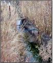 Thompson Brothers flume |
|||||||||||||||
| Conveyance Description: | Open channel canal, approximately 1 mi. long. | |||||||||||||||
| Direct Flow Water Rights: |
|
|||||||||||||||
| Associated Storage Rights: | None | |||||||||||||||
| Irrigation Practices: | All of the land irrigated by this diversion is
under ditch-flood irrigation. |
|||||||||||||||
| Return Flows: | Estimated percentage of total diversion developing into return flows: | |||||||||||||||
|
||||||||||||||||
| Losses: | Approximately 5 percent by the end of the ditch | |||||||||||||||
| References: | Dave Pelloux, State Engineer’s Office, Interview, 25 Oct. 2000 | |||||||||||||||
Irrigated Lands Water Rights Database
| PerNo | PerSfx | Facility Name | Priority | Acres | Amount | Unit | SupTyp | Status | Source |
|---|---|---|---|---|---|---|---|---|---|
| Terr |
D |
Thompson Bros. |
160 |
17.3 |
CFS |
OS |
Adj |
Muddy Creek |
| Name Source District Data |
Thompson
Brothers Ditch Diversion Crazy Woman Creek 2 Total monthly flow in AF |
||||||||||||
| Water Year | Oct | Nov | Dec | Jan | Feb | Mar | Apr | May | Jun | Jul | Aug | Sep | Total |
|---|---|---|---|---|---|---|---|---|---|---|---|---|---|
| 1970 | |||||||||||||
| 1971 | |||||||||||||
| 1972 | |||||||||||||
| 1973 | |||||||||||||
| 1974 | |||||||||||||
| 1975 | |||||||||||||
| 1976 | |||||||||||||
| 1977 | |||||||||||||
| 1978 | |||||||||||||
| 1979 | |||||||||||||
| 1980 | |||||||||||||
| 1981 | |||||||||||||
| 1982 | 0.00 |
607.28 |
478.33 |
0.00 |
0.00 |
1085.61 |
|||||||
| 1983 | 0.00 |
0.00 |
31.58 |
101.31 |
40.41 |
173.30 |
|||||||
| 1984 | 0.00 |
0.00 |
0.00 |
150.77 |
114.86 |
265.63 |
|||||||
| 1985 | 74.84 |
77.60 |
0.00 |
0.00 |
0.00 |
152.44 |
|||||||
| 1986 | 105.34 |
238.86 |
81.16 |
26.59 |
0.00 |
451.95 |
|||||||
| 1987 | 158.06 |
0.00 |
|||||||||||
| 1988 | 235.80 |
11.18 |
0.00 |
0.00 |
0.00 |
246.98 |
|||||||
| 1989 | 119.11 |
0.00 |
0.00 |
0.00 |
0.00 |
119.11 |
|||||||
| 1990 | |||||||||||||
| 1991 | 57.83 |
128.92 |
64.17 |
48.83 |
0.00 |
299.75 |
|||||||
| 1992 | 104.72 |
0.00 |
0.00 |
0.00 |
0.00 |
104.72 |
|||||||
| 1993 | 0.00 |
134.64 |
0.00 |
0.00 |
0.00 |
134.64 |
|||||||
| 1994 | 100.62 |
49.84 |
0.00 |
0.00 |
0.00 |
150.46 |
|||||||
| 1995 | 8.52 |
252.80 |
21.74 |
0.00 |
0.00 |
283.06 |
|||||||
| 1996 | 0.00 |
0.00 |
0.00 |
0.00 |
0.00 |
0.00 |
|||||||
| 1997 | 30.74 |
0.00 |
0.00 |
0.00 |
0.00 |
30.74 |
|||||||
| 1998 | 97.72 |
199.04 |
122.22 |
0.00 |
0.00 |
418.98 |
|||||||
| 1999 | |||||||||||||
| Mean | 68.33 |
113.34 |
53.28 |
21.83 |
9.70 |
261.16 |
|||||||
| Max | 235.80 |
607.28 |
478.33 |
150.77 |
114.86 |
1085.61 |
|||||||
| Min | 0.00 | 0.00 | 0.00 | 0.00 | 0.00 | 0.00 | |||||||
| Name Source District Data |
Thompson
Brothers Ditch Diversion Crazy Woman Creek 2 First & Last Dates, Max. Days |
||
| Water Year | First Date of Measurement | Last Date of Measurement | Maximum Days Missing |
|---|---|---|---|
| 1970 | |||
| 1971 | |||
| 1972 | |||
| 1973 | |||
| 1974 | |||
| 1975 | |||
| 1976 | |||
| 1977 | |||
| 1978 | |||
| 1979 | |||
| 1980 | |||
| 1981 | |||
| 1982 | 01-Jun |
30-Jul |
49 |
| 1983 | 29-Jul |
14-Sep |
23 |
| 1984 | 06-Aug |
24-Sep |
6 |
| 1985 | 15-May |
20-Jun |
4 |
| 1986 | 12-May |
08-Aug |
8 |
| 1987 | 07-May |
31-Aug |
61 |
| 1988 | 04-May |
02-Jun |
5 |
| 1989 | 01-May |
24-May |
3 |
| 1990 | 02-May |
01-Aug |
65 |
| 1991 | 24-May |
21-Aug |
44 |
| 1992 | 04-May |
01-Jun |
5 |
| 1993 | 01-Jun |
18-Jun |
8 |
| 1994 | 16-May |
13-Jun |
6 |
| 1995 | 30-May |
07-Jul |
20 |
| 1996 | No Flow |
No Flow |
No Flow |
| 1997 | 15-May |
29-May |
11 |
| 1998 | 16-May |
27-Jul |
7 |
| 1999 | 17-May |
20-Sep |
119 |
| Avg. | 24-May |
19-Jul |
26 |
| Earliest | 01-May |
24-May |
3 |
| Latest | 06-Aug |
24-Sep |
119 |