Wyoming State Water Plan
Wyoming State Water Plan
Wyoming Water Development Office
6920 Yellowtail Rd
Cheyenne, WY 82002
Phone: 307-777-7626

Wyoming Water Development Office
6920 Yellowtail Rd
Cheyenne, WY 82002
Phone: 307-777-7626


| SUBJECT: |
Appendix U Water Quality Issues |
| PREPARED BY: | HKM Engineering Inc. |
| DATE: | February 2002 |
INTRODUCTION
The purpose of this water quality memorandum is to identify ongoing watershed management planning efforts, define opportunities for potential cooperation and coordination among these efforts, and identify water quality issues within the Northeast Wyoming River Basins Planning Area. Groundwater quality is addressed separately in the Available Groundwater Determination Memorandum (HKM 2002).
Background
The quality of water refers to its physical, chemical, radiological, biological and bacteriological properties. The concentration levels of various constituents within the water dictate the potential uses of a water source. Quality of a water source can be impacted by natural processes or by human actions. The success of a water development project is dependent on the ability of the source to meet the water quality needs of the proposed uses. In addition, the project itself must protect existing and potential uses of waters of the state and adhere to interstate salinity standards.
The major factors affecting the Northeast Wyoming River Basins' water quality are characterized in Appendix A.
Statutory Bases
The State of Wyoming passed enabling legislation known as the Environmental Quality Act in 1973. The purpose of the law was directed at the concern that pollution "will imperil public health and welfare, create public and private nuisances, be harmful to wildlife, fish and aquatic life, and impair domestic, agricultural, industrial, recreational and other beneficial uses." The declared policy of the law was to enable the state "to prevent, reduce and eliminate pollution; to preserve and enhance the water and reclaim the land of Wyoming; to plan development, use, reclamation, preservation and enhancement of the air, land, and water resources of the state; to preserve and exercise the primary responsibilities and rights of the State of Wyoming; to secure cooperation between agencies of the state, agencies of the other states, interstate agencies, and federal government in carrying out these objectives" (Environmental Quality Act, 35-11-102).
The Water Quality Division (WQD) of the Department of Environmental Quality (DEQ) is the designated state agency for water quality management in the State of Wyoming. The WQD has developed a large number of water quality protection programs. These programs deal with point sources (PS) and non-point sources (NPS) of pollution and their potential impacts on surface water and groundwater. Appendix B contains a synopsis of those programs and some federal programs regulating areas not covered by the DEQ or where Wyoming does not have primacy over the federal program.
The federal government has provided many authorities to protect and clean up water quality and the environment. Examples of these authorities include the Clean Water Act, Safe Drinking Water Act, Federal Insecticide, Fungicide and Rodenticide Act, Pollution Prevention Act, National Environmental Protection Act, Solid Waste Disposal Act, Toxic Substance Control Act, Clean Air Act, and others. Most of the federal programs dealing with water quality allow the states to obtain primacy to administer the federal programs. But even if a state has primacy for a federal program, the U.S. Environmental Protection Agency (EPA) has the ability to take action if a state is not administering a program to the federal agency's satisfaction. And in some cases, the EPA is required to intercede if a state fails to take appropriate action.
EXISTING WATER QUALITY STANDARDS: SURFACE WATER
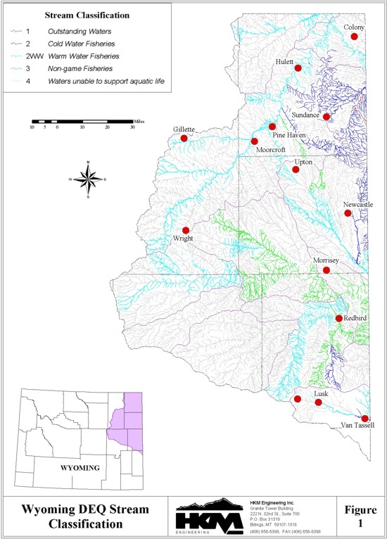
As a result of the Environmental Quality Act, the WQD developed and implemented surface water quality standards contained in Chapter 1, Wyoming Water Quality Rules and Regulations in 1974 (updated in 2001). Chapter 1 contains numerical and narrative standards to establish effluent limitations for those discharges requiring control via permits to discharge in the case of point sources and best management practices in the case of nonpoint sources. The water quality standards apply to all periods of flow conditions as described in Section 4 of Chapter 1.
The stream classes are broken into four major classes with various subcategories within each class.
Appendix A of Chapter 1 of the Wyoming Water Quality Rules and Regulations contains a listing of the classification of all surface water named on the USGS 1:500,000 Hydrologic Map of Wyoming. The current stream classifications of the Northeast Wyoming River Basins are included as part of this study and are illustrated in Figure 1.
States are required to report on specific designated uses (identified in the EPA 1998 305(b) Guidelines), including aquatic life support, primary contact recreation (swimming), fish consumption, and drinking water supply.
ONGOING WATER QUALITY PROGRAMS
Department of Environmental Quality: Total Maximum Daily Loads
The 1972 Clean Water Act requires states to designate Total Maximum Daily Loads (TMDLs) for pollutants in impaired water bodies. The DEQ determines impairment based on whether a water body can meet the designated uses assigned to it in its current state (and level of pollutants). The DEQ provides a good description of the program and its recent history on its web site:
A Total Maximum Daily Load (TMDL) is the amount of pollutant which a stream can accept and still meet its designated uses. TMDLs must be established for each pollutant which is a source of stream impairment. They must be measurable and must consider both point and nonpoint source pollutant loads, natural background conditions, and a margin of safety.The DEQ has recently increased surface water monitoring to address 1999 amendments to the Environmental Quality Act under W.S. 35-11-103(c) and 302(b) directed at "credible data." A program developed in 1993, dubbed the Beneficial Use Reconnaissance Program (BURP), has been generating stream water quality data around Wyoming for four years. Unfortunately, staffing constraints in the agency have restricted the movement of the data through quality assurance/quality control (QA/QC) efforts and into reports. According to DEQ BURP staff, the agency has performed its QA/QC on data collected through 1998, though reports on those data are still pending (Eisenhauer, 13 Dec. 2001).Section 303(d) of the Clean Water Act requires states to:
1) Identify all waters of the state which are impaired--i.e. they contain pollutants which adversely affect the designated use of the water.
2) Prioritize all impaired waterbodies for development of TMDLs. Prioritization is to take into consideration public health and environmental risk. Therefore, point source discharges generally are a higher priority than nonpoint sources of clean sediment.
3) Establish and adopt TMDLs for all impaired waterbodies or for waterbodies which would be impaired if a TMDL was not established.
If a state does not comply with Section 303(d), the Environmental Protection Agency is required to perform these activities.
Every two years, the state must evaluate its water quality data, and submit an updated impaired water body list to the Environmental Protection Agency (EPA) for approval. This list is generated from the Statewide Water Quality Assessment (also known as the 305(b) Report) which also must be submitted every two years. Due to the lack of water quality data available, the Water Quality Division began using surveys in 1990 to determine stream status. These surveys were sent to Conservation Districts, U.S. Forest Service, BLM, Game and Fish, etc. The "professional judgment" of these entities was utilized to place streams on the impaired water body list (also known as the 303(d) list). In addition to waters which are actually impaired, the state must list those waters for which a TMDL will be established within the next two years. Therefore, the state also lists streams which have discharge permits due for renewal and which require a wasteload allocation (approximately 150 of the state's facilities with discharge permits have wasteload allocations).
The state has provided public notice and has submitted the 303(d) list to EPA, as required by the Clean Water Act, since 1990. Since the early 1980's the state has established TMDLs for point source discharges, where necessary, to achieve in-stream designated uses. We anticipate that approximately 5% of these dischargers may be affected by nonpoint source contributions of similar pollutants (such as fecal coliforms or ammonia). In 1989, the State adopted a Nonpoint Source Management Plan to address nonpoint sources of pollution. Under this voluntary program, the state provides Clean Water Act Section 319 funds to local entities for projects which address nonpoint source pollution. Though never formally adopted as a TMDL, many of these projects are comprehensive watershed plans which contain all the components of a TMDL.
On December 9, 1996, Sierra Club Legal Defense Fund, on behalf of Wyoming Outdoor Council, Biodiversity Associates, and American Wildlands, filed a lawsuit in Denver Federal Court to require Region VIII EPA to implement the TMDL program in Wyoming. The litigants claim that the state has not adequately monitored its streams, has not listed all impaired streams, and has not developed sufficient point or nonpoint source TMDLs. The EPA filed for, and was granted, a change of venue. The case is assigned to the federal court in Casper. The Wyoming Association of Conservation Districts has intervened in the lawsuit. Suits involving twenty-eight states are in some stage of litigation and settlement over TMDLs. Although Wyoming has not intervened in the lawsuit, we are attempting to respond to the issues brought forth by the litigants.
Three positions were added to the watershed management unit to assist with TMDLs, and a workplan was submitted to EPA. The state's workplan establishes a five-year timeframe for monitoring streams on the 1996 303(d) list and a ten-year schedule for adopting TMDLs on those streams with credible data indicating TMDLs need to be established. Four additional staff positions were hired in July, 1998 to perform the necessary monitoring and assist local stakeholders in establishing locally sponsored watershed plans, or where necessary, develop TMDLs.
The state has established a workgroup to assist and make recommendations to the agency on implementation of the workplan, future 303(d) lists, and listing criteria and priorities. The 1998 draft list contains: those waterbodies which have adequate data to determine non-support of designated uses, waterbodies which have point source permits with wasteload allocations due for reissuance in the next two years, and waterbodies where nonpoint source projects are currently addressing the sources of pollution. Those streams which were on the 1996 list but do not meet the above criteria for the new 1998 list were proposed for delisting where adequate data exists to show designated use support. Those streams with insufficient data will be monitored some time during the next five years to determine whether they should or should not be listed. A public notice was issued on the 1998 303(d) list on December 22, 1997. The comment period closed February 6, 1998. The DEQ responded to comments received and evaluated and analyzed supplemental data which was submitted prior to finalizing the 1998 list. The list was submitted to EPA for approval on March 30,1998. EPA approved the state's submittal in June, 1998.
The state will work with EPA and with local, state and federal agencies to monitor water quality in the state, and where needed, to establish workable, implementable voluntary watershed management plans. Where no local entity comes forward to sponsor a watershed plan for impaired watersheds, the state will establish TMDLs.
The 1996 303(d) list contained 366 stream segments. The 1998 list consists of the following:
(http://deq.state.wy.us/wqd/watershed/tmdlinfo.htm , 7 Dec. 2001)
- 14 waterbodies with credible data indicating impairment
- 29 waterbodies which have permits with wasteload allocations due for renewal
- 20 waterbodies with credible nonpoint source threats
- 33 waterbodies with credible data to delist-- they are meeting their beneficial uses
- 335 waterbodies about which there is insufficient credible data to know whether they should be listed or not.
The status of data has put many reports in limbo for now. Interviews with WQD staff charged with collecting data reveal the following concerns:
| Stream | Potential Concerns | Likely to be listed on 303(d) |
| Little Missouri | No sampling | unknown |
| Stockade Beaver |
Entire reach sampled, from headwaters to the state line, in 2000; no report yet | unknown |
| Belle Fourche | Fecal coliform; data collected in 1998-1999, not yet processed; above & below WWTP in Hulett, 1 below Donkey Creek, 1below Moorcroft WWTP, 1 above Rush Creek; Rick Gay: 3 or 4 sites ds of Hulett | Stay on list |
| Donkey Creek | Fecal coliform; data collected 2001, not yet processed | Stay on list |
| Black Thunder / Little Thunder | Mark Conrad: Probably Niobrara Co. would examine partial support of aq. life; metals | unknown |
| Poison Creek | Oil seeps (runs through Osage Oil Field); no data | |
| Cheyenne | Siltation, pH, TDS, salinity (old list) | not probable |
(Goyn, 21 Dec. 2001)
The current 2000 303(d) list supplied by the DEQ is shown on the next page.
2000 303(d) list . Table A, Northeast Wyoming River Basins (Waterbodies with water quality impairments)
| Waterbody Name | Location | State Impairment |
Priority | Use Impairment/ Threat |
Date Listed |
| Belle Fourche River | Between Arch Creek and Hulett | Fecal Coliform | L | Contact Recreation | 1996 |
| Belle Fourche River | From Keyhole Reservoir to an unknown distance above Rush Creek |
Fecal Coliform | L | Contact Recreation | 1996 |
| Donkey Creek | From confluence with Belle Fourche River to Stonepile Creek |
Fecal Coliform | M | Contact Recreation | 2000 |
| Gillette Fishing Lake | City of Gillette | Phosphates | L | Warm-Water Fishery | 1996 |
| Siltation | L | Warm-Water Fishery | 1996 |
2000 303(d) list . Table B, Northeast Wyoming River Basins (Waterbodies with Waste Load Allocation discharge permits expiring)
No listings in the Northeast Wyoming River Basins
2000 303(d) list . Table C, Northeast Wyoming River Basins (Waterbodies with water quality threats)
| Waterbody Name | Location | State Impairment |
Priority | Use Impairment/ Threat |
Date Listed |
| Poison Creek (Cheyenne River) |
S16-17, T46N, R63W | Oil Seeps | L | Wildlife/Agriculture | 2000 |
(Wyoming's 2000 305(b) State Water Quality Assessment Report, Appendix B)
The DEQ work reviewed so far has focused on the surface water assessment side of the program that is usually associated with nonpoint sources of pollution (though not always). Within its Water Quality Division, the DEQ also responds to another of the Clean Water Act's sections, this one addressing point- source pollutants. The National Pollutant Discharge Elimination System (NPDES) is responsible for point-source pollutant permits required throughout Wyoming such as those from wastewater treatment plants, coal bed methane wells, and construction sites as small as one acre (effective in 2003). The DEQ maintains its database of NPDES permits in its Cheyenne office. Because of the far-reaching impact of NPDES permitting, this database represents a huge source of information on water quality in this basin . and an ongoing one.
Wyoming Association of Conservation Districts: Watershed Planning
The Clean Water Act allows the EPA and DEQ to allow "local agencies" to provide watershed planning in lieu of the imposition of TMDLs. The Wyoming Association of Conservation Districts has been interested in providing that planning for local control over the effort since the TMDL issue took hold in Wyoming. Particularly in the past two years, the member districts have created and implemented watershed management plans, beginning with baseline data and running through recommendations for inclusion on the 303(d) list.
District work includes:
| Group | Work | Dates | Result |
| Crook County C.D. | Secured $353,000 Section 319 grant to study fecal coliform impairment in the Belle Fourche watershed; hired Lost Iguana Consulting for consultant; also seeking landowners interested in establishing and implementing BMPs. | Data collection began 2001, grant ends 2003. | Assessment of credibility of fecal coliform impairments on Belle Fourche and its tributaries and possible reduction in fecal coliform counts through BMPs. |
| Niobrara County C.D. | Conducting water quality monitoring program on the Cheyenne River to establish baseline quality. | Data need QA/QC at end of 2001 | Baseline water quality picture for the Cheyenne River |
(Galloway, 4 Dec. 2001; Shaw, 19 Nov. 2001)
This is not meant to be an exhaustive list. Efforts to contact district personnel were not always successful, and project-specific data are sometimes difficult to obtain from people contacted.
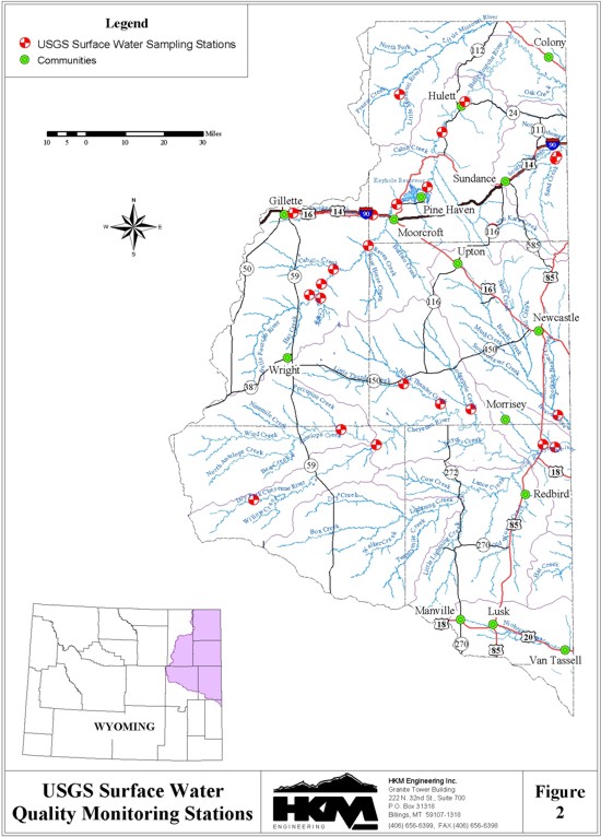
U.S. Geological Survey: Monitoring Program and Interest-Specific Studies
The U.S. Geological Survey (USGS) also has the data and analysis in place to provide a glimpse of water quality in the basin.
The USGS maintains 24 surface water-quality monitoring stations in the basin (Figure 2). In addition, the federal agency has compiled reports on areas of specific water quality-related study, all of which add to the picture of the basin.
U.S. Environmental Protection Agency: CBM Water Disposal Study
Region 8 of the EPA is currently updating its Best Available Technology (Economically Achievable) listing to include entries on coal bed methane produced waters. The agency has hired a contractor, the Eastern Research Group (ERG), to gather the technical and environmental data from sources in Wyoming. The study focuses on the Powder River and Raton basins for their production of waters that can be put to beneficial uses as they are discharged. The study considers zero discharge via reinjection, infiltration and evaporation, and beneficial use of the effluent in agriculture and wildlife water use, including reverse-osmosis processing. The information from the study will be used to establish baselines for NPDES permits in Indian reservations where the EPA still has primacy. In addition, the EPA hopes the guidelines will be used on a wide basis for permitting throughout states supporting CBM activity. According to EPA environmental engineer on region's NPDES team, the program had spent approximately $150,000 on the study by mid-December and was projected to produce a draft report in March and a final report in June of 2002 (EPA, 11 May 2001; Reed, 17 Dec. 2001).
CURRENT WATER QUALITY-RELATED ISSUES
Certain issues define the best chances to improve or enhance the water quality of this basin . or at least protect it. They are detailed here in industrial, agricultural, and municipal categories.
Industrial
The dominating theme is obviously coal bed methane and the water produced by each methane well. The development of the methane boom in the basin has already affected much of the basin's surface water and has the potential to affect all of the basin's surface waters within the low-lying areas.
Agricultural
Agriculture plays a large part in the surface water quality of the basin. The Wyoming Association of Conservation Districts realized this and has been creating and implementing Best Management Practices to improve water quality as part of its watershed planning efforts. Among the top issues are riparian-area stock activities, pesticide use, and issues stemming from concentrated animal feeding operations (CAFOs) and animal feeding operations (AFOs).
Municipal
In 1987, Congress amended the Clean Water Act to require the establishment of a comprehensive two- phased approach to control storm water discharges. The Phase I regulations were published in the Federal Register on November 16, 1990, and concentrate primarily on:
The Phase II Final Rule, published in the Federal Register on December 8, 1999, requires NPDES permit coverage for storm water discharges from:
Obviously, the Northeast Wyoming River Basins doesn't contain municipalities affected by the Phase I program, but small construction activities dot the area constantly, and municipalities are made wary by the open-ended nature of the applicability of Phase II.
Wastewater treatment plants have been covered under the NPDES permitting requirement since the Environmental Quality Act created W. S. 35-11-302.
COOPERATION
Cooperation among entities working with water quality is common. For instance, the DEQ surface water assessment teams have trained conservation district staff to perform water quality sampling so that the data they gather will have the same credibility as the state agency's.
The water quality picture could be improved though cooperation between DEQ and the State Engineer's Office water commissioners/hydrographers. Though SEO personnel have no official duties involved in water quality monitoring or enhancement, their work with irrigation and municipal diversions begs their involvement. This is not to say that commissioners need to be given additional tasks of sampling or enforcement, but that their "on-the-ground" knowledge of water quality and quantity developments could be of tremendous help to WQD staff and should be encouraged.
REFERENCES
Department of Environmental Quality, "Basin Summaries, 1998 Wyoming 305(b) Water Quality Assessment," web site: http://deq.state.wy.us/wqd/305b/wp305.htm accessed 18 Dec. 2001.
Department of Environmental Quality, Water Quality Division, Draft Source Water Protection Program, Jan. 2000.
Department of Environmental Quality, Water Quality Division, Draft Wyoming Nonpoint Source Management Plan Update, Dec. 1999.
Department of Environmental Quality, Environmental Quality Act of 1973, Chapter 11, web site: http://legisweb.state.wy.us/statutes/titles/title35/chapter11.htm accessed 19 Dec. 2001.
Department of Environmental Quality, Water Quality Division, Five-Year Comprehensive Monitoring Plan, Watershed Program, June 1998.
Department of Environmental Quality, Water Quality Division, Current Edition, Wyoming Water Quality Rules and Regulations, Chapters 1-22.
Department of Environmental Quality, "Wyoming's Program to Address Total Maximum Daily Loads," web site: http://deq.state.wy.us/wqd/watershed/tmdlinfo.htm accessed 7 Dec. 2001.
Department of Environmental Quality, Water Quality Division, Wyoming Wellhead Protection Program, June 1998.
Department of Environmental Quality, Wyoming's 2000 305(b) State Water Quality Assessment Report, web site: http://deq.state.wy.us/wqd/watershed/01452-doc.pdf June 2000.
Eisenhauer, Jim, DEQ WQD senior analyst, telephone interview, 13 Dec. 2001.
Environmental Protection Agency, "May 11, 2001 Kick-Off Letter LT051101.pdf," (coal bed methane produced water BAT establishment program) web site: http://www.epa.gov/Region8/water/wastewater/cbm/LT051101.pdf accessed 19 Dec. 2001.
Galloway, Christine, Crook County Conservation District district manager, telephone interview, 4 Dec. 2001.
Gianakos, Laura, DEQ/WQD environmental analyst, telephone interview, 18 Dec. 2001.
Reed, Mike, EPA environmental engineer on NPDES Team, Region 8, telephone interview, 17 Dec. 2001.
Shaw, Lisa, Niobrara County Natural Resources Conservation Service program director, telephone interview, 19 Nov. 2001.
University of Wyoming, Water Resources Center and Wyoming State Geological Survey, Ground Water Vulnerability Assessment: SDVC Report 98-01, Vols. I and II, 1998.
Zumberger, Jeremy, DEQ/WQD senior analyst; and Eisenhauer, Jim, DEQ/WQD senior analyst, personal interview, 7 Dec. 2001.
APPENDIX A: WATER QUALITY CHARACTERIZATION
The basic water quality picture in the Northeast Wyoming River Basins comes best and easiest from the DEQ through the discussions that accompany its Wyoming's 2000 305(b) State Water Quality Assessment Report. The comments are based on the Hydrologic Unit Codes (HUCs) that define the basin in drainages. (See figure below.)
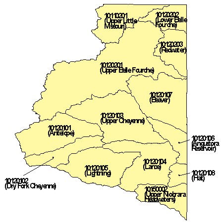
Excerpts of that text follow:
10120201 (Upper Belle Fourche)
A portion of the northeast area of [this hydrologic unit] lies within the Black Hills National Forest. Chapter 1 Wyoming Water Quality Rules and Regulations defines all surface waters within a National Forest as Class 2, with some exceptions. Non-perennial National Forest reach miles are protected by the state as Class 2 waters. The approximately 69 perennial reach miles within the forest are reported as fully supporting all designated beneficial uses. Land uses in the upper portion of the Belle Fourche drainage in include coal mining, oil and gas development and grazing together with historic uranium exploration. Acid mine drainage is typically not a problem in this area because naturally alkaline environmental conditions tend to neutralize any acidity which might be produced by mining. Additional land uses in other parts of this waterbody are irrigated agriculture (mostly hay production), ranching, uranium and coal mining. Stream flow data show that the Belle Fourche River from its headwaters in the southern part of the waterbody to below Rattlesnake Creek near Piney, Wyoming is non-perennial and flows naturally only in response to snowmelt or storm events. In this area, the stream channel is reported to cut through shale, sandstone, clinker and coal; the channel bottom itself is covered with silt and clay. Soils near the channel area are easily eroded clay loams with a low permeability. The most recent reported Belle Fourche headwaters area water quality data were collected in the 1980s from stations which have since been discontinued. More recent data which could be used for an assessment of this area are not available at this time. The approximately 125 perennial reach miles are reported as unassessed. The WG&F Basin Plan and other sources discuss the generally arid climate and unpredictable flow regime of the Belle Fourche watershed. Low or no flows followed by snow melt or seasonal storms tend to cause heavy sediment flushes in tributaries and the main stem. Keyhole Reservoir, northeast of Moorcroft in the middle portion of the waterbody, was completed in 1952 and allocation of its waters is subject to the Belle Fourche Compact between Wyoming and South Dakota. Historic and current monitoring data show total phosphate levels that may be of concern in the water entering Keyhole Reservoir. This phosphate tends to correlate with suspended sediment concentrations and is generally accepted as originating in the watershed's geologic materials. USEPA 1998 305(b) Guidelines state that waterbodies not meeting their designated beneficial uses (for example; fishing, aquatic life) due to naturally occurring conditions (conditions not caused by or related to past or present human activity) or catastrophic conditions are not to be reported as water quality limited. The Upper Belle Fourche River is in the WQD Proposed Comprehensive Five Year Monitoring Plan. In addition, coal bed methane development in the western part of this basin has been rapid and is increasing.10120202 (Lower Belle Fourche)Donkey Creek drainage - Gillette is the fourth largest community in Wyoming and lies at the upper end of the Donkey Creek drainage. None of the Donkey Creek tributaries is perennial. Donkey Creek itself becomes perennial a short distance west of Gillette. Historic evaluations list concerns about pathogens, siltation and loss of vegetative cover in the Stonepile Creek-Donkey Creek drainages. Recent information shows infrequent exceedance of man-caused pathogen limits. Stonepile Creek may appear to be perennial because of input from a point source. Three large coal fired power plants and a coal mine operate east of Gillette along Donkey Creek. Available downstream monitoring data for this area show some impacts which may be natural and due to geologic and soil materials; however, the amount of influence from man-caused activities upstream cannot be determined with available information. Approximately 67 perennial reach miles in this drainage are assessed as fully supporting but threatened for ALUS. Reservoirs in the lower end of the basin appear to function as a sediment trap for material transported from both the upper Belle Fourche and the Donkey Creek drainages.
.lies within the Black Hills area. The Belle Fourche River flows into South Dakota from this waterbody. Timbering, ranching, recreation and bentonite mining are the primary land uses. Bentonite outcrops in the bluffs and cliffs created by the river and is a historic natural component of waterbody sediment transport. USEPA 1998 305(b) Guidelines state that waterbodies not meeting their designated beneficial uses (for example; fishing, aquatic life) due to naturally occurring conditions (conditions not caused by or related to past or present human activity) or catastrophic conditions are not to be reported as water quality limited. The community of Colony in the northeastern corner of the state is the location of bentonite mining and processing facilities. Approximately 1,500 acres of abandoned bentonite mine lands on both sides of the Belle Fourche River in the Colony area have been reclaimed by AML. Many of the reclaimed sites were in direct contact with the Belle Fourche River. Although reclamation was designed to mitigate mined land sediment contribution to the Belle Fourche and its tributaries, the steep slopes and geologic materials were naturally unstable before they were mined. A 500 year flood event in 1991 removed some drainage channel features constructed during reclamation. These were repaired in 1992. In addition, private reclamation required by mining permits has resulted in vastly improved, stable grassland landscapes revegetated with native grasses. Data which could be used for an assessment are not available at this time. This waterbody is reported as unassessed for 1998. The Lower Belle Fourche is in the WQD Proposed Comprehensive Five Year Monitoring Plan.10120203 (Redwater)
.lies within the Black Hills area. Approximately 2 percent (or 41) of the total waterbody reach miles are perennial. A portion of the Black Hills National Forest is at the eastern edge of the waterbody and includes a few headwaters reach miles. Chapter 1 Wyoming Water Quality Rules and Regulations defines all surface waters within a National Forest as Class 2, with some exceptions. Non-perennial National Forest reach miles are protected by the state as Class 2 waters. The approximately 8 National Forest perennial reach miles are reported as fully supporting all designated beneficial uses. Timbering, recreation, irrigated agriculture (mainly hay) and livestock production are the primary land uses. According to the WG&F Belle Fourche Basin Plan, perennial reaches in this waterbody which contain self-sustaining wild trout populations are in Sand Creek (tributary to Redwater Creek) and its tributaries Spottedtail Creek and Cold Springs Creek; and Ogden Creek, tributary to Redwater Creek. Although Sand Creek and Redwater Creek are reported to be non-perennial in their upper headwaters, spring fed perennial flows occur slightly lower in the drainage. Sand Creek is rated by WG&F as one of the best wild brown trout streams in the state. USDAFS has worked to maintain and improve the fishery for streams on its lands by protecting riparian habitats and constructing stream channel improvements. Previous evaluations list concerns with the water quality impact of land development in the Sundance Creek area as well as multiple intermittent impacts in the Sand Creek area. Existing data may indicate elevated fecal coliform levels during some months, but the relative contribution of human and ungulate use cannot be determined at this time. The approximately 13 perennial reach miles in the Sand Creek drainage are reported as fully supporting all designated beneficial uses. Sundance Creek is in the WQD Proposed Comprehensive Five Year Monitoring Plan.10120101 (Antelope)
The headwaters of [this hydrologic unit] are about ten miles east of Edgerton. Land uses are primarily ranching and mineral development (coal and oil). Coal mining occurs in the northeastern one-third of the watershed. Naturally occuring conditions (infrequent short duration intense rainfall, highly erodible geological parent materials) result in: occasional high turbidity streamflow primarily during snowmelt and after rainfall, intermittent standing water and eventual sediment deposition. Some coal mines within this watershed have had Notices of Violation written for sediment control issues. Data which could be used for an assessment of perennial reach miles are not available at this time, and they are reported as unassessed for 1998. Antelope Creek is in the WQD Proposed Comprehensive Five Year Monitoring Plan.10120102 (Dry Fork of the Cheyenne)
Land uses in [this hydrologic unit] are primarily agricultural (dominated by ranching) and oil and gas development. Uranium exploration and mining occurred from the 1950s through the 1980s in the southern portion of this waterbody, an area where all reaches are non-perennial. Soils developed in the fine grained sandstone, calcareous shale and siltstone geologic materials and semi-arid climate tend to be alkaline, easily eroded and difficult to stabilize after being disturbed. The bed of the Dry Fork is reported to be composed of silt, sand and clay. Naturally occuring conditions (infrequent short duration intense rainfall, highly erodible geological parent materials) result in: occasional high turbidity streamflow primarily during snowmelt and after rainfall, intermittent standing water and sediment deposition. The WG&F basin plan and older monitoring data do not identify any impacts associated with the non-perennial reaches in this watershed. Based upon these sources and continuity of land use, perennial reach miles are reported as fully supporting all designated beneficial uses. Dry Fork is in the WQD Proposed Comprehensive Five Year Monitoring Plan.10120103 (Upper Cheyenne)
Coal mining occurs in [this hydrologic unit] directly east of Wright. Other land uses include oil and gas development and agriculture (primarily ranching with some crop and hay production). Naturally occuring conditions (infrequent short duration intense rainfall, highly erodible geological parent materials) result in: occasional high turbidity streamflow primarily during snowmelt and after rainfall, intermittent standing water and sediment deposition. Some coal mines within this watershed have had Notices of Violation written for sediment control issues. Old, sporadic monitoring data indicate that beryllium, copper, mercury and aluminum may be concerns within the watershed. Recent monitoring data are not available, and with the existing data it is not possible to determine what impacts are due to natural causes. USEPA 1998 305(b) Guidelines state that waterbodies not meeting their designated beneficial uses (for example; fishing, aquatic life) due to naturally occurring conditions (conditions not caused by or related to past or present human activity) or catastrophic conditions are not to be reported as water quality limited. This waterbody is reported as unassessed for 1998. The Upper Cheyenne River is in the WQD Proposed Comprehensive Five Year Monitoring Plan.10120104 (Lance Creek)
Land uses in [this hydrologic unit] are chiefly agricultural, with some oil and gas development. Naturally occurring conditions (infrequent short duration intense rainfall, highly erodible geological parent materials) result in: occasional high turbidity streamflow primarily during snowmelt and after rainfall, intermittent standing water and eventual sediment deposition. USEPA 1998 305(b) Guidelines state that waterbodies not meeting their designated beneficial uses (for example; fishing, aquatic life) due to naturally occurring conditions (conditions not caused by or related to past or present human activity) or catastrophic conditions are not to be reported as water quality limited. Based on land use and previous evaluations, approximately 40 miles of Lance Creek are assessed as partially supporting for ALUS. With existing data, it is not possible to determine how much of this impact is due to natural causes. Data which could be used to assess the remaining perennial waters in this watershed are not available at this time. Lance Creek is in the WQD Proposed Comprehensive Five Year Monitoring Plan.10120105 (Lightning Creek)
Land uses in [this hydrologic unit] are chiefly agricultural, with some oil and gas development. Nearly all reach miles in this watershed are non-perennial. Naturally occuring conditions (infrequent short duration intense rainfall, highly erodible geological parent materials) result in: occasional high turbidity streamflow primarily during snowmelt and after rainfall, intermittent standing water and eventual sediment deposition. USEPA 1998 305(b) Guidelines state that waterbodies not meeting their designated beneficial uses (for example; fishing, aquatic life) due to naturally occurring conditions (conditions not caused by or related to past or present human activity) or catastrophic conditions are not to be reported as water quality limited. Data which could be used to assess the perennial reach miles are not available at this time, and they are reported as unassessed for 1998. Lightning Creek is in the WQD Proposed Comprehensive Five Year Monitoring Plan.10120106 (Angustora Reservoir)
Land uses in [this hydrologic unit] are chiefly agricultural, with some oil and gas development. All of the other waterbodies in this basin drain into the Cheyenne River at the upper boundaries of this watershed. Naturally occuring conditions (infrequent short duration intense rainfall, highly erodible geological parent materials) result in: occasional high turbidity streamflow primarily during snowmelt and after rainfall, intermittent standing water and eventual sediment deposition. Previous evaluations indicate concerns with siltation, pesticides, turbidity, salinity, organics, pH and inorganics from agricultural or road sources on the Cheyenne River. The relative contribution of source watersheds to impacts within this watershed is not known. A sand and gravel operation has existed in the Cheyenne River riverbed in this waterbody since 1980. The operation supplies materials for road construction and other activities. The most recent reported suspended sediment/turbidity and other related measurements were taken at the downstream USGS gaging station (below the sand and gravel operation) in the 1981-82 water year. This station was discontinued in 1992. No monitoring data from other sources are available at this time. The approximately 20 perennial reach miles of the Cheyenne River within the waterbody have been evaluated as partially supporting ALUS. The balance of the perennial reach miles are reported as unassessed. The Lower Cheyenne River is in the WQD Proposed Comprehensive Five Year Monitoring Plan.10120107 (Beaver Creek)
Land uses in [this hydrologic unit] are chiefly agricultural, with some oil and gas development. Perennial reaches are located primarily along Beaver Creek and Stockade Beaver Creek. Naturally occurring conditions (infrequent short duration intense rainfall, highly erodible geological parent materials) result in: occasional high turbidity streamflow primarily during snowmelt and after rainfall, intermittent standing water and eventual sediment deposition. USEPA 1998 305(b) Guidelines state that waterbodies not meeting their designated beneficial uses (for example; fishing, aquatic life) due to naturally occurring conditions (conditions not caused by or related to past or present human activity) or catastrophic conditions are not to be reported as water quality limited. Previous evaluations indicated concerns with siltation and salinity from agricultural or road sources on lower Beaver Creek and Stockade Beaver Creek. Most of the irrigated agriculture within the watershed is in this area. Data which could be used for an assessment are not available at this time, and the perennial reach miles in this waterbody are reported as unassessed for 1998. Beaver Creek is in the WQD Proposed Comprehensive Five Year Monitoring Plan.10120108 (Hat Creek)
Land uses in [this hydrologic unit] are chiefly agricultural. Naturally occurring conditions (infrequent short duration intense rainfall, highly erodible geological parent materials) result in: occasional high turbidity streamflow primarily during snowmelt and after rainfall, intermittent standing water and eventual sediment deposition. USEPA 1998 305(b) Guidelines state that waterbodies not meeting their designated beneficial uses (for example; fishing, aquatic life) due to naturally occurring conditions (conditions not caused by or related to past or present human activity) or catastrophic conditions are not to be reported as water quality limited. Data which could be used for an assessment are not available at this time. Perennial reach miles in this waterbody are reported as unassessed for 1998. Indian Creek is in the WQD Proposed Comprehensive Five Year Monitoring Plan.10110201 (Upper Little Missouri)
Land uses in [this hydrologic unit] are mainly agriculture (both dryland and irrigated) and bentonite mining. Bentonite mining occurs primarily on the north side of the watershed, north of the Little Missouri River. Past evaluations for the Little Missouri and the North Fork indicated concerns about siltation resulting from both of these land uses. However, soils in this waterbody tend to be very difficult to stabilize after they are disturbed, and the naturally occurring exposed bentonite deposits are a historic component of waterbody sediment transport. USEPA 1998 305(b) Guidelines state that waterbodies not meeting their designated beneficial uses (for example; fishing, aquatic life) due to naturally occurring conditions (conditions not caused by or related to past or present human activity) or catastrophic conditions are not to be reported as water quality limited. Approximately 500 acres of abandoned bentonite mine lands on the northwest side of the Little Missouri River have been reclaimed by AML. Private bentonite mine companies continue to mine and reclaim land in this area. Bentonite mine land reclamation reduces the amount of sediment transported into the Little Missouri River main stem. No monitoring or evaluation data are available at this time which can be used to determine the number and proportion of reach miles impacted by siltation from mining, non-point source agricultural land uses and/or natural causes. A fish kill resulting from an oil spill on Good Lad Creek (tributary to the Little Missouri below Oshoto Reservoir) was reported in 1990. There have been no discharges to the creek since, and the fishery is evaluated by WG&F as being in normal condition. The approximately 5 perennial reach miles in this drainage are reported as fully supporting all designated beneficial uses. Perennial reach miles in the remainder of the waterbody are reported as unassessed for 1998. The Little Missouri River is in the WQD Proposed Comprehensive Five Year Monitoring Plan.10150002 (Upper Niobrara Headwaters)
Land use in [this hydrologic unit] is primarily agricultural, including grazing and dryland and center pivot irrigated crop production (mainly hay). Very few stream miles are perennial. Naturally occurring conditions (sandy loam soils, infrequent intense rainfall) result in: sediment transport during and after precipitation events, mostly intermittent stream flows after snowmelt or major rainfall, and sediment deposition. USEPA 1998 305(b) Guidelines state that waterbodies not meeting their designated beneficial uses (for example; fishing, aquatic life support) due to naturally occurring conditions (conditions not caused by or related to past or present human activity) or catastrophic conditions are not to be reported as water quality limited. Old evaluations list some concerns with sediment and its impact on fisheries. However, a Niobrara Basin Plan developed in 1996 by WG&F found only about 4 miles of shallow perennial streams which could support fish, mostly native, warm water non-game species. Perennial reach miles in this waterbody are evaluated as fully supporting all designated beneficial uses. The Niobrara River is in the WQD Proposed Comprehensive Five Year Monitoring Plan.
APPENDIX B
WATER QUALITY PROGRAMS
The following table is intended to provide a synopsis of water-quality programs in operating in the Northeast Wyoming River Basins. For more in-depth examination of some of the programs, see the main body of this memo.
| Water Quality Programs | ||||
| Program | Implementing Agency |
Authority | Type | Program Description |
| NPDES | DEQ/WQD | EQA Article 3 Chapter 2, 4, 7, 10, 18 |
SW PS |
Any discharge to surface waters of the state requires a permit to discharge. Each permitted discharge must meet effluent limitations within the TMDL allocations and maintain the use of the receiving water body. There are currently 70 NPDES permits in the study area that are classified as not being a storm water permit. There are several hundred storm water permits in the study area. Information on this program is available at http://deq.state.wy.us/wqd. |
| Permit to Construct | DEQ/WQD | EQA Article 3 Chapters 3, 5, 11, 12, 15, 20 | SW GW PS | Any public water supply system or any facility capable of causing or contributing to pollution is required to obtain a permit to construct prior to commencing construction. This program is directed at ensuring facilities are designed, constructed and operated to protect ground water and surface water resources. Chapter 5 requires certified operators for public water and sewage facilities. |
| Nonpoint Source Management and Control | DEQ/WQD | EQA Article 3, Section 319 of CWA |
SW GW NPS |
The state nonpoint source control program is a voluntary and incentive based program. The program seeks to control through education and encouragement of Best Management Practices, including demonstration, information and education, and restoration projects. Assessments and demonstration projects are selected for funding by the Wyoming Nonpoint Source Task force. The NPS Program manages Wyoming's allocations provided as grants by Section 319 and 205(j) of the Clean Water Act. Wetlands program uses a certification process to approve or deny federal permit actions concerning wetlands. Wetlands banking was established to expedite permitting. It allows industry, landowners, or others to build credits for the construction, restoration or enhancement of wetlands. These credits can be bought and sold as a means to expedite the mitigation of wetland impacts. The Nonpoint Source Management Plan is available at http://deq.state.wy.us/wqd. |
| Water Quality Assessments & Impaired Surface Water Bodies | DEQ/WQD | EQA Article 3, S. 305(b) & 303(d) of CWA |
SW GW NPS PS |
Section 305(b) of the Clean Water Act requires each state to assess and report on the quality of waters on a 2 year frequency. Section 303(d) requires each state every two years to list water bodies which are water quality impaired or threatened. This report and list are available at http://deq.state.wy.us/wqd/watershed/00902-doc.pdf. |
| Surface Water Monitoring | DEQ/WQD | EQA Article 3 |
SW PS NPS |
The WQD is progressing toward a more comprehensive monitoring and assessment program. In 1996, the Legislature passed a credible data law requiring the WQD to ensure all data used in listing impaired or threatened waters requiring scientifically valid data to be used. This credible data law has significantly increased monitoring of surface water in Wyoming. Monitoring efforts by WQD to comply with the credible data law are contained in the 305(b) report. |
| 404 Permit | US Army Corps of Engineers | Clean Water Act | SW PS NPS |
A permit is required from the Army Corps of Engineers to discharge dredge or fill material into navigable waters. |
| 401 Certifications | DEQ/WQD | EQA Article 3 |
SW PS NPS |
Any application for a Army Corps of Engineers 404 dredge and fill permit requires a certification from WQD that the dredge or fill will comply with all the requirements of Sections 301, 302, 303, 306 & 307 of the Clean Water Act. |
| Spill Program | DEQ/WQD | EQA Article 3 Chapter 4 |
SW GW PS |
Any person owning or having control over oil or a hazardous substance, which after release, enters or threatens to enter waters of the state shall take action to stop and contain the release, notify WQD, correct the cause, clean up the release and dispose of the waste in an acceptable manner. |
| Source Water Protection | DEQ/WQD | EQA Article 3 |
SW GW |
Wyoming has developed a voluntary source water protection program as required by each state under Section 1453 of the SDWA. Source water assessment involves four steps: delineate the area which contributes water to the well or surface water intake; inventory of potential sources of contamination; complete an analysis of the susceptibility of the well or intake to contamination from the previous inventory; and draft up a report summarizing the findings. |
| Wellhead Protection Program | DEQ/WQD | EQA Article 3 |
GW | Wyoming has developed and received approval from EPA endorsing its wellhead protection program developed pursuant to Section 1428 of the SDWA. The program is voluntary and allows public water supply systems to protect groundwater sources of supply. |
| Underground Injection Control Wells | DEQ/WQD DEQ/LQD OGCC |
EQA Article 3 Chapters 13 & 16 Article 4 W.S. 30-5-101 thru 305 |
PS GW |
Any person who construct, installs, or operates a Class I, IV, or V underground
injection control well must first obtain a permit from the DEQ/WQD. Class I wells are
deep injection wells that discharge into a Class VI groundwater formation and include
hazardous waste wells of which there are none in Wyoming. Commercial Class II
wells are regulated as a Class I well. Class IV wells inject hazardous waste into
shallow aquifers and are prohibited. Class V wells are wells other than the other 4
classifications, injecting into or above underground sources of drinking water such as
drain fields, air conditioning return wells, dry wells, etc. Any person injecting into a Class III well must obtain a permit or license from DEQ/WQD. A Class III well injects into or above a drinking water for the purpose of extracting minerals. The most common in situ mining wells in Wyoming are uranium and soda ash. Any person injecting into a noncommercial Class II well is required to obtain a permit from the Wyoming Oil and Gas Conservation Commission. Class II wells inject fluids which are brought to the surface in connection with natural gas storage operations or conventional oil and gas production, fluids for enhanced recovery of oil or natural gas and for storage of hydrocarbons. |
| State Pesticide Management Plan (SMP) | WY Dept. of Agriculture | W.S. 35-7-350 thru 374 | NPS SW GW |
The Department of Agriculture has developed a SMP directed at the protection of water resources from the application of pesticides. The SMP program has received EPA approval. |
| SMP GW Monitoring | WY Dept. of Agriculture | W.S. 35-7-350 thru 374 | GW | Utilizing pesticide registration fees and funding from 319 grants, the USGS has been contracted to conduct a statewide assessment of the contamination of groundwater caused by pesticides. Of the counties completed at the time of this report, no levels above drinking water maximum contaminant levels have been found. Monitoring results can be accessed at http://wy.water.usgs.gov/projects/tests/pesticides/.html |
| Mines | DEQ/LQD | EQA Article 4 |
PS NPS SW GW |
License or permits are required for any mining operation or operation by which solid minerals are intended to be extracted from the earth. This includes surface and underground mining. The extraction of sand, gravel, dirt, scoria, limestone, dolomite, shale, ballast, or feldspar by a landowner for noncommercial use does not require a permit nor does an area of less than 10 surface acres under certain conditions. |
| Abandoned Mines | DEQ/AML | Article 12 | PS NPS SW GW |
The abandoned mines program accomplishes reclamation of eligible properties adversely affected by mining prior to August 3, 1977. Eligible Public facilities and utilities adversely affected by mining prior to August 3, 1977 and the construction of new public facilities or utilities in communities impacted by coal or mineral mining and processing practices. |
| Landfills & Hazardous Wastes Superfund Sites |
DEQ/SHWD USEPA | EQA Article 5 CERCLA | PS SW GW |
No person, except when authorized by a SHWD permit, shall locate, construct, operate
or close a solid waste management facility or modify the design, construction or
operation of a solid waste management facility. The SHWD has primacy of the federal
RCRA program regulating hazardous waste generators and transporters, hazardous
waste treatment, storage and disposal facility operators, and hazardous waste
corrective actions. EPA regulates superfund sites in Wyoming. |
| Well Construction & Abandonment | WY State Engineer (SEO) | SEO Regulations | PS GW |
The state engineer has regulations requiring adequate design, construction and abandonment of wells to protect groundwater resources. |
| Wellhead Protection Program | DEQ/WQD | EQA Article 3 |
GW | Wyoming has developed and received approval from EPA endorsing its wellhead protection program developed pursuant to Section 1428 of the SDWA. The program is voluntary and allows public water supply systems to protect groundwater sources of supply. |
| Underground Storage Tanks | DEQ/WQD | EQA Article 14 |
PS SW GW |
Wyoming has primacy of the federal RCRA program regulating underground storage tanks (UST). This program regulates the design, construction and operation of USTs and provides financial responsibility for UST and commercial above ground storage tank owner/operators. In addition, a cleanup fund exists to remediate contamination caused by leaking USTs. |
| Watershed Planning | Wyoming Association of Conservation Districts | Clean Water Act | SW | Districts throughout the state have had an interest in providing watershed planning in lieu of the imposition of TMDLs in the interest of imposing local control in place of federal action. Their actions range from the establishment of baseline water quality data to creation and implementation of Best Management Practices to improve water quality and ongoing monitoring. |
| Coal Bed Methane Water Disposal Study | EPA | SW | The federal agency is performing an economic analysis to assess disposal options for CBM produced water. This will help establish the Best Available Technology (Economically Achievable) that will guide NPDES permits where the EPA still has primacy. It also has the capacity to be applied more generally wherever CBM-related NPDES permits are required (like in Wyoming). | |