Wyoming State Water Plan
Wyoming State Water Plan
Wyoming Water Development Office
6920 Yellowtail Rd
Cheyenne, WY 82002
Phone: 307-777-7626

Wyoming Water Development Office
6920 Yellowtail Rd
Cheyenne, WY 82002
Phone: 307-777-7626


| SUBJECT: |
Appendix J Storage Operation and Description SPENCER |
| PREPARED BY: | HKM Engineering Inc. |
| DATE: | March 2002 |
KEY STORAGE FACILITIES
| Reservoir: | SPENCER (or LAK, ENL OF 1890R & 4917R) | ||||||||||||||||||||||||||||||||||||||||||||||||||||
| Date: | 12 Feb. 2001 | ||||||||||||||||||||||||||||||||||||||||||||||||||||
| Location: | SWNE 6,T44N,R60W | ||||||||||||||||||||||||||||||||||||||||||||||||||||
| Owner: | TRUE RANCHES, INC. | ||||||||||||||||||||||||||||||||||||||||||||||||||||
| Year of Construction: | 1910 |  | |||||||||||||||||||||||||||||||||||||||||||||||||||
| Enlargement History: | 1940, 1953 | ||||||||||||||||||||||||||||||||||||||||||||||||||||
| Total Storage: | 2,847 acre-feet | ||||||||||||||||||||||||||||||||||||||||||||||||||||
| Active Storage: | 2,162 acre-feet | ||||||||||||||||||||||||||||||||||||||||||||||||||||
| Dead Storage: | Data not available | ||||||||||||||||||||||||||||||||||||||||||||||||||||
| Area/Capacity Data: | (Source: Feb. 1941 "Map to Accompany Application for Enlargement of Spencer Reservoir," The Ohio Company, applicant, on file in SEO Safety of Dams office.) | ||||||||||||||||||||||||||||||||||||||||||||||||||||
| |||||||||||||||||||||||||||||||||||||||||||||||||||||
| Dam Construction Type: | Earth Fill | ||||||||||||||||||||||||||||||||||||||||||||||||||||
| Outlet: | Two 18" x ¼" welded steel pipes, asphalt coated, "placed on six- inch centers," (permit). This could mean the pipes were placed with their walls six inches apart. | ||||||||||||||||||||||||||||||||||||||||||||||||||||
| Spillway: | 100 x 5-foot, rock-lined channel cut in the crest of the dam | ||||||||||||||||||||||||||||||||||||||||||||||||||||
| End-of-Month Storage Records: | No | ||||||||||||||||||||||||||||||||||||||||||||||||||||
| Water Rights: | (Source: Tabulation of Adjudicated Surface Water Rights of the State of Wyoming, Water Division Number Two, Oct. 1999) | ||||||||||||||||||||||||||||||||||||||||||||||||||||
| |||||||||||||||||||||||||||||||||||||||||||||||||||||
| Designated Use: | Irrigation | ||||||||||||||||||||||||||||||||||||||||||||||||||||
| Associated Irrigation Diversions: | Information not available. | ||||||||||||||||||||||||||||||||||||||||||||||||||||
| Associated Irrigation Diversions: | (Source: Tabulation of Adjudicated Surface Water Rights of the State of Wyoming, Water Division Number Two, Oct. 1999) | ||||||||||||||||||||||||||||||||||||||||||||||||||||
| |||||||||||||||||||||||||||||||||||||||||||||||||||||
| References: | Map to Accompany Application for Enlargement of Spencer Reservoir, the Ohio Company, Newcastle, Wyoming, 3 Feb. 1941. | ||||||||||||||||||||||||||||||||||||||||||||||||||||
| Tabulation of Adjudicated Surface Water Rights of the State of Wyoming, Water Division Two, Oct. 1999. | |||||||||||||||||||||||||||||||||||||||||||||||||||||
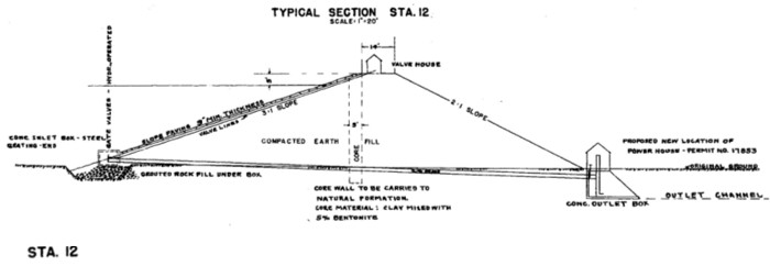
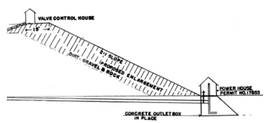
Spencer Dam cross sections ("Map to Accompany Application for Enlargement of Spencer Reservoir", the Ohio Company, Newcastle, Wyoming, 3 Feb. 1941):
Net evaporative loss for Spencer Reservoir:
| Lewis Annual Evaporation | 40 |
| Total Storage | 2,847 |
| Jan | Feb | Mar | Apr | May | Jun | Jul | Aug | Sep | Oct | Nov | Dec | ||
| Average percent of storage | 54.3 | 58.0 | 66.5 | 69.8 | 76.5 | 78.1 | 76.6 | 74.4 | 72.2 | 53.8 | 53.5 | 53.7 | |
| Generated storage (acre-feet) | 1546 | 1653 | 1894 | 1988 | 2177 | 2222 | 2182 | 2117 | 2056 | 1531 | 1523 | 1528 | |
| Corresponding area (acres) | 103.2 | 105.2 | 109.8 | 111.5 | 115.1 | 115.9 | 115.1 | 113.9 | 112.8 | 102.9 | 102.8 | 102.9 | |
| Calculations: | |||||||||||||
| Monthly Lewis Evap. (inches) | 1.08 | 1 | 1.56 | 3.2 | 4.6 | 5.24 | 6.84 | 6.24 | 4.6 | 3.04 | 1.56 | 1.04 | |
| Monthly Precipitation (inches) | 0.25 | 0.75 | 0.75 | 1.75 | 2.75 | 2.75 | 1.75 | 1.75 | 1.25 | 0.75 | 0.75 | 0.75 | |
| Net Evaporation (inches) | 0.83 | 0.25 | 0.81 | 1.45 | 1.85 | 2.49 | 5.09 | 4.49 | 3.35 | 2.29 | 0.81 | 0.29 | TOTAL |
| Total Net Evaporation (acre-feet) | 7 | 2 | 7 | 13 | 18 | 24 | 49 | 43 | 31 | 20 | 7 | 2 | 224 |