Wyoming State Water Plan
Wyoming State Water Plan
Wyoming Water Development Office
6920 Yellowtail Rd
Cheyenne, WY 82002
Phone: 307-777-7626

Wyoming Water Development Office
6920 Yellowtail Rd
Cheyenne, WY 82002
Phone: 307-777-7626


| SUBJECT: |
Appendix J Storage Operation and Description |
| PREPARED BY: | HKM Engineering Inc. |
| DATE: | March 2002 |
INTRODUCTION
In accordance with the scope of services, an inventory of the storage facilities located within the Northeast Wyoming River Basins was completed. This inventory is intended to be used for future planning and to provide information for water availability modeling of the basins. After consulting with State Engineer's Office personnel, HKM composed technical reports on six reservoirs considered significant. In addition, HKM developed summaries for 209 reservoirs detailing their tributaries, capacities, locations, and corresponding evaporative rates per year. These data comprise an effective backbone for the modeling work to follow.
Because reservoir operations are changing rapidly in the Northeast Wyoming River Basins, the storage operations memorandum will probably demand updating more than most other elements of the plan. For example, in mid-October, 2001, Phillips Petroleum proposed two reservoirs with a combined capacity of more than 810 acre-feet on a tributary of the Cheyenne River. This departs from the smaller impoundments used by most coal bed methane operations (more closely resembling stock ponds) and could represent the beginning of a change in the hydrology of the Cheyenne. As of this report's completion at the end of 2001, "Bell 1" and "Bell 2" reservoirs remain proposals only, but their significance could become apparent in the next few years and require further investigation.
STORAGE FACILITIES SELECTION
The initial selection of storage to be inventoried was based on a review of the Safety of Dams Active Dams database. As per requests from the State Engineer's Office and Wyoming Water Development Commission personnel, all surface water storage in structures containing more than 50 acre-feet of storage or more than 20 feet high (meeting the minimum standards for inclusion in the Dam Safety database) were selected. These selection criteria produced a set of 209 surface water storage facilities. The statistics for each of these reservoirs are presented in the summary tables provided following the six detailed reports.
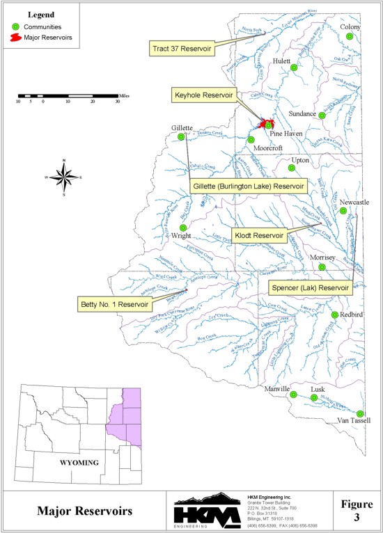
State Engineer's Office Water Division Two commissioners agreed that a further set of criteria should be introduced to provide a list from which the dams of particular significance to the basin could be developed. Commissioners agreed that a limit of 1,000 acre-feet capacity and "serving multiple users" produced a list of reservoirs significant to the basin, reducing the secondary selection list to six.
METHODOLOGY
Base Data
The information provided in the six in-depth reports and the 209 summaries that follow comes primarily from the State Engineer's Office's (SEO) Safety of Dams Active Dams database. This is also the primary reference tool for SEO personnel inspecting dam safety around the state. Some data are not available in that database. Associated water right information had to be culled from the SEO Tab Books in Water Divisions I and II. Operational details were gleaned from interviews. Area-capacity tables, illustrations, and pictures often came from SEO Water Div. II files or Safety of Dams office records.
Unfortunately, these sources do not agree on all points. It is not within the scope of this study to resolve conflicts. As much information as possible was provided for each of the six significant reservoirs. In general, when the source is other than the Safety of Dams Active Dams database, the source is noted.
Finally, data in this memorandum are presented as they are found in the original sources. Terminology, references, and notes are unchanged.
The following definitions provided by the U.S. Bureau of Reclamation provide a brief definition of key terms:
Active capacity. The reservoir capacity normally usable for storage and regulation of reservoir inflows to meet established reservoir operating requirements. It extends from the highest of either the top of exclusive flood control capacity, the top of joint use capacity, or the top of active conservation capacity, to the top of inactive capacity. It is also the total capacity less the sum of the inactive and dead capacities. The reservoir capacity that can be used for irrigation, power, municipal and industrial use, fish and wildlife, recreation, water quality, and other purposes.Data Gathering for Storage Evaporative LossesNormal water surface. The highest elevation at which water is normally stored, or that elevation which the reservoir should be operated for conservation purposes. Usually the elevation at the top of the active conservation capacity. The maximum elevation to which the reservoir may rise under normal operating conditions exclusive of flood control capacity.
Total capacity. The reservoir capacity below the highest of the elevations representing either the top of exclusive flood control capacity, the top of joint use capacity, or the top of active conservation capacity. In the case of a natural lake which has been enlarged, the total capacity includes the dead capacity of the lake. Total capacity is used to express the total quantity of water which can be impounded and is exclusive of surcharge capacity.
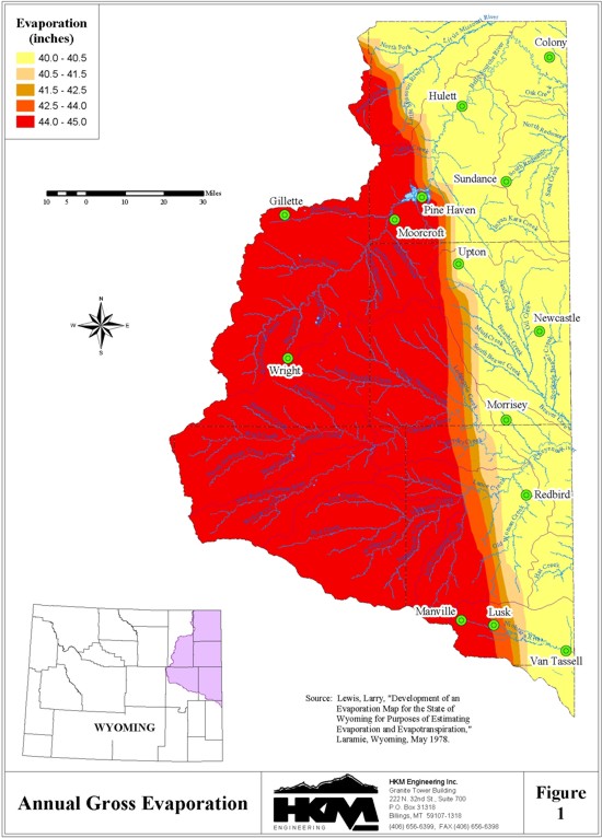
To understand how much water is lost to reservoir evaporation throughout the basin, it was necessary to correlate the reservoir locations in the State Engineer's Office Tabulation of Adjudicated Surface Waters for Divisions one and two (where applicable) and the Safety of Dams Active Dams database with values from the Annual Lake Evaporation Map in Larry E. Lewis' Development of an Evaporation Map for the State of Wyoming for Purposes of Estimating Evaporation and Evapotranspiration. This cross-correlation produced an annual loss value (in inches of water). This was then multiplied by the factors in Lewis' Table VIII, "Pathfinder Dam Annual Evaporation Distribution" to produce monthly gross evaporation in inches. The values for the months of May-September were summed, and the result was multiplied by the factors in Table IX, "May Through September Monthly Evaporation Distribution." These calculations yielded the monthly values provided in the summary tables. Figure 1 illustrates the annual Lewis evaporation depths.
Though Lewis' work was completed in 1978, and the more recent NOAA Technical Report NWS: Evaporation Atlas for the Contiguous 48 United States would seem like a better choice for its 1983 vintage, Lewis' work contains far more data from Wyoming. Lewis also worked with approximately as much data as is available today to compile his maps, rejecting data points on field inspection, and still had a much larger data set and one of greater duration (20 years compared with 15) than the national study draws upon.
For more detailed information, water commissioners, Safety of Dams personnel, landowners, operators, and officials familiar with the reservoirs were consulted. The documentation accompanying permits or applications for enlargement yielded the most data.
Calculations for Gross Storage Evaporative Losses
Once the Lewis evaporation numbers were obtained (inches), they were multiplied with the water area (acres) exposed to the atmosphere in an average month. To do this, HKM collected the available end-of- month storage records for the significant reservoirs identified earlier. In the case of the Northeast Wyoming River Basins, records existed for Keyhole Reservoir. Keyhole's average end-of-month elevation was computed, then correlated with its area-capacity table to generate a corresponding end-of- month surface area in acres. Subsequent calculations can generate the gross evaporative loss in acre-feet per month:
LossGross(acre-ft)=Lewis(in.)xArea(acres)
                       12(in./ft)
Methodology . Calculation of Net Evaporative Losses in Storage
LossNet(acre-ft)=[Lewis(in.)-Precip(in.)]xArea(acres)
                             12(in./ft)
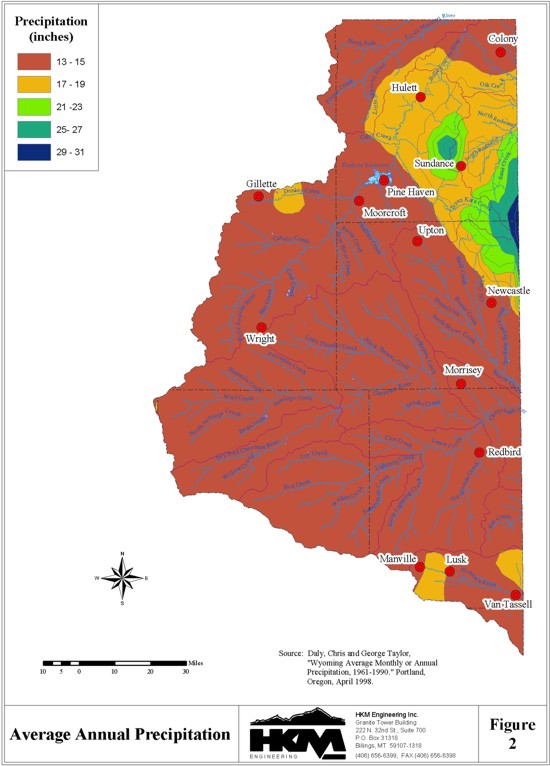
This study depends on the precipitation mapping completed by Oregon State University in its Parameter-
elevation Regressions on Independent Slopes Model (PRISM), which generated gridded estimates of
climate parameters from historical meteorological data collected 1961-1990. (See
http://www.ocs.orst.edu/prism/overview.html for more information.) Because the PRISM data are
available in a GIS format, the locations of the facilities were loaded into the same GIS to produce a
corresponding monthly precipitation estimate. Figure 2 illustrates the average annual precipitation depths
from PRISM.
Keyhole's net evaporative loss estimate is provided below the end-of-month storage summary attached to the overview of the facility.
Evaporative Losses from Storage for Remaining Facilities
HKM divided the active capacity for Keyhole by the end-of-month records to produce an end-of-month percentage of active capacity. Active rather than total capacity was used here because so much of Keyhole's total storage capacity is tied up in flood storage . something none of the other, smaller significant reservoirs in this basin are designed for. The end-of-month percentages were multiplied by each significant reservoir's capacity to provide an estimated end-of-month storage, which was correlated with available area-capacity tables for estimated end-of-month area. This number was used to calculate the gross and net evaporative losses as above, except that the sparseness of the area-capacity tables provided for this study forced use of linear interpolation to determine the area corresponding to a given level.
COMPACT ISSUES
Two interstate compacts govern the allocation of surface water in the Northeast Basin, the Belle Fourche Compact (with South Dakota) and the Upper Niobrara River Compact (with Nebraska). The Cheyenne River and Little Missouri River compacts were never ratified or completed.
First, the Belle Fourche River's surface storage compact constraints limit Wyoming to 10 percent of large storage facilities built after 1943.
By the Wyoming Water Planning Program Report No. 10, Water & Related Land Resources of
Northeastern Wyoming (pp. 51-52),
No reservoir built solely to use the water allocated to Wyoming shall have a
capacity in excess of 1,000 acre-feet.
The Belle Fourche River Compact provides a basis for the division of the waters
of the Belle Fourche River between Wyoming and South Dakota, and was
negotiated and ratified by these two states in 1943 and by the Federal
Government in 1944. The compact includes the following provisions:
The Upper Niobrara River Compact (1962) also puts constraints on surface water storage:
90 percent to South Dakota
10 percent to Wyoming
This article of the Upper Niobrara River Compact has never been acted on by either state, according to Deputy State Engineer Dick Stockdale.Article V
- Wyoming and Nebraska agree that the division of surface waters of the upper Niobrara River shall be in accordance with the following provisions:
- There shall be no restrictions on the use of the surface waters of the upper Niobrara River by Wyoming except as would be imposed under Wyoming law and the following limitations:
- No reservoir constructed after August 1, 1957, and used solely for domestic and stock water purposes shall exceed twenty (20) acre-feet in capacity.
- Storage reservoirs with priority dates after August 1, 1957, and storing water from the main stem of the Niobrara River east of range 62 west of the 6th p.m. and from the main stem of Van Tassel Creek south of section 27, township 32 north, range 60 west of the 6th p.m. shall not store in any water year (October 1 of one (1) year to September 30 of the next year) more than a total of five hundred (500) acre-feet of water.
- Storage in reservoirs with priority dates prior to August 1, 1957, and storing water from the main stem of the Niobrara River east of range 62 west and from the main stem of Van Tassel Creek south of section 27, township 32 north, shall be made only during the period October 1 of one (1) year to June 1 of the next year and at such times during the period June 1 to September 30 that the water is not required to meet the legal requirements by direct flow appropriations in Wyoming and Nebraska west of range 55 west. Where water is pumped from such storage reservoirs, the quantity of storage water pumped or otherwise diverted for irrigation purposes or other beneficial purposes from any such reservoir in any water year shall be limited to the capacity of such reservoir as shown by the records of the Wyoming state engineer's office, unless additional storage water becomes available during the period June 1 to September 30 after meeting the legal diversion requirements by direct flow appropriations in Wyoming and Nebraska west of range 55 west.
- Storage in reservoirs with priority dates after August 1, 1957 and storing water from the main stem of the Niobrara River east of range 62 west and the main stem of Van Tassel Creek south of section 27, township 32 north, shall be made only during the period October 1 of one (1) year to May 1 of the next year and at such times during the period May 1 and September 30 that the water is not required for direct diversion by ditches in Wyoming and in Nebraska west of range 55 west.
- Direct flow rights with priority dates after August 1, 1957, on the main stem of the Niobrara River east of range 62 west and Van Tassel Creek south of section 27, township 32 north, shall be regulated on a priority basis with Nebraska rights west of range 55 west, provided that any direct flow rights for maximum of one hundred forty-three (143) acres which may be granted by the Wyoming state engineer with a priority date not later than July 1, 1961 for lands which had territorial rights under the Van Tassel No. 4 Ditch with a priority date of April 8, 1882, and the Van Tassel No. 5 Ditch with a priority date of April 18, 1882, shall be exempt from the provisions of this subsection (E).
- All direct flow diversions from the main stem of the Niobrara River east of range 62 west and from Van Tassel Creek south of section 27, township 32 north shall at all times be limited to their diversion rates as specified by Wyoming law, and provided that Wyoming laws relating to diversion of "surplus water" (W.S. 41-4-317 through 41-4-324) shall apply only when the water flowing in the main channel of the Niobrara River west of range 55 west is in excess of the legal diversion requirements of Nebraska ditches having priority dates before August 1, 1957.
The significant reservoirs detailed in this memorandum are listed in the following table and displayed in Figure 3:
| Reservoir | Permit | Latitude | Longitude | Year Complete |
Active Capacity (af) |
Dam Height (ft) |
Surface Area (acres) |
Ann. Net Evap. Loss (af) |
|---|---|---|---|---|---|---|---|---|
| BETTY NO. 1 | 6322R | 43° 23' 40'' | 105° 28' 28'' | 1954 | 1,345 | 32 | 171 | 355 |
| GILLETTE | 1046R | 44° 17' 54'' | 105° 29' 24'' | 1908 | 2,080 | 10 | 145 | N.A. |
| KEYHOLE | 5707R | 44° 22' 54'' | 104° 46' 48'' | 1952 | 185,800 | 115 | 13,686 | 12,915 |
| KLODT | 2897R | 43° 46' 12'' | 104° 23' 18'' | 1920 | 980 | 26 | 124 | 317 |
| SPENCER | 5410R | 43° 49' 24'' | 104° 6' 34'' | 1910 | 2162 | 45 | 126 | 224 |
| TRACT 37 | 7610R | 44° 53' 15'' | 104° 50' 28'' | 1976 | 2454 | 31 | 302 | 560 |
REFERENCES
Active Dams, State Engineer's Office Safety of Dams Engineering Div. Database, transmitted by Larry Stockdale, Safety of Dams engineering consultant, 16 Feb. 2001.
Development of an Evaporation Map for the State of Wyoming for Purposes of Estimating Evaporation and Evapotranspiration, Larry Eugene Lewis, University of Wyoming master's thesis, Department of Civil and Architectural Engineering and the Graduate School, Laramie, Wyoming, May 1978.
NOAA Technical Report NWS 33: Evaporation Atlas for the Contiguous 48 United States, U.S. Department of Commerce, National Oceanic and Atmospheric Administration, national Weather Service, Washington, D.C., June 1982.
Richard Stockdale, deputy state engineer, telephone interview, 7 March 2001.
Tabulation of Adjudicated Surface Water Rights of the State of Wyoming, Water Division Number Two, Oct. 1999, database transmitted by Rebecca Mathisen, SEO Technical Services Division administrator, 8 Sept. 2000.
U.S. Bureau of Reclamation, "U.S. Bureau of Reclamation Glossary," Internet Site http://www.usbr.gov/cdams/glossary.html#N 14 Nov. 2001. [new link 10/2009 HERE]
Wyoming Water Atlas, Wyoming Water Development Commission and the University of Wyoming, University of Wyoming (Laramie, Wyoming), 1990.
Wyoming Water Planning: A Report for Updating the Process, Wyoming Water Development Commission & Wyoming State Engineer's Office, Cheyenne, Wyoming, 1996.
Wyoming Water Planning Program Report No. 10, Water & Related Land Resources of Northeastern Wyoming, Wyoming State Engineer's Office, Cheyenne, Wyoming, April 1972.