Wyoming State Water Plan
Wyoming State Water Plan
Wyoming Water Development Office
6920 Yellowtail Rd
Cheyenne, WY 82002
Phone: 307-777-7626

Wyoming Water Development Office
6920 Yellowtail Rd
Cheyenne, WY 82002
Phone: 307-777-7626


| SUBJECT: |
Appendix J Storage Operation and Description KLODT |
| PREPARED BY: | HKM Engineering Inc. |
| DATE: | March 2002 |
KEY STORAGE FACILITIES
| Reservoir: | KLODT | ||||||||||||||||||||||||
| Date: | 26 Feb. 2001 | ||||||||||||||||||||||||
| Location: | SWSE 23,T44N,R63W | ||||||||||||||||||||||||
| Owner: | BILL TOWNSEND | ||||||||||||||||||||||||
| Year of Construction: | 1920 | ||||||||||||||||||||||||
| Total Storage: | 1,708 acre-feet | ||||||||||||||||||||||||
| Active Storage: | 980 acre-feet | ||||||||||||||||||||||||
| Dead Storage: | None reported in permit. | ||||||||||||||||||||||||
| Area/Capacity Data: | (Source: April 1916 "Map to Accompany Application for Klodt Reseervoir," Joseph J. Klodt, applicant, on file in SEO Safety of Dams office.) | ||||||||||||||||||||||||
| |||||||||||||||||||||||||
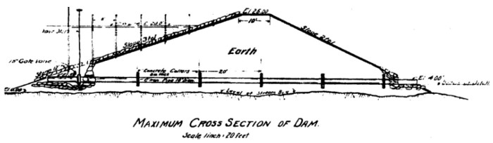
| Dam Construction Type: | Earth Fill | ||||||||||||||||||||||||
| Outlet: | 18-inch-diameter cast-iron pipe controlled by a gate valve at the upstream face of the dam | ||||||||||||||||||||||||
| Spillway: | 300 x 5 feet (at base) | ||||||||||||||||||||||||
| End-of-Month Storage Records: | No | ||||||||||||||||||||||||
| Water Rights: | (Source: Tabulation of Adjudicated Surface Water Rights of the State of Wyoming, Water Division Number Two, Oct. 1999) | ||||||||||||||||||||||||
| |||||||||||||||||||||||||
| Designated Use: | Irrigation | ||||||||||||||||||||||||
| Associated Irrigation Diversions: | Used in Beaver Valley (permit 13382) and Sunset ditches (13383) | ||||||||||||||||||||||||
| References: | Map to Accompany Application for Klodt Reservoir, Joseph J. Klodt, Newcastle, Wyoming, 3 April 1916. | ||||||||||||||||||||||||
Klodt Dam cross section (Source: "Map to Accompany Application for Klodt Reservoir," Joseph J. Klodt, Newcastle, Wyoming, 3 April 1916):
Net evaporative loss for Klodt Reservoir:
| Lewis Annual Evaporation (in.) | 40 |
| Total Storage (acre-feet) | 1,708 |
| Jan | Feb | Mar | Apr | May | Jun | Jul | Aug | Sep | Oct | Nov | Dec | ||
| Average percent of storage | 52.1 | 55.7 | 63.8 | 67.0 | 73.3 | 74.9 | 73.5 | 71.3 | 69.2 | 51.6 | 51.3 | 51.5 | |
| Generated storage (acre-feet) | 889 | 951 | 1090 | 1144 | 1253 | 1278 | 1255 | 1218 | 1183 | 881 | 876 | 879 | |
| Corresponding area (acres) | 116.4 | 121.5 | 133.2 | 137.7 | 146.9 | 149.0 | 147.1 | 144.0 | 141.0 | 115.7 | 115.3 | 115.5 | |
| Calculations: | |||||||||||||
| Monthly Lewis Evap. (inches) | 1.08 | 1 | 1.56 | 3.2 | 4.6 | 5.24 | 6.84 | 6.24 | 4.6 | 3.04 | 1.56 | 1.04 | |
| Monthly Precipitation (inches) | 0.25 | 0.25 | 0.75 | 1.25 | 2.25 | 2.25 | 1.75 | 1.25 | 1.25 | 0.75 | 0.25 | 0.25 | |
| Net Evaporation (inches) | 0.83 | 0.75 | 0.81 | 1.95 | 2.35 | 2.99 | 5.09 | 4.99 | 3.35 | 2.29 | 1.31 | 0.79 | TOTAL |
| Total Net Evaporation (acre-feet) | 8 | 8 | 9 | 22 | 29 | 37 | 62 | 60 | 39 | 22 | 13 | 8 | 317 |