Wyoming State Water Plan
Wyoming State Water Plan
Wyoming Water Development Office
6920 Yellowtail Rd
Cheyenne, WY 82002
Phone: 307-777-7626

Wyoming Water Development Office
6920 Yellowtail Rd
Cheyenne, WY 82002
Phone: 307-777-7626


| SUBJECT: |
Appendix J Storage Operation and Description GILLETTE |
| PREPARED BY: | HKM Engineering Inc. |
| DATE: | March 2002 |
KEY STORAGE FACILITIES
| Reservoir: | GILLETTE (or BURLINGTON LAKE/FISHING LAKE) | ||||||||||||||||||||||||
| Date: | 26 Feb. 2001 | ||||||||||||||||||||||||
| Location: | SWNE 22,T50N,R72W | ||||||||||||||||||||||||
| Owner: | City of Gillette Parks and Recreation Department | ||||||||||||||||||||||||
| Year of Construction: | 1908 |
 | |||||||||||||||||||||||
| Total Storage: | 2,680 acre-feet | ||||||||||||||||||||||||
| Active Storage: | 2,080 acre-feet Note: This is probably not accurate, given the lake's silting problems. | ||||||||||||||||||||||||
| Dead Storage: | 2080 acre-feet | ||||||||||||||||||||||||
| Area/Capacity Data: | (Source: "Proposed Ditch and Reservoir," by CB&Q Ry, Feb. 1907, on file in Safety of Dams office, SEO, Cheyenne, Wyoming.) | ||||||||||||||||||||||||
| |||||||||||||||||||||||||
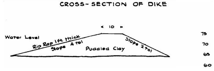
| Dam Construction Type: | Earth Fill | ||||||||||||||||||||||||
| Outlet: | No operational outlet | ||||||||||||||||||||||||
| Spillway: | Principal spillway: Twelve-inch corrugated metal pipe | ||||||||||||||||||||||||
| Auxiliary: Once the flow capacity for the outlet has been exceeded, the lake spills over the roadway over the outlet pipe. | |||||||||||||||||||||||||
| End-of-Month Storage Records: | No | ||||||||||||||||||||||||
| Water Rights: | (Source: Tabulation of Adjudicated Surface Water Rights of the State of Wyoming, Water Division Number Two, Oct. 1999) | ||||||||||||||||||||||||
| |||||||||||||||||||||||||
| Designated Use: | Water Supply | ||||||||||||||||||||||||
| Recreational Use: | Trout fishery (bowheads, trout suckers, miscellaneous fish from residents), fishing, non-motorized boating | ||||||||||||||||||||||||
| Associated Irrigation Diversions: | None | ||||||||||||||||||||||||
| Associated Industrial Diversions: | None | ||||||||||||||||||||||||
| Operational Discussion: | Gillette Lake is constructed on the main stem of Donkey Creek, receiving all of the creek's flows and spilling through its outlet (or in cases of severe rainstorms, spilling over the road above the outlet). | ||||||||||||||||||||||||
| The Wyoming Game and Fish Department takes care of the fishery, including occasional poisonings to clean out the lake in preparation for stocking. The property around the lake includes a city park and baseball fields, but the lake is not used for irrigation. | |||||||||||||||||||||||||
| In general, the City of Gillette's Parks and Recreation Department maintains the lake at a constant level. As a result, the lake constantly loses capacity to silting. The Parks and Recreation Department dredged the lake 13 years ago, and conversations indicate that it will need to be done again soon. The lake is experiencing a burgeoning cattail population and its shore is seeing much erosion from wave action. | |||||||||||||||||||||||||
| References: | City of Gillette Parks and Recreation superintendent Larry Larson, interview, 26 Feb. 2001. | ||||||||||||||||||||||||
| Map to Accompany Application, Proposed Ditch and Reservoir, Gillette, Wyo., C B & Q Ry Lines West, Feb. 1907 | |||||||||||||||||||||||||
Gillette Lake Dam cross section (Source: "Map to Accompany Application, Proposed Ditch and Reservoir, Gillette, Wyo.," on file in Safety of Dams office, SEO, Cheyenne, Wyoming.):