Wyoming State Water Plan
Wyoming State Water Plan
Wyoming Water Development Office
6920 Yellowtail Rd
Cheyenne, WY 82002
Phone: 307-777-7626

Wyoming Water Development Office
6920 Yellowtail Rd
Cheyenne, WY 82002
Phone: 307-777-7626


| SUBJECT: |
Appendix J Storage Operation and Description BETTY NO. 1 |
| PREPARED BY: | HKM Engineering Inc. |
| DATE: | March 2002 |
KEY STORAGE FACILITIES
| Reservoir: | BETTY NO. 1 | 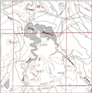 | ||||||||||||||||||||||||||||||||||||||||||||||||||||||||||||||||
| Date: | 22 Feb. 2001 | |||||||||||||||||||||||||||||||||||||||||||||||||||||||||||||||||
| Location: | SESW 35, T40N, R72W | |||||||||||||||||||||||||||||||||||||||||||||||||||||||||||||||||
| Owner: | RANCH CO. (STEVE DILTS) | |||||||||||||||||||||||||||||||||||||||||||||||||||||||||||||||||
| Year of Construction: | 1954 | |||||||||||||||||||||||||||||||||||||||||||||||||||||||||||||||||
| Enlargement History: | 1956 | |||||||||||||||||||||||||||||||||||||||||||||||||||||||||||||||||
| Total Storage: | 2029 acre-feet | |||||||||||||||||||||||||||||||||||||||||||||||||||||||||||||||||
| Active Storage: | 1345 acre-feet | |||||||||||||||||||||||||||||||||||||||||||||||||||||||||||||||||
| Dead Storage: | 28.30 acre-feet | |||||||||||||||||||||||||||||||||||||||||||||||||||||||||||||||||
| Area/Capacity Data: | (Source: .Map to Accompany Applications for First Enlargement, Betty No. 1 Reservoir, Betty No. 2 Ditch, and Betty No. 3 Ditch,. on file in Safety of Dams office, SEO, Cheyenne, Wyoming.) | |||||||||||||||||||||||||||||||||||||||||||||||||||||||||||||||||
| ||||||||||||||||||||||||||||||||||||||||||||||||||||||||||||||||||
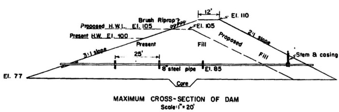
| Dam Construction Type: | Earth Fill | |||||||||||||||||||||||||||||||||||||||||||||||||||||||||||||||||
| Outlet: | Eight-inch welded steel pipe in dam; Twelve-inch welded steel pipe in dike to east of dam | |||||||||||||||||||||||||||||||||||||||||||||||||||||||||||||||||
| Spillway: | East (dam) spillway: 100 feet wide at base, 140 feet wide at dam crest, walls at 3:1 slope. Max flow: 1778.40 cfs | |||||||||||||||||||||||||||||||||||||||||||||||||||||||||||||||||
| West (dike) spillway: 515-foot-wide notch cut at approx. 3:1 slope, 5 feet deep at deepest point. Max flow: 11,553.65 cfs | ||||||||||||||||||||||||||||||||||||||||||||||||||||||||||||||||||
| End-of-Month Storage Records: | No | |||||||||||||||||||||||||||||||||||||||||||||||||||||||||||||||||
| Water Rights: | (Source: Tabulation of Adjudicated Surface Water Rights of the State of Wyoming, Water Division Number Two, Oct. 1999) | |||||||||||||||||||||||||||||||||||||||||||||||||||||||||||||||||
| ||||||||||||||||||||||||||||||||||||||||||||||||||||||||||||||||||
| Designated Use: | Irrigation | |||||||||||||||||||||||||||||||||||||||||||||||||||||||||||||||||
| Associated Irrigation Diversions: | Betty No. 2 and Betty No. 3 ditches | |||||||||||||||||||||||||||||||||||||||||||||||||||||||||||||||||
| Associated Industrial Diversions: | None | |||||||||||||||||||||||||||||||||||||||||||||||||||||||||||||||||
| Operational Discussion: | Betty No. 1 Reservoir receives water from Bear and Lonetree Creeks, and according to the permit that accompanies its first enlargement petition, two centrifugal pumps pull water from the reservoir to water the ditches on either side of the headgates. | |||||||||||||||||||||||||||||||||||||||||||||||||||||||||||||||||
| References: | Map to Accompany Applications for First Enlargement Betty No. 1 Reservoir, Betty No. 2 Ditch, and Betty No. 3 Ditch, John C. Dilts, Douglas, Wyoming, 25 Sept. 1956. | |||||||||||||||||||||||||||||||||||||||||||||||||||||||||||||||||
Betty No. 1 Dam cross section (Source: .Map to Accompany Applications for First Enlargement, Betty No. 1 Reservoir, Betty No. 2 Ditch, and Betty No. 3 Ditch,. on file in Safety of Dams office, SEO, Cheyenne, Wyoming.):
Net Evaporation from Betty No. 1 Reservoir:
| Lewis Annual Evaporation (in.) | 45 |
| Total Storage (acre-feet) | 2,029 |
| Jan | Feb | Mar | Apr | May | Jun | Jul | Aug | Sep | Oct | Nov | Dec | ||
|---|---|---|---|---|---|---|---|---|---|---|---|---|---|
| Average percent of storage | 52.1 | 55.7 | 63.8 | 67.0 | 73.3 | 74.9 | 73.5 | 71.3 | 69.2 | 51.6 | 51.3 | 51.5 | |
| Generated storage (acre-feet) | 1057 | 1129 | 1294 | 1359 | 1488 | 1519 | 1491 | 1447 | 1405 | 1046 | 1041 | 1044 | |
| Corresponding area (acres) | 121.3 | 125.1 | 133.6 | 136.9 | 143.5 | 145.1 | 143.7 | 141.4 | 139.3 | 120.8 | 120.5 | 120.7 | |
| Calculations: | |||||||||||||
| Monthly Lewis Evap. (inches) | 1.215 | 1.125 | 1.755 | 3.6 | 5.175 | 5.895 | 7.695 | 7.02 | 5.175 | 3.42 | 1.755 | 1.17 | |
| Monthly Precipitation (inches) | 0.25 | 0.25 | 0.75 | 1.75 | 2.75 | 2.25 | 1.75 | 1.25 | 1.25 | 0.75 | 0.75 | 0.25 | |
| Net Evaporation (inches) | 0.965 | 0.875 | 1.005 | 1.85 | 2.425 | 3.645 | 5.945 | 5.77 | 3.925 | 2.67 | 1.005 | 0.92 | TOTAL |
| Total Net Evaporation (acre-feet) | 10 | 9 | 11 | 21 | 29 | 44 | 71 | 68 | 46 | 27 | 10 | 9 | 355 |