Wyoming State Water Plan
Wyoming State Water Plan
Wyoming Water Development Office
6920 Yellowtail Rd
Cheyenne, WY 82002
Phone: 307-777-7626

Wyoming Water Development Office
6920 Yellowtail Rd
Cheyenne, WY 82002
Phone: 307-777-7626


| SUBJECT: |
Appendix P Population Projections |
| PREPARED BY: | Watts and Associates, Inc. |
| DATE: | February 2002 |
INTRODUCTION
This memorandum presents population projections for communities and rural areas in the Northeast Wyoming River Basins over a 30-year planning horizon. The purposes of these projections are to provide a basis for estimating future municipal and domestic water needs in the planning area, as well as provide insights into future water-based recreational resource needs.
The river basin water planning process developed by the Wyoming Water Development Commission (WWDC) specifies that population projections be developed for three planning scenarios:
The following sections of this memorandum describe the approach and methodologies utilized in developing population projections for the planning area as well as the results of the analysis.
APPROACH
Population projections can be developed using a variety of different approaches depending upon the purpose for which the projections are being developed, the amount of data available for making projections, and the time horizon over which the projections are to be made. The three most common methods for producing population projections are (1) time series analyses, (2) cohort survival analyses, and (3), employment-driven approaches.
Time series analyses typically involve assessing past growth trends and using those trends to project population into the future. Analytical methods used with this approach include computing average annual historical growth rates and fitting linear or non-linear equations to historical population data or indicators of population growth such as school enrollments, sales tax revenues, or other variables. Projections are usually based upon the assumption that future population changes will mimic past average annual growth rates or trends. The time series approach is relatively easy to implement, and its results are easily understandable. Its main disadvantage is that it does not explicitly consider the three primary determinants of regional population change: mortality rates, fertility rates, and migration patterns. Instead, the method implicitly assumes that past trends in relationships among these variables will continue into the future.
The cohort survival approach explicitly recognizes the three primary determinants of population change and requires forecasts of filture mortality and fertility rates as well as net migration patterns. Projections of mortality and fertility rates by age and sex group (cohort) are available from the U.S. Census Bureau (USCB), as are projections of net migration patterns for different regions of the country. Projections of change for each cohort can be combined to produce forecasts of future population for a given geographic area. The advantage of the cohort survival approach is that it explicitly recognizes the determinants of population change and takes them into account in developing projections. Its primary disadvantage is that in rural areas with relatively small population bases, the effects of changing migration patterns over time can overwhelm the effects of changes in mortality and fertility rates, thus making the projections extremely sensitive to assumptions about future net migration patterns.
Employment-driven approaches to population projections are based upon the assumption that net migration patterns are primarily determined by job availability, and that job availability can be projected into the future with reasonable accuracy. Thus, if we could accurately project how many jobs would be available in the planning area in the year 2030, we could estimate population in that year based upon estimates of how many people would be associated with each job. Estimates of the number of persons associated with each job may or may not explicitly take into account such factors as labor force participation rates, fertility rates, and mortality rates. If these factors are taken into account, the employment-driven approach becomes a special case of the cohort survival approach where net migration estimates are based upon employment forecasts.
The employment-driven approach incorporating labor force participation, fertility, and mortality rate changes is the most sophisticated approach commonly used for projecting regional population changes and can provide relatively accurate forecasts over relatively short time frames. Its primary disadvantage lies in the difficulty of forecasting economic activity and associated labor requirements by economic sector over long time periods. Even if future economic activity by sector could be forecast reliably 30 years into the future (a doubtful proposition), technological changes that affect the amount of labor needed by each sector often cannot be forecast reliably. For example, Wyoming's Powder River Basin has become the world's leading coal producer in recent decades with little growth in employment opportunities because of productivity gains associated with mechanized mining equipment. Accurately forecasting current levels of mining employment in the Powder River Basin 30 years ago would have been very difficult because the technology that determines current employment levels did not exist then. Another disadvantage of the employment-driven approach is that migration patterns in the United States in recent decades have become less dependent upon local job availability and more dependent upon amenities and lifestyle variables such as climate, local infrastructure, crime rates, and scenic attributes. Many industries and jobs in the U.S. economy are now "portable" in the sense that they can be shifted from one locale to another based upon amenities or lifestyle variables with little change in competitive advantage.
Given the inherent shortcomings of all three population projection methodologies, there is no compelling reason to generate population projections for the planning area using one method to the exclusion of others. Instead, the approach taken for this study involves using three different methods to create a range of projections representative of low, moderate, and high growth scenarios. Those methods are discussed below, following a discussion of historic population growth trends.
HISTORIC AND CURRENT POPULATION ESTIMATES
The first step in developing population projections was to examine historic population trends in the planning area and the current population of its counties, communities and rural areas. The best source of information on historic and current population is the results of the U.S. Census conducted at IO-year intervals. Historical census information is readily available and the Census Bureau recently released the results of the 2000 Census (Wyoming Department of Administration and Information [WDAI], 2001a).
Because the geographical boundaries of the planning area do not adhere to county lines, it was necessary to adjust the Census Bureau's county population estimates to reflect only the proportion of each county that lies within the planning areas' boundaries. The process that was followed is described below:
An exception to this process was used to allocate the rural population of Campbell County. Although only 43.4 percent of the land area in Campbell County is located in the planning area, most of the rural population growth in Campbell County in recent decades has occurred to the east and south of Gillette in the Belle Fourche River Basin. According to the Campbell County Engineer, approximately 90 percent of rural housing construction outside of Gillette has occurred in the Belle Fourche River Basin and only 10 percent in the Powder River Basin (Zahn, 2001). For that reason, post-1960 population estimates for rural areas of Campbell County are based upon the assumption that 90 percent of the county's rural population growth occurred in the planning area.
Population estimates for cities, towns, and rural areas of the Northeast Wyoming River Basins during the period from 1960 through 2000 are presented in Table 1. The results in that table show that the total population of the planning area grew from about 21,800 in 1960 to almost 43,500 in 1990. By the year 2000, planning area population had grown to over 48,460. That figure represents about 10 percent of Wyoming's total population of 493,782 according to the 2000 Census. Population growth in the Northeast Wyoming River Basins has averaged over 2.01 percent annually over the past four decades. This growth rate is significantly higher than comparable growth rates for the State of Wyoming. Over the 40-year period from 1960 through 2000, Wyoming's average annual population growth rate was 1.01 percent.
| Table 1 - Northeast Basin Population Estimates 1960-2000 (revised 6-26-01) | |||||
| Entity | Population |
1960-2000 % Change | |||
| 1960 | 1990 | 2000 | |||
| Cambell Cty | |||||
| Gillette | 3,580 | 17,635 | 19,646 | 448.8% | |
| Wright | NA | 1,236 | 1,347 | NA | |
| Rural | 990 | 8,386 | 10,372 | 947.7% | |
| 4,570 | 27,257 | 31,365 | 586.3% | ||
| Converse Cty | 1,071 | 1,953 | 2,237 | 108.9% | |
| Crook Cty | |||||
| Hulett | 335 | 429 | 408 | 21.8% | |
| Moorcroft | 826 | 768 | 807 | -2.3% | |
| Pine Haven | NA | 141 | 222 | NA | |
| Sundance | 908 | 1,139 | 1,161 | 27.9% | |
| Rural | 2,622 | 2,817 | 3,289 | 25.4% | |
| 4,691 | 5,294 | 5,887 | 25.5% | ||
| Niobrara Cty | |||||
| Lusk | 1,890 | 1,504 | 1,447 | -23.4% | |
| Manville | 124 | 97 | 101 | -18.5% | |
| Van Tassell | 15 | 8 | 18 | 20.0% | |
| Rural | 1,557 | 805 | 761 | -51.1% | |
| 3,586 | 2,414 | 2,327 | -35.1% | ||
| Weston Cty | |||||
| Newcastle | 4,345 | 3,185 | 3,065 | -29.5% | |
| Upton | 1,224 | 980 | 872 | -28.8% | |
| Rural | 2,360 | 2,353 | 2,707 | 14.7% | |
| 7,929 | 6,518 | 6,644 | -16.2% | ||
| TOTAL BASIN | 21,847 | 43,436 | 48,460 | 121.8% | |
| WYOMING | 330,066 | 453,588 | 493,782 | 49.6% | |
The Northeast Wyoming River Basins growth rates have slowed somewhat in recent years, however. From 1960 to 1990, the planning area's average annual rate of population increase was 2.32 percent. During the period from 1990 through 2000, the population growth rate dropped to 1.10 percent annually. Part of this drop may simply reflect the fact that the population base in 1990 was much larger than it was in 1960.
Much of the historical population growth in the Northeast Wyoming River Basins is attributable to development of energy and mineral resources in the region. The 1970s and early 1980s saw the development of a number of large surface coalmines in the planning area, along with several uranium mines. Coal-fired electric generating facilities were also constructed during that period, and at one time there was interest in developing the area's coal resources to produce synthetic fuels. Population growth slacked off somewhat in the late 1980s and early 1990s as energy prices fell and coal producers began to implement more efficient production techniques involving less labor and more reliance on heavy equipment. The recent flurry of interest in coal-bed methane production has resulted in increased economic activity and population growth in some parts of the planning area.
One conclusion that can be drawn for the population estimates in Table 1 is that not all areas have shared in the planning area's overall population growth in recent decades. Population growth in eastern Campbell County was dramatic from 1960 to 2000, growing from 4,570 persons to 31,365 persons, an increase of over 585 percent. The populations of northern Converse County and Crook County also grew during this period, although at a less dramatic rate than in Campbell County. Niobrara and Weston Counties, however, lost significant portions of their populations over the past 40 years while other parts of the planning area were growing. The population declines in Niobrara and Weston Counties can be attributed to the lack of developable energy and mineral resources and a heavy reliance upon agriculture as an economic base. Agriculture, like many other industries, has become more mechanized and less labor intensive over the past four decades. With no significant changes in the agricultural land base of these counties, there have been fewer and fewer jobs for area residents and a resulting decrease in population.
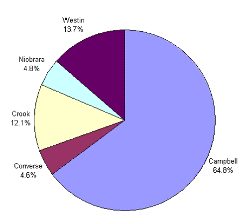
The geographical distribution of the planning area's current population (based upon the 2000 Census) is depicted in Figure 1. That figure shows that almost 65 percent of the planning area's population resides in Campbell County. Another 13.7 percent reside in Weston County, and 12.1 percent live in Crook County. Niobrara County and rural areas of northern Converse County account for 4.8 and 4.6 percent of the planning area's population, respectively.
Figure 1
Distribution of Current Population
Northeast Wyoming
POPULATION PROJECTIONS
Population projections through the year 2030 for planning area communities and rural areas were developed using three different approaches to produce high, moderate, and low growth scenario projections. Those three approaches are described in the following three subsections. The fourth subsection describes the results of the analysis.
Extended WDAI Projections
The Division of Economic Analysis of the WDAI produces population forecasts for Wyoming counties, cities, and towns (WDAI, 2001b). The county population forecasts are based upon time series data from which growth rates are derived from variables such as population, sales tax collections, and school enrollments. These growth rates are used to forecast individual county population totals, and these county totals are adjusted to make them consistent with state-level population forecasts that incorporate elements of the cohort survival and employment-driven approaches. Population projections for cities and towns within each county are based upon population "shares" as derived from census counts or estimates.
The state-level forecasts are employment-driven with respect to magnitude, although they explicitly take into account fertility, mortality, and migration patterns by cohort. The state population forecast totals are controlled to match employment projections produced by Wharton Econometric Forecast Associates under contract with the Division of Economic Analysis. Thus, the total county-level projections are essentially employment-driven also.
The Division of Economic Analysis forecasts population only 10 or fewer years into the future because of the uncertainties associated with such projections. Its most recent projections are through the year 2008 and are relatively conservative, a reflection of the relatively slow economic growth that many parts of the state have witnessed in recent years. A reasonable set of low growth rate population projections for the planning area can be derived by computing the WDAI's average annual population growth rates for planning area communities and rural areas for the period from 1990 through 2008 and extending those growth rates through the year 2030.
Allocation of U.S. Census Bureau Projections
The U.S. Census Bureau (USCB) periodically produces population forecasts for each of the 50 states using the cohort survival approach. The most recent forecasts for the state of Wyoming are two sets of population projections through the year 2025, the Series A forecasts and the Series B forecasts (USCB, 2001). Both series of projections use the cohort-survival approach and incorporate the USCB's "middle series" projections of fertility and mortality rates by cohort for each state. Both series also use migration patterns based upon recent data (early 1990s) concerning address changes reported on federal income tax returns. The only difference between the Series A and Series B projections is that the latter are adjusted slightly to make them more consistent with employment projections by state issued by the Bureau of Economic Analysis of the U.S. Department of Commerce. There is no significant difference between the Series A and Series B population forecasts for the state of Wyoming.
Both series of projections indicate moderate future population growth for Wyoming based upon migration patterns in the early 1990s. During that period, there was a moderate influx of new residents into some parts of Wyoming from elsewhere in the country. The effects of this migration pattern are apparent in some parts of the planning area, including the Sundance area. The USCB projections are based upon the assumption that this moderate rate of net in-migration will continue into the future, and that fertility and mortality rates for the state will follow the USCB's middle series projections.
A reasonable set of moderate growth population projections for the planning area can be developed from the USCB's Series A projections for Wyoming using the following methodology:
Historical Growth Projections
A third set of planning area population projections was developed from historical growth rates for communities and rural areas in the planning area. As discussed above, the planning area experienced population growth rates from 1960 to 1990 that averaged 2.32 percent annually. The average population grow rate then dropped to 1.10 percent form 1990 to 2000. The 1960-90 growth rate of over 2 percent annually is unlikely to be repeated in the future because the planning area now has a much larger population base, meaning that each new population increment will represent a smaller percentage increase than before. For this reason, a set of high growth population projections was developed by assuming that the absolute population growth experienced during the 1960-90 period would occur again between the years 2000 and 2030.
Results
The three methods described above were used to generate population forecasts through the year 2030 for each community and rural area in the planning area. Generally speaking, the WDAI extended forecasts resulted in the smallest population projections, followed by the U.S. Census Bureau projections and the historical growth projections in that order. There were some exceptions to this generality, however, primarily because some communities have experienced population declines that were projected to continue over the next 30 years in the historical growth scenario. In some cases, these communities were projected to have higher growth rates (or less severe population declines) in one of the other two scenarios.
To adjust for such anomalies, the high growth scenario for each community and rural area was defined as the largest population forecast for 2030 generated by any of the three methods. Similarly, the low growth scenario was defined as the lowest population forecast, and the moderate growth scenario was defined as the middle 2030 population forecast. The results of the low, moderate, and high growth projections for the entire planning area are depicted graphically in Figure 2.
Figure 2
Low, Moderate, and High Growth Population Projections
Northeast Basin
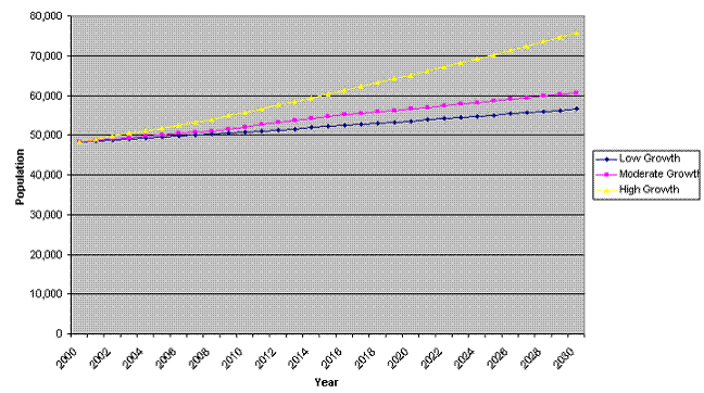
Figure 2 shows that the low growth scenario projects a relatively modest increase in planning area population over the next 30 years, from about 48,500 persons in the year 2000 to 56,600 persons by the year 2030. This increase is based upon WDAI projected growth rates for the area, and corresponds to an average annual population growth rate of 0.52 percent. This growth rate is lower than historical growth rates in recent decades, but represents a reasonable low growth scenario forecast because the population base of the area is larger than was historically. On an absolute basis, the low growth scenario corresponds to a population increase of almost 8,200 persons.
The moderate growth scenario projects that the planning area's total population will grow to 60,670 persons by the year 2030. That result is based upon Census Bureau projections, and represents an increase of 12,210 persons relative to the 2000 Census. The corresponding average annual growth rate is 0.75 percent annually, which is lower than historical growth rates but almost 50 percent higher than the growth rate projected for the low growth scenario.
The high growth scenario results show that the planning area's population is expected to grow to about 75,900 persons by the year 2030, an increase of over 27,000 persons relative to the 2000 Census. This result is based upon the assumption that the absolute population growth that occurred during the boom period from 1960 to 1990 will be repeated over the next 30 years. It corresponds to an average annual growth rate of 1.51 percent and a total population increase of about 57 percent over the next 30 years.
Low, moderate, and high growth projections for communities and rural areas are given in Tables 2 through 4. The results in Table 2 indicate that under low growth assumptions, some communities and rural areas will continue modest growth. The growth areas for this scenario include Campbell County and its communities, as well as rural areas of Converse and Crook Counties and the communities of Hulett, Pine Haven, and Sundance. Niobrara County and its communities and Weston County and its communities are expected to experience population declines under the low growth scenario. These projections are reflections of past population trends in those parts of the planning area.
| Table 2-Northeast Basin Population Projections Low Growth Scenario | |||
| Entity | Population | Percentage Increase | |
| 2000 | 2030 | ||
| Cambell Cty | 31,365 | 40,207 | 28.2% |
| Gillette | 19,646 | 25,175 | 28.1% |
| Wright | 1,347 | 1,742 | 29.3% |
| Rural | 10,372 | 13,291 | 28.1% |
| Converse Cty | 2,237 | 2,758 | 23.3% |
| Crook Cty | 5,887 | 6,335 | 7.6% |
| Hulett | 408 | 472 | 15.8% |
| Moorcroft | 807 | 749 | -7.2% |
| Pine Haven | 222 | 239 | 7.5% |
| Sundance | 1,161 | 1,393 | 20.0% |
| Rural | 3,289 | 3,482 | 15.9% |
| Niobrara Cty | 2,327 | 1,530 | -34.2% |
| Lusk | 1,447 | 1,061 | -26.7% |
| Manville | 101 | 74 | -26.7% |
| Van Tassell | 18 | 11 | -38.9% |
| Rural | 761 | 384 | -49.5% |
| Weston Cty | 6,644 | 5,809 | -12.6% |
| Newcastle | 3,065 | 2,483 | -19.0% |
| Upton | 872 | 628 | -28.0% |
| Rural | 2,707 | 2,699 | -0.3% |
| TOTAL BASIN | 48,460 | 56,639 | 16.9% |
Population projections for the moderate growth scenario are given in Table 3. For this scenario, all areas of the planning area except Weston County are expected to experience at least some population growth over the next 30 years. The population of Weston County and the communities of New Castle and Upton are expected to remain flat under moderate growth assumptions. The fastest growing areas in the planning area are expected to be rural areas of eastern Campbell County and the communities of Gillette and Wright. Significant growth is also expected in rural areas of Converse County, as well as Crook and Niobrara Counties and their communities.
| Table 3 - Northeast Basin Population Projections Moderate Growth Scenario | |||
| Entity | Population | Percentage Increase | |
| 2000 | 2030 | ||
| Cambell Cty | 31,365 | 41,263 | 31.6% |
| Gillette | 19,646 | 25,843 | 31.5% |
| Wright | 1,347 | 1,777 | 31.9% |
| Rural | 10,372 | 13,644 | 31.5% |
| Converse Cty | 2,237 | 2,904 | 29.8% |
| Crook Cty | 5,887 | 7,086 | 20.4% |
| Hulett | 408 | 501 | 22.9% |
| Moorcroft | 807 | 995 | 23.3% |
| Pine Haven | 222 | 275 | 24.0% |
| Sundance | 1,161 | 1,402 | 20.7% |
| Rural | 3,289 | 3,912 | 18.9% |
| Niobrara Cty | 2,327 | 2,773 | 19.2% |
| Lusk | 1,447 | 1,711 | 18.2% |
| Manville | 101 | 122 | 21.1% |
| Van Tassell | 18 | 18 | 0.0% |
| Rural | 761 | 922 | 21.1% |
| Weston Cty | 6,644 | 6,644 | 0.0% |
| Newcastle | 3,065 | 3,065 | 0.0% |
| Upton | 872 | 872 | 0.0% |
| Rural | 2,707 | 2,707 | 0.0% |
| TOTAL BASIN | 48,460 | 60,670 | 25.2% |
Population projections for the high growth scenario are presented in Table 4. For this scenario, all communities and rural areas of the planning area are expected to experience significant growth over the next 30 years. The fastest growing area is projected to be in eastern Campbell County and the communities of Gillette and Wright. These areas are expected to experience a 72.2 percent population increase over the next 30 years.
| Table 4 - Northeast Basin Population Projections High Growth Scenario | |||
| Entity | Population | Percentage Increase | |
| 2000 | 2030 | ||
| Cambell Cty | 31,365 | 53,996 | 72.2% |
| Gillette | 19,646 | 33,650 | 71.3% |
| Wright | 1,347 | 2,580 | 91.5% |
| Rural | 10,372 | 17,765 | 71.3% |
| Converse Cty | 2,237 | 3,199 | 43.0% |
| Crook Cty | 5,887 | 7,646 | 29.9% |
| Hulett | 408 | 519 | 27.1% |
| Moorcroft | 807 | 1,048 | 29.8% |
| Pine Haven | 222 | 363 | 63.4% |
| Sundance | 1,161 | 1,497 | 28.9% |
| Rural | 3,289 | 4,219 | 28.3% |
| Niobrara Cty | 2,327 | 2,987 | 28.4% |
| Lusk | 1,447 | 1,853 | 28.0% |
| Manville | 101 | 130 | 29.1% |
| Van Tassell | 18 | 22 | 21.1% |
| Rural | 761 | 982 | 29.1% |
| Weston Cty | 6,644 | 8,044 | 21.1% |
| Newcastle | 3,065 | 3,712 | 21.1% |
| Upton | 872 | 1,055 | 21.0% |
| Rural | 2,707 | 3,278 | 21.1% |
| TOTAL BASIN | 48,460 | 75,872 | 56.6% |
Crook and Niobrara Counties would experience population increases approaching 30 percent under this scenario, while Weston County would experience a 21 percent population increase. Total population would increase from 48,460 in the year 2000 to 75,872 in 2030 under the high growth scenario.
REFERENCES
State of Wyoming. 1999. Equality State Almanac, 1998. Department of Administration and Information. Division of Economic Analysis. April.
State Engineers Office. 1972. Water and Related Land Resources of Northeastern Wyoming. Wyoming Water Planning Program Report No. 10. April.
U.S. Census Bureau. 2001. Population Projections: States, 1995-2005. Available World Wide Web@ http://www.census.gov/population/projections/stproj.html
Wyoming Department of Administration and Information. 2001a. Population for Counties and Incorporated Places: 1990 and 2000. Division of Economic Analysis. Available World Wide Web @ http://eadiv.state.wv.us/demog_data/pop2000/antycity_90_00.htm
Wyoming Department of Administration and Information. 200 Ib. Wyoming Population Estimates and Forecasts for Counties, Cities, and Towns. Division of Economic Analysis. Available World Wide Web @ http://eadiv.state.wy.us/pop/wyc&sc98.html
Zahn, Matthew. 2001. Personal Communication. Campbell County Engineer. June 26.
--------------------------
1A small portion of the City of Gillette is located in the Powder/Tongue River Basin. The vast majority of the city's
land area and population are located in this planning area, however, so it was classified as belonging totally in that
basin for planning purposes and is treated as such in this memorandum.
2 A small portion of rural Crook County lies in the Powder River Basin. Since the area is small and virtually unpopulated, all of Crook County was included in the planning area for planning purposes.