Wyoming State Water Plan
Wyoming State Water Plan
Wyoming Water Development Office
6920 Yellowtail Rd
Cheyenne, WY 82002
Phone: 307-777-7626

Wyoming Water Development Office
6920 Yellowtail Rd
Cheyenne, WY 82002
Phone: 307-777-7626


| SUBJECT: |
Appendix C Irrigated Lands Mapping and Water Rights Data |
| PREPARED BY: | HKM Engineering Inc. and Lord Consulting, LLC |
| DATE: | February 2002 |
INTRODUCTION
Irrigated agriculture represents the greatest consumption of water within the boundaries of the Northeast Wyoming River Basins Plan area. An accurate estimate of existing irrigation water use is therefore central to a comprehensive water use inventory. Estimates of water use by irrigated agriculture can generally be divided into the following three components:
This memorandum summarizes the methodology used to map the existing irrigated lands. The methodology used to determine the types of crops grown and their geographic distribution is summarized in the memorandum "Irrigated Crops" (HKM, 2002). The methodology used to determine the amount of water consumed by the irrigated lands is summarized in the memorandum "Agricultural Water Use" (HKM, 2002).
AERIAL PHOTOGRAPHY INTERPRETATION AND MAPPING
HKM obtained 1994 to 1996 National Aerial Photography Program (NAPP), 1:40,000 scale, black and white imagery as the primary basis for the mapping of irrigated lands. A total of approximately 1,250 images were acquired for the planning area. Highly transparent single matte Mylar was used for mapping directly over the aerial photographs. Mapping was performed by viewing the imagery 3-dimensionally, using a Lietz MS-27 three-power track stereoscope.
All man induced irrigation or subirrigation was delineated. Natural subirrigated fields were not delineated unless some benefit was being received from a man made system. Irrigated lands were divided into the following categories based on visual interpretations of the quality of the irrigation, types of crops supported, and the type and condition of the irrigation delivery systems and on-farm systems used to serve these lands:
A - Full service irrigation (typically receives a full water supply);In addition to mapping the irrigated lands, the irrigation systems used to deliver water to these lands were also mapped. Features mapped include the point of diversion, main delivery canals, flumes, siphons, and pump and well locations. Buried pipelines were also mapped to the extent that traces of the excavation could be identified. This information was necessary to clearly define the tributary source of water supply to the lands and for the purpose of grouping lands into Service Areas. Service Areas are defined here as groupings of lands served by common supply ditches. Available records of historical ditch diversions together with the number of irrigated acres served by those ditches (acreage within the given Service Area) as well as the irrigation classification of those lands and the type of crops grown, provide the necessary information to make reliable estimates of actual water use by lands throughout the study area. This is discussed in more detail in the "Agricultural Water Use" memorandum (HKM, 2002).
B - Partial service irrigation (typically receives a reduced water supply due to limited water availability or the inability to provide complete field coverage);
C - Man induced subirrigation (beneficial use resulting from incidental irrigation such as ditch seepage to areas below a canal);
E - Idle irrigation (lands not currently receiving water, typically due to nonfunctional delivery facilities);
S - Spreader dike irrigation (dikes constructed across ephemeral streams to spread infrequent flows over the land to increase beneficial use);
H - Minor beneficial use, (lands that receive some beneficial use on occasion such as lands served by "kick-out" ditches on ephemeral streams).
AD, BD, and ED . A, B, or E lands that have underwent or are currently undergoing residential development.
The mapped information including the irrigated land boundaries and irrigation facilities was projected from the aerial photographs to Mylar transparency overlays on USGS 7.5' quadrangle maps using a Bausch and Lomb zoom transfer scope. This process utilizes triangulation rectification to eliminate all scale differences, tilt, tip, and topographically misplaced information to ensure proper geo-location. This rectification step provided a positional accuracy of 25' or less which exceeds the national map accuracy standard of 40' specified for this study. The various mapped features were color-coded with canals and ditches mapped in blue, irrigated fields in red, and roads and other cultural changes affecting irrigation boundaries in black.
The 1:24,000 scale, positionally rectified, mapping of irrigation polygons (isolated tracts of irrigation) were digitized into AutoCAD files which were subsequently converted to ArcView shape files. Where A, B, and/or C lands were joined contiguously, the lands were digitized as a single polygon of irrigation with an attribute to reflect the multiple classifications (i.e. AB, AC, or ABC). A very minor amount of non- irrigated land such as minor roads and cultural features is included in the mapping of irrigated lands. Farm lanes and field roads with corridor widths of less than 40 feet are generally included in the polygons of irrigation, as they are considered to be insignificant to the overall extent of irrigation. Roads with defined borrow pits and fenced right-of-ways were generally eliminated. For those polygons of irrigation given an AD, BD or ED designation, essentially all roads and residences are included in the boundaries of the respective polygons. Quality control was performed for every polygon on every mapped quadrangle to ensure accuracy and completeness. To ensure proper registration, the four corners of every PLS section containing irrigated lands on the 1:24,000 scale work maps were calibrated to the same four sections in the digital PLS. The digitized polygons for every mapped quadrangle were plotted on vellum "proof maps". The "proof maps" were superimposed over the original work maps to check for completeness and line quality of the digitized polygons.
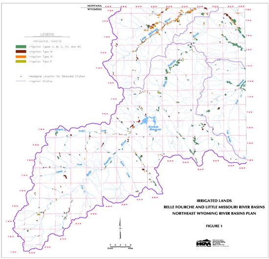
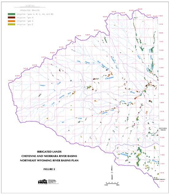
The extent of irrigated land within the Northeast Wyoming River Basins is shown on Figures 1 and 2. A typical area of irrigated lands mapping is illustrated on Figure 3 at a 1:24,000 scale.
OTHER IMAGERY AND INFORMATION USED TO CROSS-CHECK MAPPING
HKM also obtained the 1983 Color Infrared (CIR), 1:24000 aerial imagery available from WWDC. This photography was very valuable for the purpose of viewing the lands in another "snapshot" in time to confirm the mapping. This information is unfortunately not available for the entire study area nor is it available stereoscopically.
HKM also utilized the Tabulation of Adjudication Surface Water Rights of the State of Wyoming (SEO, 1999), ditch plat maps obtained from the State Engineers Office, and a listing of irrigation wells within the study area, to double-check areas of prospective irrigation.
The water rights attribution task, to be discussed in a later section, provided another opportunity for review of the thoroughness and completeness of the irrigated lands mapping.
DIGITAL BASE MAPS
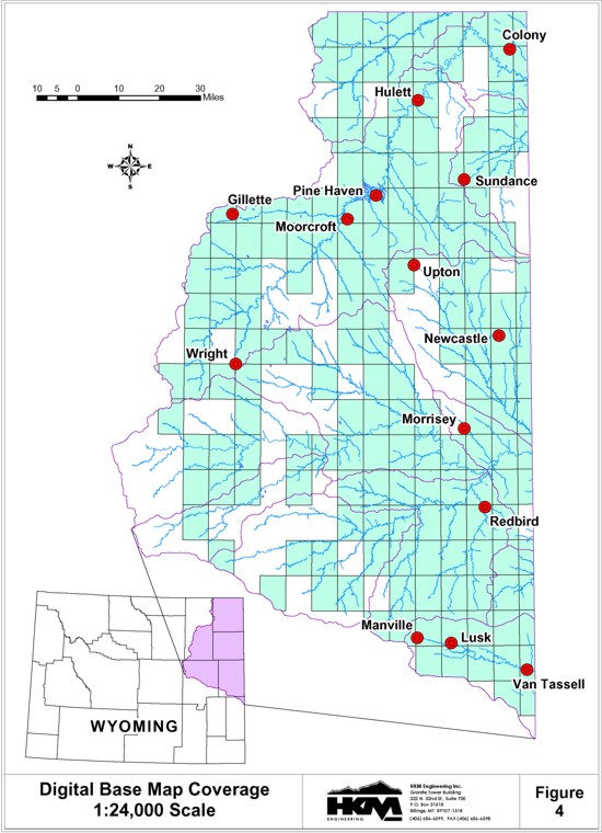
HKM obtained approximately 160 7.5-minute vectorized digital base maps developed from USGS quadrangle maps. This information is intended to serve as base maps providing perspective in the areas of irrigation. These digital base maps were obtained from Geographic Information Systems in McAllen, Texas in the form of AutoCAD files. The extent of the digital base map coverage for the Northeast Wyoming River Basins is shown on Figure 4. HKM also digitized portions of several additional quadrangles, which had only a very minor amount of irrigation. All of the various quadrangle maps and portions of quadrangle maps were joined together and then separated into the following ArcView data themes:
FIELD VERIFICATION
Following the digitizing process, maps of the irrigated lands were submitted to the State Engineers Office Division 2 Superintendent in Sheridan for review. No significant changes to the mapping arose from this review.
WATER RIGHTS ATTRIBUTION
Purpose
The water rights attribution task entails identifying and describing the water rights attached to the irrigated lands polygons. This task is included in the river basin planning process for two reasons. First, knowing the water rights attached to the polygons provides additional understanding of the source of supply and the irrigation systems that deliver water to the polygons. This increased understanding contributes to the accuracy and reliability of the service area designations used to group lands by source of supply.
The second reason for the water right attribution task is to define the water resources of the basin. A description of irrigated lands is not complete unless it includes a definition of the water rights granted to allow for irrigation of those lands.
The water right attribution process involves three steps: 1) land description development; 2) water right identification; and, 3) water right attribution. Each of these steps is discussed below. The product of the water right attribution process is a water rights database that includes identified water rights and their attributes. This database, when linked to the irrigated lands polygons through the Geographic Information System (GIS), allows the user to identify the water rights attached to the polygons of irrigated land.
Step 1: Land Description Development
The first step in the process is to describe the polygons in a format compatible with water rights records maintained by the Wyoming State Engineer and the State Board of Control. This step involves converting the polygons, which are mapped on USGS quadrangle maps having a scale of 1:24,000, to a land description based on the Public Land Survey System (PLSS). This visual conversion resulted in a land description of each polygon to the nearest quarter-quarter of a Section, or to the nearest lot or tract in the case of a resurveyed Township.
Step 2: Water Right Identification
Given the land description of a polygon, the township plats in the office of the Wyoming State Engineer and the State Board of Control were used to identify the water rights attached to that polygon. These township plats describe the water rights attached to each quarter-quarter, lot, and tract on the plat. There are two different township plats: 1) "linen" plats describe water rights that have been adjudicated by the State Board of Control; and 2) "paper" plats describe all water rights and therefore provide information on the unadjudicated water rights. On the linen plats water rights are identified by Proof Number with a reference to the Order Record Book and Page numbers where all attribute information on that water right is entered at the time the right is adjudicated. Water rights are identified on the paper plats by Temporary File Number or Permit Number. In the event the township plats revealed no water rights for the lands occupied by the polygon, the polygon was assigned a water right number of 0 (zero).
Within the scope of river basin planning, the township plats are the only means available to identify water rights attached to a particular parcel of irrigated land. Legibility and consistency of presentation are issues with these plats, most of which date back to territorial days.
As stated above, land descriptions for unadjudicated water rights are presented on the paper plats. One issue with these paper plats is that when a water right becomes adjudicated, notification of this action is not consistently made on the paper plats and the same right can be identified twice for the same parcel of land, once as unadjudicated and again as adjudicated. Further, there is no indication if the State Board of Control adjudicated all of the right, or if a portion of the lands under the right remain unadjudicated. In these instances the assumption was made that the portion of the right that had not been adjudicated had been eliminated from the water right by the Board of Control.
The process of identifying water rights from the township plats can result in the assignment of water rights to a polygon that does not receive water under those water rights. This situation occurs when multiple ditches irrigate land in one quarter-quarter, lot, or tract. For example, if the Jones Ditch irrigates 10 acres in the NE¼ SE¼ of Section 22, and the Smith Ditch irrigates 15 acres in the same quarter- quarter, then the Jones Ditch and Smith Ditch water rights will be assigned to all polygons that include the NE¼ SE¼ of Section 22 in their land description, whereas in fact one polygon may be served by the Jones Ditch and another by the Smith Ditch. Resolution of this issue is beyond the scope of river basin planning.
A second issue resulting from this identification process is the listing of a water right to a polygon multiple times, i.e. the Frank Ditch could be listed multiple times for polygon #2304. This occurs in the case of adjudicated water rights that are presented on the linen plats by Proof Number rather than by individual water right. Water rights can be adjudicated under multiple Proof Numbers. This issue of multiple listing of water rights is exacerbated by the convention of assigning right numbers to water rights according to the township plat from which they were identified. If a water right also appears on an adjacent plat, or plats, then that water right will have a unique right number for each township plat on which it appears. For example, Right Number 5283006 is the sixth right identified from the township plat for Township 52 North, Range 83 West. If this water right also appears on the plat for Township 52 North, Range 82 West, then it could have Right Number 5282115 and both of the right numbers will be listed for a single polygon.
Groundwater rights attached to the irrigated lands polygons were identified from two sources, the township plats and the computer water right database maintained by the Wyoming State Engineer's Office. The method used to identify groundwater rights from the township plats was the same as used to identify surface water rights. However, only adjudicated rights can be identified from township plats. For unadjudicated groundwater rights it was necessary to use the water right database that provides land descriptions for the land appropriated under the groundwater permit. Land descriptions acquired from the database are compared to the land descriptions developed for the polygons to identify water rights attached to the polygons. These water rights were identified by permit number.
An alternative to using the computer database for groundwater identification is to use the County Groundwater Books on file in the State Engineer's Office. These books contain information on all well permits within a county, but they do not identify the lands irrigated by the wells. Consequently, these books can only be used to identify wells with irrigation use, then it is necessary to determine the lands irrigated by the well from the permit books. This two-step process using both the County Groundwater Books and the permit books was not necessary since the information in the County Groundwater Books is extracted directly from the computer database and the database is, in fact, more current than the County Groundwater Books.
Step 3: Water Right Attribution
After the water rights attached to the irrigated lands polygons had been identified, the next step in the process was to define the attributes of those water rights. The following is a list of the attributes acquired for each of the water rights:
Some of the adjudicated water rights were not found in the computer database, and the database did not include all of the attributes for some of the rights. For these rights the attributes were extracted from the Order Record Books filed in the vault in the office of the State Board of Control. Attributes obtained from the Order Record Books were also proofed against the Tab Books.
For unadjudicated surface water rights, the Permit Number or Temporary File Number were used to query the computer database to extract the attributes. Attributes of water rights not found in the database, or specific attributes missing from the database were collected from the permit books, entry record books, and permit applications.
The point of diversion and means of conveyance of some of the ditches, or portions of some of the ditches, have been changed, through procedures adopted by the State Engineer and the State Board of Control, to other ditches. In these instances the facility name attribute includes the name of the original ditch followed by the receiving ditch in parentheses. For example, if the point of diversion and means of conveyance for all or a portion of the lands irrigated under the Jones Ditch have been changed to the Smith Ditch, the facility name for this right would be written as Jones (Smith). The word "ditch" is omitted from but implied in the facility name unless otherwise specified. No quantification was made of the extent of the change, i.e. how many of the acres were changed and how many were not.
Attributes for adjudicated groundwater rights were obtained from the computer database and proofed against the Tab Books. Some of the adjudicated groundwater rights were not found in the computer database, and the database did not include all of the attributes for some of the rights. For these rights the attributes were extracted from the Order Record Books filed in the vault in the office of the State Board of Control. Attributes obtained from the Order Record Books were also proofed against the Tab Books.
For unadjudicated groundwater rights, the Permit Number or Temporary File Number were used to query the computer database to extract the attributes. Attributes of water rights not found in the database, or specific attributes missing from the database were collected from the permit books, entry record books, and permit applications.
GIS IRRIGATION DATA THEMES
The final work products from the irrigated lands mapping task include the following primary GIS data themes:
Irrigated LandsThe following databases were also developed:
Points of Diversion
Water RightsThe "association" database provides the information necessary to link the water rights to the irrigated lands polygons and the polygons to the points of diversion (service areas).
Water Rights to Polygons to Points of Diversion Associations
This data structure allows the information to be used in a number of ways including the following:
By selecting a Point of Diversion in the GIS, all associated Irrigated Land Polygons in the service area are selected as well as all Water Rights associated with these polygons.
By selecting an Irrigated Land Polygon in the GIS, the particular Point of Diversion for this polygon is selected as well as all of the Water Rights associated with this polygon.
By selecting a record in the Water Rights database table, the Point of Diversion associated with this water right is selected as well as any Irrigated Land Polygons attached to this water right.
The USGS quadrangle and Hydrologic Unit Code (HUC 4) basin boundary are also designated for each irrigated land polygon. Therefore the USGS Quadrangle or HUC 4 basin can be similarly used to select all associated Points of Diversion and/or Water Rights and/or Irrigated Land Polygons.
Other GIS data themes developed for this project related to irrigated lands are listed as follows:
Agricultural wellsDescriptions of the data fields contained in the GIS and tabular databases mentioned above are provided in the following sections. Each of the GIS data themes are provided in both the Universal Transverse Mercator coordinate system and the North American Datum of 1927 (*utm27.*) as well as in the geographic coordinate system of decimal degrees of latitude and longitude and the North American Datum of 1927 (*dd27.*).
Storage Reservoirs
Irrigated Lands (GIS polygon shape file, NEIrr_utm27.shp and NEIrr_dd27.shp)
| PolyId | Polygon identification number. Used to link to "PolyId" in NEIrrServ |
| Irrtype | Irrigation classification (A, B, C, E, S, H, AB, AC, ABC, AD, BD, ED) |
| Classfctn | Description of irrigation classifications as described earlier in this memorandum |
| Acreage | Area of polygon in acres |
| Station1 | Climatic station 1 used to estimate crop water requirements |
| Station2 | Climatic station 2 used to estimate crop water requirements |
| Stat1Perc | Percent weighting applied to climatic station 1 |
| Stat2Perc | Percent weighting applied to climatic station 2 |
| Alfalfa | Percentage of total acreage in alfalfa |
| Grain | Percentage of total acreage in grain crops |
| Corn | Percentage of total acreage in corn |
| Grass | Percentage of total acreage in pasture grass or grass hay |
| EffPat | Monthly irrigation efficiency pattern number |
| LagPat | Monthly return flow lag pattern number |
| ClimArea | Climate area name |
| HUC_Number | Hydrologic Unit Code (HUC) level 4 number |
| Reg_Name | HUC region name |
| Sub_Name | HUC subregion name |
| Acc_Name | HUC accounting name |
| Cat_Name | HUC cataloging name |
| MjrBasin | Major river system name (e.g. Belle Fourche River) |
| USGS_Qd_Id | USGS 7.5" quadrangle index number |
| Quad_Name | USGS 7.5" quadrangle name |
| HKM_Id | HKM quadrangle index number |
| Dgtl_Base | USGS 7.5" quadrangle digital base (Yes, No) |
Points of Diversion (GIS point shape file, NEPODs_utm27.shp and NEPODs_dd27.shp)
| ServAreaId | Point of diversion (Service Area) identification number. Used to link to "ServAreaId" in NEIrrServ.dbf |
| Ditch | Name of ditch as it appears on the quadrangle maps |
| Div_Node | Diversion node number used in water availability model |
| Return1 | Designation of 1st return node used in water availability model |
| Return2 | Designation of 2nd return node used in water availability model |
| Return3 | Designation of 3rd return node used in water availability model |
| Return4 | Designation of 4th return node used in water availability model |
| Ret1Perc | Percent of total returning to return node 1 in model |
| Ret2Perc | Percent of total returning to return node 2 in model |
| Ret3Perc | Percent of total returning to return node 3 in model |
| Ret4Perc | Percent of total returning to return node 4 in model |
| HUC_Number | Hydrologic Unit Code Level 4 number |
| Reg_Name | HUC region name |
| Sub_Name | HUC subregion name |
| Acc_Name | HUC accounting name |
| Cat_Name | HUC cataloging name |
| MjrBasin | Major river system name (e.g. Belle Fourche River) |
| USGS_Qd_Id | USGS 7.5" quadrangle index number |
| Quad_Name | USGS 7.5" quadrangle name |
| HKM_Id | HKM quadrangle index number |
| Dgtl_Base | USGS 7.5" quadrangle digital base (Yes, No) |
Water Rights (Tabular database, NEIrrRights.dbf)
| RightNo | Identification number for water right.
Used to link to "RightNo" field in NEIrrServ.dbf |
| PerPfx | Permit prefix |
| PerNo | Permit number (numerical portion only) |
| PerSfx | Permit suffix |
| Permit_No | Permit number (prefix, numeric portion, and suffix) |
| Source | Source of surface water supply |
| Facility_N | Facility name |
| Priority | Priority date |
| Amount | Permitted diversion amount |
| Units | Permitted diversion amount units (gpm, cfs) |
| Acres | Permitted number of acres |
| Suptyp | Supply type (original, supplemental, secondary, or additional) |
| Status | Status (adjudicated or unadjudicated) |
| Use | Type of use |
Water rights to Polygons to Points of Diversion Associations (Tabular database, NEIrrServ.dbf)
| RightNo | Used to link to "RightNo" field in NEIrrRights.dbf |
| PolyId | Used to link to "PolyId" field in NEIrr_utm27.dbf or NEIrr_dd27.dbf |
| ServAreaId | Used to link to "ServAreaId" field in NEPODs_utm27.dbf or NEPODs_dd27.dbf |
| HKM_Id | HKM quadrangle index number |
Agricultural Wells (GIS point shape file, NEAgWells_utm27.shp and NEAgWells_dd27.shp)
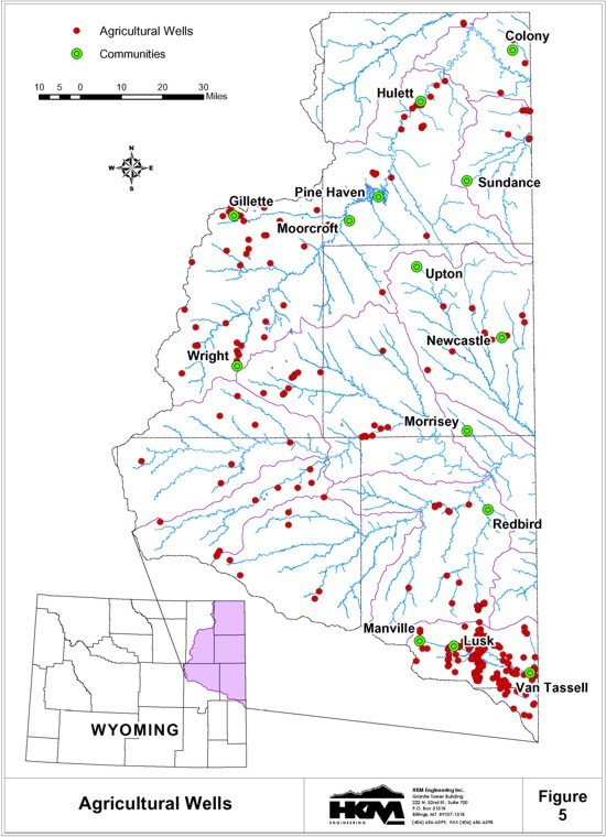
The agricultural well data theme and all other wells data themes developed for this project are based on information contained in the Wyoming State Engineers Office (SEO) ground water database dated December 2000. SEO personnel queried the database for all agricultural wells with a capacity greater than 50 gallons per minute (gpm) and provided HKM with the results. This tabular database was converted to a GIS point data theme with each well being represented by a point positioned at the center of the quarter-quarter section listed in the database. The data fields are described as follows:
| Id | Identification number for well |
| Tns | Township number |
| Rng | Range number |
| Sec | Section number |
| Qtr_Qtr | Quarter-quarter designation |
| Lots | Lot number |
| Survey_Cod | Resurvey code |
| PermitNo | Permit number |
| Status | Permit status |
| Use_ | Type of use |
| Applicant | Name of permit applicant |
| Facility_N | Facility name |
| Priority | Priority date |
| Completion | Completion date |
| Yield_Max_ | Maximum yield in gpm |
| Yield_Actu | Actual yield as reported in the Statement of Completion in gpm |
| Yield_Clai | Claimed yield in gpm |
| Well_Depth | Depth of well in feet |
| Static_Dep | Depth to the static water level in feet |
| Mwbztop__F | Depth to the top of the main water bearing zone in feet |
| Mwbzbot__F | Depth to the bottom of the main water bearing zone in feet |
| HUC_Number | Hydrologic Unit Code Level 4 number |
| Reg_Name | HUC region name |
| Sub_Name | HUC subregion name |
| Acc_Name | HUC accounting name |
| Cat_Name | HUC cataloging name |
| MjrBasin | Major river system name (e.g. Belle Fourche River) |
| USGS_Qd_Id | USGS 7.5" quadrangle index number |
| Quad_Name | USGS 7.5" quadrangle name |
| HKM_Id | HKM quadrangle index number |
| Dgtl_Base | USGS 7.5" quadrangle digital base (Yes, No) |
The locations of the agricultural wells are generally shown on Figure 5.
Storage Reservoirs (GIS polygon shape file, NEMjrRsvr_utm27.shp and NEMjrRsvr_dd27.shp)
The reservoirs GIS data theme was developed based on the high water line as mapped on the vectorized digital base maps derived from the original USGS quadrangle maps. The associated data is listed as follows:
| Resvr_Id | Reservoir identification number. Used to link to "Resvr_ID" in NEMjrRsvrRights.dbf |
| Resvr_Name | Reservoir name |
| Acres | Mapped surface area of reservoir (7.5" scale) |
| HUC_Number | Hydrologic Unit Code Level 4 number |
| Reg_Name | HUC region name |
| Sub_Name | HUC subregion name |
| Acc_Name | HUC accounting name |
| Cat_Name | HUC cataloging name |
| MjrBasin | Major river system name (e.g. Belle Fourche River) |
| USGS_Qd_Id | USGS 7.5" quadrangle index number |
| Quad_Name | USGS 7.5" quadrangle name |
| HKM_Id | HKM quadrangle index number |
| Dgtl_Base | USGS 7.5" quadrangle digital base (Yes, No) |
Storage Reservoir Water Rights (Tabular database, NEMjrRsvrRights.dbf)
| PerNo | Permit number (numerical portion only) |
| PerSfx | Permit suffix |
| Permit_No | Permit number (numeric portion and suffix) |
| Source | Source of surface water supply |
| Facility_N | Facility name |
| Tns | Township number |
| Rng | Range number |
| Sec | Section number |
| Use | Type of use |
| Priority | Priority date |
| Amount | Permitted diversion amount |
| Units | Permitted diversion amount units (gpm, cfs) |
| Applicant | Name of permit applicant |
| Active_Cap | Active storage capacity of reservoir in acre-feet |
| Inactive_C | Inactive storage capacity of reservoir in acre-feet |
| Total_Cap | Total storage capacity of reservoir in acre-feet |
| Resvr_Id | Reservoir id number. Used to link to "Resvr_ID" field in NEMjrRsvr_utm27.shp or NEMjrRsvr_dd27.shp |
SUMMARY OF RESULTS
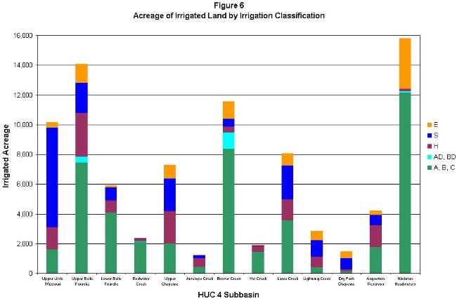
The results of the irrigated lands mapping task are summarized on Tables 1 and 2 and in Figure 6.
|
TABLE 1 SUMMARY OF IRRIGATED LANDS BY IRRIGATION CLASSIFICATION (ACRES) | ||||||||||||||||
| SUBBASIN NAME |
HUC | IRRIGATION CLASSIFICATION | ||||||||||||||
| A | B | C | AB | AC | BC | ABC | TOTAL ABC |
AD | BD | TOTAL AD, BD |
S | H | E | TOTAL | ||
| Upper Little Missouri | 10110201 | 49 | 1,434 | 14 | 106 | 0 | 0 | 0 | 1,603 | 0 | 0 | 0 | 6,712 | 1,486 | 339 | 10,140 |
| Upper Belle Fourche | 10120201 | 2,631 | 4,316 | 8 | 242 | 241 | 0 | 0 | 7,438 | 364 | 39 | 403 | 2,039 | 2,921 | 1,267 | 14,068 |
| Lower Belle Fourche | 10120202 | 2,502 | 989 | 0 | 592 | 0 | 0 | 0 | 4,083 | 0 | 0 | 0 | 883 | 803 | 131 | 5,900 |
| Redwater Creek | 10120203 | 1,405 | 713 | 0 | 0 | 0 | 0 | 0 | 2,118 | 15 | 28 | 43 | 51 | 153 | 12 | 2,377 |
| Upper Cheyenne | 10120103 | 18 | 1,959 | 0 | 0 | 0 | 0 | 0 | 1,977 | 0 | 0 | 0 | 2,194 | 2,187 | 914 | 7,272 |
| Antelope Creek | 10120101 | 0 | 427 | 0 | 0 | 0 | 0 | 0 | 427 | 0 | 0 | 0 | 196 | 576 | 51 | 1,250 |
| Beaver Creek | 10120107 | 396 | 5,739 | 43 | 1,716 | 0 | 320 | 140 | 8,354 | 0 | 1,110 | 1,110 | 508 | 402 | 1,175 | 11,549 |
| Hat Creek | 10120108 | 0 | 1,442 | 0 | 0 | 0 | 0 | 0 | 1,442 | 0 | 0 | 0 | 46 | 381 | 72 | 1,941 |
| Lance Creek | 10120104 | 643 | 2,870 | 43 | 0 | 0 | 0 | 0 | 3,556 | 0 | 0 | 0 | 2,308 | 1,397 | 801 | 8,062 |
| Lightning Creek | 10120105 | 0 | 393 | 0 | 0 | 0 | 0 | 0 | 393 | 0 | 0 | 0 | 1,096 | 722 | 643 | 2,854 |
| Dry Fork Cheyenne | 10120102 | 0 | 119 | 0 | 0 | 0 | 0 | 0 | 119 | 0 | 0 | 0 | 763 | 132 | 454 | 1,468 |
| Angostura Reservoir | 10120106 | 0 | 1,773 | 0 | 0 | 0 | 0 | 0 | 1,773 | 0 | 0 | 0 | 688 | 1,455 | 288 | 4,204 |
| Niobrara Headwaters | 10150002 | 11,147 | 911 | 4 | 0 | 101 | 0 | 0 | 12,163 | 0 | 80 | 80 | 12 | 158 | 3,384 | 15,797 |
| TOTAL | 18,791 | 23,085 | 112 | 2,656 | 342 | 320 | 140 | 45,446 | 379 | 1,257 | 1,636 | 17,496 | 12,773 | 9,531 | 86,882 | |
| TABLE 2 SUMMARY OF IRRIGATED LANDS BY PRIMARY SOURCE OF SUPPLY (ACRES) | ||||
| SUBBASIN NAME | HUC | PRIMARY SOURCE OF WATER SUPPLY | ||
| Ground Water | Surface Water | TOTAL | ||
| Upper Little Missouri | 10110201 | 0 | 10,140 | 10,140 |
| Upper Belle Fourche | 10120201 | 930 | 13,138 | 14,068 |
| Lower Belle Fourche | 10120202 | 186 | 5,714 | 5,900 |
| Redwater Creek | 10120203 | 164 | 2,213 | 2,377 |
| Upper Cheyenne | 10120103 | 127 | 7,145 | 7,272 |
| Antelope Creek | 10120101 | 0 | 1,250 | 1,250 |
| Beaver Creek | 10120107 | 273 | 11,276 | 11,549 |
| Hat Creek | 10120108 | 0 | 1,941 | 1,941 |
| Lance Creek | 10120104 | 667 | 7,395 | 8,062 |
| Lightning Creek | 10120105 | 469 | 2,385 | 2,854 |
| Dry Fork Cheyenne | 10120102 | 32 | 1,436 | 1,468 |
| Angostura Reservoir | 10120106 | 0 | 4,204 | 4,204 |
| Niobrara Headwaters | 10150002 | 14,950 | 847 | 15,797 |
| TOTAL | 17,798 | 69,084 | 86,882 | |
REFERENCES
HKM Engineering Inc.. Agricultural Water Use, Technical Memorandum, Northeast Wyoming River Basins Plan, February 2002. Billings, Montana
HKM Engineering Inc.. Irrigated Crops, Technical Memorandum, Northeast Wyoming River Basins Plan, February 2002. Billings, Montana
Wyoming State Engineers Office, Tabulation of Adjudicated Surface Water Rights of the State of Wyoming, Water Division Number Two, October 1999