Wyoming State Water Plan
Wyoming State Water Plan
Wyoming Water Development Office
6920 Yellowtail Rd
Cheyenne, WY 82002
Phone: 307-777-7626

Wyoming Water Development Office
6920 Yellowtail Rd
Cheyenne, WY 82002
Phone: 307-777-7626


| SUBJECT: |
Appendix G Industrial Water Use |
| PREPARED BY: | HKM Engineering Inc. |
| DATE: | March 2002 |
INTRODUCTION
This technical memorandum provides information on existing water use for the major industrial water users in the Northeast Wyoming River Basins.
The industrial users examined include:
Pacific Power Corp.
Black Hills Power Company
North American Power Group
Oil & Gas Production
Coal Mining
Coalbed Methane Production
Miscellaneous
METHODOLOGY
Most of the information reported here was collected directly through telephone or personal interviews with the individual water users, as well as interviews with the Coalbed Methane Coordination Coalition, the Wyoming Oil & Gas Conservation Commission (OGCC), and the U.S. Bureau of Land Management. In the case of Coalbed Methane Production, additional data interpretation is required.
All coalbed methane extraction is dependent on lowering the pressure over the coal seam through reducing the column of water in the coal aquifer. The water produced from these wells is not used consumptively . at least initially. The water is simply transferred from groundwater to surface water status. The water can be stored in reservoirs where it can evaporate or percolate into shallow aquifers; or discharge into nearby drainages. Stock, wildlife, and vegetation consume some of the water along the watercourses. If the water is discharged into a drainage directly, a significant portion of the discharge water also percolates into the ground or evaporates along the watercourse. Because none of the well discharge monitoring as reported in the Oil and Gas Conservation Commission's (OGCC) databases extends downstream, potential consumptive uses cannot be effectively quantified. Nevertheless, the OGCC database contains the most complete information available on discharges from CBM wells.
HKM downloaded the CBM water discharge database from the OGCC Internet site as two Microsoft Excel spreadsheets (dated 1/28/2002, downloaded 2/15/2002), then used a combination of relational database, spreadsheet, and GIS software tools to estimate the cumulative discharge from all wells in the Northeast Wyoming River Basins and each of the subbasins within it.
The OGCC data set is striking for being the best source of data on CBM produced water available, but it isn't perfect. The OGCC data set includes production figures for 10,995 fewer wells in Wyoming than it has individual identity codes for. According to OGCC staff, this is due to several factors: expired wells, temporarily abandoned ones, wells awaiting approval, shut-in wells, and wells for which operators refuse to submit data. Unfortunately, the OGCC has no way of gauging the magnitude of the last factor.
The numbers reported here are generated from the OGCC's month-by-month reckoning. In the case of the year 2001 totals, all months for the year 2001 are totaled for each production point. (Some wells have multiple production points, being developed in multiple coal seams or aquifers.) To generate the cumulative sum for all wells in the basin for their entire production period, all production associated with each unique identifier was totaled. The well locations associated with these totals are used to create a theme in a GIS. The resulting GIS allows users to query each subbasin by Hydrologic Unit Code (HUC) to understand how many barrels of water are being produced by how many wells within the subbasin during the year 2001 and during the history of CBM development in the basin.
CONCLUSIONS
Industrial Surface Water Use
Industrial use of surface water is very limited in the Northeast Wyoming Basins. The only major industrial user identified that has any significant surface water use is Black Hills Power, with a surface water use of approximately 272 gpm, of which the majority is supplied as treated wastewater effluent from the city of Gillette. In addition to Black Hills Power, several other surface water rights holders were identified; but there is no information as to whether these rights are being used or for what purpose. Table 1 lists all industrial surface water rights (all in reservoirs) on record, including their priority date, amount, and location.
Table 1: Northeast River Basin industrial surface water permits
| Permit | Priority Date | Vol. (af) |
Appropriator | Tributary | Location (S-T-R) |
|---|---|---|---|---|---|
| 8626R | 06-27-1983 | 194.6 | Black Hills Power & Light | EAST BRANCH POISON CREEK, Tributary Poison Creek, Tributary Beaver Creek | 15-46-063 |
| 6046R | 07-15-1953 | 172.7 | Harry Berger | LITTLE MISSOURI RIVER, Tributary Missouri River | 18-53-067 |
| 7150R | 05-02-1963 | 14.7 | Berton David Fortner | DRY DONKEY CREEK, Tributary Donkey Creek | 24-49-071 |
| 7368R | 12-03-1970 | 8.4 | Robert Deaver | OUSMUS DRAW, Tributary Dry Creek (9-46-71) | 14-46-070 |
| 8924R | 08-13-1984 | 3.19 | Lawence Materi | WOLF DRAW, Tributary Little Soda or Box Elder Creek | 14-47-066 |
Industrial Groundwater Use
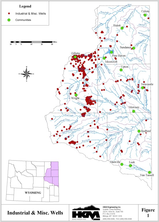
The majority of industrial water use in the basin is attributed to groundwater sources. The largest permitted groundwater rights are identified in Table 2. A more complete inventory of the permitted industrial use wells is provided in the Industrial Groundwater wells data theme developed for this study and generally shown on Figure 1. The oil and gas (O&G) production and coal bed methane (CBM) industries are the major groundwater producers in the basin. But in the case of O&G producers, they tend to consumptively use large amounts of water through "water-flood" or injection practices because water is transferred from a water aquifer into an oil or gas aquifer, degrading the water quality. An inventory of the permitted industrial use wells is provided in the Industrial Groundwater wells data theme developed for this study and generally shown on Figure 1.
Table 2: Northeast River Basin's 10 largest industrial groundwater permits
| Permit | Priority Date | Flow | Appropriator | Tributary | Application |
|---|---|---|---|---|---|
| P 46982 | 09-22-1978 | 1100 cfs | Black Hills Power & Light | SE SW 10-46-63 | Cooling water and makeup water for scrubbers for 100MW addition for Osage; reservoir supply for towers in town of Osage |
| P 11005 | 10-27-1971 | 400 gpm | Inexco Oil Company | NW NW 8-45-70 | Water flood application to enhance oil production |
| SC 436 | 04-11-1941 | 350 gpm | Black Hills Power & Light | NE SW 10-46-63 | Electric generation |
| P 11012 | 10-27-1971 | 350 gpm | Inexco Oil Company | NW NW 7-44-70 | Water flood application to enhance oil production |
| P 9258 | 05-24-1971 | 415 gpm | Inexco Oil Company | SE NE 34-46-71 | Water flood application to enhance oil production |
| P 11011 | 10-27-1971 | 300 gpm | Inexco Oil Company | NW NW 12-44-71 | Water flood application to enhance oil production |
| P 11004 | 10-27-1971 | 275 gpm | Inexco Oil Company | SE NE 18-45-70 | Water flood application to enhance oil production |
| P 11007 | 10-27-1971 | 250 gpm | Inexco Oil Company | NE SE 14-45-71 | Water flood application to enhance oil production |
| P 11009 | 10-27-1971 | 200 gpm | Inexco Oil Company | NW NW 36-45-71 | Water flood application to enhance oil production |
| WR 143 | 07-18-1952 | 200 gpm | Black Hills Power & Light | SE NW 15-46-63 | Electric generation, gen. water supply, drinking, cooling, sanitation |
Electric Power Generation
The major consumptive user of groundwater in the basin appears to be the power generation industry. The facilities operated by Black Hills Power and Pacific Power (with the exception of the Osage facility) have air-cooled condensers, greatly reducing their water consumption. Water use at these facilities is attributed mostly to makeup water for the boilers, with additional consumption for washdown and domestic uses. The Osage facility is water-cooled and uses a larger quantity of water, but this plant is slated for shutdown in the year 2010. The North American Power Group's Two Elk Facility is scheduled to be completed and in operation in 2003, with two additional facilities being constructed in the future. These facilities will all be served by groundwater sources, with the option of being supplemented with CBM produced water.
Oil & Gas Production
Based on information from the Oil & Gas Commission, year 2000 net use of water amounted to approximately 209 acre-feet (see tables 3 and 4). The Wyoming State Engineer's Office considers injection for water-flood purposes "consumptive use" because it transfers water (whatever the source) to an aquifer that degrades that water quality. Unfortunately, overall conventional O&G consumptive water use cannot be tracked with any accuracy. The current structure of data collection doesn't require tracking of actual discharges to the surface from produced water volumes, and water used for injection comes from produced water and wells drilled specifically to provide injection volumes. There are approximately 240 secondary recovery-specific water wells in the Powder/Tongue and Northeast Basins combined.
Table 3: Conventional O&G
Produced Water, year 2000
| Subbasin (by HUC) | Volume for year (bbl) | Number of wells |
|---|---|---|
| 10110201 | 17,017,669 | 71 |
| 10120101 | 382,765 | 183 |
| 10120102 | 31,360 | 32 |
| 10120103 | 2,168,990 | 614 |
| 10120104 | 7,376,332 | 68 |
| 10120105 | 591,580 | 490 |
| 10120106 | 215,179 | 65 |
| 10120107 | 1,712,940 | 375 |
| 10120108 | 322,230 | 2 |
| 10120201 | 49,055,787 | 978 |
| 10120202 | 0 | 0 |
| 10120203 | 0 | 0 |
| 10150002 | 0 | 0 |
| TOTAL | 78,874,832 | 2,878 |
Table 4: Conventional Oil & Gas injected
water volumes, year 2000
| Subbasin (by HUC) |
Volume for year (bbl) |
Number of wells |
|---|---|---|
| 10110201 | 7,912,422 | 37 |
| 10120101 | 483,530 | 23 |
| 10120102 | 9,073,648 | 12 |
| 10120103 | 1,496,728 | 33 |
| 10120104 | 1,904,140 | 18 |
| 10120105 | 1,884,630 | 24 |
| 10120106 | 257,327 | 1 |
| 10120107 | 1,832,071 | 355 |
| 10120108 | 322,230 | 1 |
| 10120201 | 55,329,068 | 623 |
| 10120202 | 0 | 0 |
| 10120203 | 0 | 0 |
| 10150002 | 0 | 0 |
| TOTAL | 80,495,794 | 1,127 |
Coal Mining
Water usage (consumption) in the coal mining industry is mainly attributed to dust abatement, with lesser amounts used for equipment wash-down and domestic purposes. Water for these uses is obtained from pit dewatering wells, pit sumps, and captured surface runoff. Excess water is discharged at various permitted points that vary from year to year due to mine progress. Water use can vary significantly between mines, and annually for any particular mine. These variations are attributed to a number of variables, including the characteristics and location of the mine and water bearing formation, precipitation, and mine progress (distance to active mine area from processing area). Since water use is not a function of coal production, no correlation can be made between annual coal production and water use. (See Table 7 for mine usage and production figures.)
The SEO's Groundwater Division maintains a record of coal mine water usage, but as of this writing, it was not complete or updated.
Coalbed Methane
There is little direct consumptive use in the CBM industry. The majority of water is produced water from the coal seam dewatering process. Nevertheless, a significant portion of the discharged water is estimated to be lost in conveyance along existing drainages. Based on information from the Coalbed Methane Coordination Coalition, as a general rule, there are approximately 105 gallons of water produced per 1000 CF of methane gas. This value varies from well to well as a function of the coal seam and the age of the well, with water production generally decreasing with the age of the well.
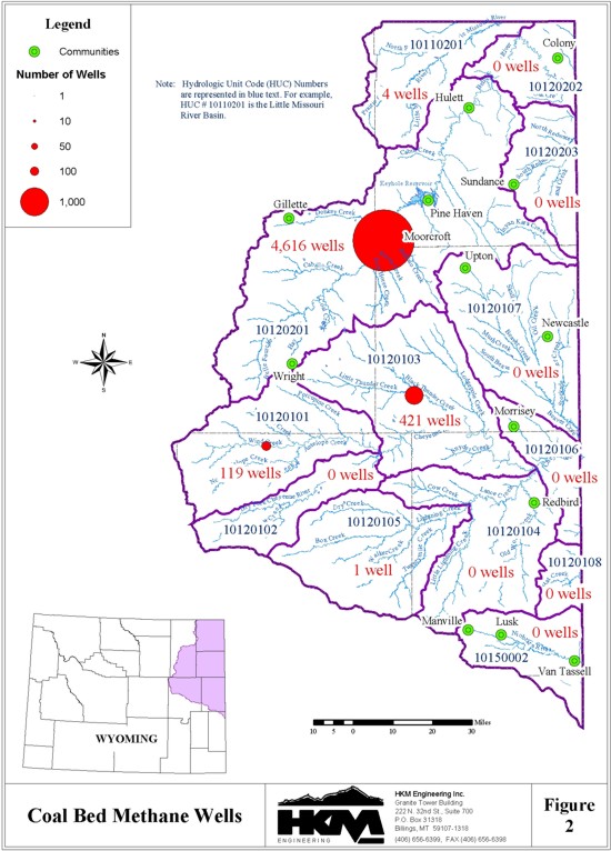
Wyoming Oil & Gas Conservation Commission (OGCC) records (updated Jan. 28, 2002) show 5,161 CBM wells in the Northeast Wyoming River Basins, with a total water discharge of 273.8 million barrels of water during the year 2001 (just less than 35,600 acre-feet in that year). Because OGCC's data collection activities go back to the 1970s, their records of cumulative CBM activity essentially cover the history of the industry's activity in the basin. Cumulatively, the Northeast Wyoming River Basins has produced 773.5 million barrels of water from CBM activity (or just more than 99,704 acre-feet of water).
The following tables summarize the year 2001 and cumulative CBM produced water discharges in the Northeast Wyoming River Basins by subbasin (designated by Hydrologic Unit Code, or HUC, found on Figure 2).
Table 5: Year 2001 CBM Produced Water,
Northeast Wyoming River Basins
| HUC | prod'n pts | 2001 Total | |
|---|---|---|---|
| BBL. | a-f | ||
| 10110201 | 4 | 0 | 0.00 |
| 10120101 | 120 | 6,743,715 | 869.22 |
| 10120102 | 0 | 0 | 0.00 |
| 10120103 | 417 | 43,591,113 | 5,618.62 |
| 10120104 | 0 | 0 | 0.00 |
| 10120105 | 1 | 0 | 0.00 |
| 10120106 | 0 | 0 | 0.00 |
| 10120107 | 0 | 0 | 0.00 |
| 10120108 | 0 | 0 | 0.00 |
| 10120201 | 4,631 | 223,503,212 | 28,808.18 |
| 10120202 | 0 | 0 | 0.00 |
| 10120203 | 0 | 0 | 0.00 |
| 10150002 | 0 | 0 | 0.00 |
| TOTAL | 5,173 | 273,838,040 | 35,296.03 |
Table 6: Cumulative CBM Produced Water,
Northeast Wyoming River Basins
| HUC | # wells | 2001 Total | |
|---|---|---|---|
| BBL. | a-f | ||
| 10110201 | 4 | 177,365 | 22.86 |
| 10120101 | 119 | 11,593,459 | 1,494.32 |
| 10120102 | 0 | 0 | 0.00 |
| 10120103 | 421 | 110,396,419 | 14,229.41 |
| 10120104 | 0 | 0 | 0.00 |
| 10120105 | 1 | 0 | 0.00 |
| 10120106 | 0 | 0 | 0.00 |
| 10120107 | 0 | 0 | 0.00 |
| 10120108 | 0 | 0 | 0.00 |
| 10120201 | 4,616 | 651,372,532 | 83,957.88 |
| 10120202 | 0 | 0 | 0.00 |
| 10120203 | 0 | 0 | 0.00 |
| 10150002 | 0 | 0 | 0.00 |
| TOTAL | 5,161 | 773,539,775 | 99,704.48 |
Note: One well may have multiple production points, having been developed in several coal seams or aquifers. This is how the number of production points in Table 5 exceeds the number of wells in Table 6.
The numbers summarized in these tables do not indicate what happens to the water once it is transferred from groundwater to surface water by CBM wells. No agency monitors the fate of CBM water once it leaves a wellhead. Information received through various interviews indicates that the majority of the discharge water is allowed to flow into existing drainages, though some is stored in small reservoirs and disposed of through infiltration or evaporation. A small amount may also be disposed of through land application (irrigation); but as noted previously there is little information with respect to disposal. A significant portion of discharged CBM water is likely lost in conveyance. Coalbed Methane Coordination Coalition coordinator Mickey Steward maintains that the information available from monitoring wells maintained by the various coal mines around Gillette provide an opportunity to understand how much CBM discharge water enters shallow, alluvial aquifers. This research has yet to be undertaken.
Other information on CBM wells, like locations and densities, can be found in the GIS data theme developed for this study and as generally shown on Figure 2.
Miscellaneous
The Wyoming Refining Company facility in Newcastle consumes approximately 250 gpm (131,400,000 gal/yr.) on a constant basis for its refining operation. The town of Newcastle provides the majority of the water from its water treatment plant, with only a small amount obtained from a single well completed in the Madison formation and several others in shallower aquifers.
Table 7 is a summary of the industrial groundwater users identified, with estimated annual water usage and discharge.
Table 7: Largest Industrial Water Usage
| Company | Industry | Location | Source | Annual Use (gal/yr) |
Annual Discharge (gal/yr) |
|---|---|---|---|---|---|
| Black Hills Power / Pacific Power | Electric Generation | Wyodak Plant | Groundwater Surface Water |
147,168,000 136,393,200 |
54,750,000 (storm runoff) |
| Black Hills Power | Electric Generation | Osage Plant | Groundwater | 416,300,000 | 131,400,000 |
| North American Power Group | Electric Generation | Two Elk Plant | Groundwater | 262,800,000* | -0-* |
| Thunder Basin Coal Company | Coal Mining | Black Thunder Mine | Groundwater/ Surface Runoff |
234,393,000 | 865,500,000 |
| Kennecott Energy | Coal Mining | Antelope Mine | Groundwater/ Surface Runoff |
59,445,000 | 47,027,600 |
| Kennecott Energy | Coal Mining | Cadero-Rojo Complex | Groundwater/ Surface Runoff |
105,336,000 | 62,040,000 |
| Kennecott Energy | Coal Mining | Jacobs Ranch | Groundwater/ Surface Runoff |
261,888,000 | 17,952,000 |
| Powder River Coal Company | Coal Mining | Caballo Mine | Groundwater | 204,244,200 | -0- |
| Wyoming Refining Company | Petroleum Refining |
Newcastle | City of Newcastle/ Groundwater |
131,400,000 | -0- |
REFERENCES
Beals, Paul, natural resource specialist, U.S. Bureau of Land Management, telephone interview, 1 June 2001.
Farrell, John, manager, and Jensen, John, environmental manager, Howell Petroleum Corp., telephone interview, 24 May 2001.
Fisher, Wayne, Pioneer Oil Company, telephone interview, 23 May 2001.
Green, Bob, manager of regulatory affairs, Kennecott Energy Corp., telephone interview, 30 May 2001.
Harmon, Tommy, field manager, Exxon/Mobil Corp., telephone interview, 30 May 2001.
Haverner, Pat, vice-president of refining, Wyoming Refining Company, telephone interview, 31 May 2001.
Henshaw, Bernadette, environmental engineer, Pacific Power Corporation, telephone interview, 30 May 2001.
Homisted, Mitch, Ensign EOG Operating Company, telephone interview, 30 May 2001.
Hutchinson, Wendy, regulatory affairs manager, ARCH Black Thunder Coal Mine, telephone interview, 24 May 2001.
Hutton, Dave, MIS, Wyoming Oil and Gas Conservation Commission, telephone interview, 19 June 2001.
Kane, Kevin, environmental manager, Citation Oil Company, telephone interview, 31 May 2001.
Mock, Dan, operator, Pacific Power Corp.'s Wyodak #1 power plant, telephone interview, 20 June 2001.
Money, Kerry, Lake DeSmet Energy Company, telephone interview, 22 May 2001.
Mueller, Steve, environmental manager, Black Hills Power Company, telephone interview, 21 May 2001.
Murphy, Ray, environmental manager, Barrett Resources, telephone interview, 21 May 2001.
Olson, Joe, environmental manager, Pennaco Energy Corporation, telephone interview, 25 May 2001.
Rexroat, Scott, environmental engineer, Caballo Mine, Powder River Mining Company, telephone interview, 21 May 2001.
Roeper, Dennis, plant manager, Black Hills Power/Osage Plant, telephone interview, 31 May 2001.
Ruffato, Mike, North American Power Group, telephone interview, 25 May 2001.
Sigmund, Lee, district manager, CMS Energy, telephone interview, 25 May 2001.
Steward, Mickey, coalbed methane coordinator, Coalbed Methane Coordination Coalition, telephone interview, 23 May 2001.
Steward, Mickey, coalbed methane coordinator, Coalbed Methane Coordination Coalition, personal interview, 26 June 2001.
Trout, Jerry, owner, J.M. Huber Company, telephone interview, 24 May 2001.
Wiley, Tony, water permit manager, Yates Petroleum, telephone interview, 21 May 2001.
Williams, Bruce, vice-president of operations, Fidelity Exploration Company, telephone interview, 23 May 2001.
Industrial Summary
Entity: Osage Plant/Black Hills Power
Industry: Power Generation
Operation: The Osage Plant is located between Newcastle and Moorcroft. The plant was built between 1948 and 1952, and is permitted until 2010, which is the design life of the plant. There are no plans to re- permit, or replace the plant. The plant is water-cooled with three cooling towers and produces 33MW.
Water use is for cooling, make-up water and a slurry system for fly ash.
Water Source: The water source is three groundwater wells that are completed in the Madison formation.
Water Supply: Water production for the three supply wells is as follows:
Well #1: 300 gpm, year aroundThe wells are on-site and feed into a public storage reservoir that is maintained for recreational use.
Well #2: 1,825,000 gallons/month (25,000 gal/month for domestic)
Well #3: 300 gpm, Nov. to April, and 600 gpm, May to October
Discharge System: The plant has a discharge of 250 gpm, 100 gpm for cooling water discharge and 150 gpm for ash disposal. Discharge is to Poison Creek and supplied to ranchers.
Estimated Annual Water Usage: Based on the supply well information obtained from company personnel, the total annual water usage is approximately 416,300,000 gallons/year, of which 300,000 gallons is for domestic use.
Industrial Summary
Entity: Two Elk Power Plant/North American Power Group
Industry: Power Generation
Operation: The Two Elk Power Plant is located southeast of Wright. The plant is under construction and it projected to go online in 2003. Two additional plants are presently in the planning stage. They are summarized below:
   Facility	   Power Production	  Status	   Water Use
   Two Elk	       300  MW	   Under Construction	 500 gpm (ave.)
   Two Elk #2	       300  MW	     Planning Stage	 500 gpm (est.)
   Middle Bear	       300+ MW	     Planning Stage	 500 gpm (est.)
   Total ground water usage	                        1500 gpm (ave.)
Water consumption is primarily for cooling make-up water. These power plants will all use dry cooling, which uses about one tenth of the normal demand for a power generation facility. This is used for make-up water in essentially a closed radiator type system.
Water Source: Groundwater, with the potential of supplementing with CBM discharge water in the future.
Water Supply: The Two Elk Plant will use 10 permitted deep wells for its water supply. The Owner is investigating the potential for supplementing its groundwater sources with coal bed methane discharge water in the future. However, it is still unknown if there will be a consistent supply for the 30-50 year lifetime of the plant.
Discharge System: The facilities produce no discharge.
Estimated Annual Water Usage: Based on information obtained from an interview with company personnel, it is estimated that the Two Elk Plant will use approximately 800-acre ft. of groundwater annually. The two additional plants that are in the planning stages are each expected to have a similar water use.
Industrial Summary
Entity: Kennecott Energy (Antelope Mine)
Industry: Coal Mining
Operation: The Antelope Mine, located 60 miles N. of Wright, produces approximately 23 million tons of coal annually. The major water use on site is dust control, with the secondary uses including domestic and plant washdown.
Water Source: Ground Water and Impounded Runoff
Water Supply: Water for domestic use and plant washdown is supplied by on-site potable wells. Water provided for dust control is obtained from the pit sumps, pit dewatering wells and impounded runoff.
Discharge System: Excess water from the pit sumps and dewatering wells is discharged from the site at a number of permitted sites (20 pond sites and 5 dewatering well sites). Based on information obtained from an interview with company personnel, total discharge for the Year 2000 was approximately 47,027,600 gallons. All discharges from the site are to Antelope Creek, and ultimately the Cheyenne River.
Estimated Annual Water Use: For the year 2000, total water consumption was approximately 19,815,000 gallons from groundwater and 39,630,000 gallons from impounded runoff. Approximately 95% of water usage is for dust control and abatement.
Industrial Summary
Entity: Kennecott Energy (Cadero-Rojo Complex)
Industry: Coal Mining
Operation: The Cadero-Rojo Complex, located 20 miles SE of Gillette, produces approximately 38.6 million tons of coal annually. The major water use on site is dust control, with the secondary uses including domestic and plant washdown.
Water Source: Ground Water and Impounded Runoff
Water Supply: Water for domestic use and plant washdown is supplied by on-site potable wells. Water provided for dust control is obtained from the pit sumps and pit dewatering wells and impounded runoff.
Discharge System: Excess water from the pit sumps and dewatering wells is discharged from the site at various permitted sites. Based on information obtained from an interview with company personnel, total discharge for the year 2000 was approximately 62,040,000 gallons. All discharges from the site are to the Belle Fourche River.
Estimated Annual Water Use: For the year 2000, total water consumption was approximately 101,640,000 gallons from groundwater and 3,696,000 gallons from impounded runoff. Approximately 95% of water usage is for dust control and abatement.
Industrial Summary
Entity: Kennecott Energy (Jacobs Ranch Mine)
Industry: Coal Mining
Operation: The Jacobs Ranch Mine, located 12 miles E. of Wright, produces approximately 28.3 million tons of coal annually. The major water use on site is dust control, with the secondary uses including domestic and plant washdown.
Water Source: Ground Water and Impounded Runoff
Water Supply: Water for domestic use and plant washdown is supplied by on-site potable wells. Coal mines typically use pit water, but Jacobs Ranch is a dry mine. Water provided for dust control is obtained from dewatering wells and impounded runoff.
Discharge System: Excess water from the dewatering wells is discharged from the site under Permit No. WY-0024091. In addition to the excess dewatering flows, surface runoff is picked up from precipitation and adjacent coal bed methane wells and discharged from the site. Based on information obtained from an interview with company personnel, total discharge for the year 2000 was approximately 17,952,000 gallons. All discharges from the site are to the Little Thunder River, which is a tributary to the Cheyenne River.
Estimated Annual Water Use: For the year 2000, total water consumption was approximately 245,784,000 gallons from groundwater and 16,104,000 gallons from impounded runoff. Approximately 95% of water usage is for dust control.
Industrial Summary
Entity: Powder River Coal (Caballo Mine)
Industry: Coal Mining
Operation: The Caballo Mine, located just south of Gillette, produces approximately 26 million tons of coal annually. The major water use on site is dust control, with the secondary uses including domestic and plant washdown.
Water Source: Ground Water
Water Supply: Water for domestic and plant washdown is supplied by one (1) potable well. Water for dust control is supplied by five (5) pit sump and dewatering wells.
Discharge System: This is essentially a non-discharge facility, with occasional discharges occurring in stormwater situations. Any discharges that occur are to tributaries of Caballo Creek.
Estimated Annual Water Usage: For the year 2000, total water production from the pit sumps and pit-dewatering wells was approximately 165,092,700 gallons. Total production from the potable well was 39,151,500 gallons.
Industrial Summary
Entity: Thunder Basin Coal Company (Black Thunder Mine)
Industry: Coal Mining
Operation: The Black Thunder Mine, located approximately 12 miles SE of Wright, produces approximately 60 million tons of coal annually. The major water use on site is dust control, with the secondary uses including domestic, plant washdown, and fire suppression.
Water Source: Ground Water
Water Supply: Water for domestic, plant washdown, and fire suppression was supplied by three (3) potable wells, which as of 2001 has been reduced to two wells. Water provided for dust control is obtained from the pit sumps and pit dewatering wells.
Discharge System: Excess water from the pit sumps and dewatering wells is discharged from the site under Permit No. WY-0024091. In addition to the excess pit and dewatering flows, surface runoff is picked up from precipitation and adjacent coal bed methane wells and discharged from the site. All discharges from the site are to Little Thunder Creek, and ultimately the Cheyenne River.
Estimated Annual Water Use: For the year 2000, total water production from the pit sumps and dewatering wells was approximately 175,141,000 gallons. Additionally, 325,080,000 gallons of water was supplied by the North Prong Pump Site No. 1, which includes water from the West Pit dewatering wells (56,393,007 gallons), and excess surface runoff due to precipitation and coal bed methane production. Approximately 178,000,000 gallons of water was applied to the road for dust control. This amount is similar to that used in 1999, which was also a dry year, but could be expected to decrease in wet years. Potable water usage for the year 2000 was 28,881,000 gallons
Based on discharge monitoring reports, the site discharged approximately 865,500,000 gallons for the year 2000.
Industrial Summary
Entity: Black Hills Power Company/Pacific Power
Industry: Power Generation
Operation: The single site seven miles east of Gillette contains several power plants, some of which are in construction, one of which is in the planning stages. They are summarized below:
   Facility	  Power Production	    Status	           Water Use
    Wyodak 1	       360 MW	           Operating	         260 gpm
    Neal Simpson #1	20 MW	           Operating	    groundwater: 140 gpm
    Neal Simpson #2	80 MW	           Operating	    groundwater: 140 gpm
    WyGen #1	        90 MW	       Under construction	future: groundwater
    WyGen #2	       500 MW	     In permitting process	future: groundwater
    Gas turbine #1	40 MW	           Operating	           0
    Gas Turbine #2	40 MW	           Operating	           0
    Office	                                                  12 gpm
    Total surface water usage	                                 272 gpm
Note: This total is reduced in winter by approximately 50 gpm.
At present, all plants depend on air-cooled condensers for coal-fired plants that reduce water needs, though at least one plant began operation partly water-cooled.
Water consumption is limited to make-up water (water replacing steam-generation loss through the boiler), scrubber water used to mix the lime and fly ash in the scrubbers, service water used to wet fly ash before it is hauled to the landfill, and domestic water for drinking, sewage, and lawn irrigation.
Water Source: Groundwater and treated municipal effluent
Water Supply: Wells provide the 12 gpm domestic use and the Neal Simpson 1 and 2 plant consumption. The City of Gillette.s sewage effluent (itself a combination of ground- and stormwaters) provides the remainder.
Discharge System: Normally, the facilities produce no discharge. Spring storms overflow the Pacific Corp. ash ponds, discharging enough water into Donkey Creek to bring the daily average to 150,000 gallons per day.
Estimated Annual Water Usage:
Gillette sewage effluent: For an estimated annual use, assume winter operations occupy one-quarter of the year: (272 x 0.75 + 222 x 0.25)
x 365 x 24 x 60 = approx. 136 million gallons = approx. 18.2 million cu. ft. = approx. 419 acre-feet per year.
Groundwater: 280 x 365 x 24 x 60 = approx. 147 million gallons = approx. 19.7 million cu. ft. = approx. 452 acre-feet per year.
Industrial Summary
Entity: Wyoming Refining Company
Industry: Petroleum Refinery
Operation: The Wyoming Refining facility is located in Newcastle. The facility currently is refining 12,500 barrels/day, but the average production over the past year was 11,000 barrels/day. The refinery plans to increase production over the next ten years, which would require a corresponding increase in water consumption of 20%, and increase production by 50% over the next 30 years with a 25% increase in water consumption. Water is primarily used for cooling streams in the heat exchangers, with some small amount being used to mix with the oil during the refining process.
Water Source: The city of Newcastle provides the majority of the water demand, with some water being obtained from groundwater wells completed in the Madison formation. No information was obtained as to the amount obtained from each of the two sources.
Water Supply: The facility uses 250 gpm on a constant basis. The facility has had some problems with water supply over the past six months as a result of expansion of the facility; however, installation of a new booster pump for the city-supplied water is expected to solve that problem.
Discharge System: Based on information we received, this is a non-discharging facility.
Estimated Annual Water Usage: Based on the water use information received from company personnel, the annual water usage for the facility is approximately 131,400,000 gallons/year.