Wyoming State Water Plan
Wyoming State Water Plan
Wyoming Water Development Office
6920 Yellowtail Rd
Cheyenne, WY 82002
Phone: 307-777-7626

Wyoming Water Development Office
6920 Yellowtail Rd
Cheyenne, WY 82002
Phone: 307-777-7626


Northeast Wyoming River Basins Plan
Prepared for:
Wyoming Water Development Commission
Basin Planning ProgramPrepared by:
HKM Engineering Inc.
Lord Consulting
Watts and AssociatesFebruary 2002
Project Scope
The Northeast Wyoming River Basins Plan document is one of four River Basin Plans thus far completed by the Wyoming Water Development Commission as authorized by the Wyoming Legislature in 1999. The plans for the Bear River Basin and Green River Basin were completed in 2001, and the plan for the Powder/Tongue River Basin is being completed concurrently with the Northeast Wyoming River Basins Plan. The Wind/Big Horn River Basin and the Snake/Salt River Basin plans were initiated in 2002 and the plan for the North Platte River will commence in the near future. It is the express desire of the program to revisit and update the basin planning documents every five years.
This planning document presents current and projected future uses of water in Wyoming's Northeast Wyoming River Basins. Uses inventoried and analyzed in this plan include agricultural, municipal, industrial, environmental, and recreational. Surface and ground water uses are both described, as is overall water quality. Given current uses, the availability of surface water and ground water to meet estimated future requirements is analyzed. The current institutional and legal framework of water development and management is presented.
The primary products of this planning study are technical memoranda prepared for the large number of topics addressed in the plan. These memoranda provide detailed descriptions of the data collected, source references, analyses performed, tools developed, and the results of each investigation required to fully explore the water resources within the planning area. The intent of this Executive Summary, and the associated Final Report, is to describe the planning study in sufficient detail for the reader to gain a general understanding of the investigations that were performed and the results of those investigations. For detailed information on a specific topic the reader is directed to the technical memorandum prepared for that topic.
Basin Description
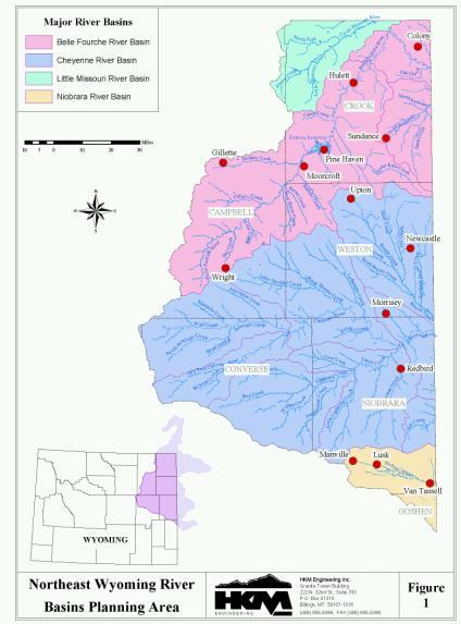
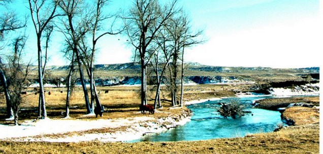
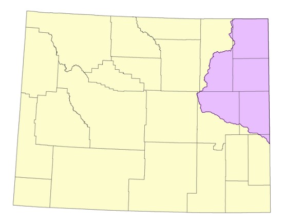
The study area of the Northeast Wyoming River Basins Plan includes the drainages of the Little Missouri River, Belle Fourche River, Cheyenne River, and Niobrara River. These river basins encompass all or part of Campbell, Crook, Weston, Converse, and Niobrara counties as well as minor parts of Natrona and Goshen counties in northeast Wyoming. The planning area is shown on Figure 1.
Climate throughout the Basin varies, but generally follows the pattern of a high desert region. Annual precipitation in the range of 13 to 15 inches is the norm for the majority of the planning area.
The major rivers and streams in the study area include the following:
Water Law and Interstate Compacts
The Wyoming constitution establishes water in the state to be the property of the state. Consequently, all development and management of water resources in Wyoming is governed by the water laws embodied in the Constitution and Statutes. These water laws are recognized as inviolate in the river basin planning program.
Interstate compacts controling the development and use of water in the study area include the Belle Fourche River Compact of 1943 and the Upper Niobrara River Compact of 1962. Compacts have also been developed for the Cheyenne River and the Little Missouri River, but these agreements have yet to be fully ratified.
The Belle Fourche River Compact of 1943 divides the water between Wyoming and South Dakota. The compact recognizes all rights in Wyoming existing as of the date of the compact, and permits Wyoming unlimited use for stock water reservoirs not exceeding twenty acre-feet in capacity. Wyoming is allowed to deplete the flow of the Belle Fourche River under the conditions existing as of the date of the Compact by an additional 10%. No reservoir constructed subsequent to the date of the compact solely to utilize the water allocated to Wyoming shall have a capacity greater than 1,000 acre-feet.
The Upper Niobrara River Compact of 1962 between Wyoming and Nebraska provides that stock water reservoirs not larger than twenty acre-feet capacity in Wyoming shall not be restricted. No restrictions are placed on diversion or storage of water in Wyoming except on the main stem of the Niobrara River east of Range 62 West and on Van Tassel Creek south of Section 27, Township 32 North, Range 60 West. In this area direct diversions are regulated on an interstate priority basis with lands in Nebraska west of Range 55 West, and storage reservoirs with priority dates prior to August 1, 1957, may store water only during the period of October 1 to June 1, while storage reservoirs with priority dates after August 1, 1957, may store a maximum of 500 acre-feet in any water year with dates of storage limited to the period of October 1 to May 1. Ground water development is recognized to be a significant factor and the compact provides for investigation of this resource and possible apportionment at a later date.
Agricultural Water Use
Irrigated agriculture in the planning area is primarily associated with forage production for the livestock industry. Ranchers depend on irrigated cropland to provide winter feed and summer grazing for their stock. Alfalfa, grass hay, and pasture grass are the dominant crops grown in the planning area. Lesser amounts of small grains and corn are also produced. In total, 77,350 acres of land are actively irrigated in the planning area. Of this total, 13,036 acres are served from ground water and the remainder is served from surface water supplies.
The depletion of water by irrigation is primarily dependent on the number of acres irrigated, the crop water demands, and the amount of water available to meet these demands. Surface water depletions for wet, normal, and dry years total 71,000 acre-feet, 69,000 acre-feet, and 65,000 acre-feet respectively. Ground water depletions for wet, normal, and dry years total 17,000 acre- feet, 17,000 acre-feet, and 11,000 acre-feet respectively.
Municipal and Domestic Water Use
There are thirty-three public water supply entities in the planning area, consisting of incorporated municipalities, districts, and privately owned water systems. These entities consume approximately 9,100 acre-feet of ground water per year. Domestic use is also satisfied by ground water and is on the order of 2,100 to 3,600 acre-feet per year.
Industrial Water Use
Industrial water use in the Northeast Wyoming River Basins consists of conventional oil and gas production, coalbed methane development, electric power generation, coal mining, and oil refining. These uses deplete approximately 50,700 acre-feet of ground water per year.
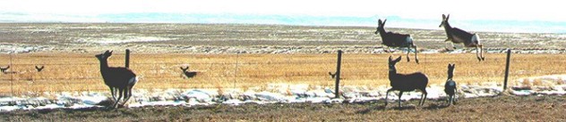
Recreational Water Use
Recreational uses associated with the water resources of the Northeast Wyoming River Basins include boating, fishing, and waterfowl hunting. Although these uses are generally non- consumptive, water-based recreation is enhanced through minimum flow releases from reservoirs, minimum pool levels maintained in reservoirs, and instream flow water rights established on streams. Keyhole Reservoir, the largest standing water recreation attraction in the Northeast Wyoming River Basins, supports skiing, fishing, swimming, boating, and camping.
Environmental Water Use
Environmental uses of water in the Northeast Wyoming River Basins are largely non- consumptive. Environmental use topics addressed in this planning study include water administration (minimum flow releases, minimum pool maintenance, and instream flow water rights), environmental concerns associated with water produced by coal bed methane development, and wetland mapping. Concerns expressed by environmental organizations are also presented in the basin plan.
Reservoir Evaporation
The majority of water use from storage reservoirs within the Northeast Wyoming River Basins is for irrigation. Evaporation from these storage reservoirs constitutes another consumptive use of water within the planning area. Evaporation from the 6 key storage facilities (generally larger than 1,000 acre-feet) totals 14,400 acre-feet annually.
Evaporation from stock ponds is considered to be a relatively minor contributor to total water consumption in most river basins in the State. However, given the relative scarcity of surface water in the planning area, together with the large number of stock ponds that exist, the accumulative evaporation loss from these ponds is relatively significant. The total annual evaporation loss from stock ponds is 6,300 acre-feet from 16,600 stock ponds.
Current Water Use Summary
The current water uses in the planning area are summarized as follows:
| Water Use | Dry | Normal | Wet | ||||
| (AF/Year) | |||||||
| Surface Water |
Ground Water |
Surface Water |
Ground Water |
Surface Water |
Ground Water | ||
| Agricultural | 65,000 | 11,000 | 69,000 | 17,000 | 71,000 | 17,000 | |
| Municipal | --- | 9,100 | --- | 9,100 | --- | 9,100 | |
| Domestic | --- | 3,600 | --- | 3,600 | --- | 3,600 | |
| Industrial | Oil & Gas1 | --- | 46,000 | --- | 46,000 | --- | 46,000 |
| Other2 | --- | 4,700 | --- | 4,700 | --- | 4,700 | |
| Recreation | Non-consumptive | ||||||
| Environmental | Non-consumptive | ||||||
| Evaporation | Key Reservoirs |
14,000 | --- | 14,000 | --- | 14,000 | --- |
| Stock Ponds | 6,300 | -- | 6,300 | --- | 6,300 | --- | |
| TOTAL | 85,300 | 74,400 | 89,300 | 80,400 | 91,300 | 80,400 | |
| Notes: | 1. Includes conventional oil and gas and CBM production water. 2. Includes electricity generation, coal mining, and oil refining. |
Available Surface Water
The determination of available surface water was broken down into the following seven tasks for this study:
Water availability spreadsheet models were developed for the following four sub-basins within the Northeast Wyoming River Basins planning area:
The models do not explicitly account for water rights nor are the models operated based on these legal constraints. Further, the models do not associate supplemental reservoir releases to the specific water users. However, by calibrating the models to historical streamflows at gaged locations, the models can be used to generally represent existing operations. Model inputs can then be modified to estimate the impacts associated with potential future water projects.
The total annual flow, physically available in excess of current Wyoming water demands, is summarized as follows:
| Subbasin | Hydrologic Condition | ||
| Wet Years | Normal Years | Dry Years | |
| Redwater Creek | 34,000 | 26,000 | 17,000 |
| Beaver Creek | 30,000 | 20,000 | 14,000 |
| Cheyenne River | 103,000 | 31,000 | 5,000 |
| Belle Fourche River | 151,000 | 71,000 | 13,000 |
The Belle Fourche Compact of 1943 allocates 10% of the unappropriated waters, as of the date of the compact, in the Belle Fourche River to the State of Wyoming, with the remaining 90% being allocated to South Dakota.
Wyoming's apportionment of the Belle Fourche River under the three hydrologic conditions (wet, normal, and dry years) is summarized as follows:
| Hydrologic Condition | Average Annual Apportionment (AF) | ||
| Belle Fourche River |
Redwater Creek |
Total | |
| Wet Years | 15,600 | 3,300 | 18,900 |
| Normal Years | 7,400 | 2,400 | 9,800 |
| Dry Years | 1,100 | 1,400 | 2,500 |
Available Ground Water
The objectives of this element of the study were as follows:
The significance of ground water in the planning area is demonstrated by the 15,793 active ground water permits (as of December 31, 2000) within the planning area. Because of the dynamic nature of coalbed methane (CBM) development, the inventory of permitted CBM wells was updated to reflect data as of December 31, 2001. The number of permits for each use category are summarized below:
General conclusions regarding ground water development potential of four of these five major aquifer systems are summarized below:
To assess future water needs in the Northeast Wyoming River Basins, projections of future water demands were developed for major water use categories through the year 2030. The projected consumptive water use was determined for low, moderate, and high growth scenarios.
Future irrigation water use depends upon factors such as crop and livestock prices, the cost of developing new water storage and delivery systems, and compact limitations. The low growth scenario projects no significant changes in those factors, and thus no future increase in surface irrigation water use. The moderate and high growth scenarios project moderate increases in surface irrigation water use based upon projected increases in crop and livestock prices and the possibility of increased state assistance for developing new irrigation water supplies. Consumptive use of surface water could rise from a current level of 69,500 acre-feet annually to as much as 75,700 acre-feet by the year 2030. Groundwater irrigation depletions, which currently total 16,900 acre-feet of water annually, could rise to as much as 20,800 acre-feet by that date.
Municipal and Domestic Use Projections
Municipal and domestic water needs in Northeast Wyoming are satistified by groundwater. Future demands for municipal and domestic water are closely tied to the future population levels in the planning area. Three population-forecasting methods were used to develop low, moderate, and high growth population projections for communities and rural areas through the year 2030. Based upon these projections, municipal and domestic water use is expected to grow from a current level of 12,700 acre-feet annually to 14,600 acre-feet annually by 2030 for the low growth scenario. For the moderate and high growth scenarios, the increases are to 16,100 and 18,200 acre-feet respectively. The high growth scenario projection corresponds to a 43 percent increase in water use over the planning horizon.
Industrial Use Projections
There are no large industrial users of surface water in the planning area. Industries such as electric power production, oil and gas development, and mining use all make use of groundwater. Industrial usage of groundwater is expected to increase significantly in the future with the construction of additional coal-fired electric generating facilities, as well as coal- conversion facilities designed to produce synthetic fuels and/or increase the heat content of coal. For the low growth scenario, such developments are expected to increase the industrial use of groundwater from a current level of 900 acre-feet annually to 3,700 acre-feet by 2030. For the moderate and high growth scenarios, industrial water demand is expected to increase to between 9,100 and 17,300 acre-feet annually by 2030.
Recreation Use Projections
Fishing is the predominant water-based recreational activity in Northeast Wyoming, and angers currently engage in approximately 65,000 activity days of fishing each year. Projections developed for this study indicate fishing demand is expected to increase to between 81,000 and 121,000 activity days annually by the year 2030. Northeast Wyoming has limited stream fishery resources and only one large reservoir, Keyhole, to supply recreational opportunities. These limited resources will come under increasing pressure in the future as recreational demand increases as a result of population growth and increases in tourism.
Environmental Use Projections
Environmental water requirements are not directly related to changes in population or tourism, but instead reflect human desires concerning the type of environment in which people want to live. These desires are reflected in environmental programs and regulations promulgated by elected representatives at the local, state and federal levels. Examples include Wyoming's instream flow statues and minimum reservoir pools dedicated to fish and wildlife enhancement. While generally non-consumptive, environmental needs can conflict with consumptive water demands in some situations. Northeast Wyoming has only limited water resources to meet both consumptive and non-consumptive water demands.
Compact Considerations
Wyoming's use of surface waters from the Belle Fourche River is subject to limitation by interstate compact. This limitation constrains Wyoming's ability to develop additional surface water resources to meet future needs in Northeast Wyoming.
Demand Projections Summary
The projected consumptive use of surface water and ground water, for the low, moderate, and high growth scenarios in the following two tables.
Summary of Current and Projected Surface Water and Ground Water Uses
| Use | Current | Projected Use by Growth Scenario (Acre-feet/Yr.) | ||||||
| Low | Moderate | High | ||||||
| Surface Water |
Ground Water |
Surface Water |
Ground Water |
Surface Water |
Ground Water |
Surface Water |
Ground Water | |
| Municipal/Domestic | 0 | 12,700 | 0 | 14,600 | 0 | 16,100 | 0 | 18,200 |
| Industrial1 | negligible | 900 | negligible | 3,700 | negligible | 9,100 | negligible | 17,300 |
| Irrigation | 69,500 | 16,900 | 69,500 | 16,900 | 72,800 | 18,900 | 75,700 | 20,800 |
| Evaporation | 23,500 | 23,500 | 23,500 | 23,500 | ||||
| Recreational | (non-consumptive) | |||||||
| Environmental | (not estimated) | |||||||
| Total | 93,000 | 30,500 | 93,000 | 35,200 | 96,300 | 44,100 | 99,200 | 56,300 |
| Note 1: | Excludes oil, gas, and mining uses. |
Future Water Use Opportunities
This river basin plan quantifies water resources available for development and use and identifies current and projected future water needs in the Northeast Wyoming River Basins. The concluding task of this study is to identify future water use opportunities that can be implemented to satisfy the water demands in the Little Missouri River, Belle Fourche River, Cheyenne River, and Niobrara River Basins in Wyoming. The list of potential water use opportunities provided is intended to assist individuals and organizations in finding ways to meet their specific needs.
To further assist the users of this list in identifying potential opportunities to satisfy their demands, a methodology is presented that can be employed to evaluate a specific opportunity on the list relative to similar and related opportunities. The suggested methodology evaluates opportunities according to the likelihood they are desirable, functional, and capable of receiving the support required for development. By using the list of future water use opportunities and employing the evaluation methodology, individuals and organizations will have "a place to start" in their investigation.
The procedure used to complete this task consisted of four steps:
The success of a water development project is also dependent on the ability of the source to meet the water quality needs of the proposed uses. In addition, the project itself must protect existing and potential uses of waters of the State. As a part of this river basin planning process a description of the water quality character of the Northeast Wyoming River Basins was developed. The plan also describes contemporary water quality programs initiated to protect and enhance the quality of surface water in the planning area. Finally, the primary issues related to the quality of water in the planning area are detailed in industrial, agricultural, and municipal categories.