Wyoming State Water Plan
Wyoming State Water Plan
Wyoming Water Development Office
6920 Yellowtail Rd
Cheyenne, WY 82002
Phone: 307-777-7626

Wyoming Water Development Office
6920 Yellowtail Rd
Cheyenne, WY 82002
Phone: 307-777-7626


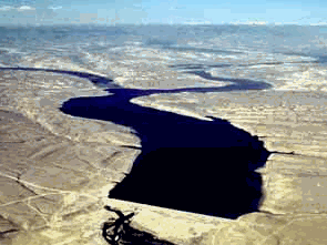
Fontenelle Dam and Reservoir
General Description
The Seedskadee Project, a participating project of the Colorado River Storage Project, is in the Upper Green River Basin in southwestern Wyoming. It provides storage and regulation of the flows of the Green River for power generation, municipal and industrial use, fish and wildlife, and recreation. The basin contains vast mineral resources of coal, trona, oil and gas, and shale that provide the basis for extensive existing and potential industrial development. Towns in the area are Rock Springs, Green River, and Kemmerer.
Plan
Unit Descriptions and Facilities
Principal features of the project are the Fontenelle Dam, Powerplant, and Reservoir. The reservoir is
operated for municipal and industrial water use, power production, flood control, and downstream fishery
and wildlife refuge.
Fontenelle Dam, Reservoir, and Reservoir
The Fontenelle Dam is located on the Green River 24 miles southeast of La Barge, Wyoming. A zoned
earthfill structure, the dam is 139 feet high with a crest length of 5,421 feet, and a volume of 5,265,000
cubic yards of material. The spillway consists of an uncontrolled crest, open chute, and stilling basin with a
design capacity of 20,200 cubic feet per second. Fontenelle Powerplant is located adjacent to the toe of the
dam, with the power penstock branching from the river outlet works. The powerplant consists of one
10,000-kilowatt generator and one 16,000-horsepower hydraulic turbine.
The reservoir has an active capacity of 150,500 acre-feet and a total capacity of 345,360 acre-feet, with a surface area of 8,058 acres. The lake is 20 miles in length when full, and has a shoreline of approximately 56 miles.
Operating agencies
The Bureau of Reclamation operates the Fontenelle Reservoir and Powerplant, and is responsible for
recreation facilities. The Fish and Wildlife Service manages the Seedskadee National Wildlife Refuge. The
Wyoming Game and Fish Commission manages the reservoir fishery and the fishery in the Green River
below the reservoir. The development farm has been transferred to the Wyoming Game and Fish
Commission for wildlife management purposes.
Development
History
The Crow Indians called it the "Seeds-ke-dee-agie," meaning "Sage Hen River," but it was the "Rio Verde"
to the Spaniards. To the mountain men it was simply the Green River. In 1812, South Pass was discovered
by fur trappers. From 1825 until 1840, the Upper Green River Basin was the crossroads for the mountain
men. After the trappers came, the covered wagons moved west along the Oregon Trail. Settlers began
homesteading lands near the river in the 1880's.
Investigations
The Seedskadee Project was originally investigated by the Bureau of Reclamation as a unit of a plan for
development in the Upper Green River Basin. This plan was presented in a 1946 report on the Colorado
River Basin. The Bureau of Reclamation carried out investigations of the Seedskadee development as an
independent project, and in November 1950 prepared a feasibility report on the Seedskadee Project, issued
as a supplement to the December 1950 report on the Colorado River Storage Project and participating
projects. These two reports were amended in October 1953 by a further supplement that brought
construction cost and project benefit estimates up to date. This latter supplement was submitted to the
Congress and was the basis for project authorization.
The definite plan report was prepared in April 1959, and in February 1961 was modified to provide for future municipal and industrial water needs. Under the provisions of Title III of the Water Supply Act of 1958 (72 Stat. 319), the Wyoming legislature authorized the Wyoming Natural Resource Board to negotiate a contract for additional capacity in the Fontenelle Reservoir for municipal and industrial water, thus increasing the total capacity of the reservoir to 345,360 acre-feet, with 150,500 acre-feet of active capacity. Following reevaluation studies, the House Committee on Interior and Insular Affairs approved construction of the powerplant and associated works.
On May 21, 1962, the Commissioner of Reclamation issued a stop-order suspending construction of irrigation features of the project until a review of Wyoming projects could be accomplished. In a program to find solutions to serious financial and economic problems encountered on high-altitude irrigation projects, and to provide guidelines for land development and water management, experimental crops were grown on 512 acres of land, using border dike, contour flooding, and circular sprinkling methods. As a result of these experimental farm studies, Fontenelle Dam, originally conceived as an irrigation storage dam, evolved toward storage of water for cities, industry, and fish and wildlife. Irrigation development has been indefinitely deferred.
Authorization
Seedskadee Project is one of the initial group of participating projects authorized with the Colorado River
Storage Project by the act of April 11, 1956 (70 Stat. 105).
Construction
Construction of Fontenelle Dam commenced in June 1961 and was completed in April 1964. In September
1965, after the reservoir had filled to capacity, water passing through relief cracks in the right abutment
carried away part of the downstream embankment. The reservoir was evacuated and a repair program
undertaken and completed in 1967. The reservoir was refilled in the winter and spring of 1968.
Construction of Fontenelle Powerplant and appurtenant facilities was started in February 1963, and
completed in January 1966. Power generation commenced in May 1968.
Benefits
Domestic, Municipal, and Industrial
Initial deliveries of municipal and industrial water to the State of Wyoming under the contract of June 14,
1962, began in 1974. Further negotiations with the State were completed on December 27, 1974 for
additional municipal and industrial deliveries.
Recreation and Fish and Wildlife
The Seedskadee National Wildlife Refuge was established by the Fish and Wildlife Service in 1965. The
refuge lies along 35 miles of the Green River, approximately 6 miles below Fontenelle Dam and 20 miles
northwest of the town of Green River. The refuge will provide habitat for waterfowl, and ultimately 18
wildlife management units will be developed. About 13,250 acres of Federal and private land have been
acquired with plans to bring the refuge to a total of about 22,000 acres. A substantial fishery has developed
in the reservoir and in the stream between the reservoir and the Flaming Gorge Reservoir. Both the stream
and reservoir are stocked with rainbow and brown trout. In the stream below the reservoir, a whitefish
population is sustained as a result of natural spawning.
Recreation facilities constructed on the west shore of the reservoir near Fontenelle Creek include sites for camping and picnicking, a boat ramp, parking, sanitary facilities, and drinking water. The reservoir has a surface area of 8,000 acres. The lake is 20 miles long when full and has a shoreline of about 56 miles.
Hydroelectric Power
Commercial power generation commenced in May 1968. The powerplant and switch yard at Fontenelle
Dam with transmission lines interconnected with the Colorado River Storage Project transmission system at
the Flaming Gorge Powerplant. Fontenelle Powerplant is located adjacent to the toe of the dam, with a 10-
foot power penstock branching from one of three river outlet works discharge conduits. The turbine has a
water discharge capacity of 1,585 cubic feet per second. Fontenelle Powerplant provides maximum
generation of power from regulated base load river flows depending upon water availability.
Flows/generation vary from 350 cubic feet per second/1 megawatt at low seasonal head to 1,550 cubic feet
per second/11 megawatt at peak runoff periods
| Statistics | |
| Region (Map) | Upper Colorado |
| State | Wyoming |
| County | Lincoln |
| Project | Seedskadee |
| Dam type | Earthfill |
| Location | 24 mi SE La Barge, WY |
| Watercourse | Green River |
| Reservoir | Fontenelle |
| Construction Date | 1960-1963 |
| Hydraulics | |
| Normal Water Surface Elev | 6506 ft |
| Hydraulic Height | 114 ft |
| Service Spillway Type: | |
| Uncontrolled Crest | Yes |
| Morning-Glory | No |
| Crest Length | 300 ft |
| Gated | No |
| Capacity at Elev | 6513.1 ft, 20,000 cfs |
| Auxiliary Spillway | No |
| Capacity at Elev. | 0 cfs |
| Outlet Works Capacity at: | |
| Elevation 6513.1.0 ft., | 16,800 cfs |
| Dimensions | |
| Crest Elevation of Dam | 6,519 ft |
| Structural Height of Dam | 139 ft |
| Crest Length | 5,421 ft |
| Top of Joint Use | 6,506 ft |
| Top of Active Conservation | 6,506 ft |
| Top of Inactive Conservation | 6,484.9 ft |
| Top of Dead Storage | 6408 ft |
| Hydrology | |
| Drainage Area | 4,175 sq mi |
| Hydrometeorological Report | HMR |
| Flood Type | General |
| Probable Maximum Flood (PMF) Report: | |
| Peak Inflow | 6,200 cfs |
| Inflow Volume | 841,000 acre-ft |
| Flow Duration | 20 days |
| PMF Routing MWS Elev | x.0 ft |
| Initial Routing Elev | x.0 ft |
| Study Date: 3/30/1981 | |