Wyoming State Water Plan
Wyoming State Water Plan
Wyoming Water Development Office
6920 Yellowtail Rd
Cheyenne, WY 82002
Phone: 307-777-7626

Wyoming Water Development Office
6920 Yellowtail Rd
Cheyenne, WY 82002
Phone: 307-777-7626


| SUBJECT: | Green River Basin Plan Surface Water Quality |
| PREPARED BY: | Jake Strohman, States West Water Resources Corporation |
Introduction
The purpose of this water quality section is to identify on-going watershed management planning efforts; define opportunities for potential cooperation and coordination among these efforts; identify basin-wide opportunities to enhance or protect water quality; and, to identify water quality issues within the Green River Water Plan area. Groundwater quality is provided separately in the section on groundwater availability.
The quality of water refers to its physical, chemical, radiological, biological and bacteriological properties. The concentration levels of various constituents within the water properties dictate the uses and potential uses of a water body. Quality of a water body can be impacted from the natural processes on the environment or from manmade actions. The success of a water development project is dependent on the ability of the source to meet the water quality needs of the proposed use(s). In addition, the project itself must protect existing and potential uses of waters of the state and interstate salinity standards.
The State of Wyoming passed enabling legislation known as the Environmental Quality Act in 1973. The purpose of the law was directed at the concern that pollution "will imperil public health and welfare, create public and private nuisances, be harmful to wildlife, fish and aquatic life, and impair domestic, agricultural, industrial, recreational and other beneficial uses" (Environmental Quality Act 1973). The declared policy of the law was to enable the state "to prevent, reduce and eliminate pollution; to preserve, and enhance the water and reclaim the land of Wyoming; to plan development, use, reclamation, preservation and enhancement of the air, land, and water resources of the state; to preserve and exercise the primary responsibilities and rights of the state of Wyoming; to secure cooperation between agencies of the state, agencies of other states, interstate agencies, and the federal government in carrying out these objectives"(Environmental Quality Act 1973). Recognizing the importance of public involvement, the Wyoming Environmental Quality Act contains policy and rule development procedures that provide more public involvement than other state agencies.
The Water Quality Division (WQD) of the Department of Environmental Quality (DEQ) is the designated state agency for water quality management in the State of Wyoming. Given the above directives, the WQD has developed a large number of water quality protection programs. These programs deal with point (PS) and non-point sources (NPS) of pollution and their potential impacts to surface water (SW) and groundwater (GW). Table 1 provides a summary of state programs directed at water quality. Table 1 also contains some federal programs where a similar state program does not exist or where Wyoming does not have primacy of a federal program.
The federal government has been provided many authorities to protect and clean up water quality and the environment. Examples of these authorities are the Clean Water Act, Safe Drinking Water Act, Federal Insecticide, Fungicide and Rodenticide Act, Pollution Prevention Act, National Environmental Protection Act, Solid Waste Disposal Act, Toxic Substance Control Act, Clean Air Act, and others. Most of the federal programs dealing with water quality allow the states to obtain primacy to administer the federal programs. However, even if a state has primacy for a federal program, the U.S. Environmental Protection Agency (EPA) has the ability to take action if a state is not administering a program to their satisfaction and, in some cases, EPA is required by federal law to step in if a state fails to take appropriate action.
WATER QUALITY STANDARDS
Surface Water: Pursuant to the Environmental Quality Act, the WQD developed and implemented surface water quality standards contained in Chapter 1, Wyoming Water Quality Rules and Regulations in 1974. Chapter 1 contains numerical and narrative standards to establish effluent limitations for those discharges requiring control via permits to discharge in the case of point sources and best management practices in the case of nonpoint sources. The water quality standards apply to all periods of flow except low flow conditions as described in Section 11 of Chapter 1.
Surface water classification is currently separated into four different classes:
- Class 1 are those surface waters in which no further water quality degradation by point source
discharges other than dams will be allowed.
- Class 2 are those surface waters, other than Class 1, which are determined to be presently supporting
game fish or have the hydrologic and natural water quality potential to support game fish.
- Class 3 are those surface waters, other than Class 1, which are determined to be presently supporting
nongame fish only or have the hydrologic and natural water quality potential to support nongame fish
only.
- Class 4 are those surface waters, other than Class 1, which are determined to not have the hydrologic
or natural water quality potential to support fish and include all intermittent and ephemeral streams.
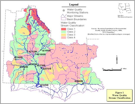
Appendix A of Chapter 1 contains a listing of the classification of all surface waters that are named on the USGS 1:500,000 Hydrologic Map of Wyoming. Also included in Appendix A is a map showing stream classifications and USGS stream gaging stations. The current stream classifications of the Green River Basin, Great Divide Basin and the Little Snake River Basin are shown in Figure 1 of this technical memo.
WQD is required by Section 6 of Chapter 1 to review and conference with the State Engineer concerning proposed new diversions that could cause violations of surface water standards.
Interstate Water Quality Standards: The Green River Basin and Little Snake River Basin are part of the Colorado River Basin. The Colorado River Basin Salinity Forum is an organization composed of water quality and water resource representatives of the states of Arizona, California, Colorado, Nevada, New Mexico, Utah and Wyoming with the responsibility for developing salinity standards and criteria for the waters of the Colorado River Basin. The basin-wide water quality standards for salinity consists of numeric water quality criteria at three lower Colorado River stations and a Plan of Implementation that describes the overall program. The Plan of Implementation also describes specific salinity control projects that are being and will be implemented to remove sufficient salt from the river system so the salinity concentrations of the River's waters arriving at the lower three stations do not exceed the numeric criteria values. Under the federal Clean Water Act, the water quality standards for salinity are reviewed every three years and the Plan of Implementation is jointly revised and adjusted by the states and involved federal agencies. A separate memorandum "Colorado River Basin Salinity Control Program" addresses salinity in more detail.
Ground water: In 1980, the WQD developed and implemented groundwater quality standards, contained in Chapter 8 of the Wyoming Water Quality Rules and Regulations, to protect existing and future groundwater uses. These regulations contain narrative and numerical standards used to classify ground waters of the State and provide criteria to determine acceptable concentration of discharges to ground water. These standards are also used to determine the degree of groundwater cleanup necessary to restore polluted ground water to pre-contamination use.
The WQD uses a two-tiered classification system. The first tier requires protection of existing uses regardless of water quality considerations. The second tier requires protection of all potential uses based on ambient groundwater quality. The highest standard of groundwater quality maintenance, given existing or potential uses, determines the governing tier. Maps showing groundwater classification are not available because the availability of well data and the diverse geology of the State prohibit accurate regional delineation of groundwater classification. Unlike surface water standards, groundwater classification is invoked only when a discharge to ground water has occurred or is proposed.
The U.S. Nuclear Regulatory Commission has groundwater standards to regulate facilities under their jurisdiction including uranium mine and mill operations. As mentioned in the introduction, ground water quality in the Green River Basin is characterized in a separate memorandum.
BASIN SURFACE WATER QUALITY
The Department of Environmental Quality has completed a stream classification for all surface water bodies in the project study area. The classification indicates whether a stream is currently supporting or has the potential to support the uses of that classification. The entire Great Divide Basin is listed as Class 4. Stream segments or water bodies that currently do not meet the classification are provided in the 303(d) list.
The streams in or near the mountains contain water quality rated as good. The water quality of these mountain streams deteriorates as it flows across the plains. The degradation of water quality is caused by both natural and manmade sources. The water quality of many streams originating in the plains is rated as fair to poor. The water quality of surface water bodies is obtained from U.S. Geological Survey reports of sampling accomplished from surface water stations. The systematic water quality sampling stations are shown in Figure 1.
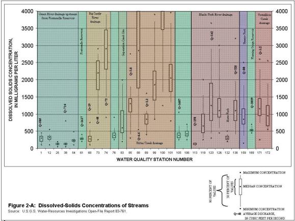
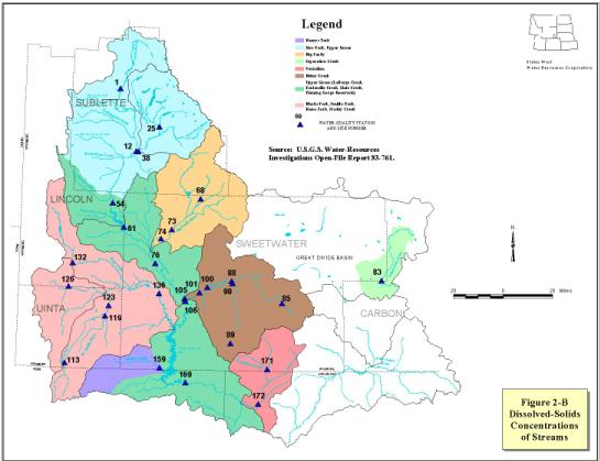
The dissolved solids concentration of surface water stations in the project area are shown in Figure 2. All of the Green River Drainage above Fontenelle Reservoir and the Green River itself above Flaming Gorge Reservoir contain median dissolved solids concentrations of less than 500 mg/L. Flaming Gorge Reservoir has a median at or slightly above 500 mg/L. The Little Sandy River has a median less than 500 mg/L at the Sublette County line while monitoring stations downstream on the Big Sandy River show concentrations increasing up to about 3,000 mg/L before the confluence with the Green River. The Blacks Fork River Drainage and the Henry's Fork have a median dissolved solids concentrations of streams in the range from 500 to 1200 mg/L except for the Blacks Fork River near the Utah State line and the Hams Fork near Kemmerer which has medians below 500 mg/L. The Bitter Creek drainage has median dissolved solids concentrations ranging from approximately 750 to 2900 mg/L with the exception of Killpecker Creek which has a median above 4,000mg/L. The Vermillion Creek Drainage has a median of approximately 1,000 mg/L.
All water bodies in the drainage system are within the acceptable water quality pH range of 6.5 to 9.0. However, pH readings for the Green River Basin indicate the water as being slightly alkaline. The temperature of water in the Green River Basin varies from 0 degrees Celsius in the winter to 25 degrees Celsius in the summer.
The concentrations of total phosphorous in some streams frequently exceed the limits recommended to protect reservoirs and streams from nuisance growth of algae and other aquatic plants. Many of the reservoirs and lakes experience phytoplankton blooms in late summer and early fall due to nutrient and eutrophic water quality.
Most of the sediment in the Green River Basin is deposited in Fontenelle and Flaming Gorge Reservoirs with very little impact on the down river states. The Department of Environmental Quality has expressed concern on sediment loading in the Blacks Fork River Drainage and the Little Snake River Drainage.
Few bacteria concentrations in water bodies within the study area exceed the Department of Environmental Quality surface water standards. The segments that do not meet these standards are listed in the 303(d) report. Most of these water bodies that do not meet the bacteria requirements are being investigated to determine if the cause is domestic wastewater treatment discharges.
The Department of Environmental Quality has recently increased surface water monitoring to address 1999 amendments to the Environmental Quality Act under W.S. 35-11-103 ( c ) & 302 (b) directed at "credible data." Part of this monitoring program will be directed at monitoring invertebrate communities in the Green River Basin. The invertebrates population surveys by USGS show water quality in the plains is not as good as water quality in mountain streams although overall basin invertebrates indicate good water quality. Invertebrates are normally important because they are a source of food for fish.
To view specific water quality data from USGS river stations in the project area, visit http://wy.water.usgs.gov/
TOTAL MAXIMUM DAILY LOADS/303 (D) LIST
All water bodies within the delineated planning area meet the existing classification uses with the exception of those water bodies contained in the 1998 303(d) list in Appendix 1. Section 303(d) of the Clean Water Act (CWA) requires the State of Wyoming to identify water bodies that do not meet designated uses and are not expected to meet water quality standards after application of technology- based controls; identify a priority ranking for each water quality limited segment; and develop total maximum daily loads (TMDL) to restore each water body segment to pre-designated uses. EPA requires each state to submit their lists of impaired or threatened water bodies every two years and is required to accomplish the work if a state fails to perform the required activities.
A simple explanation of TMDL is the ability of a water body to assimilate pollution and continue to meet the designated uses. A TMDL must be established for each pollutant which is a source of stream impairment. The TMDL process provides a way to document how water quality standards are being implemented; provides the framework for thorough watershed planning for multiple sources or causes of impairment; provides states an opportunity to identify priorities based on risk and target TMDLs for completion; and promotes cost-effective solutions to pollution. The minimum requirements of a TMDL are:
- application of TMDLs result in maintaining and attaining water quality standards;
- TMDLs must contain a margin of safety and consider seasonality;
- TMDLs include a quantified pollutant reduction target;
- TMDLs must consider all significant sources;
- TMDLs are supported by an appropriate level of technical analysis;
- TMDLs must have a quantified target or endpoint (i.e. water quality standard);
- TMDLs apportion responsibility for taking actions; and
- TMDLs involve some level of public involvement
TMDL implementation tools vary and include: NPDES permits; other federal laws and requirements; state and local laws and ordinances; and individual voluntary-based actions. The biggest challenge of the TMDL process occurs when a watershed segment has been impacted and the pollution is determined to be a combination of point and nonpoint sources. The solution has to be a balanced approach directed at correcting the problems of each river, stream, lake or estuary. This balanced approach may be difficult to accomplish due to the administration of point sources of pollution by permits and the administration of nonpoint sources by best management practices.
Haggarty Creek TMDL
Haggarty Creek, in the Little Snake Drainage and in the Sierra Madre mountains does not support aquatic life at levels comparable to unimpaired waters in the area due to elevated concentrations of copper for approximately 4 miles downstream of the inactive Ferris Haggarty Mine. In 1996, the U.S. Environmental Protection Agency deferred the listing of the mine as a superfund site allowing the State of Wyoming, through the Abandoned Mine Lands (AML) Division of the DEQ, to investigate the site and recommend solutions to reduce copper concentrations that will allow water quality sufficient to support trout populations. The mine is located at approximately 9,500 feet above sea level with no commercial electrical power service to the region. Hence, passive (using flow through passive treatment media) rather than active (using electro-mechanical equipment) treatment is preferred.
A consultant, contracted by the AML, has completed an investigation of the site and has conducted pilot scale passive treatment studies for copper removal. The consultant has concluded that the water can viably be treated by passive treatment. Full-scale treatment is scheduled for installation in 2000. However, right-of-way acquisition may delay the timing of installation.
The WQD developed a draft TMDL for the section of Haggarty Creek impaired by the mine discharge in March of 1999. This draft has not been finalized due to the need to complete ambient water quality sampling upstream of the Ferris Haggarty Mine, investigate the ambient levels of copper in streams undisturbed by mining activities, and the determination of the actual efficiency of copper removal after installation of the passive treatment system. The field studies to be conducted by WQD will encompass all tributaries of Haggarty Creek.
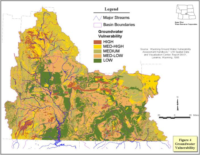
AQUIFER SENSITIVITY/VULNERABILITY
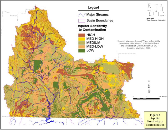
A system to assess the sensitivity and vulnerability of groundwater to surface water or other surface activities that have the potential to pollute has been developed. The Wyoming Department of Environmental Quality, in conjunction with the Wyoming Department of Agriculture and the U.S. EPA contracted with the University of Wyoming to develop statewide vulnerability maps to assess the tendency or likelihood for contaminants to reach a specified position in the groundwater system after introduction at the same location above the uppermost aquifer. Aquifer vulnerability maps were developed to combine factors associated with the hydrogeological setting with indicators of the nature and extent of potential contaminant sources to determine the potential impact of these anthropogenic influences on the groundwater quality. In lay person terms, it is the potential of a contaminant applied at the surface to impact the water quality of the shallow uppermost aquifer at that application location. See Figure 3 for aquifer sensitivity of the project area and Figure 4 for vulnerability to pesticides for the project area.
References
Colorado River Basin Salinity Control Forum, October 1999, Supplemental Report on the 1999 Review "Water Quality Standards for Salinity Colorado River System."
Department of Environmental Quality, Water Quality Division, Current Edition, Wyoming Water Quality Rules and Regulations, Chapters 1 through 22.
Department of Environmental Quality, Water Quality Division, December 1999, "Draft Wyoming Nonpoint Source Management Plan Update."
Department of Environmental Quality, Water Quality Division, January 2000, "Draft Source Water Protection Program."
Department of Environmental Quality, Water Quality Division, July 1997, "Total Maximum Daily Load (TMDL) Work Plan."
Department of Environmental Quality, Water Quality Division, June 2000, Wyoming's 305(b) Report, "Water Quality Assessment."
Department of Environmental Quality, Water Quality Division, June 1998, Watershed Program "Five Year Comprehensive Monitoring Plan."
Department of Environmental Quality, Water Quality Division, June 1998, "Wyoming Wellhead Protection Program."
Department of Environmental Quality, Water Quality Division, March 1998, "Wyoming's 1998 303(d) Waterbody List."
DiRienzo, Bill, April-May 2000, Wyoming Department of Environmental Quality, Water Quality Division, Personal Interview.
Goyn, Lanny, June 2000, Wyoming Department of Environmental Quality, Water Quality Division, Personal Interview.
Miller, Cheryl, May 2000, United States Department of Interior, Geologic Survey, Personal Interview.
Ogle, Kathy, April 2000, United States Department of Interior, Geologic Survey, Personal Interview. Richmond, Tim , June 2000, Wyoming Department of Environmental Quality, Abandoned Mines Division, Personal Interview.
Smith, Jack, April 2000, Wyoming Department of Environmental Quality, Water Quality Division, Personal Interview.
United States Department of Interior, U.S. Geologic Survey, 1988, Water Resources Investigations Report 87-4022, "Streamflow Characteristics of the Green, Bear, and Snake River Basins, Wyoming through 1984."
United States Department of Interior, U.S. Geologic Survey, 1988, Water Resources Investigations Report 99-4097, "Streamflow and Dissolved-Solids Trends, Through 1996, In the Colorado River Basin Colorado, Utah, and Wyoming."
United States Department of Interior, U.S. Geologic Survey, October 1985, Open File Report 83-761 "Hydrology of Area 52 , Rocky Mountain Coal Province, Wyoming, Colorado, Idaho, and Utah."
United States Department of Interior, U.S. Geologic Survey, Water Year 1997-1999, Water Quality Data, Green River Basin, http://wy.water.usgs.gov/ United States Environmental Protection Agency, 1999, "Clean Water Action Plan Fact Sheet," http://cleanwater.gov/news/fact_sheet.html [new link 10/2009 HERE]
University of Wyoming, Water Resources Center and Wyoming State Geological Survey, 1998, SDVC Report 98-01, Volume I & II, "Ground Water Vulnerability Assessment Handbook."
Water Quality Programs
| Program | Implementing Agency | Authority | Type | Program Description |
| NPDES | DEQ/WQD | EQA |
SW PS |
Any discharge to surface waters of the state requires a permit to discharge. Each permitted discharge must meet effluent limitations within the TMDL allocations and maintain the use of the receiving water body. There are currently 70 NPDES permits in the study area that are classified as not being a storm water permit. There are several hundred storm water permits in the study area. Information on this program is available at http://deq.state.wy.us/wqd.htm [new link 10/2009 HERE] |
| Permit to Construct | DEQ/WQD | EQA Article 3 Chapters 3, 5, 11, 12, 15, 20, 21 |
SW GW PS |
Any public water supply system or any facility capable of causing or contributing to pollution is required to obtain a permit to construct prior to commencing construction. This program is directed at ensuring facilities are designed, constructed and operated to protect ground water and surface water resources. Chapter 5 requires certified operators for public water and sewage facilities. |
| Nonpoint Source Management and Control | DEQ/WQD | EQA Article 3, Section 319 of CWA |
SW GW NPS |
The state nonpoint source control program is
a voluntary and incentive based program. The program seeks to control through
education and encouragement of Best Management Practices, including demonstration,
information and education, and restoration projects. Assessments and demonstration
projects are selected for funding by the Wyoming Nonpoint Source Task force. The
NPS Program manages Wyoming's allocations provided as grants by Section 319 and
205(j) of the Clean Water Act. |
| Water Quality Assessments & Impaired Surface Water Bodies | DEQ/WQD | EQA Article 3, S. 305(b) & 303(d) of CWA |
SW GW NPS PS |
Section 305(b) of the Clean Water Act requires each state to assess and report on the quality of waters on a 2 year frequency. Section 303(d) requires each state every two years to list water bodies which are water quality impaired or threatened. This report and list are available at http://deq.state.wy.us/wqd/wtrshedpg.htm [new link 10/2009 HERE] |
| Surface Water Monitoring | DEQ/WQD | EQA Article 3 |
SW PS NPS |
The WQD is progressing toward a more comprehensive monitoring and assessment program. In 1996, the Legislature passed a credible data law requiring the WQD to ensure all data used in listing impaired or threatened waters requiring scientifically valid data to be used. This credible data law has significantly increased monitoring of surface water in Wyoming. Monitoring efforts by WQD to comply with the credible data law are contained in the 305(b) report. |
| 404 Permit | US Army Corps of Engineers | Clean Water Act | SW PS NPS |
A permit is required from the Army Corps of Engineers to discharge dredge or fill material into navigable waters. |
| 401 Certifications | DEQ/WQD | EQA Article 3 |
SW PS NPS |
Any application for a Army Corp of Engineers 404 dredge and fill permit requires a certification from WQD that the dredge or fill will comply with all the requirements of Sections 301,302,303, 306 & 307 of the Clean Water Act. |
| Spill Program | DEQ/WQD | EQA Article 3 Chapter 4 |
SW GW PS |
Any person owning or having control over oil or a hazardous substance, which after release, enters or threatens to enter waters of the state shall take action to stop and contain the release, notify WQD, correct the cause, clean up the release and dispose of the waste in an acceptable manner. |
| Source Water Protection | DEQ/WQD | EQA Article 3 |
SW GW |
Wyoming has developed a voluntary source water protection program as required by each state under Section 1453 of the SDWA. Source water assessment involves four steps: delineate the area which contributes water to the well or surface water intake; inventory of potential sources of contamination; complete an analysis of the susceptibility of the well or intake to contamination from the previous inventory; and draft up a report summarizing the findings. |
| Wellhead Protection Program | DEQ/WQD | EQA Article 3 |
GW | Wyoming has developed and received approval from EPA endorsing its wellhead protection program developed pursuant to Section 1428 of the SDWA. The program is voluntary and allows public water supply systems to protect groundwater sources of supply. |
| Wellhead Protection Program | DEQ/WQD | EQA Article 3 |
GW | Wyoming has developed and received approval from EPA endorsing its wellhead protection program developed pursuant to Section 1428 of the SDWA. The program is voluntary and allows public water supply systems to protect groundwater sources. |
| Abandoned Mines | DEQ/AML | Article 12 | PS NPS SW GW |
The abandoned mines program accomplishes reclamation of eligible properties adversely affected by mining prior to August 3, 1977. Eligible Public facilities and utilities adversely affected by mining prior to August 3, 1977 and the construction of new public facilities or utilities in communities impacted by coal or mineral mining and processing practices. |
| Landfills & Hazardous Wastes | DEQ/SHWD | EQA Article 5 |
PS SW GW |
No person, except when authorized by a SHWD permit, shall locate, construct, operate or close a solid waste management facility or modify the design, construction or operation of a solid waste management facility. The SHWD has primacy of the federal RCRA program regulating hazardous waste generators and transporters, hazardous waste treatment, storage and disposal facility operators, and hazardous waste corrective actions. |
| Superfund Sites | US EPA | CERCLA | EPA regulates superfund sites in Wyoming. | |
| Well Construction & Abandonment | WY State Engineer (SEO) | SEO Regulations | PS GW |
The state engineer has regulations requiring adequate design, construction and abandonment of wells to protect groundwater resources. |
| Colorado River Salinity Standards | AZ, CA, CO, NV, NM, UT, WY | P.L. 93-320 Forum Policies WY/WQD Ch. 6 |
SW GW PS NPS |
The 7 states in the Colorado River Basin form an interstate forum with a goal directed at maintenance of water quality so that numeric criteria are not exceeded in the lower basin. The forum has developed policies for surface water discharges from municipal and industrial sources as well as natural occurring groundwater and fish hatcheries. The Big Sandy Salinity Project in Wyoming was directed at NPS returns to SW and GW from agricultural irrigation operations. |
| Wellhead Protection Program | DEQ/WQD | EQA Article 3 |
GW | Wyoming has developed and received approval from EPA endorsing its wellhead protection program developed pursuant to Section 1428 of the SDWA. The program is voluntary and allows public water supply systems to protect groundwater sources of supply. |
| Underground Storage Tanks | DEQ/WQD | EQA Article 14 |
PS SW GW |
Wyoming has primacy of the federal RCRA program regulating underground storage tanks (UST). This program regulates the design, construction and operation of USTs and provides financial responsibility for UST and commercial above ground storage tank owner/operators. In addition, a cleanup fund exists to remediate contamination caused by leaking USTs. |
| Underground Injection Control Wells | DEQ/WQD
DEQ/LQD
OGCC |
EQA Article 3 Chapters 13 & 16
Article 4
W.S. 30-5-101 thru 305 |
PS GW |
Any person who construct, installs, or operates a Class
I, IV, or V underground injection control well must first obtain a permit from the
DEQ/WQD. Class I wells are deep injection wells that discharge into a Class VI
groundwater formation and include hazardous waste wells of which there are none in Wyoming.
Commercial Class II wells are regulated as a Class I well. Class IV wells inject hazardous
waste into shallow aquifers and are prohibited. Class V wells are wells, other than the
other 4 classifications, injecting into or above underground sources of drinking water
such as drain fields, air conditioning return wells, dry wells, etc.
Any person injecting into a class III well must obtain a permit or license from DEQ/WQD. A class III well injects into or above a drinking water for the purpose of extracting minerals. The most common in situ mining wells in Wyoming are uranium and soda ash. Any person injecting into a noncommercial class II well is required to obtain a permit from the Wyoming Oil and Gas Conservation Commission. Class II wells inject fluids which are brought to the surface in connection with natural gas storage operations or conventional oil and gas production, fluids for enhanced recovery of oil or natural gas and for storage of hydrocarbons. |
| State Pesticide Management Plan (SMP) | WY Dept. of Agriculture | W.S. 35-7-350 thru 374 | NPS SW GW |
The Department of Agriculture has developed a SMP directed at the protection of water resources from the application of pesticides. The SMP program has received EPA approval. |
| SMP GW Monitoring | WY Dept. of Agriculture | W.S. 35-7-350 thru 374 | GW | Utilizing pesticide registration fees and funding from 319 grants, the USGS has been contracted to conduct a state-wide assessment of the contamination of groundwater caused by pesticides. Of the counties completed at the time of this report, no levels above drinking water maximum contaminant levels have been found. Monitoring results can be accessed at http://wy.water.usgs.gov/projects/pests/index.htm [new link 10/2009 HERE] |
| Mines | DEQ/LQD | EQA Article 4 |
PS NPS SW GW |
License or permits are required for any mining operation or operation by which solid minerals are intended to be extracted from the earth. This includes surface and underground mining. The extraction of sand, gravel, dirt, scoria, limestone, dolomite, shale, ballast, or feldspar by a landowner for noncommercial use does not require a permit nor does an area of less than 10 surface acres under certain conditions. |
From List A: Water bodies requiring TMDLs, for which there is credible data that indicates that reach does not support all its designated uses.
Green River Hams Fork Waterbody ID: WYGR14040107-020-3 has a listed credible impairment of pH with a source noted as nonpoint source contamination and states that cold water fish are threatened or impaired.
From List B: Water bodies requiring TMDLs in the next two years due to routine NPDES renewal process for permits where Waste Load Allocations are involved.
Green River Smiths Fork Waterbody ID: WYGR14040107-041-2 has a listed data source from the Mountain View WWTP with contaminants of concern being ammonia, fecal, and total residual chlorine.
Green River Hams Fork Waterbody ID: WYGR14040107-020-3 Kemmerer WWTP with the same information as Mountain View WWTP.
Little Snake River Waterbody ID: WYLS 14050003-001-4 Dixon WWTP with the same information as Mountain View WWPT
From List C: Water bodies requiring TMDLs, for which there is data indicating trends away from supporting beneficial use and where there are improvement plans or other corrective actions in progress.
Green River East Fork Smiths Fork Waterbody ID: WYGR14040107-15-9-1
Green River West Fork Smiths Fork
WYGR14040107-04-2-2
Green River Willow Creek
WYGR14040107-27-9-1
The previously mentioned waterbodies are showing credible impairments of silt.
Green River Reardon Draw Waterbody ID: WYGR14040101-28-0-1 is showing a credible impairment of physical degradation.
Little Snake Littlefield Creek WYLS 14050004-06-7-1All of the Little Snake River tributaries referenced above have silt listed as a credible impairment.
Little Snake Loco Creek
WYLS 14050003-07-2-2
Loco Creek
WYLS 14050003-07-1-1
Loco Creek West Fork
WYLS 14050003-07-0-1
The three Little Snake River tributaries listed immediately above are showing credible impairments of silt, temperature and nutrients.
Little Snake Muddy Creek WYLS 14050004-00-7-3 shows credible impairments of silt and salinity from total dissolved solids.
From List D: Water bodies removed from the 1996 303(d) list of water bodies requiring TMDLs.
Green River Pixley Creek WYGR 14040101-228-1 was previously impaired by silt and salinity.
Little Snake Ledford Slough WYGR 14050003 was previously impaired by ammonia, chorine and pathogens.
From List E: List of water bodies from the 1996 303(d) list requiring further monitoring to determine beneficial use attainment.
303(d) E LIST
| Basin | Name | Waterbody ID | Cl | Monitor Reason |
| GR | Birch Creek | WYGR14040101-051-2 | 3 | no primary data |
| GR | Dry Piney Creek | WYGR14040101-278-1 | 2 | inconclusive data |
| GR | Fontenelle Creek | WYGR14040101-049-2 | 2 | long term monitoring |
| GR | Fontenelle Creek | WYGR14040101-186-1 | 2 | inconclusive data |
| GR | Green River | WYGR14040101-012-4 | 2 | inconclusive data |
| GR | Green River | WYGR14040101-012-4 | 2 | no primary data |
| GR | Muddy Creek | WYGR14040101-207-1 | 2 | inconclusive data |
| GR | Rock Creek | WYGR14040101-194-1 | 2 | inconclusive data |
| GR | New Fork River | WYGR14040102-029-2 | 2 | inconclusive data |
| GR | New Fork River | WYGR14040101-060-2 | 2 | inconclusive data |
| GR | Pole Creek | WYGR14040102-238-1 | 2 | inconclusive data |
| GR | Alkali Creek | WYGR14040103-128-1 | 4 | no primary data |
| GR | Green River | WYGR14040103-026-3 | 2 | no primary data |
| GR | Big Sandy River | WYGR14040104-026-3 | 2 | no primary data |
| GR | Little Sandy River | WYGR14040104-149-1 | 2 | no primary data |
| GR | Bitter Creek | WYGR14040105-024-3 | 4 | old fecal, selenium |
| GR | Current Creek | WYGR14040106-034-2 | 2 | ongoing study |
| GR | Flaming Gorge Reservoir | WYGR14040106-001-5 | 2 | no primary data |
| GR | Green River | WYGR14040106-006-4 | 2 | inconclusive data |
| GR | Red Creek | WYGR14040106-036-2 | 2 | inconclusive data |
| GR | GR Blacks Fork | WYGR14040107-002-5 | 2 | no primary data |
| GR | GR Blacks Fork | WYGR14040107-004-5 | 2 | no primary data |
| GR | GR Hams Fork | WYGR14040107-045-2 | 2 | no primary data |
| GR | GR Smiths Fork | WYGR14040107-017-3 | 2 | no recent data |
| GR | Willow Creek | WYGR14040107-171-1 | 2 | no primary data |
| GR | Albert Creek | WYGR14040108-021-3 | 3 | no primary data |
| GR | Vermillion Creek | WYGR14040109-025-3 | 2 | inconclusive data |
| GR | Vermillion Creek N. Fork | WYGR14040109-124-1 | 2 | inconclusive data |