Wyoming State Water Plan
Wyoming State Water Plan
Wyoming Water Development Office
6920 Yellowtail Rd
Cheyenne, WY 82002
Phone: 307-777-7626

Wyoming Water Development Office
6920 Yellowtail Rd
Cheyenne, WY 82002
Phone: 307-777-7626


| SUBJECT: | Green River Basin Plan Irrigation Diversion Operation and Description |
| PREPARED BY: | Pat Tyrrell, Jennifer Russell, States West Water Resources |
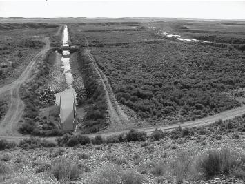
Big Sandy Ditch, Big Sandy River
Diversion Description: Diversion consists of a wood headgate. No diversion dam exists.1
Conveyance Description: Open Channel Canal, approximately 5.5 miles in length.1
Wyoming Water Rights Summary:
| Priority Date (M-D-Y) | Permit Number |
Permitted Use | Acres | Flow (cfs) |
Cumulative Flow (cfs) | Comments |
| 12-12-1900 | 2957 | Irrigation | 33.00 | 0.47 | 0.47 | Originally named Johnson & Gasswint Ditch |
| 11-25-1901 | 3566 | Domestic, Irrigation, Stock | 350.00 | 5.00 | 5.47 | POD/MOC change from Tunnel Ditch |
| 09-04-1905 | 1427E | Domestic, Irrigation, Stock | 516.00 | 7.36 | 12.83 | Originally named Johnson & Gasswint Ditch |
| 01-06-1915 | 3100E | Irrigation | 20.00 | 0.29 | 13.12 | Originally named Johnson & Gasswint Ditch |
Storage Rights: None.
Estimated Canal Losses: Typical (10%).1
Irrigation Practices: Information not available at time of report.
Crop Types / Consumptive Use: Information not available at time of report.
Return Flows: Return flows are delivered to Big Sandy River at Water Hole Draw.2
Other Operational Information: Information not available at time of report.
|
Big Sandy Ditch, Big Sandy River, Diversion Data
| Wateryear | May | June | July | August | September | |||||
| Average (cfs) | Monthly Total (AF) | Average (cfs) | Monthly Total (AF) | Average (cfs) | Monthly Total (AF) | Average (cfs) | Monthly Total (AF) | Average (cfs) | Monthly Total (AF) | |
| 1975 | 14.12 | 840.26 | 17.48 | 1,075.04 | 4.94 | 303.47 | 4.47 | 265.78 | ||
| 1976 | 6.53 | 401.77 | 12.48 | 742.39 | 8.67 | 532.96 | 3.39 | 208.32 | 3.10 | 184.46 |
| 1978 | 11.45 | 704.13 | 16.63 | 989.75 | 11.71 | 720.00 | 4.70 | 279.67 | ||
| 1980 | 10.74 | 639.07 | 8.36 | 514.04 | 6.33 | 389.22 | 4.65 | 276.69 | ||
| 1981 | ||||||||||
| 1982 | 27.33 | 1,626.25 | 17.76 | 1,092.02 | 5.24 | 322.20 | ||||
| 1983 | 10.34 | 615.27 | 9.42 | 579.21 | 4.60 | 282.84 | ||||
| 1984 | 11.06 | 658.12 | 5.57 | 342.49 | ||||||
| 1985 | ||||||||||
| 1986 | ||||||||||
| 1987 | ||||||||||
| 1988 | ||||||||||
| 1989 | ||||||||||
| 1990 | ||||||||||
| 1991 | ||||||||||
| 1992 | ||||||||||
| 1993 | ||||||||||
| 1994 | ||||||||||
| 1995 | ||||||||||
| 1996 | 4.82 | 286.81 | 4.10 | 243.97 | ||||||
| 1997 | ||||||||||
| 1998 | 8.92 | 548.47 | 3.61 | 214.81 | ||||||
| Averages: | 8.99 | 552.95 | 13.44 | 799.74 | 11.28 | 693.68 | 5.57 | 342.42 | 4.10 | 244.23 |
Data:
1980: 5/20, 6 cfs; 5/29, 5 cfs; 6/3, 7 cfs; 6/10, 11 cfs; 6/17, 9 cfs; 6/18, 13 cfs; 6/23, 13 cfs; 7/9, 11 cfs; 7/15, 8 cfs; 7/24, 6 cfs; 7/28, 6 cfs; 8/8, 5 cfs; 8/12, 5 cfs; 8/21, 8 cfs; 9/22, 4 cfs; 9/29, 4 cfs.
1982 (all est): 6/3, 30 cfs; 6/22, 30 cfs; 7/8, 22 cfs; 7/12, 15 cfs; 7/23, 20 cfs; 8/5, off; 8/30, 12 cfs.
1983: 5/17, off; 6/17, 12 cfs; 6/29, 12 cfs; 7/19, 9 cfs; 7/27, 8 cfs; 8/22, 3 cfs; 9/12, 6 cfs.
1984: 6/1, 12 cfs; 6/12, 10 cfs; 6/29, 12 cfs; 7/5, 11 cfs; 7/20, 1.5 cfs (est); 7/25, 3 cfs (est); 9/25, 6 cfs.
1996: 6/11, 5 cfs (est); 6/28, 12 cfs (est); 9/4, 7.5 cfs (est); 9/24, 4.8 cfs.
1997: 7/21, 9.4 cfs; 8/1, 10.1 cfs; 8/11, 10.5 cfs (est).
1998: 5/13, 8 cfs (est); 7/29, 11.9 cfs; 8/20, 8 cfs (est); 9/17, 6.6 cfs.
Supply: 1980, average; 1981, slightly below average; 1982, average; 1983, above average; 1984, above average; 1985, slightly below average; 1986, average; 1987, average; 1988, below average; 1989, below average; 1990, below average; 1991, slightly below average; 1992; below average; 1993, slightly below average; 1994, below average; 1995, slightly above average; 1996, average; 1997, average; 1998, slightly above average.
Source: State Engineer's Office, Annual Hydrographers' Reports.
| BIG SANDY RIVER - BIG SANDY DITCH | STATION NO. 006140.00 |
| LATITUDE 0-00-00 LONGITUDE 0-00-00 | |
| SECTION 0 TOWNSHIP 0 RANGE 0 P.M. | |
| ELEVATION UNKNOWN DRAINAGE AREA UNKNOWN | |
| NONCONTRIBUTING AREA UNKNOWN BASIN UNKNOWN | |
| DATA FROM WATER COMMISSIONERS (P) |
| MEAN DAILY FLOW IN CFS BY WATER YEAR | |||||||||||||
| 1975 | |||||||||||||
| DAY | OCT | NOV | DEC | JAN | FEB | MAR | APR | MAY | JUNE | JULY | AUG | SEPT | DAY |
| 1 | ** | ** | ** | ** | ** | ** | ** | ** | 10.00 | 13.60 | 5.00 | 3.00 | 1 |
| 2 | ** | ** | ** | ** | ** | ** | ** | ** | 10.00 | 13.50 | 5.00 | 3.00 | 2 |
| 3 | ** | ** | ** | ** | ** | ** | ** | ** | 10.00 | 13.50 | 5.00 | 3.00 | 3 |
| 4 | ** | ** | ** | ** | ** | ** | ** | ** | 15.25 | 13.50 | 5.00 | ** | 4 |
| 5 | ** | ** | ** | ** | ** | ** | ** | ** | 15.00 | 13.50 | 5.00 | ** | 5 |
| 6 | ** | ** | ** | ** | ** | ** | ** | ** | 15.00 | 13.50 | 5.00 | ** | 6 |
| 7 | ** | ** | ** | ** | ** | ** | ** | ** | 12.00 | 13.50 | 5.00 | ** | 7 |
| 8 | ** | ** | ** | ** | ** | ** | ** | ** | 12.00 | 13.50 | 5.00 | ** | 8 |
| 9 | ** | ** | ** | ** | ** | ** | ** | ** | 11.00 | 13.30 | 5.00 | ** | 9 |
| 10 | ** | ** | ** | ** | ** | ** | ** | ** | 11.00 | 13.30 | 5.00 | ** | 10 |
| 11 | ** | ** | ** | ** | ** | ** | ** | ** | 10.81 | 21.30 | 5.00 | ** | 11 |
| 12 | ** | ** | ** | ** | ** | ** | ** | ** | 11.00 | 21.30 | 5.00 | ** | 12 |
| 13 | ** | ** | ** | ** | ** | ** | ** | ** | 12.00 | 21.30 | 5.00 | 10.00 | 13 |
| 14 | ** | ** | ** | ** | ** | ** | ** | ** | 13.00 | 21.30 | 5.00 | 10.00 | 14 |
| 15 | ** | ** | ** | ** | ** | ** | ** | ** | 13.00 | 21.30 | 5.00 | 9.00 | 15 |
| 16 | ** | ** | ** | ** | ** | ** | ** | ** | 14.00 | 21.30 | 5.00 | 9.00 | 16 |
| 17 | ** | ** | ** | ** | ** | ** | ** | ** | 14.00 | 21.30 | 5.00 | 9.00 | 17 |
| 18 | ** | ** | ** | ** | ** | ** | ** | ** | 15.00 | 21.30 | 5.00 | 8.00 | 18 |
| 19 | ** | ** | ** | ** | ** | ** | ** | 9.11 | 15.00 | 21.30 | 5.00 | 8.00 | 19 |
| 20 | ** | ** | ** | ** | ** | ** | ** | ** | 15.50 | 21.30 | 5.00 | 7.00 | 20 |
| 21 | ** | ** | ** | ** | ** | ** | ** | ** | 16.00 | 21.30 | 5.00 | 7.00 | 21 |
| 22 | ** | ** | ** | ** | ** | ** | ** | 9.11 | 16.00 | 21.00 | 5.00 | 6.00 | 22 |
| 23 | ** | ** | ** | ** | ** | ** | ** | 9.00 | 16.00 | 21.00 | 5.00 | 6.00 | 23 |
| 24 | ** | ** | ** | ** | ** | ** | ** | 9.00 | 18.00 | 21.00 | 5.00 | 6.00 | 24 |
| 25 | ** | ** | ** | ** | ** | ** | ** | 9.00 | 18.07 | 20.00 | 5.00 | 5.00 | 25 |
| 26 | ** | ** | ** | ** | ** | ** | ** | 9.00 | 18.00 | 19.00 | 5.00 | 5.00 | 26 |
| 27 | ** | ** | ** | ** | ** | ** | ** | 9.00 | 18.00 | 18.00 | 5.00 | 5.00 | 27 |
| 28 | ** | ** | ** | ** | ** | ** | ** | 9.50 | 17.00 | 17.00 | 5.00 | 5.00 | 28 |
| 29 | ** | ** | ** | ** | ** | ** | 9.78 | 17.00 | 16.00 | 5.00 | 5.00 | 29 | |
| 30 | ** | ** | ** | ** | ** | ** | 10.00 | 15.00 | 15.00 | 4.00 | 5.00 | 30 | |
| 31 | ** | ** | ** | ** | 10.00 | 5.00 | 4.00 | 31 | |||||
| TOTAL | ** | ** | ** | ** | ** | ** | ** | 102.50* | 422.63 | 542.00 | 153.00 | 134.00* | |
| MEAN | ** | ** | ** | ** | ** | ** | ** | 9.32* | 14.12 | 17.48 | 4.94 | 6.38* | |
| AC-FT | ** | ** | ** | ** | ** | ** | ** | 203.31* | 840.26 | 1075.04 | 303.47 | 265.78* | |
| MEAN DAILY FLOW IN CFS BY WATER YEAR | |||||||||||||
| 1976 | |||||||||||||
| DAY | OCT | NOV | DEC | JAN | FEB | MAR | APR | MAY | JUNE | JULY | AUG | SEPT | DAY |
| 1 | ** | ** | ** | ** | ** | ** | ** | ** | ** | 18.6 | 3 | 4 | 1 |
| 2 | ** | ** | ** | ** | ** | ** | ** | ** | ** | 19 | 3 | 4.07 | 2 |
| 3 | ** | ** | ** | ** | ** | ** | ** | ** | ** | 19 | 3 | 4 | 3 |
| 4 | ** | ** | ** | ** | ** | ** | ** | ** | ** | 18 | 3 | 3 | 4 |
| 5 | ** | ** | ** | ** | ** | ** | ** | ** | ** | 18 | 3.2 | 3 | 5 |
| 6 | ** | ** | ** | ** | ** | ** | ** | ** | ** | 18 | 3 | 2 | 6 |
| 7 | ** | ** | ** | ** | ** | ** | ** | ** | ** | 17.5 | 3 | 2 | 7 |
| 8 | ** | ** | ** | ** | ** | ** | ** | ** | ** | 17 | 3 | 2 | 8 |
| 9 | ** | ** | ** | ** | ** | ** | ** | ** | ** | 16 | 3 | 1 | 9 |
| 10 | ** | ** | ** | ** | ** | ** | ** | ** | 20.22 | 15 | 3.2 | 1 | 10 |
| 11 | ** | ** | ** | ** | ** | ** | ** | ** | 20 | 13 | 3 | 3 | 11 |
| 12 | ** | ** | ** | ** | ** | ** | ** | ** | 20 | 10 | 3 | 3 | 12 |
| 13 | ** | ** | ** | ** | ** | ** | ** | 9.95 | 18 | 9 | 3 | 3 | 13 |
| 14 | ** | ** | ** | ** | ** | ** | ** | 10 | 16 | 9 | 3 | 3 | 14 |
| 15 | ** | ** | ** | ** | ** | ** | ** | 10 | 16 | 3.2 | 3 | 3 | 15 |
| 16 | ** | ** | ** | ** | ** | ** | ** | 11 | 16 | 3 | 3 | 3.48 | 16 |
| 17 | ** | ** | ** | ** | ** | ** | ** | 11 | 16 | 3 | 3.2 | 4 | 17 |
| 18 | ** | ** | ** | ** | ** | ** | ** | 12 | 17 | 3 | 3 | 4 | 18 |
| 19 | ** | ** | ** | ** | ** | ** | ** | 12 | 17 | 3.2 | 3 | 4 | 19 |
| 20 | ** | ** | ** | ** | ** | ** | ** | 12.61 | 18 | 3 | 3.2 | 4 | 20 |
| 21 | ** | ** | ** | ** | ** | ** | ** | 13 | 18 | 3 | 3 | 3 | 21 |
| 22 | ** | ** | ** | ** | ** | ** | ** | 13 | 18 | 3 | 3 | 3 | 22 |
| 23 | ** | ** | ** | ** | ** | ** | ** | 14 | 18 | 3 | 3.2 | 3 | 23 |
| 24 | ** | ** | ** | ** | ** | ** | ** | 14 | 18.07 | 3 | 3 | 3.2 | 24 |
| 25 | ** | ** | ** | ** | ** | ** | ** | 15 | 18 | 3 | 3 | 3 | 25 |
| 26 | ** | ** | ** | ** | ** | ** | ** | 15 | 18 | 3 | 5.03 | 3 | 26 |
| 27 | ** | ** | ** | ** | ** | ** | ** | 15 | 18 | 3 | 5 | 3 | 27 |
| 28 | ** | ** | ** | ** | ** | ** | ** | 15 | 18 | 3 | 5 | 3 | 28 |
| 29 | ** | ** | ** | ** | ** | ** | ** | ** | 18 | 3.2 | 5 | 3 | 29 |
| 30 | ** | ** | ** | ** | ** | ** | ** | 18 | 3 | 5 | 5.25 | 30 | |
| 31 | ** | ** | ** | ** | 18 | 3 | 4 | 31 | |||||
| TOTAL | ** | ** | ** | ** | ** | ** | ** | 202.56* | 374.29* | 268.7 | 105.03 | 93 | |
| MEAN | ** | ** | ** | ** | ** | ** | ** | 12.66* | 17.82* | 8.67 | 3.39 | 3.1 | |
| AC-FT | ** | ** | ** | ** | ** | ** | ** | 4101.77* | 742.39* | 532.96 | 208.32 | 184.46 | |
| MEAN DAILY FLOW IN CFS BY WATER YEAR | |||||||||||||
| 1978 | |||||||||||||
| DAY | OCT | NOV | DEC | JAN | FEB | MAR | APR | MAY | JUNE | JULY | AUG | SEPT | DAY |
| 1 | ** | ** | ** | ** | ** | ** | ** | 8 | 16 | 16 | ** | ** | 1 |
| 2 | ** | ** | ** | ** | ** | ** | ** | 8 | 16 | 16 | ** | ** | 2 |
| 3 | ** | ** | ** | ** | ** | ** | ** | 8 | 16 | 16 | ** | ** | 3 |
| 4 | ** | ** | ** | ** | ** | ** | ** | 8 | 16 | 16 | ** | ** | 4 |
| 5 | ** | ** | ** | ** | ** | ** | ** | 8 | 16 | 16 | ** | 5 | 5 |
| 6 | ** | ** | ** | ** | ** | ** | ** | 8 | 16 | 15 | ** | 5 | 6 |
| 7 | ** | ** | ** | ** | ** | ** | ** | 8 | 16 | 15 | ** | 5 | 7 |
| 8 | ** | ** | ** | ** | ** | ** | ** | 9 | 16 | 15 | ** | 5 | 8 |
| 9 | ** | ** | ** | ** | ** | ** | ** | 9 | 16 | 14 | ** | 5 | 9 |
| 10 | ** | ** | ** | ** | ** | ** | ** | 10 | 16 | 14 | ** | 5 | 10 |
| 11 | ** | ** | ** | ** | ** | ** | ** | 10 | 16 | 14 | ** | 5 | 11 |
| 12 | ** | ** | ** | ** | ** | ** | ** | 10 | 16 | 14 | ** | 5 | 12 |
| 13 | ** | ** | ** | ** | ** | ** | ** | 10 | 16 | 14 | ** | 5 | 13 |
| 14 | ** | ** | ** | ** | ** | ** | ** | 10 | 16 | 14 | ** | 5 | 14 |
| 15 | ** | ** | ** | ** | ** | ** | ** | 11 | 16 | 14 | ** | 5 | 15 |
| 16 | ** | ** | ** | ** | ** | ** | ** | 11 | 17 | 14 | ** | 5 | 16 |
| 17 | ** | ** | ** | ** | ** | ** | ** | 12 | 17 | 14 | ** | 5 | 17 |
| 18 | ** | ** | ** | ** | ** | ** | ** | 12 | 17 | 14 | ** | 5 | 18 |
| 19 | ** | ** | ** | ** | ** | ** | ** | 13 | 17 | 13 | ** | 5 | 19 |
| 20 | ** | ** | ** | ** | ** | ** | ** | 13 | 18 | 13 | ** | 6 | 20 |
| 21 | ** | ** | ** | ** | ** | ** | ** | 14 | 19 | 13 | ** | 7 | 21 |
| 22 | ** | ** | ** | ** | ** | ** | ** | 14 | 19 | 13 | ** | 7 | 22 |
| 23 | ** | ** | ** | ** | ** | ** | ** | 14 | 19 | 12 | ** | 7 | 23 |
| 24 | ** | ** | ** | ** | ** | ** | ** | 14 | 18 | 12 | ** | 7 | 24 |
| 25 | ** | ** | ** | ** | ** | ** | ** | 14 | 17 | 11 | ** | 6 | 25 |
| 26 | ** | ** | ** | ** | ** | ** | ** | 14 | 17 | 11 | ** | 6 | 26 |
| 27 | ** | ** | ** | ** | ** | ** | ** | 14 | 16 | ** | ** | 5 | 27 |
| 28 | ** | ** | ** | ** | ** | ** | ** | 15 | 16 | ** | ** | 5 | 28 |
| 29 | ** | ** | ** | ** | ** | ** | 15 | 16 | ** | ** | 5 | 29 | |
| 30 | ** | ** | ** | ** | ** | ** | 15 | 16 | ** | ** | 5 | 30 | |
| 31 | ** | ** | ** | ** | 16 | ** | ** | 31 | |||||
| TOTAL | ** | ** | ** | ** | ** | ** | ** | 355 | 499 | 363.00* | * | 141.00* | |
| MEAN | ** | ** | ** | ** | ** | ** | ** | 11.45 | 16.63 | 13.96* | * | 5.42* | |
| AC-FT | ** | ** | ** | ** | ** | ** | ** | 704.13 | 989.75 | 720.00* | * | 279.67* | |
Source: Wyoming Water Resources Data System, March 20, 2000.
Continental Divide Ditch, Little Sandy Creek
Diversion Description: Diversion consists of a single 36" diameter Waterman slide gate. No diversion dam exists.1
Conveyance Description: Open Channel Canal, approximately 8 miles in length.1
Wyoming Water Rights Summary:
| Priority Date (M-D-Y) | Permit Number |
Permitted Use | Acres | Flow (cfs) |
Cumulative Flow (cfs) | Comments |
| 05-19-1902 | 3918 | Domestic, Irrigation, Stock | 455.00 | 6.50 | 6.50 | |
| 09-07-1905 | 1422E | Irrigation, Stock | 268.00 | 3.83 | 10.33 | |
| 12-17-1909 | 2140E | Irrigation, Stock | 204.50 | 2.92 | 13.25 | Permitted name: Enl. Continental |
Storage Rights: None.
Estimated Canal Losses: Higher than typical losses (25%) exist.1
Irrigation Practices: Information not available at time of report.
Crop Types / Consumptive Use: Information not available at time of report.
Return Flows: Return flows are delivered to Little Sandy Creek near Zemba Ditch.2
Other Operational Information:
|
Contintental Divide Ditch, Little Sandy Creek, Diversion Data
| Wateryear | May | June | July | August | September | |||||
| Average (cfs) | Monthly Total (AF) | Average (cfs) | Monthly Total (AF) | Average (cfs) | Monthly Total (AF) | Average (cfs) | Monthly Total (AF) | Average (cfs) | Monthly Total (AF) | |
| 1980 | ||||||||||
| 1981 | ||||||||||
| 1982 | 8.49 | 522.31 | ||||||||
| 1983 | ||||||||||
| 1984 | 4.52 | 277.69 | ||||||||
| 1985 | ||||||||||
| 1986 | ||||||||||
| 1987 | ||||||||||
| 1988 | ||||||||||
| 1989 | ||||||||||
| 1990 | ||||||||||
| 1991 | ||||||||||
| 1992 | 8.77 | 521.85 | 4.85 | 298.21 | 2.28 | 140.47 | ||||
| 1993 | 8.24 | 490.31 | 7.54 | 463.62 | 8.67 | 533.10 | 7.93 | 471.87 | ||
| 1994 | 5.15 | 316.61 | 4.47 | 274.85 | 1.25 | 74.38 | ||||
| 1995 | ||||||||||
| 1996 | 5.77 | 343.34 | 4.32 | 265.63 | 3.62 | 222.59 | 2.49 | 148.17 | ||
| 1997 | 5.60 | 344.50 | 4.33 | 266.23 | ||||||
| 1998 | 3.06 | 188.15 | 3.99 | 245.34 | 1.68 | 99.97 | ||||
| Averages: | 3.06 | 188.15 | 7.59 | 451.83 | 5.78 | 355.51 | 4.56 | 280.43 | 3.34 | 198.60 |
Data:
1980: 6/11, off.
1982: 7/12, 14 cfs; 8/5, 12 cfs.
1983: 6/29, 12 cfs; 7/7, 13 cfs; 9/12, 11 cfs.
1984: 7/5, 8 cfs; 7/25, 6 cfs.
1992: 5/26, 5.5 cfs; 6/18, 10.5 cfs; 7/15, 4.0 cfs; 8/25, 4.8 cfs; 10/8, 5.0 cfs.
1993: 5/24, 8.30 cfs; 7/1, 8.20 cfs; 8/3, 6.80 cfs; 8/26, 10.20 cfs; 9/30, 6.80 cfs.
1994: 5/11, 12.30 cfs; 7/5, 6.10 cfs; 7/7, dry; 7/12, 6.50 cfs; 8/3, 7.30 cfs; 9/7, dry; 9/22, 4.50 cfs.
1995: 6/22, 21.8 cfs; 8/17, 18.9 cfs; 9/15, 12.9 cfs.
1996: 5/20, 5.3 cfs; 6/28, 6 cfs (est); 7/31, 3 cfs (est); 8/23, 4 cfs (est); 9/24, 3 cfs (est).
1997: 6/16, 11.4 cfs; 7/2, 8.7 cfs; 7/21, 4.2 cfs; 8/1, 3.5 cfs; 8/11, 5 cfs (est); 8/26, 4.3 cfs; 9/11, 0.9 cfs.
1998: 5/13, 5.1 cfs; 6/8, 4.8 cfs; 7/29, 5.5 cfs; 8/20, 3.5 cfs; 9/17, 3 cfs (est).
Supply: 1980, average; 1981, slightly below average; 1982, average; 1983, above average; 1984, above average; 1985, slightly below average; 1986, average; 1987, average; 1988, below average; 1989, below average; 1990, below average; 1991, slightly below average; 1992; below average; 1993, slightly below average; 1994, below average; 1995, slightly above average; 1996, average; 1997, average; 1998, slightly above average.
Source: State Engineer's Office, Annual Hydrographers' Reports.
Eden Valley Irrigation and Drainage District Ditches:
Means Canal, Eden Canal, Little Sandy Canal, Eden Lateral, West Side
Lateral, Farson Lateral, M-Gates, Hay Ditch
| Diversion Description: Eden Valley Irrigation and Drainage District -
major canals: Means Canal, Eden Canal, Little Sandy Canal, Eden Lateral, West Side
Lateral, Farson Lateral, M-Gates and Hay Ditch (Lateral). The Little Sandy Diversion
Dam diverts from Little Sandy River into Eden Reservoir.
Means Canal is controlled by slide gates in the Big Sandy Reservoir Dam with a capacity of 635 cfs.2 Eden Reservoir outlet is a concrete lined tunnel with constant head orifice gates and an overflow structure. The West Side Canal diverts from the Means Canal through two 48" gates. Diversion into the Eden Canal and Farson Lateral is via large (6 to 10 foot) radial gates.1 |
 |
Conveyance Description: Earthen Canals, approximate lengths: Means Canal, 6 miles; Eden Canal, 10.8 miles; Little Sandy Canal, 1.5 miles; Eden Lateral, 8 miles; West Side Lateral, 12 miles; Farson Lateral, 4 miles; M-Gates, 5 miles; Hay Ditch, 7 miles.
Wyoming Water Rights Summary:
Eden Number 1 Ditch
| Priority Date (M-D-Y) | Permit Number |
Permitted Use | Acres | Flow (cfs) |
Cumulative Flow (cfs) | Comments |
| 11-24-1903 | 5718 | Domestic, Irrigation | 8,007.64 | 114.29 | 114.29 | |
| 12-30-1905 | 16814 | Domestic, Irrigation, Stock | 114.29 | Secondary Supply stored in Eden Valley Irrigation and Land Company No. 1 Reservoir (818R) (17,009.26 acres served) |
Means Canal
| Priority Date (M-D-Y) | Permit Number |
Permitted Use | Acres | Flow (cfs) |
Cumulative Flow (cfs) | Comments |
| 11-24-1903 | 5718 | Domestic, Irrigation, Stock | 9,041.62 | 129.01 | 129.01 | POD/MOC change from Eden No. 1 Canal. |
| 04-24-1952 | 21403 | Domestic, Irrigation, Stock, Municipal | 129.01 | Secondary Supply stored in Big Sandy Reservoir (947R) (17,009.26 acres served) |
Storage Rights: Big Sandy Reservoir (947R) and Eden Reservoir (818R).
Estimated Canal Losses: All typical except Eden Canal, which is in sandy soil and is excessive (22- 30%) and West Side, which can be considered excessive at 15-18%.1
Irrigation Practices: District currently undergoing voluntary modifications from historic flood irrigation practices to gated pipe, border and row, and center pivots for salinity reduction purposes. Currently, about 8,700 acres out of 17,000 have been so modified.3
Crop Types / Consumptive Use: Irrigators typically rotate among several crops. Averages for the period 1989-1999 are: 55% grass hay, 26% alfalfa, 16% irrigated pasture, 1% each of silage, oats and barley. Occasional corn crops.
Return Flows: Means and Little Sandy canals have no returns; they deliver water to other canals. Eden Canal, Eden Lateral and Hay Ditch return to Bone Draw; Farson Lateral returns to Little Sandy River above Highway 187; M-Gates return 50% to Big Sandy River above Highway 187 and 50% to Little Sandy River above Highway 187; West Side Canal returns to Big Sandy River below confluence with Little Sandy River.1
Other Operational Information: When Big Sandy Reservoir is spilling, the water is used as "river water" for direct flow rights. Under other operations, all ditches operate on a call basis when operators request water. Releases are then made from Big Sandy Reservoir added to a constant delivery of 30-50 cfs (80 cfs maximum) from Eden Reservoir via Little Sandy Canal to meet total demand. Typical flows are as follows: Means Canal, 300-450 cfs typical (470 maximum); West Side Lateral, 100 cfs typical, 120 cfs maximum; M-Gates, 25 cfs; Eden Canal, 300 cfs typical; Farson Lateral, 80 cfs typical; Eden Lateral 175 cfs typical; Hay Ditch, 20 cfs typical.1
The system typically operates from May 15 to the first part of July. It may start earlier in dry years. After a week or so for harvest, system comes back on, but irrigates less intensively for the remainder of the season. Irrigation continues until September 15th, when it is shut down until the following spring.1
|
Eden Valley Irrigation and Drainage District Ditches, Diversion Data
No Diversion Data Available.
Zemba Ditch, Little Sandy Creek
Diversion Description: Diversion consists of a wood headgate. No diversion dam exists.1
Conveyance Description: Open Channel Canal, approximately 3½ miles in length.1
Wyoming Water Rights Summary:
| Priority Date (M-D-Y) | Permit Number |
Permitted Use | Acres | Flow (cfs) |
Cumulative Flow (cfs) | Comments |
| 11-06-1905 | 6977 | Domestic, Irrigation, Stock | 441.00 | 6.30 | 6.30 | |
| 05-16-1911 | 2450E | Domestic, Irrigation, Stock | 108.00 | 1.54 | 7.84 | |
| 06-23-1914 | 3021E | Irrigation, Stock | 277.50 | 3.96 | 11.80 |
Storage Rights: None.
Estimated Canal Losses: Typical (10%).1
Irrigation Practices: Information not available at time of report.
Crop Types / Consumptive Use: Information not available at time of report.
Return Flows: Return flows are delivered to Little Sandy Creek at Long Draw.2
Other Operational Information: Information not available at time of report.
|
Zemba Ditch, Little Sandy Creek, Diversion Data
| Wateryear | May | June | July | August | September | |||||
| Average (cfs) | Monthly Total (AF) | Average (cfs) | Monthly Total (AF) | Average (cfs) | Monthly Total (AF) | Average (cfs) | Monthly Total (AF) | Average (cfs) | Monthly Total (AF) | |
| 1980 | 10.48 | 623.38 | 12.09 | 743.47 | ||||||
| 1981 | ||||||||||
| 1982 | 12.30 | 756.30 | 0.24 | 14.76 | ||||||
| 1983 | 16.28 | 968.73 | ||||||||
| 1984 | 5.30 | 315.61 | 6.03 | 370.67 | ||||||
| 1985 | ||||||||||
| 1986 | ||||||||||
| 1987 | ||||||||||
| 1988 | ||||||||||
| 1989 | ||||||||||
| 1990 | ||||||||||
| 1991 | ||||||||||
| 1992 | ||||||||||
| 1993 | 5.82 | 357.95 | 1.00 | 59.57 | ||||||
| 1994 | 8.33 | 512.19 | 0.03 | 1.84 | 0.75 | 44.63 | ||||
| 1995 | ||||||||||
| 1996 | ||||||||||
| 1997 | ||||||||||
| 1998 | ||||||||||
| Averages: | 10.69 | 635.91 | 9.69 | 595.66 | 2.03 | 124.88 | 0.88 | 52.10 | ||
Data:
1980: 6/11, 10 cfs; 6/11, 15 cfs; 7/9, 17 cfs; 8/8, off.
1981: 6/4, 21 cfs; 7/22, 8/5, 8/27, off.
1982: (all est): 6/22, 18 cfs; 7/8, 14 cfs; 7/12, 15 cfs; 7/23, 12 cfs; 8/5, 8/30, off.
1983: (all est): 6/1, 12 cfs; 6/29, 20 cfs; 7/7, 22 cfs.
1984: 6/14, 8 cfs (est); 7/9, 12 cfs (est); 7/25, off.
1993: 8/3, 12.00 cfs; 8/26, 2.50 cfs; 9/30, off.
1994: 5/11, 14.00 cfs; 7/5, 17.00 cfs; 7/7, 9.00 cfs; 7/12, 10.60 cfs; 8/3, off; 9/7, dry; 9/22, 3.00 cfs.
1995: 5/16, 6.0 cfs; 6/22, 25 cfs (est); 8/17, 5.0 cfs; 9/15, 4.3 cfs.
1996: 7/31, 12 cfs (est); 9/4, 4 cfs (est).
Supply: 1980, average; 1981, slightly below average; 1982, average; 1983, above average; 1984, above average; 1985, slightly below average; 1986, average; 1987, average; 1988, below average; 1989, below average; 1990, below average; 1991, slightly below average; 1992; below average; 1993, slightly below average; 1994, below average; 1995, slightly above average; 1996, average; 1997, average; 1998, slightly above average.
Source: State Engineer's Office, Annual Hydrographers' Reports.