Wyoming State Water Plan
Wyoming State Water Plan
Wyoming Water Development Office
6920 Yellowtail Rd
Cheyenne, WY 82002
Phone: 307-777-7626

Wyoming Water Development Office
6920 Yellowtail Rd
Cheyenne, WY 82002
Phone: 307-777-7626


| SUBJECT: | Green River Basin Plan Cropping Patterns in the Basin |
| PREPARED BY: | Pat Tyrrell, States West Water Resources Corporation |
Introduction
According to the 1970 Wyoming Water Planning Program Report No. 3, Water and Related Land Resources of the Green River Basin, Wyoming, over 90 percent of the average annual depletions in the basin were attributed to agricultural uses. Because overall irrigated acres have not changed appreciably, but industrial and municipal uses have increased, a somewhat smaller percentage of use by agriculture exists today. Because agriculture is the largest user in the basin, and because different crops consume water in different amounts and at different rates, an understanding of the crop distribution within the basin is needed. An accurate crop distribution is important in both the modeling of consumptive uses in the basin and in valuing the agricultural sector dependent on those crops. Consumptive agricultural uses are described in the Agricultural Use technical memorandum.
Report No. 3 did not publish cropping distributions by sub-basin or agricultural region; it instead provided a crop summary for the entire basin. The following breakdown was given in that report:
| Crop Distribution, Wyoming Water Planning Report No. 3 (Wyoming Water Planning Program, September 1970) | ||
| Crop | Acres | Percent |
| Alfalfa | 20,335 | 6.1 |
| Improved Grass Hay | 75,780 | 22.8 |
| Native Hay | 99,360 | 29.9 |
| Barley | 3,710 | 1.1 |
| Oats | 970 | 0.3 |
| Pasture | 101,985 | 30.7 |
| Other | 1,000 | 0.3 |
| Idle | 29,120 | 8.8 |
| Total | 332,260 | 100.0 |
As the distribution above shows, alfalfa and grass hay (and pasture) heavily dominate cropping in the basin, and this is especially true for the regions north of Fontenelle Reservoir. While small grains are locally important (e.g. Eden Valley), these crops are harvested in small quantities and are not considered a significant part of the overall agricultural picture. The data above are given for comparison to data developed for the current planning study, which follows.
The shortness of the growing season is a primary reason for the relative scarcity of crops other than hay. In some parts of the basin, such as along drainages emanating from the Wyoming Range near Big Piney, a lack of storage water is also a reason for lackluster late-season harvests. Therefore, virtually all irrigators in the basin achieve only one cutting of hay per summer. After the first cutting is made, sometime between the middle of July and early August, there simply is not enough time for a second growth. Fields are dried before harvest, and water may not be applied again until fall to add moisture to the soil profile, or to fill ponds for winter stock water. Isolated areas where alfalfa crops are harvested are reported to get second cuttings.
Several sources were contacted to determine the current cropping distribution in the Green River Basin, and they are listed in the References section. The data reported either come from producer reports, extension agency knowledge of the areas, or from previous irrigator interviews, and comprise the best available sources of information. The basin is quite large, and the agricultural valleys often are so far apart that they exhibit significantly different weather patterns as well as hydrology, soil type, and, likely, crop mixes. Because of the desire to quantify the consumptive use of locally important crops in the spreadsheet surface water model, cropping patterns were determined for the major agricultural areas of the basin. These include the Little Snake River Valley, The Lyman/Fort Bridger (Blacks Fork/Smiths Fork) Valley, the Henrys Fork Valley, Eden Valley, and the remainder of the basin. North of LaBarge Creek on the western edge, and from the East Fork River north along the flank of the Wind River Mountains on the east, the central and upper Green River Basin is described as irrigating virtually nothing but grass hay and pasture, although some alfalfa fields exist.
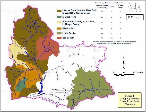
Table 1 shows the cropping distributions obtained from the cited sources. Figure 1 shows the regions to which these patterns can be applied, with percentages rounded to the nearest whole number.
Table 1 - Green River Basin Cropping Patterns, by Sub-Basin
Big Sandy/Eden Valley:
| Acres | ||||||||
| Other Hay | Alfalfa | Irr. Pasture | Sileage | Oats | Corn | Barley | Total | |
| 1989 | 5,971 | 1,997 | 1,390 | 125 | 140 | 0 | 70 | 9,693 |
| 1990 | 6,545 | 2,083 | 1,609 | 0 | 152 | 0 | 65 | 10,454 |
| 1991 | 8,514 | 2,611 | 1,581 | 96 | 0 | 378 | 48 | 13,228 |
| 1992 | 9,301 | 2,751 | 2,057 | 96 | 0 | 0 | 15 | 14,220 |
| 1993 | 10,073 | 2,954 | 2,057 | 96 | 0 | 0 | 34 | 15,214 |
| 1994 | No Report | NR | ||||||
| 1995 | 10,153 | 3,274 | 2,040 | 96 | 120 | 0 | 60 | 15,743 |
| 1996 | 7,877 | 5,672 | 2,040 | 96 | 160 | 0 | 74 | 15,919 |
| 1997 | 6,820 | 5,345 | 3,298 | 96 | 220 | 0 | 320 | 16,099 |
| 1998 | 6,406 | 5,640 | 3,298 | 96 | 290 | 0 | 580 | 16,310 |
| 1999 | 6,960 | 4,420 | 3,298 | 96 | 360 | 0 | 640 | 15,774 |
| Total | 78,620 | 36,747 | 22,668 | 893 | 1,442 | 378 | 1,906 | |
| Avg | 7,862 | 3,675 | 2,267 | 89 | 144 | 38 | 191 | 14,265 |
| % | 55% | 26% | 16% | 1% | 1% | 0% | 1% | |
Southwest Green River River Basin:
| Acres | ||||
| Grass Hay | Alfalfa | Grain | Total | |
| Blacks Fork | 25,266 90.2% |
2,297 8.2% | 442 1.6% |
28,005 |
| Smiths Fork | 10,107 96.0% |
322 3.1% | 100 0.9% |
10,529 |
| Henrys Fork | 7,251 100% |
0 | 0 | 7,251 |
Little Snake River Valley:
| Grass Hay | Alfalfa | Irr. Pasture | Total |
| 75% | 11% | 14% | 100% |
Lincoln County (Hams Fork, Fontenelle Creek, LaBarge Creek):
| Grass Hay & Pasture | Alfala | Total |
| 95% | 5% | 100% |
Upper Green River Basin:
The Upper Green River Basin contains some alfalfa fields under center-pivot installations. However, the aggregated acreage is so small that no appreciable error is introduced if the entire upper basin is assumed to be grass hay and pasture.
References
Annual Crop Production and Water Utilization Data, 1989-1999, Eden Valley Irrigation and Drainage District.
Grasmick, Tami, Program Technician, Uinta County USDA Service Center, April 2000, Personal Communication.
Kennington, Jody, District Conservationist, USDA, NRCS, Star Valley Office, April 2000, Personal Communication.
Western Water Consultants, December 1992, Little Snake River Basin Planning Study, Volume III, Irrigation Reservoir Investigations. Prepared for the Wyoming Water Development Commission.
Wyoming Water Planning Program, September 1970, "Water and Related Land Resources of the Green River Basin, Wyoming," Wyoming Water Planning Program Report No. 3, Wyoming State Engineer's Office.