Wyoming State Water Plan
Wyoming State Water Plan
Wyoming Water Development Office
6920 Yellowtail Rd
Cheyenne, WY 82002
Phone: 307-777-7626

Wyoming Water Development Office
6920 Yellowtail Rd
Cheyenne, WY 82002
Phone: 307-777-7626


Project Scope
The Green River Basin Water Planning Process document is second of two River Basin Plans compiled under initial efforts of the Wyoming Water Development Commission, and authorized by the Wyoming Legislature in 1999. The plan for the Bear River Basin is the first. Subsequent years will see plans developed for the northeast part of the State (Little Bighorn, Tongue, Powder, Little Missouri, Belle Fourche, Cheyenne, and Niobrara Rivers), Big Horn/Wind, Snake/Salt, and Platte River Basins. It is the express desire of the program to revisit and update the basin planning documents every five years.
This planning document presents current and proposed (estimated) future uses of water in Wyoming's Green River Basin. Uses to be inventoried include agricultural, municipal, industrial, environmental, and recreation. Surface and groundwater uses are both described as is overall water quality. Given current uses, the availability of surface and ground water to meet estimated future requirements is analyzed. To lay the groundwork for future water development, a review of the current institutional and legal framework facing such projects is presented. Finally, thoughts are given to guide implementation of the water planning process.
The Final Report is designed to present findings in enough detail to explain the overall plan without deluging the reader in technical minutiae. Separate Technical Memoranda provide technical details, methods, and selected references.
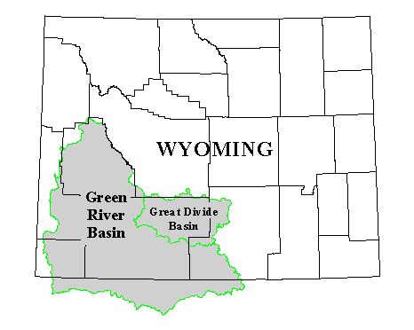
Basin Description
The Green River Basin consists of lands in Wyoming, Colorado, and Utah that drain to the Green River, the largest tributary of the Colorado River. The Wyoming portion of the Basin comprises nearly 25,000 square miles in Sweetwater, Sublette, Carbon, Lincoln, Uinta, and small areas in Fremont and Teton counties. For purposes of this plan, the Great Divide Basin is included, though this region does not contribute any run-off to the Green River.
Climate throughout the Basin varies, but generally follows the pattern of a high desert region. Precipitation data are available for about a dozen Weather Service stations in the Basin for the past 30 years. Various climatological factors combine to create a relatively short growing season throughout the Basin.
In addition to Flaming Gorge Reservoir, major water bodies include the Green River Lakes, New Fork Lake, Willow Lake, Fremont Lake, Halfmoon Lake, Burnt Lake, Boulder Lake, Big Sandy Reservoir, Eden Valley Reservoir, Fontenelle Reservoir, and numerous high mountain lakes in the Wind River Range in the central and eastern part of the Basin. In the western part of the Basin are Viva Naughton and Kemmerer No. 1 Reservoirs. To the south, Meeks Cabin and Stateline Reservoirs serve various Wyoming users, although Stateline is located entirely in Utah.
Major tributaries to the Green River include the New Fork, East Fork, and Big and Little Sandy Rivers in the northeast; the Little Snake River in the southeast; the Hams Fork, Blacks Fork and Henrys Fork of the Green in the southwest; and the Piney, LaBarge, Fontenelle, Cottonwood and Horse Creeks (among others) in the north and west.
Colorado River Management
The Green River of Wyoming is the major tributary to the Colorado River, one of the most physically controlled and institutionally managed rivers in the world. It drains the largest river basin in the United States save the Mississippi. Prone to flooding and needed for irrigation, the river came under the control of several major dams in the 20th century. Management of these structures, of the water in the river, and the distribution of the water for various needs has resulted in a regulatory and legal framework now known as the "Law of the River."
Of the several documents which comprise the Law, Wyoming's ability to develop and consumptively use water in the Green River Basin primarily is constrained by the two interstate Compacts, the Colorado River Compact of 1922, and the Upper Colorado River Basin Compact of 1948.
The States of the Upper Basin (Colorado, Utah, New Mexico, and Wyoming) allowed development to begin by establishing a division of the water through the Upper Colorado River Basin Compact, which followed the format of and was subject to the provisions of the original Colorado River Compact. This Compact among the upper basin states apportioned 50,000 acre-feet of consumptive use to Arizona (which contains a small amount of area tributary to the Colorado above the Compact point at Lee Ferry) and to the remaining states the following percentages of the total quantity available for use each year in the upper basin as provided by the 1922 Compact (after deduction of Arizona's share):
Colorado = 51.75 percent; Utah = 23.00 percent; New Mexico = 11.25 percent; Wyoming = 14.00 percent.
Using these percentages and best-case assumptions, the probable long-term available water supply for Wyoming from the Green River and its tributaries is 833,000 acre-feet per year.
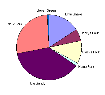
Water Storage
The Basin contains approximately 212,000 acre-feet of storage primarily devoted to supplemental irrigation supply. Some irrigated areas are well served by one or several reservoirs above them while others are devoid of storage of any size. The following chart depicts the relative availability of storage for irrigation in the sub-basins:
Current Water Use Summary
The major water uses are summarized in the following chart:
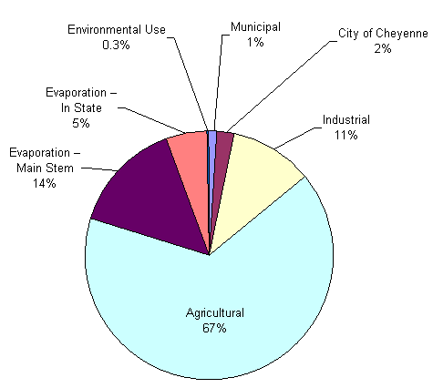
Total Use = 611,700 Acre-feet per Year
The Green River Basin of Wyoming is primarily a producer of forage for livestock. By far the most common use of irrigation is in the growth of grass hay for harvest and pasture. Alfalfa is grown in areas where the growing season and water supplies allow. Small grains and cash crops are very limited in extent.
Water supply and growing season are the factors most often given for the predominance of grasses under irrigation. In this sense, irrigated agriculture is tied very closely to the livestock industry because the only viable use for the hay is as forage. Typically the forage is used by the producers' herds although some is disposed through local sale or export from the Basin.
The depletion of water by irrigation is estimated, in general terms, using available water supply, the consumptive demand of the crops irrigated and the number of irrigated acres in the Basin. These depletions, or "consumptive use" estimates are useful for evaluating the overall use of water in the Basin relative to Compact allotments, the location of use relative to water supplies, and the relative amounts of the varying uses when growth is considered.
Municipal and Domestic Use
Nine municipalities in the Basin obtain their primary water supply from surface water while six municipalities use groundwater supplies. Domestic use is typically provided by ground water and is on the order of 1,900 to 3,900 acre-feet per year in the Green River Basin.
Industrial Use
Power plants including the Jim Bridger and Naughton Power Plants are the largest industrial water users in the Basin. Soda Ash Production is the second largest. Industrial groundwater use, largely a by-product of the petroleum or coal extraction process, is a small percentage of overall industrial water use.
Recreational Use
Recreational uses, generally non-consumptive uses, include boating, fishing, waterfowl hunting, and maintenance of wild and scenic rivers. In addition, information regarding visitation to the Fort Bridger Historic Site indicates that one in four visitors intend some water-based recreation at that location or elsewhere during their trip.
Environmental Use
Environmental Uses are also typically non-consumptive and include instream flows and reservoir bypasses, minimum reservoir pools and channel maintenance flows, maintenance of wetlands, riparian habitat, and other wildlife habitat, and direct wildlife consumption.
Evaporation
Evaporation from reservoirs constructed by man is a consumptive use associated with the beneficial use of water for other purposes and is counted as part of Wyoming's allocation under the Upper Colorado River Basin Compact.
Available Surface Water
For each Green River sub-basin, three models were developed, reflecting each of three hydrologic conditions: dry, normal, and wet year water supply. Streamflow, consumptive use, diversions, irrigation return flow patterns, and reservoir conditions are the basic input data to the model. Model output includes a comparison of historical and estimated diversions, and streamflow at specific model nodes in the Green River Basin for each of the dry, normal, and wet hydrologic conditions.
The results denote physical availability over and above existing uses, which is to be distinguished from legal or permitted availability; the models do not explicitly account for water rights, appropriations, or Compact allocations, nor is the model operated based on these legal constraints. Physical availability of water is the important first step in assessing the viability of any future water development project.
The tabulations show annual available supply at the bottom of the system for each basin as follows:
| Annual Available Supply (acre-feet per year) | |||
| Basin | Dry Condition | Normal Condition | Wet Condition |
| Little Snake | 189,000 | 449,000 | 665,000 |
| Henrys Fork | 23,000 | 60,000 | 125,000 |
| Blacks Fork | 101,000 | 229,000 | 422,000 |
| Green River | 620,000 | 1,269,000 | 1,924,000 |
Input to the models can be modified in order to estimate impacts associated with various water projects.
Available Ground Water
Groundwater resources of the Basin are largely undeveloped at this time. Consequently, sparse information is available to evaluate groundwater characteristics and development prospects in the Basin.
Ground water is principally used for drinking water supplies and industrial use. The majority of the supplies are developed from Quaternary and Tertiary aquifers. Current groundwater use within the Greater Green River Basin is estimated at 5,300 to 7,200 acre-feet per year
The majority of the study area is underlain by rocks that are host to several important aquifers, including the Frontier aquifer (western part of the Basin), the Mesaverde aquifer, and the Tertiary aquifer system.
Various estimates of groundwater recharge by precipitation derive a potential basin groundwater yield between 50,000 and 100,000 acre-feet per year. Thus, there is no evidence to suggest over-development of the principal aquifer systems. It may be concluded that there is significant potential for additional development of these aquifer systems, with little risk of depleting this resource.
There are many factors that may affect future development and availability of groundwater resources. In the case of alluvial aquifers, any future development of groundwater resources may be expected to have a direct and near-immediate impact on the adjacent rivers and streams within the alluvial system. The quality of water extracted as a by-product of potential coal bed methane (CBM) development in the Basin is reported to be significantly worse than in the Powder River Basin. Limitations imposed by Interstate Compact on the quality of water discharged to the Green River may require that the co-produced water be treated or reinjected. The impacts of the added costs of treatment or reinjection are unclear, but may render some CBM projects uneconomical. At this time, it appears unlikely that the level of development of CBM resources in the Greater Green River Basin will match the levels of development anticipated in the Powder River Basin given current market and environmental conditions.
Demand Projections Summary
For assessing the need for water into the future, this plan has developed estimates of water demand for each major use category out to year 2030. A summary of all projected uses is provided in the following table. Values are acre-feet per year:
| Type of Surface Water Use | Current (Normal Year) Use | Projected Growth Scenario | ||
| Low | Moderate | High | ||
| Municipal | 6,500 | 6,600 | 8,100 | 10,100 |
| City of Cheyenne | 14,400 | 22,700 | 22,700 | 22,700 |
| Industrial | 66,500 | 78,000 | 106,400 | 166,300 |
| Agricultural | 401,000 | 408,000 | 423,000 | 438,000 |
| Evaporation (in-State) | 32,800 | 32,800 | 32,800 | 32,800 |
| Recreation | non- consumptive | |||
| Environmental | 2,000 | 10,000 | 17,000 | 24,000 |
| Total | 523,200 | 558,100 | 610,000 | 693,900 |
| Percent of Compact Allocation | 63% | 67% | 73% | 83% |
| Main Stem Evaporation Charge (Full Development) | 88,500 | 72,800 | 72,800 | 72,800 |
| Grand Total | 611,700 | 630,900 | 682,800 | 766,700 |
| Percent of Compact Allocation | 73% | 76% | 82% | 92% |
Agricultural Use Projections
Future demands for additional irrigation water in the Green River Basin are largely dependent upon factors that might either increase the returns that Basin irrigators receive from irrigation or reduce the cost to them of developing new storage. Possibilities for increasing economic returns to irrigated agriculture in the Basin include diversifying cropping patterns into higher valued crops, the possibility that hay prices may rise to the point that it would be profitable to export hay from the Basin to other domestic markets, the possibility that cattle prices may rise significantly over the next 30 years, and an increase in the amount of financial assistance available to producers for reservoir construction from State and federal agencies.
The types of hay expected to be in high demand in the future are alfalfa for dairies and Timothy hay for horses. If future market prices for these crops stabilize at levels of well over $100 per ton, it may become practical for Green River Basin producers to develop additional storage and expand production of these crops for export markets.
Municipal/Domestic Use Projections
Three methods of producing population forecasts were evaluated. The Division of Economic Analysis of the Wyoming Department of Administration and Information produces population forecasts based upon time series data from which growth rates are derived from variables such as population, sales tax collections, and school enrollments. Second, the United States Census Bureau periodically produces population forecasts using mortality rates, fertility rates, and migration patterns. A third set of population projections assumes that the area would experience a total population increase during the period from 2000 to 2030 that is of the same magnitude that occurred during the 30-year period from 1960 to 1990.
Projections were made using high, moderate, and low growth scenarios. Current municipal and domestic water consumption rates were applied to population projections to estimate a potential increase of future municipal and domestic use of 40 to 60 percent.
Industrial Use Projections
The largest industrial water uses in the Basin involve electric power generation and soda ash production. Future water needs for electric power production in the Basin will be largely determined by how electric utilities in the Basin and elsewhere in the west respond to growing demands and various actions and proposals to deregulate the industry. Scenarios for possible industry responses to deregulation are not easily developed. Similarly, future growth prospects for the soda ash industry are largely dictated by the ability of Wyoming producers to capture an increasing share of the international market in the face of volatile international economic conditions and the protective tariffs imposed by some foreign countries.
Under a low growth scenario, surface water requirements for large industrial water users may increase by as little as 17 percent. A moderate growth scenario projects a reasonably foreseeable increase of 68 percent, while a high growth scenario projects an increase of 150 percent.
Recreation Use Projections
According to the Wyoming Game and Fish Department, the Green River could provide an annual supply of nearly 1,122,800 activity days of lake and reservoir fishing opportunities. When contrasted with the current rate of about 485,000 activity days of use annually, there is presently no apparent shortage of still water angling opportunities in the Basin.
A different conclusion applies to the Basin's stream fisheries. In 1988, the Wyoming Game and Fish Department estimated a total supply of about 411,000 angler days of stream fishing opportunities available in the Basin, but only about 213,000 angler days of this supply were in areas where public access was guaranteed. That figure contrasts with a current estimated annual use of about 300,000 angler days of activity, and projected demands in the range of 327,000 to 566,000 angler days of activity by the year 2030. These estimates indicate that the Basin's stream fisheries are already at capacity, and will come under increasing pressure in the future as its population increases and tourism related fishing pressure grows.
Environmental Use Projections
Environmental water requirements are not necessarily related to changes in population or tourism in the Basin. Instead, environmental water requirements are at least partially a function of human desires concerning the type of environment in which people want to live. These desires are expressed through environmental programs and regulations promulgated by elected representatives at the state and federal levels. Thus, future environmental water requirements in the Green River Basin will be determined, at least partially, by existing and new legislation dealing with environmental issues at the state and federal levels, and how that legislation is implemented by federal and state agencies.
Wyoming's instream flow statutes recognize such non-consumptive flows not only contribute to aesthetic character and biological diversity of the Basin, they also support recreational fisheries that are important to Basin residents and to the Basin's economy. Five reservoirs in the Basin have "fish" or "fish and wildlife" uses listed in their permitting documents: Big Sandy, Boulder, Flaming Gorge, Fontenelle, and High Savery. Given the current federal regulatory environment and the desires of the public to maintain and enhance recreational fisheries in the Basin, it is likely that any additional storage developed in the future will have a provision of minimum reservoir pools for fish and wildlife purposes.
Water Development Needs and Opportunities
Considering consumptive uses of water, only the agriculture sector experiences current shortages. Predictably, these shortages are in areas not already served by storage to any significant extent. Unfortunately, the main reason these shortages exist is that agriculture is the economic sector least able to afford the high cost of storage construction. This is especially true for those operators focused upon raising forage instead of cash crops, to provide late season supplemental supplies.
Therefore, the general direction taken for recommending future use opportunities focused largely on providing supplemental irrigation supplies. Multiple use opportunities were also considered because the effects of the various projects on environmental and recreational values (including funding) are very important and can result in otherwise similar projects being viewed quite differently.
Nine previously completed planning studies, new project ideas suggested by Basin Advisory Group (BAG) members, and an initial screening of clearly unfeasible or unlikely candidates provided over 45 projects to review for potential application to current and future needs. Groundwater development and conservation opportunities, such as conversion to sprinkler irrigation or canal rehabilitation, were also evaluated on a regional (sub-basin) basis.
Based upon comments received during BAG meetings, review of previously published criteria and questionnaire results, and the Scope of Services, a procedure for screening opportunities for future water use was developed. The procedure included a prioritization based on need, and evaluative criteria based on favorability. Projects were initially prioritized according to the following schedule:
| Priority | Description |
| 1 | Rehabilitation projects that preserve existing uses and economic dependencies. |
| 2 | Projects that rectify existing demands/needs/shortages. |
| 3 | Projects that meet projected future demands/needs shortages. |
| 4 | Trans-basin diversions of water that enhance in-state uses. |
Six criteria under each of these priorities aim to present an overall picture of the favorability of a project. These include factors ranking water availability, financial feasibility, public acceptance, number of sponsors/beneficiaries/participants, legal/institutional constraints, and environmental/recreational benefits.
The Green River Basin Plan provides detailed strategies for coping with institutional and financial constraints on water project development.
Future Water Plan Directives
This document is intended to be used as a reference for citizens of the State of Wyoming and agency personnel to understand the current state of water use and development in Wyoming's Greater Green River Basin. It will be available to legislators as background material when evaluating future water development funding decisions. It can be referred to for assistance in establishing purpose and need for future water development project work. Agency personnel will, upon critical review and with experience from its use, find areas to be more closely evaluated in subsequent updates.
The Wyoming Water Development Commission, the state revolving fund for water treatment facilities, federal assistance through the USDA Rural Development Program and various conservation programs (e.g. the Conservation Reserve Program and Wildlife Habitat Incentives Program) all provide water development assistance for municipalities, irrigation districts, and individuals to perform necessary and valuable work that they otherwise could not afford. Because water development in the form of water treatment improvements and environmental enhancements are desirable goals, these programs are vital to the overall quality of life in the Basin.
Water development has become difficult and costly. However, if a project proponent has a need for water, patience, and financial resources, the federal permitting process can be successfully completed. Wyoming must maintain its resolve to develop its water resources to meet the needs of its citizens.
The publication of the Green River Basin Planshould foster discussion among water users and state officials relative to water development in the Green River Basin in Wyoming. The plan concludes that Wyoming has water to develop in the Basin. The water can be used for future municipal and industrial growth. There are existing agricultural water demands that could be met with the water.
As long as Wyoming has water to develop in the Green River Basin, there will be debate regarding the sale or lease of water to downstream interests. Storage water or other supplies that can be delivered on demand may offer revenue potential for the State.
The Green River Basin Plan is an important step towards identifying and achieving Wyoming goals in the Green River Basin. It is important to update and maintain the Green River Basin Plan or it will simply be a glimpse of the status of the water use at the end of the twentieth century. In order to improve on the plan, additional data will be necessary, and the understanding of existing water use must be maintained or improved.