| ||||||||||||||||||||||||||||||||||||||

| Home Page News & Information River Basin Plans Basin Advisory Groups Planning Products |
TECHNICAL MEMORANDUM
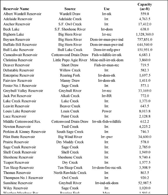
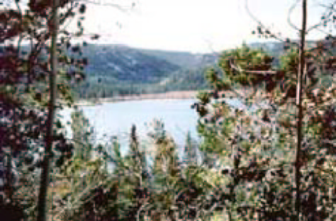
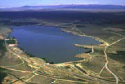
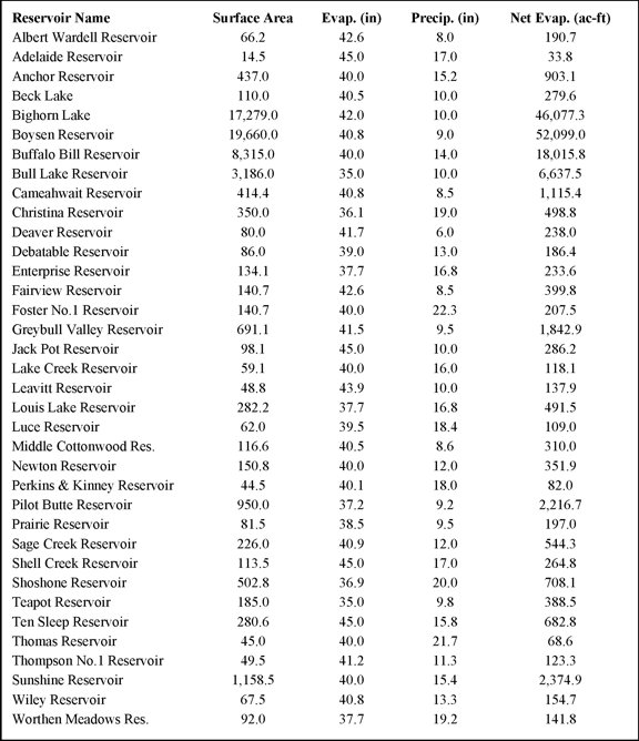
Major Reservoir Information The Wind – Big Horn River Basin contains several large reservoirs used for various purposes including storage for irrigation, municipal, industrial, recreation, fish propagation, and flood control. Various federal, tribal, and private interests own the reservoirs described in this memorandum. For purposes of the Wind – Big Horn River Water Plan, reservoirs having storage capacity of 500 AF or greater are the focus of this analysis. Table 12-1 identifies the reservoirs that are considered in the surface water assessment presented as part of the Wind – Big Horn River Basin Plan and the location of these reservoirs is shown on Figure 12-1 Reservoir Descriptions Albert-Wardell Reservoir Albert-Wardell Reservoir is located in Big Horn County. The reservoir is supplied by Wardell Draw, a tributary to Dorsey Creek which is tributary to the Greybull River. The reservoir also receives water from Dorsey Creek through the Albert Wardell Supply Ditch. It has a priority date of December 24, 1954 and supplies water for stock and irrigation use. Adelaide Reservoir Adelaide Reservoir is located in Big Horn County near the Sheridan and Johnson county lines. Water for storage is supplied by Adelaide Creek which is tributary to Shell Creek. The reservoir also receives water from Buckley Creek through the Adelaide Supply Ditch. Water stored in the reservoir is used for irrigation purposes and the priority date is August 8, 1910. It is also the one of the few unadjudicated reservoirs considered in the surface water evaluation. Anchor Reservoir Anchor Reservoir is located in Hot Springs County, west of Thermopolis, near the Fremont County line. The reservoir was constructed by the Bureau of Reclamation in a narrow gorge on the South Fork of Owl Creek, a tributary of the Bighorn River. The reservoir does not have an adjudicated water right. Water stored in the reservoir is utilized for irrigation and the reservoir has a priority date of December 18, 1933. Because of a leakage problem, this reservoir has never achieved its design capacity. Table 12-1 – Reservoirs with Greater than 500 ac-ft of Storage Capacity
Wyoming State Engineer’s Office reservoir permits were used to develop information presented in Table 12-1 Beck Lake is located in Park County, south of Cody, off Highway 120. It is an off-channel reservoir with a capacity of 623 acre-feet. The lake is filled via the Cody Canal which draws its water from the South Fork of the Shoshone River. Water is utilized primarily for irrigation though there maybe a minimal amount of domestic use associated with lawn irrigation. The reservoir has an adjudicated water right and a priority date of July 24, 1908. Big Horn Lake Big Horn Lake is a Bureau of Reclamation project located on the Big Horn River near the Wyoming – Montana border. Yellowtail Dam, named for the famous Crow Indian chairman, Robert Yellowtail, is located in Montana was completed in 1961. Big Horn lake is 60 miles long and stores water for irrigation, power production, and recreation. No Wyoming water right appears to have been issued for this reservoir due to the dam location. Boysen Reservoir Boysen Reservoir is a Bureau of Reclamation (BOR) project located on the Wind River just north and west of Shoshoni. The reservoir surface area is approximately 20,000 acres with approximately 77 miles of shoreline. Primary beneficial uses of reservoir storage are irrigation and power production. The Town of Thermopolis has a water service contract with the BOR for delivery of up to 1,200 acre-feet of Boysen storage to supply the municipal and irrigation needs of the town and other entities served by the town’s distribution system. Boysen Reservoir has an adjudicated water right and the initial priority date is October 22, 1945. Storage of water behind Boysen Dam initiated in October 1951, but the dam was not completed until December 11, 1952. The total storage capacity is 892,226 acre-feet at elevation 4732.2 feet (top of flood control).
Buffalo Bill Reservoir Buffalo Bill Reservoir is a Bureau of Reclamation (BOR) project located approximately six miles west of Cody. The Buffalo Bill Dam, constructed between 1905 and 1910 was one of the first high concrete dams to be built in the United States. It has an adjudicated water right with a priority date of March 5, 1904. In 1994, the BOR completed modifications to the dam and Powerplant complex. The Shoshone Municipal Joint Powers Board has a water service contract with the BOR for 9,725 acre-feet of water. On average, the BOR delivers approximately 2,800 acre-feet to the Shoshone Municipal Pipeline. This pipeline serves the majority of the cities and towns in the northern portion of the Big Horn Basin. The remaining storage volume is utilized for irrigation, power generation, and industrial use.
Bull Lake Bull Lake is a Bureau of Reclamation project located in the Wind River Indian Reservation, approximately 30 miles northwest of Lander. The reservoir has a capacity of 151,951 acre-feet. The source of supply is Bull Lake Creek, a tributary to the Big Wind River and it has an adjudicated water right with a priority date of December 26, 1906. The primary uses of water are for agriculture and hydro-power with a very minimal amount of water being utilized for domestic purposes. Cameahwait Reservoir Cameahwait Reservoir is a Bureau of Reclamation project located within the Wind River Indian Reservation, west of Boysen Reservoir. It has an approximate capacity of 6,683 acre-feet. The primary use of the reservoir is for fish propagation, recreation, and wildlife; irrigation is secondary with only 805 acre-feet of storage being allocated for this purpose. The source of supply is Cottonwood Drain, a tributary of Muddy Creek, which is tributary to the Wind River. The reservoir has an adjudicated water right with a priority date of January 29, 1973. Christina Reservoir Cristina Reservoir is located in Fremont County within the headwaters of the Little Popo Agie River. The initial 1,200 acre-foot filing for the reservoir is associated with a territorial water right with a priority date of September 1888. Subsequent to the initial filing, there were two were two enlargements granted for 1,252.25 acre-feet and 1,407.75 acre-feet, respectively. The enlargements have priority dates of July 20, 1935 and September 2, 1939 and all rights are adjudicated. Water from the reservoir was originally diverted through the Christina and Gustave Lake Ditch to the Rock Creek drainage, a tributary of the Sweetwater River, and used for mining and milling operations at Atlantic City. Today a small volume of the stored water is used for domestic purposes. Deaver Reservoir Deaver Reservoir is located in Park County, west of the Town of Deaver. Water supplied to the reservoir is diverted from the Shoshone Reservoir at Corbett Diversion Dam and flows through the Garland and Frannie canals to Lateral 114-F, which discharges into the reservoir. Another source of water to the reservoir is Short Draw, a tributary to the Shoshone River. Stored water is primarily used for irrigation and fish propagation. At one time the reservoir was part of the municipal supply system for the Town of Deaver. Today, the Shoshone pipeline serves all of Deaver’s culinary use and the reservoir supplies approximately 125 acre-feet for town’s irrigation needs. Debatable Reservoir Debatable Reservoir is located within the Wind River Indian Reservation near the Fremont – Hot Springs county lines. The reservoir is in the Willow Creek drainage, a tributary of Muddy Creek which is tributary to the Wind River. Water stored is supplied to the Hosie Ditch No. 2 for irrigation during the summer months. The reservoir has an adjudicated water right with a priority date of September 16, 1910.
Enterprise Reservoir Enterprise Reservoir, also known as Frye Lake, is located in the Shoshone National Forest within Fremont County. Water is supplied to the reservoir from Townsend Creek, a tributary to Saw Mill Creek and Roaring Fork Creek which are both tributary to the Middle Fork of the Popo Agie River. The reservoir has an adjudicated water right with an initial priority date of August 30, 1933. Subsequent to the initial filing, there were two enlargements which occurred in the 1939 (after completion of construction) and a second in June, 1965 giving the reservoir a storage capacity of 1,697 acre-feet. Water from the reservoir is primarily used for irrigation and stock purposes by members of the Enterprise Irrigation Company. A small amount of water is used as domestic supply. Fairview Reservoir Fairview Reservoir is located in Big Horn County, south of Burlington. Water is supplied to the reservoir from Manny Draw and the Fairview Canal which diverts water from the Greybull River. According to the original application filed with the SEO, the designated beneficial uses of the water are irrigation, stock water and domestic use. Discussions with SEO District III personnel indicate that there is no domestic use of the stored water. The reservoir has an adjudicated water right with a priority date of December 7, 1934. Foster No. 1 Reservoir Foster No. 1 Reservoir is located northwest of Meeteetse, just inside Shoshone National Forest Boundary. Water for storage is supplied from two sources: (1) Sage Creek which is tributary to the Shoshone River and (2) Foster Draw a tributary to Meeteetse Creek which is tributary to the Greybull River, via the Foster Supply Ditch No.1. The reservoir supplies irrigation water to lands irrigated from the Joe Moss, Horse Creek, and Long Hollow Ditches. Through time, the reservoir has undergone two enlargements, one in 1951 and a second in 1953, bringing the capacity of the reservoir up to 573.1 acre-feet. The reservoir has an adjudicated water right with an initial priority date of November 2, 1935. Greybull Valley Reservoir Greybull Valley Reservoir is located in Park County, approximately 12 miles southwest of Burlington. The reservoir is located in Red Clay Draw which is a tributary of the Greybull River. Water is supplied to the reservoir via the Greybull Valley Reservoir Supply Canal which diverts water from the Greybull River, approximately four miles upstream from the reservoir inlet. The reservoir was built as part of a Wyoming Water Development Commission project and completed in 2000. The priority date of the reservoir is November 14, 1989. Jack Pot Reservoir Jack Pot Reservoir is located in Natrona County, north of Arminto. The reservoir’s source of supply is Alkalai Creek, a tributary to Badwater Creek which ultimately flows into Boysen Reservoir . The Chicago, Burlington, and Quincy Railroad Company owns the reservoir and the stored water is used for purposes associated with railroad operations. Reservoir storage capacity for the original filing on January 4, 1911 was 482 acre-feet and an enlargement of 290 acre-feet was filed in December of 1912. The reservoir has an adjudicated water right. Lake Creek Reservoir Lake Creek Reservoir is located in Hot Springs County, approximately 15 miles west of Hamilton Dome. Water is used for irrigation purposes and is supplied to the reservoir from Lake Creek, a tributary to Cottonwood Creek which is tributary to the Big Horn River. The original filing on October 1, 1935 with the SEO listed a capacity of 1,240.3 acre-feet and a 132.7 acrre-foot enlargement was filed on October 31, 1936. Water rights associated with reservoir are adjudicated. Leavitt Reservoir Leavitt Reservoir is located in Big Horn County, north of Shell. Water for storage is supplied from Beaver Creek and Davis Draw via the Leavitt Supply Ditch drainage, both of which are tributary to Shell Creek. Water stored in the reservoir is associated with lands irrigated by the Trout, Calvin, Tolen, and Bernie Ditches. The reservoir has an adjudicated water right with a priority date of April 9, 1954. Louis Lake Reservoir Louis Lake Reservoir is located in Fremont County within the Shoshone National Forest. The lake is fed by Louis Creek, a tributary of the Little Popo Agie River. A petition for a water right was filed with the SEO with the intended purpose of power generation and was assigned a priority date of January 6, 1926. It is presumed the intended purpose was to supply power to surrounding mining operations. The right was never adjudicated and was cancelled on January 14, 1988.
Luce Reservoir Luce Reservoir is located in Park County, approximately 10 miles south of the community of Clark. Water is supplied to the reservoir by Paint Creek, a tributary of the Clarks Fork River. Water stored in the reservoir is used to irrigate lands supplied by the Luce Ditch. The reservoir has an adjudicated water right with a priority date of August 7, 1905. Middle Cottonwood Reservoir Middle Cottonwood Reservoir is a Bureau of Reclamation project located in Wind River Indian Reservation. Water is supplied to the reservoir via Cottonwood Drain Draw, a tributary of Muddy Creek which discharges into Boysen Reservoir. Reservoir storage capacity equals 612 acre-feet of which 260 acre-feet is allocated for irrigation and the remaining 352 acre-feet is utilized for stock, fish, wildlife, and recreation purposes. The reservoir has an adjudicated water right with a priority date of January 29, 1973. Newton Reservoir Newton Reservoir is located in Park County, approximately 4 miles west of Cody. Trail Creek, a tributary to the Shoshone River is reservoir’s source of supply. Water stored in the reservoir is used supply irrigation water to the Newton Reservoir Supply and Breteche Ditches. The reservoir has a territorial water right with a priority date of February 7, 1898. Perkins and Kinney Reservoir Perkins and Kinney Reservoir is located in Park County, south of Cody. Water is supplied to the reservoir by South Sage Creek, a tributary Sage Creek which is tributary to the Shoshone River. Reservoir storage is used to supply the Edgar Ditch with irrigation water. The original SEO filing for 350 acre-feet occurred on October 4, 1893. On September 16, 1907 an enlargement was filed for 396 acre-feet. All rights associated with this reservoir are adjudicated. Pilot Butte Reservoir Pilot Butte Reservoir is a Bureau of Reclamation project located in Fremont County. The reservoir is located off-channel and is supplied with water from the Big Wind River via the Wind River Diversion Dam. The canal supplying the reservoir has an initial capacity of 2,200 cubic feet per second and the drop between the diversion dam and the reservoir is utilized to produce electric power. The reservoir has an adjudicated water right with a priority date of August 8, 1906. Stored water is primarily used for irrigation although there is some power production associated with delivery of water to the reservoir.
Prairie Reservoir Prairie Reservoir is located in the Wind River Indian Reservation west of Boysen Reservoir. The reservoir is located off-channel and is supplied by an unadjudicated supply ditch that diverts water from Dry Muddy Creek, a tributary of Muddy Creek which drains into Boysen Reservoir. Stored water is used to supply the Muddy Prairie Basin Ditch with irrigation water. Water rights associated with the reservoir are adjudicated and have a priority date of October 16, 1911. Sage Creek Reservoir Sage Creek Reservoir is located in Park County, approximately 9 miles south of Cody. The reservoir is located off channel is supplied by the Sage Creek Pipeline. Sage Creek Pipeline diverts water from Sage Creek, a tributary of the Shoshone River, has an adjudicated right to divert a maximum of 3,805 acre-feet per year. The pipeline also supplies water to the Wiley Reservoir. Sage Creek Reservoir has an initial priority date of December 28, 1901 for 440 acre-feet. On September 26, 1979 an enlargement for 2,345 acre-feet was filed. . Water is utilized for irrigation and rights associated with the reservoir are adjudicated.. Shell Creek Reservoir Shell Creek Reservoir is located in the Big Horn National Forest near the Big Horn, Johnson, and Sheridan county lines. Water is supplied to the reservoir from Shell Creek, a tributary of the Big Horn River and is used for irrigation purposes. The reservoir has an adjudicated water right with a priority date is October 20, 1911. Shoshone Reservoir Shoshone Reservoir is located in the Shoshone National Forest within Fremont County. Shoshone Creek, a tributary to the North Fork of Popo Agie River is the reservoir’s sole supply source. The original filing for 2,386.4 acre-feet occurred on July 15, 1937. Subsequently, two enlargements for 2,172.9 and 5181.2 acre-feet, respectively, were filed on June 21, 1940 and July 30, 1958. The reservoir water rights are adjudicated with irrigation being the designated beneficial use. Teapot Reservoir Teapot Reservoir is located on the Wind River Indian Reservation, approximately 12 miles east of Crowheart. The reservoir is off-channel reservoir and supplied by the Teapot Supply Ditch which diverts water from Dry Creek, a tributary of the Big Wind River. Stored water is used to supply the Teapot Outlet and Hays Ditches with irrigation water. The reservoir has an adjudicated water right with a priority date of September 9, 1916. Tensleep Reservoir Tensleep Reservoir, also known as Meadowlark Lake, is located in Big Horn County, approximately 16 miles north east of Ten Sleep. Ten Sleep Creek, a tributary to the Nowood River supplies water to the reservoir. The US Forest Service is the appropriator and the reservoir is used primarily to supply water for irrigation, fire control, recreation, and a very minor amount is used for domestic purposes. The reservoir is adjudicated and with a priority date of January 31, 1938. Thomas Reservoir Thomas Reservoir is located in Park County, approximately 16 miles west of Meeteetse. Water is supplied to the reservoir from Little Rawhide Creek, a tributary of Rawhide Creek and Rawhide Ditch No. 1 (unadjudicated) which diverts water from Rawhide Creek, a tributary of the Greybull River. The original filing was for 40 acre-feet on September 25, 1900. Subsequently, two enlargements were filed, one on October 8, 1904 and the second on Augsust 7, 1919 for 58 and 756.5 acre-feet, respectively. Water is stored in the reservoir for irrigation under the Thomas and Pearce (Rawhide No. 3) Ditches. Water rights associated with the reservoir are adjudicated. Thompson Reservoir No.1 Thompson Reservoir No. 1 is located in Hot Springs County, west of the community of Red Lane. The reservoir is supplied by Owl Creek, a tributary of the Big Horn River. The original filing was for 326.3 acre-feet on December 4, 1907. On April 12, 1909 an enlargement for 593.9 acre-feet was filed. Reservoir storage is used to supply the Baylor and Purvis Ditch with irrigation water. Water rights associated with the reservoir are adjudicated. Sunshine Reservoir Upper Sunshine Reservoir is located in Park County, approximately 12 miles southwest of Meeteetse. Water for the reservoir is supplied by the Sunshine Supply Canal and Sunshine Creek which are tributary to the Greybull River. Water stored in the reservoir is primarily used for irrigation and industry with irrigation being the primary beneficial use. According to the SEO, approximately 20 acre-feet of stored water is used for domestic purposes. The reservoir has an adjudicated water right and an initial priority date of March 7, 1928. On April 3, 1940 an enlargement for 3,529.2 acre-feet was filed with the SEO for irrigation and industrial use. Wiley Reservoir Wiley Reservoir is located in Park County, approximately 10 miles south of Cody. Water is supplied to the reservoir via the Sage Creek Canal and the Sage Creek Pipeline which divert water from Sage Creek, a tributary of the of the Shoshone River. The original priority date for this reservoir is September 13, 1912 and an enlargement for 331 acre-feet was filed on October 16, 1969. The primary beneficial use of the water was irrigation, supplying the Wiley Ditch Number One. This ditch was voluntarily abandoned on July 15, 1983. Records filed with the SEO indicate that 14 acre-feet is being utilized for domestic purposes. Water rights associated with this reservoir are adjudicated. Worthen Meadows Worthen Meadows Reservoir is located in the Shoshone National Forest, approximately 15 miles southwest of Lander. The reservoir receives its water from Roaring Fork Creek, a tributary to the Middle Fork of the Popo Agie River. Water stored is used solely for municipal use by the City of Lander. The reservoir has an adjudicated water right with a priority date of October 7, 1954. Evaporation Evaporation from reservoirs is a consumptive use and when combined with beneficial uses, such as irrigation or municipal, is charged against Wyoming’s allocation under the Yellowstone River Compact. Under the compact, Wyoming’s share of the Clark’s Fork River is 60% and the Big Horn River, exclusive of the Little Big Horn River, is 80%. Article V(a) of the Compact states “Appropriative rights to the beneficial uses of the water of the Yellowstone River system existing in each signatory state as of January 1, 1950, shall continue to be enjoyed in accordance with the laws governing the acquisition and use of water under the doctrine of appropriation.” Article V, Part c of the Yellowstone River Compact states the following:
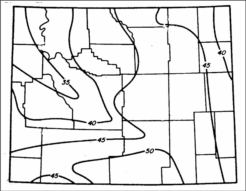
The above calculation would dictate that the evaporation losses from several large reservoirs in the Big Horn basin would be addressed in Compact allocation. These reservoirs include, Boysen, completed in 1952 (water storage, however, was initiated in October, 1951), Big Horn Lake, completed in 1966, and the entire series of reservoirs developed in the Cottonwood Drain (e.g. Lake Cameahwait and Middle Cottonwood Reservoir). To compute evaporation losses of each reservoir with a storage capacity of greater than 500 acre-feet, the Wyoming Climatic Atlas was utilized. Figure 12.2 of this text provides a map of mean annual lake evaporation adapted from Lewis, 1978. In order to distribute annual evaporative losses on a monthly basis, monthly evaporation data were obtained from the US Bureau of Reclamation’s web site for the Buffalo Bill and Boysen Reservoirs. These data were combined with the estimated monthly evaporation data for the City of Lander provided in Martner, 1986 to develop an average monthly distribution. Evaporation losses for each reservoir were estimated by plotting their location on the map of annual evaporation, determining an annual loss rate through means of linear interpolation, and establishing the monthly evaporative loss based on the derived distribution described above. The above process provided a reasonable estimate of the gross evaporative loss. To determine net evaporative losses, reservoir locations were plotted on a map of average annual precipitation, Lowham, 1988. Annual precipitation depth for each reservoir was determined by linear extrapolation. A monthly precipitation distribution was developed by obtaining average monthly precipitation depths, over a 30-year period, for 12 weather stations scattered across the project area. Monthly precipitation depth are determined by using the derived distribution to distribute the estimated annual precipitation depths for each reservoir. The distributions developed for monthly evaporation and precipitation are found in Table 2. Data describing the gross evaporation and precipitation as well as any available data on average End-of-Month (EOM) reservoir storage are found in Appendix A. Table 12-3 presents an estimate of the maximum net evaporation loss for each reservoir considered in the Wind – Big Horn River surface water model. Calculations for net evaporative loss are conservative as the surface area considered is equal to the high water line. Appendix B provides stage-storage curves for each reservoir by drainage basin. Table 12-2 Monthly Evaporation and Precipitation Distributions
Table 12-3 Annual Maximum Net Evaporative Loss
Figure 12-2 Annual Estimated Lake Evaporation (inches) after Lewis, 1978
References Lowham, H., 1988, Streamflows in Wyoming, US Geological Survey, Water Resources Investigation Report 88-4045. Martner, B, 1986, Wyoming Climatic Atlas, Wyoming Water Research Center, University of Wyoming, Laramie US Bureau of Reclamation, Reservoir Information available through the Internet University of Wyoming, Water Resources Data System. Wyoming State Statutes, Title 41 – Chapter 12 – Article 6 - Yellowstone River Compact |
|||||||||||||||||||||||||||||||||||||