Wyoming State Water Plan
Wyoming State Water Plan
Wyoming Water Development Office
6920 Yellowtail Rd
Cheyenne, WY 82002
Phone: 307-777-7626

Wyoming Water Development Office
6920 Yellowtail Rd
Cheyenne, WY 82002
Phone: 307-777-7626


| SUBJECT: | Wind/Bighorn River Basin Plan Available Ground Water Determination |
| PREPARED BY: | Mark E. Stacy and Chris Lidstone, Lidstone and Associates, |
| DATE: | January 14, 2003 |
A qualitative summary of the ground water resources of the Wind, Bighorn, Yellowstone, Clark.s Fork, Gallatin, and Madison River Basins of north central Wyoming is presented in this technical memorandum. Collectively, these basins and the study area are referred to as the Wind/Bighorn River Basin (planning area) in this memorandum. This memo summarizes the results of the work associated with the performance of Task 3E . Available Ground Water Determination for the Wind/Bighorn River Basin Plan. No original investigations were performed as part of Task 3E. The work consisted of performing an inventory, compilation, and review of published literature on the geology and ground water resources of the planning area.
Study Objectives
The first objective of Task 3E was to inventory and document existing published data on ground water studies and ground water planning documents for the planning area. The planning area encompasses a large area of Wyoming and includes the Wind River Basin, the Bighorn Basin, the Bighorn Mountains, the Wind River Mountains, the Owl Creek Mountains, the Absaroka Mountains, the Beartooth Mountains, and the Yellowstone Plateau. Most of the existing ground water studies and ground water planning documents are included in Appendix A and have considered the planning area with respect to either individual counties or as separate geographic areas such as the Wind River Basin, the Bighorn Basin, and the Yellowstone Plateau. While additional information on specific geographic areas within the planning area is available through the U.S. Geological Survey (USGS), the U.S. Bureau of Land Management (BLM), and other federal agencies, references included in Appendix A provide sources for an overview of ground water resources in the region.
A second objective of Task 3E was to inventory and catalog the Wyoming State Engineer's Office (WSEO) ground water permit database for various categories of ground water uses in the planning area, and incorporate the extracted information into four GIS data layers. This was accomplished through a cooperative effort of personnel of the WSEO and Wyoming Water Development Commission (WWDC). WWDC and TriHydro Corporation (TriHydro) established the format of the WSEO Data Query, and provided Lidstone and Associates, Inc. (LA) with the information. GIS data layers prepared from information on file with the WSEO as of December 31, 2001, are presented in Appendix B and include:
A third objective of this investigation has been to semi-quantitatively assess the impacts of well interference in more intensively developed ground water production areas near Hyattville and Riverton. The Wind River Aquifer near Riverton has been extensively developed primarily for municipal and domestic use. In the vicinity of Ten Sleep and Hyattville, the Tensleep, Madison, and Flathead Aquifers have been developed principally for agricultural use, but are also used for municipal and industrial purposes. These particular areas were investigated at the request of WWDC personnel to assess whether or not some form of ground water management designation may be warranted at this time.
Other objectives of Task 3E were as follows:
It is the intention that this memorandum, the GIS data layers, and the bibliography generated for this Basin Plan provide a starting point for site-specific ground water investigations.
Wind/Bighorn River Basin Overview
The planning area lies in the central and northwestern quarter of Wyoming and includes all or part of eight counties, and several major communities. The planning area includes all of Big Horn, Park, and Hot Springs Counties, about 95% of Washakie County, approximately 85% of Fremont County, and roughly 10% of Teton County. Also included are small, relatively undeveloped portions of northwestern Natrona and western Johnson Counties. Approximately 80% of Yellowstone National Park is included in the planning area. Major communities in Big Horn, Park, and Hot Springs Counties include: Thermopolis, Greybull, Lovell, Byron, Powell, Meeteetse, and Cody. Riverton, Lander, Dubois, and Shoshoni are the primary towns in Fremont County. Worland is the major community in Washakie County.
Regionally, the planning area lies within the Missouri River drainage system and covers an area of approximately 20,500 square miles of federal, state, and privately owned land in central and northwestern Wyoming. The principal river systems include the Wind, Bighorn, Clark.s Fork, Yellowstone, Shoshone, Greybull, and their respective tributaries. These drainage systems form the boundary of the basin.
Altitudes in the planning area are variable because the Wind River and Bighorn Basins are bordered by high alpine mountain ranges. Elevations range from roughly 3,500 feet above sea level where the Bighorn River crosses the State line into Montana in Bighorn County to 13,804 feet at the summit of Gannett Peak in Fremont County. Within the interiors of the Bighorn and Wind River Basins, elevations range from only 4,000 to 6,000 feet (Richter, 1981; Libra and others, 1981). Topographically, the Yellowstone Plateau in the northwestern corner of the planning area generally lies at higher elevations than the rest of the area, and generally ranges in elevation from 7,731 feet at Yellowstone Lake in Teton County to 12,244 feet at Trout Peak in Park County.
The climate of the planning area varies primarily as a function of altitude and ranges from semi-arid continental in the basin interiors to humid-alpine in the bordering mountain ranges. Annual precipitation varies from 6 to 8 inches in the basin interiors up to 60 to 70 inches along the peaks of the bordering mountain ranges (Libra and others, 1981; Richter, 1981). Annual precipitation in the vicinity of Yellowstone National Park ranges from 13 to 70 inches (Cox, 1976). Most of the planning area receives the majority of its precipitation during the winter as snowfall, but the basin interiors primarily receive precipitation during occasional spring and summer thunderstorms (Libra and others, 1981).
Geologic Setting
Encompassing approximately one quarter of the state, the planning area contains a wide variety of geologic formations and structural elements within the Wind River Basin, the Bighorn Basin, and the Yellowstone Plateau, as shown on Figure 1. Geologic formations vary in thickness and in age from Precambrian crystalline rocks to Recent alluvial and terrace deposits of silts, clays, sands, and gravels, as shown on Figure 2. The Wind River Basin contains roughly 18,000 feet of Cenozoic through Paleozoic sedimentary strata (Richter, 1981). Similarly, the Bighorn Basin contains approximately 33,000 feet of Cenozoic through Paleozoic sediments (Libra and others, 1981). In contrast, the Yellowstone Plateau and mountain ranges to the east contain at least 15,000 feet of Cenozoic volcanics and volcanic sediments that overlie Mesozoic and Paleozoic sedimentary rocks (Cox, 1976). Figures 3 and 4 present the general surficial and bedrock geology of the planning area.
The Wind River and Bighorn Basins are both large asymmetric structural depressions that contain up to 18,000 and 33,000 feet, respectively, of Cenozoic, Mesozoic, and Paleozoic sediments that rest unconformably on Precambrian crystalline basement rocks (Libra and others, 1981; Richter, 1981). With the exception of the western Bighorn Basin that is covered with Absaroka Volcanics, these structural basins are bordered by compressional uplifts cored by Precambrian granite and mantled by moderately to steeply dipping sedimentary formations (Libra and others, 1981). While it has been speculated that these or similar structures extend far into Yellowstone National Park, the Yellowstone Plateau coincides with a large volcanic caldera (Cox, 1976; Libra and others, 1981). Figures 5 and 6 present geologic cross sections of the Wind River and Bighorn Basins, respectively. The configuration of these geologic formations and structural elements greatly influences the occurrence and availability of ground water in the planning area.
Within the Bighorn and Wind River Basins, significant quantities of oil, gas, and uranium have been commercially developed from sedimentary rocks. Coal and bentonite have both been commercially developed within the Bighorn Basin. Most oil and gas in the region has been developed from Mesozoic and Paleozoic rocks in structurally sympathetic anticlines (Richter, 1981; Libra and others, 1981). The Wyoming Oil and Gas Conservation Commission (2000) reported approximately 20 million barrels of oil and 156 million cubic feet of natural gas were produced from 4,937 wells in Big Horn, Fremont, Hot Springs, Park, and Washakie Counties in 2000. Uranium has been produced from the Wind River Formation in the Wind River Basin.
Hydrostratigraphy
An aquifer is generally defined as a geologic formation or group of formations that are sufficiently saturated and permeable enough to yield a significant quantity of water to wells or springs. Of the more than 40 geologic formations that are present in the planning area, at least 12 aquifers and two aquifer systems have been recognized (Richter, 1981; Libra and others, 1981). The two aquifers primarily developed for high capacity municipal supply are the Wind River and Madison Aquifers.
For this report, the formations have been grouped into 13 principal aquifers that have historically been the major ground water sources for development. The grouping was based on that presented in the 1981 reports on the "Occurrence And Characteristics of Ground Water in the Wind River Basin, Wyoming," and on the .Occurrence And Characteristics of Ground Water in the Bighorn Basin, Wyoming,. by the Wyoming Water Resources Research Institute (WWRI) (Richter, 1981; Libra and others, 1981). Figure 7 graphically summarizes the hydrogeologic role of the geologic formations in the area.
The WWRI aquifer division used herein was based on the hydrogeologic character of the geologic formations of Richter (1981). While more detailed than the description of Libra and others (1981), the division allows for a more accurate, regional presentation of the principal sources of ground water in the planning area. The 13 major aquifers are (youngest to oldest):
As previously mentioned, the two aquifers primarily developed for high capacity municipal supply are the Wind River and Madison Aquifers. The Wind River Aquifer is composed of sufficiently saturated and permeable sandstone and conglomerate of the Wind River Formation, and it is the major source of drinking water for domestic and water supply purposes in the vicinity of Riverton and Shoshoni in the Wind River Basin, as shown on Plates B.2 and B.4 (Daddow, 1996). Although these lenticular sandstone and conglomerate beds are difficult to correlate, aquifer tests of the Riverton Municipal Well Field and the Fremont Minerals deep well in Riverton have revealed the entire sandstone, siltstone, and shale sequence of the Wind River Formation is sufficiently hydraulically connected (Gores and Associates, 1998). Nevertheless, the presence of these shales and siltstones has resulted in a series of semi-confined and confined sandstone subaquifers. Approximately 1,700 wells had been drilled into the Wind River Aquifer as of 1981. These wells reportedly yield water from both unconfined and confined sandstone beds (Richter, 1981).
The Madison Aquifer is composed of sufficiently saturated and permeable portions of the Madison Limestone, Darby Formation, and Bighorn Dolomite, and it is a primary source of drinking water for several municipalities in the Bighorn Basin, as shown on Plate B.2. The Madison Limestone and Bighorn Dolomite are thick-bedded carbonate rocks that include considerable chert. Cooley (1986) noted that in most outcrops, Madison and Bighorn strata are transected by many large vertical fractures, which can make drilling difficult and cause the loss of drilling fluid circulation. Along the crests of anticlinal folds in which through-going vertical joints provide conduits for vertical flow, the Madison Aquifer is locally hydraulically connected to the overlying Tensleep Aquifer (Cooley, 1986). Yield from the Madison Aquifer is contingent upon the number of permeable interconnected fractures or solution cavities encountered in individual wells.
Lithologic and hydrologic characteristics of these aquifers and other geologic formations exposed in the planning area are summarized in Table 1, which contains information composited from Cox (1976), Richter (1981), Libra and others (1981), and others. Selected hydrogeologic information from wells and oil fields in the Wind River and Bighorn Basins is presented in Appendix C.
Ground Water Quality
Water quality conditions in the aquifers of the planning area were extensively reviewed by the USGS during the preparation of county water resources reports during the 1990s, and by the Wyoming Water Resources Research Institute in the early 1980s. This research indicated the best quality ground water is usually derived from areas closest to the geologic outcrop areas of each aquifer. Generally, the water quality of ground water derived from each aquifer is variable and dependent upon a variety of factors including, but not necessarily limited to the following: distance from the recharge area, aquifer transmissivity and storage, ground water flow rates, aquifer rock type, dissolution of soluble salts within the aquifer matrix, and leakage of poor quality water from adjacent units (Richter, 1981). More detailed information regarding the variability of water quality from the various aquifers within the planning area is summarized on Figures 8 through 12, which were taken from the USGS county reports.
Water Quality Standards and Suitability for Use
The State of Wyoming has identified the following standards for different classes of ground water (WDEQ, 1993):
While used for municipal and domestic supply in the basin, ground water has historically been used primarily for agricultural and industrial purposes (Richter, 1981; Libra and others, 1981). Ground water used for agricultural purposes has principally been used for cropland irrigation, but stock watering has also been a major component. While the production of uranium and iron ore has beneficially used ground water resources, the most significant industrial production of ground water has been for petroleum recovery.
With the adoption of the Surface Water Treatment Rule, ground water not directly affected by surface water has become an attractive target for primary or supplementary supply sources in the planning area, particularly for Greybull, Manderson, Basin, Worland, and Riverton. Other municipalities, including Lander and Thermopolis, are currently exploring this option as well. A relatively small percentage of ground water is also used for environmental and recreational purposes. Ground water used for these purposes is used to supply water to fish hatcheries, campgrounds, a golf course, state and national parks, and private hot springs resorts.
Although its quality can vary widely over the planning area, ground water remains a very valuable source of water for many people, livestock, and industries. The key to its satisfactory development is directly related to the primary purpose for which the ground water will be used in accordance with the above list of bulleted ground water classes.
Aquifer Sensitivity/Vulnerability
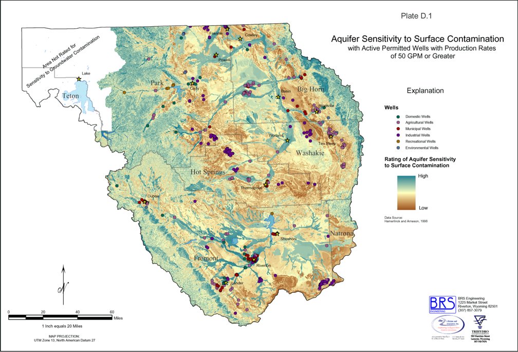
The University of Wyoming's Spatial Data and Visualization Center (SDVC) developed a system to assess the sensitivity and vulnerability of ground water to surface water contamination in Wyoming (Hamerlinck and Arneson, 1998a). Potential sources of contamination in the planning area include railroad and highway transportation routes, oil and gas pipelines that traverse the basin, oil and gas wells and well fields, hazardous waste spills, agricultural chemicals applied to farmlands, mining related chemicals and wastes, and underground injection wells. Development of the system was made possible through USEPA Section 319 Program funding. Additional financial support was provided by the Wyoming Non-Point Source Task Force, USEPA Region VIII, and the Wyoming Department of Environmental Quality, Water Quality Division. The Wyoming Department of Agriculture also provided support and guidance in the initial planning phase to develop the assessment system (Hamerlinck and Arneson, 1998a).
With the exception of the Yellowstone National Park area, the SDVC developed aquifer sensitivity maps to define the potential for surface contamination to impact ground water in the uppermost aquifer throughout Wyoming. Plate D.1 of Appendix D is a map of aquifer sensitivity to contamination within the planning area. Lands rated as being most sensitive to contamination generally are located on alluvial deposits adjacent to rivers, streams, and lakes; on slope wash, colluvium, residium, and eolian deposits; and on fractured bedrock areas.
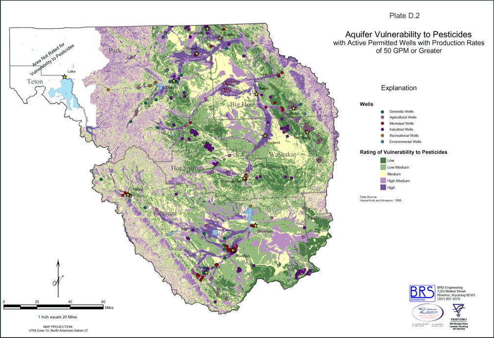
Plate D.2 of Appendix D is a map of aquifer vulnerability to pesticide contamination for the uppermost or shallowest aquifers in the area. Ground water is vulnerable in areas with high water tables, sandy soils, and areas of presumed pesticide application. Areas with the highest vulnerability are also generally located in the floodplains of major streams or are associated with slope wash, colluvium, residium, and eolian deposits.
Ground Water Development
Within the limits of the planning area, ground water is the primary source of water for many uses. While the Madison and Wind River Aquifers represent the most utilized sources of municipal supply, all 13 aquifers are important water sources for different reasons within the planning area.
Existing Development
The 12,381 active ground water permits inventoried by the WSEO as of December 31, 2001, demonstrate the overall significance of ground water resources in the planning area. From these wells, two GIS database layers were prepared to show the locations of non-domestic wells that have water rights of greater than 50 gpm. Two maps showing the locations of all permitted domestic wells were also prepared. The following bulleted list summarizes the number of wells for each usage category that were used in the preparation of the GIS data layers:
The locations of these wells are presented with respect to surficial and bedrock geology, and usage type on Plates B.1 through B.4 in Appendix B. Review of the plates provides a general understanding of the overall significance of individual aquifers based on the type of use, well depth, geologic formation outcrop areas, and geographic location.
Within the planning area, the WSEO has permitted approximately 222.6 million gallons per day (MGD) or 682.9 acre-feet of ground water for various uses. While this amount does not indicate average daily usage, it does reveal the magnitude of existing ground water development in the area. The following paragraphs further discuss existing ground water development according to the type of use.
Agricultural wells in the basin are used to deliver approximately 88.5 MGD (271.5 acre-feet) or 39.7% of the total. Most of these wells are used to irrigate croplands or hayfields along either the margins of the basin or along alluvial channels, as shown on Plates B.1 and B.2.
The second largest use of ground water in the basin, industry uses approximately 63.3 MGD (194.2 acre-feet) or 28.4% of the total. Petroleum and mineral development companies are the major developers of ground water in this area. In fact, the Wyoming Oil and Gas Conservation Commission (2000) reported approximately 108 MGD (331.3 acre-feet) of ground water were produced from 4,937 wells in Big Horn, Fremont, Hot Springs, Park, and Washakie Counties in 2000. It is uncertain how much of this quantity was actually consumed, however, and it is presumed that most of this water was used to enhance oil or gas recovery.
Based on information provided to the WWDC, municipalities in the basin use 3.9 MGD (11.9 acre-feet) of ground water on average and a maximum of 8.8 MGD (26.9 acre-feet). This ground water is consumed by 36 municipal and non-municipal community public water systems that are located in the basin. By contrast, the WSEO has already issued permits for 54.2 MGD (166.3 acre-feet) of ground water development, which suggests either that the WSEO believes there are sufficient quantities of ground water still available for development, or that more water is being used than is being reported.
Domestic ground water use in the basin was estimated on the basis of the rural population, which predominately uses ground water for domestic supply. While the total population of the planning area as of 2000 has been estimated to be 86,222 people, the population of municipalities and those served by public water systems has been estimated to be approximately 60,220. To quantify the amount of ground water used for domestic purposes, the population served by municipal systems was subtracted from the total population for the area, or 26,002 people. Assuming the rural domestic population uses between 150 and 300 gallons per capita per day, approximately 3.9 to 7.8 MGD (11.9 to 23.9 acre-feet) of ground water is used to supply the rural population of the planning area.
Ground water is also used for recreational and environmental purposes in the basin. This ground water is used to supply fish hatcheries, campgrounds, and private recreational facilities. Approximately 4.78 MGD (14.7 acre-feet) of the total are used for recreational purposes, while 4.15 MGD (12.7 acre-feet) are used for environmental purposes. Actual consumptive use is likely much less than these figures.
Impacts of Existing Development
At the request of the WWDC, LA has attempted to semi-quantitatively assess the impacts of well interference on ground water levels and wellhead pressures in the vicinity of Ten Sleep, and Riverton. The Wind River Aquifer near Riverton has been extensively developed primarily for municipal and domestic use. In the vicinity of Ten Sleep and Hyattville, the Tensleep Aquifer, Madison Aquifer, and the Flathead Sandstone have been developed not only for agricultural use, but are also used for municipal and industrial purposes. These particular areas were investigated to assess whether or not enforced ground water management may be warranted at this time.
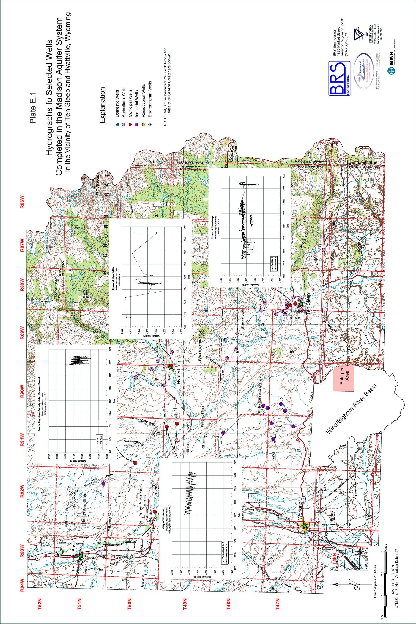
Based on WSEO records, approximately 48 wells with water rights in excess of 50 gpm have been drilled within the area around Ten Sleep and Hyattville since 1945, as shown on Plate E.1. Most of these wells were completed in either the Madison Aquifer or the Flathead Sandstone and are flowing artesian. Used for municipal purposes, the City of Worland wells, Husky No. 1 and Worland No. 3, have the largest ground water appropriation of any wells in the area at 5,000 and 6,660 gpm respectively. In combination with the other seven municipal and quasi-municipal wells in the area, approximately 13,800 gpm of water rights have been allocated for municipal use in the area shown on Plate E.1. The second largest use of ground water in the area is irrigation. This area contains eleven wells that are each permitted to produce more than 400 gpm, and yield a combined total of approximately 13,300 gpm.
The overall impact of existing ground water development from the Paleozoic Aquifers in the vicinity of Ten Sleep and Hyattville varies with time and by geographic location. In arriving at this conclusion, LA obtained wellhead pressure data from Worland, Hyattville, Ten Sleep, the South Bighorn Regional Joint Powers Board, and the WSEO. LA also held a June 18, 2002, meeting with local agricultural users in an unsuccessful attempt to obtain similar information from local landowners. Cooley (1986) and Susong and others (1993) reported that periodic data from various wells in the area were collected by the USGS in 1953, 1962, 1970, 19751978, and 1989. Cooley (1986) reported a decrease in the wellhead pressure of Ten Sleep No. 1 in Section 16 of T47N, R88W, between 1972 and 1977 that corresponded to decreased combined flow from a well and spring at the Wigwam Fish Rearing Station east of Ten Sleep. However, recent data from this well and Ten Sleep No. 2 in Section 17 of T47N, R88W, suggest the static artesian pressure of the Madison Aquifer at this location has not declined. In recent years, Madison Aquifer artesian pressures appear to be declining in the vicinity of Worland.s wells in T49N, R91W near Hyattville, as shown on Plate E.1. Wellhead pressures for wells completed in the Flathead Sandstone also continue to decline due to continuous production via irrigation or interaquifer leakage (Susong and others, 1993).
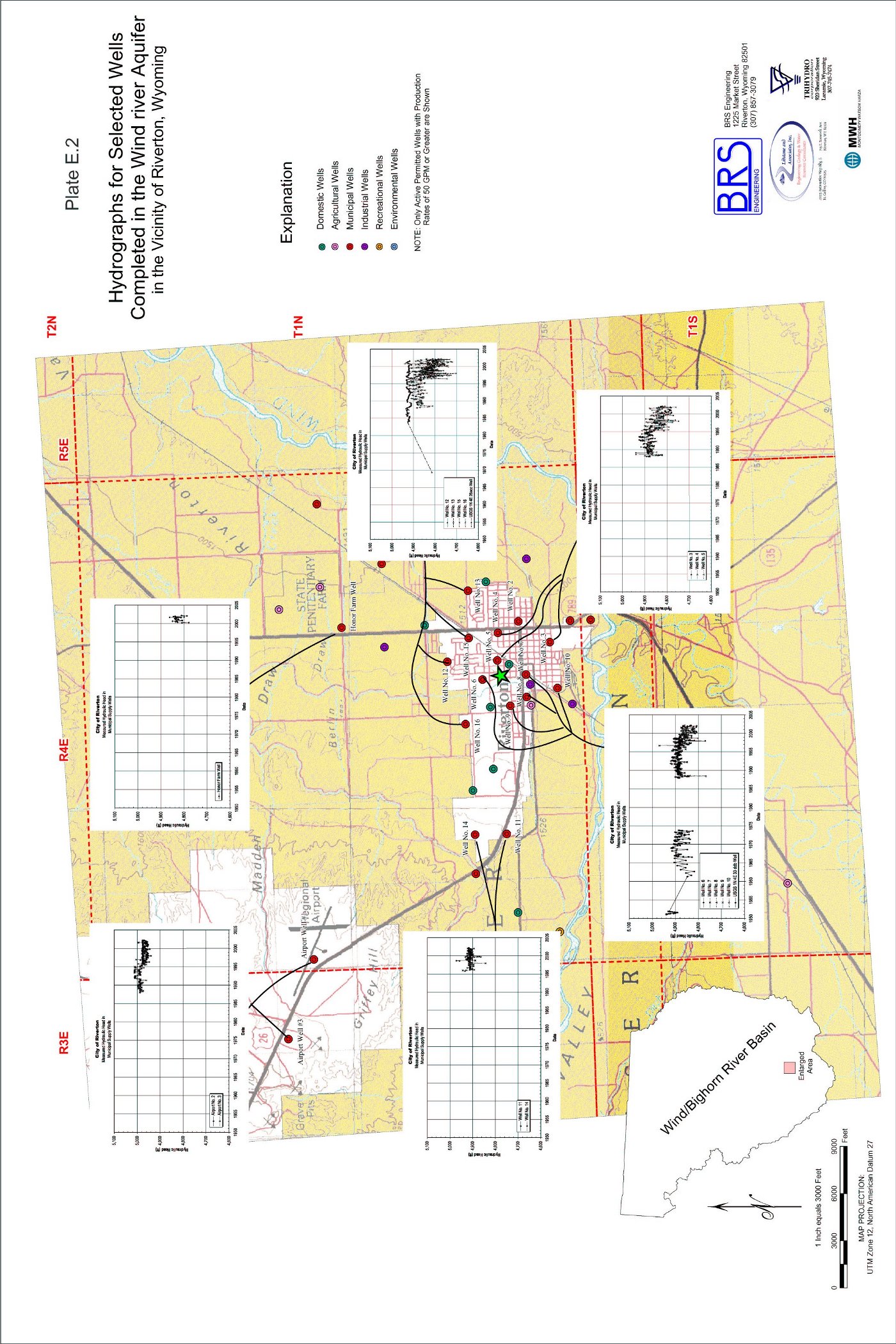
In contrast to the Ten Sleep and Hyattville vicinity, ground water from the Wind River Aquifer in the vicinity of Riverton is almost exclusively used for municipal or quasi-municipal purposes. Of the roughly 1,010 ground water permits issued by the WSEO near Riverton, approximately 98% are used for municipal or domestic use (Gores and Associates, 1998). Only 44 of these permits are for ground water production of 50 gpm or more, and 23 of the 25 wells that are permitted for 100 gpm or more are completed at depths of 300 feet or greater. According to the WSEO, all 13 of Riverton.s municipal supply wells are completed at depths of 300 feet or greater. Gores and Associates (1998) reported these wells are permitted to yield a total of 4,015 gpm. The average production of these wells between 1987 and 1996 was 710 gpm.
Water level records maintained by the City of Riverton and the USGS indicate ground water levels in the Wind River Aquifer have been lowered as a result of municipal ground water production since 1924, as shown on Plate E.2. While monthly production records for Riverton.s well field are only available since July 1957, these records reveal that ground water production steadily increased from 632 to 1,357 gpm per year between 1958 and 1980. Annual well production dropped to approximately 696 gpm following the City.s installation of a surface water treatment plant in June 1981 (Gores and Associates, 1998). Although demands on the Wind River Aquifer between May and September have been reduced through the treatment and use of surface water from the Wind River, water levels in the Riverton area remain well below those of the 1940s. In the vicinity of the inactive municipal wells in southwestern Riverton, water levels are approximately 60 feet below 1940s levels based on static water levels reported on well completion reports, and water levels in the vicinity of Riverton.s current production wells are well over 90 feet lower (Gores and Associates, 1998). Furthermore, Riverton.s long reliance upon the storage capabilities of the aquifer has resulted in an area-wide lowering of the water level by approximately 30 feet.
Based on recorded declines in water levels and wellhead pressures in these areas near Hyattville and Riverton, the WSEO may want to further investigate these areas and communicate with local residents regarding the necessity of establishing some degree of ground water management at these locations.
Future Development
Geologic conditions, drilling depths, hydrogeologic characteristics, and the ground water quality of the numerous aquifers vary throughout the planning area. Depending upon the proposed type of use and required water quantities, virtually all of the aquifers probably have some potential for development. Site specific investigations and experience will be required to assess specific possibilities to develop ground water from wells with sufficient capacity for a specific use.
While numerous hydrogeological investigations have been conducted in the planning area, there have been few, if any, regional assessments of the annual recharge, storage, and sustained yield capability of the major aquifers. General conclusions regarding the ground water development potential of several of the major aquifers are summarized below:
Table 2 summarizes the development potential of each aquifer within the planning area along with its general lithologic and hydrologic character, and its general ground water quality.
FIGURES
| Figure 1 | Location and Geologic Fault Map of the Wind/Bighorn Basin Planning Area |
| Figure 2 | Ages, Lithologies, and Thicknesses of Rocks Exposed in the Wind/Bighorn Basin |
| Figure 3 | Surficial Geologic Map of the Wind/Bighorn Basin |
| Figure 4 | Bedrock Geologic Map of the Wind/Bighorn Basin |
| Figure 5 | Geologic Cross Sections of the Wind River Basin, Wyoming |
| Figure 6 | Geologic Cross Sections of the Bighorn Basin, Wyoming |
| Figure 7 | Hydrologic Roles and Ages of Rocks in the Wind/Bighorn Basin |
| Figure 8 | Total Dissolved Solids Concentrations in Water Samples by Aquifer in Washakie County, Wyoming |
| Figure 9 | Total Dissolved Solids Concentrations in Water Samples by Aquifer in Big Horn County, Wyoming |
| Figure 10 | Total Dissolved Solids Concentrations in Water Samples by Aquifer in Fremont County, Wyoming |
| Figure 11 | Suitability of Water from Selected Aquifers for use in Irrigation based on Analyses of Water Samples from Wells, Big Horn County, Wyoming |
| Figure 12 | Suitability of Water from Selected Aquifers for use in Irrigation based on Analyses of Water Samples from Wells, Washakie County, Wyoming |
| Table 1: | Lithologic And Hydrologic Characteristics Of Rock Units In The Bighorn and Wind River Basins, Wyoming |
| Table 2: | Groundwater Availability And Development Potential Of The Major Aquifers In The Bighorn and Wind River Basins, Wyoming |
APPENDICES
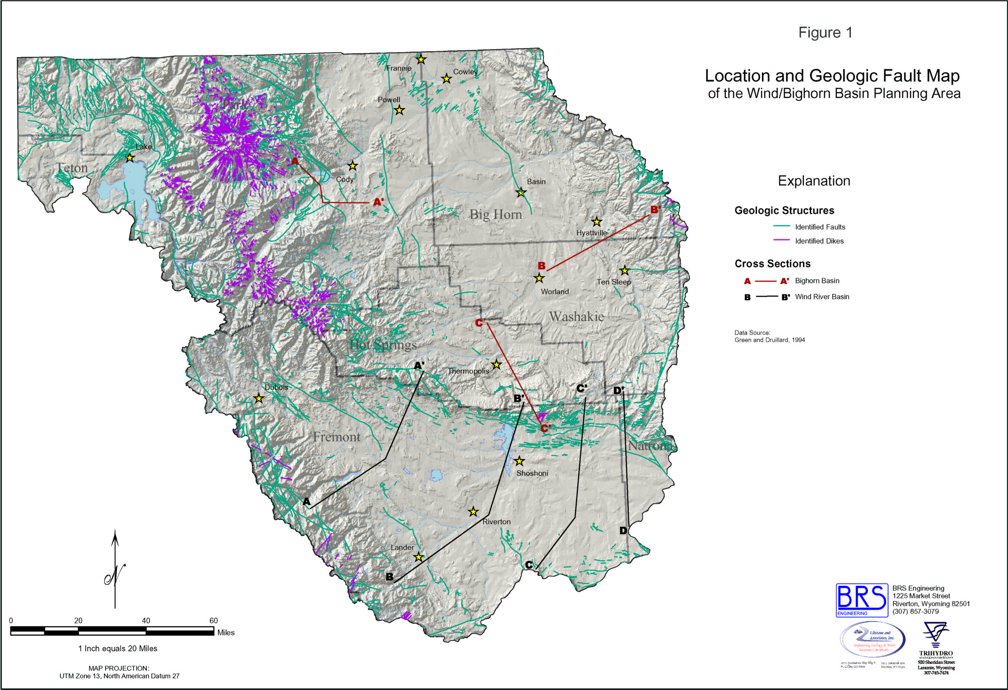
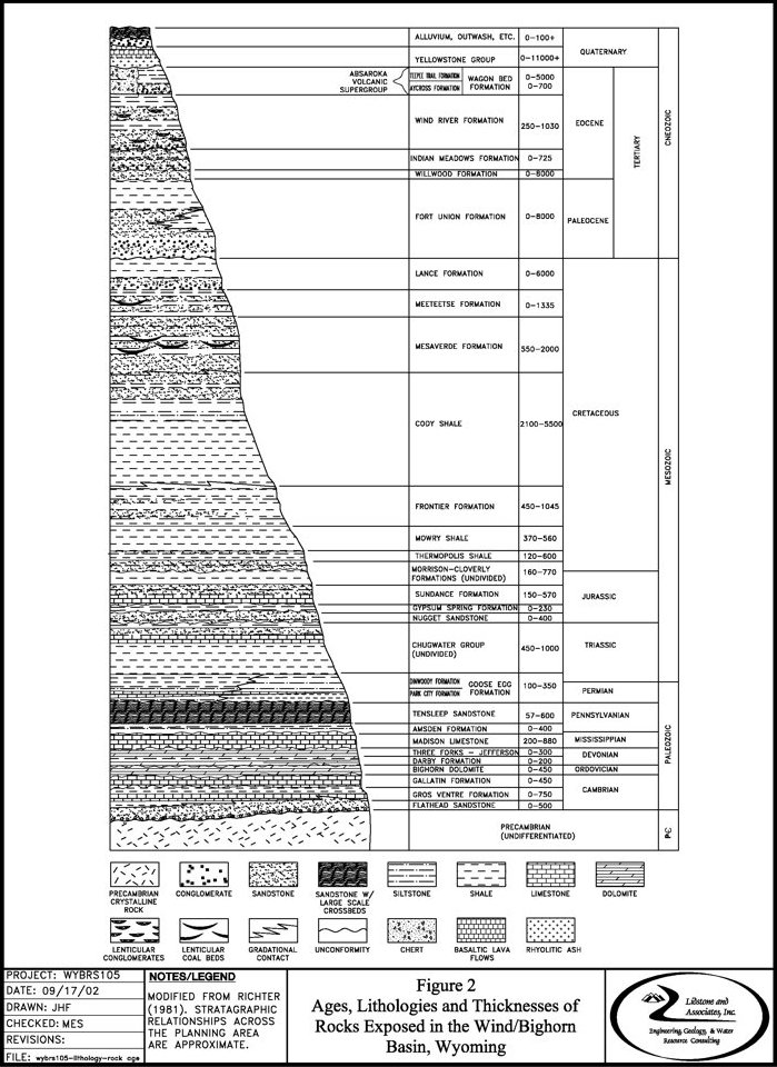
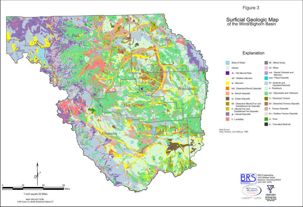
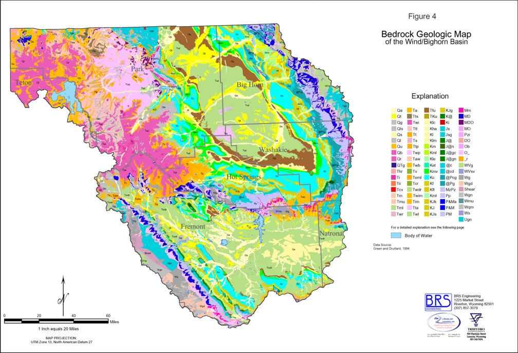
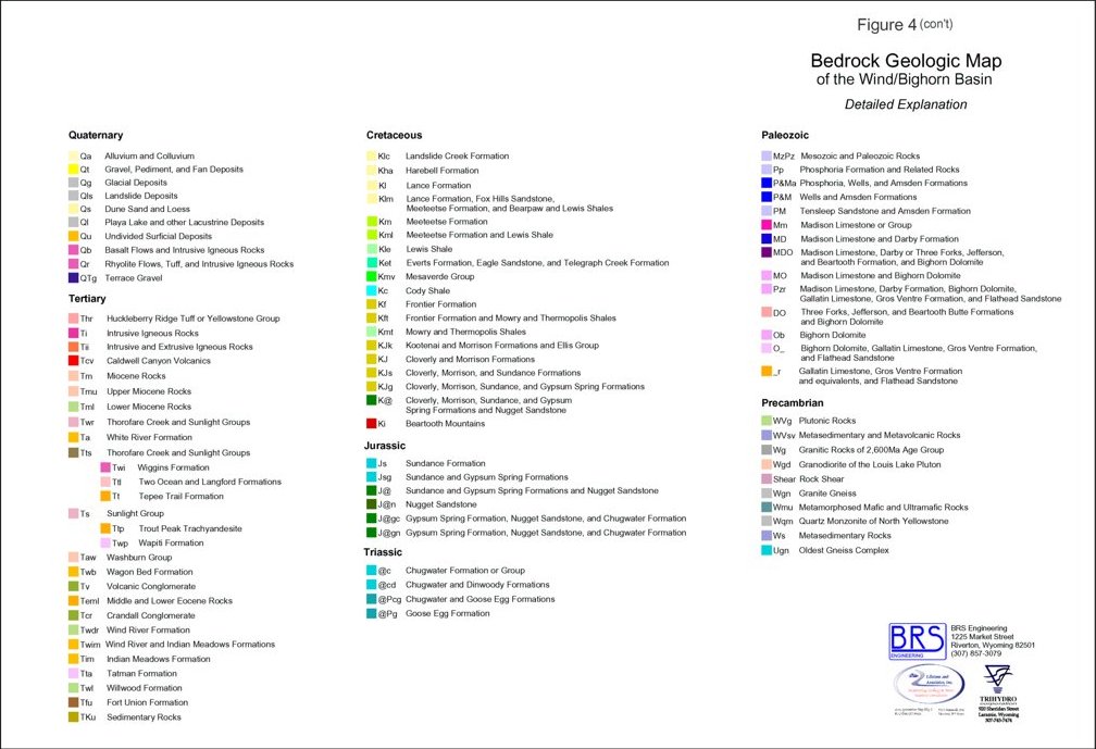
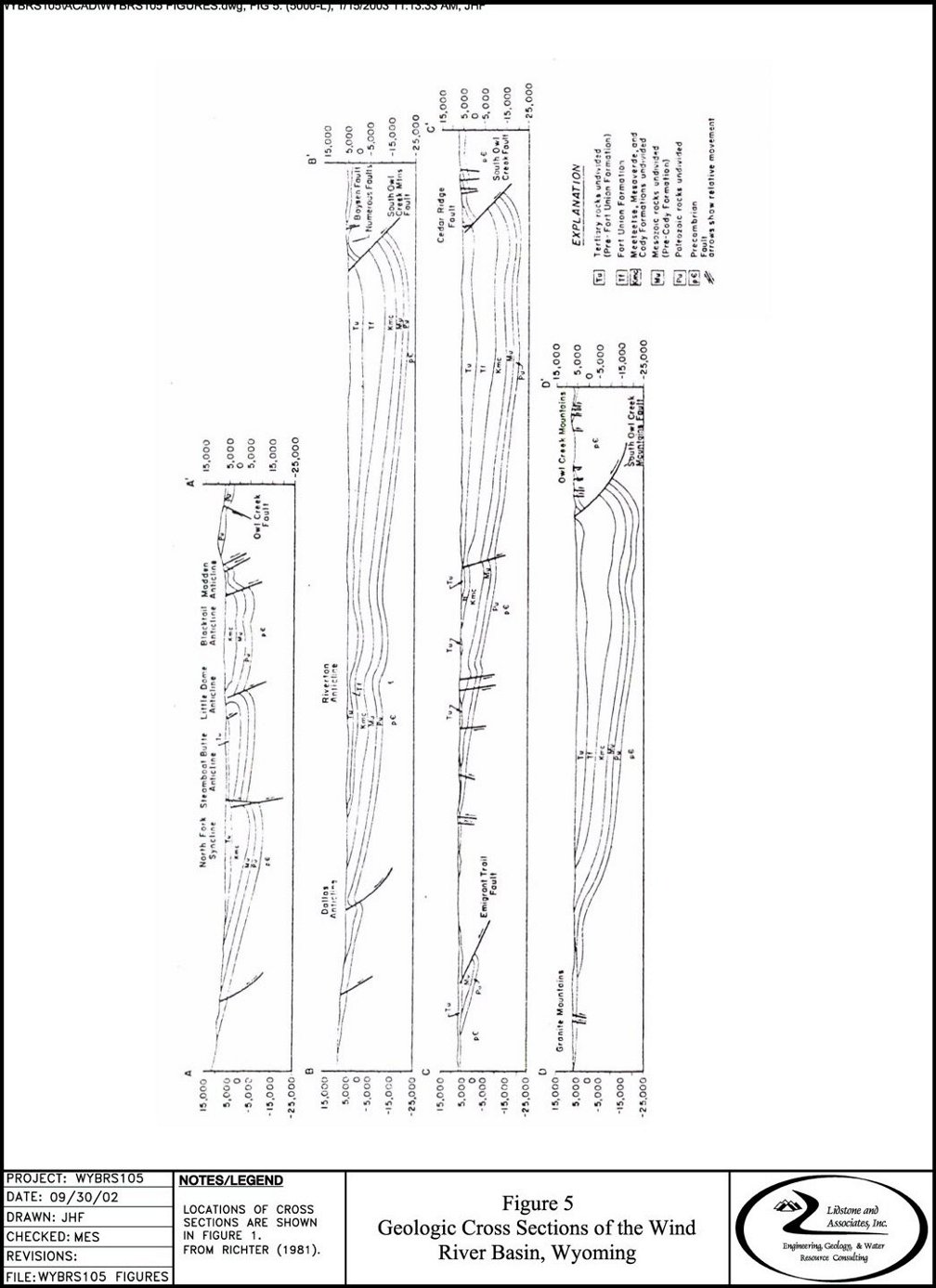
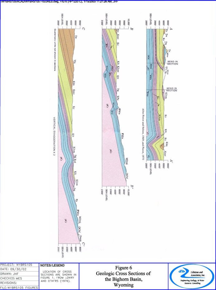
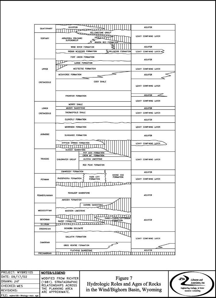
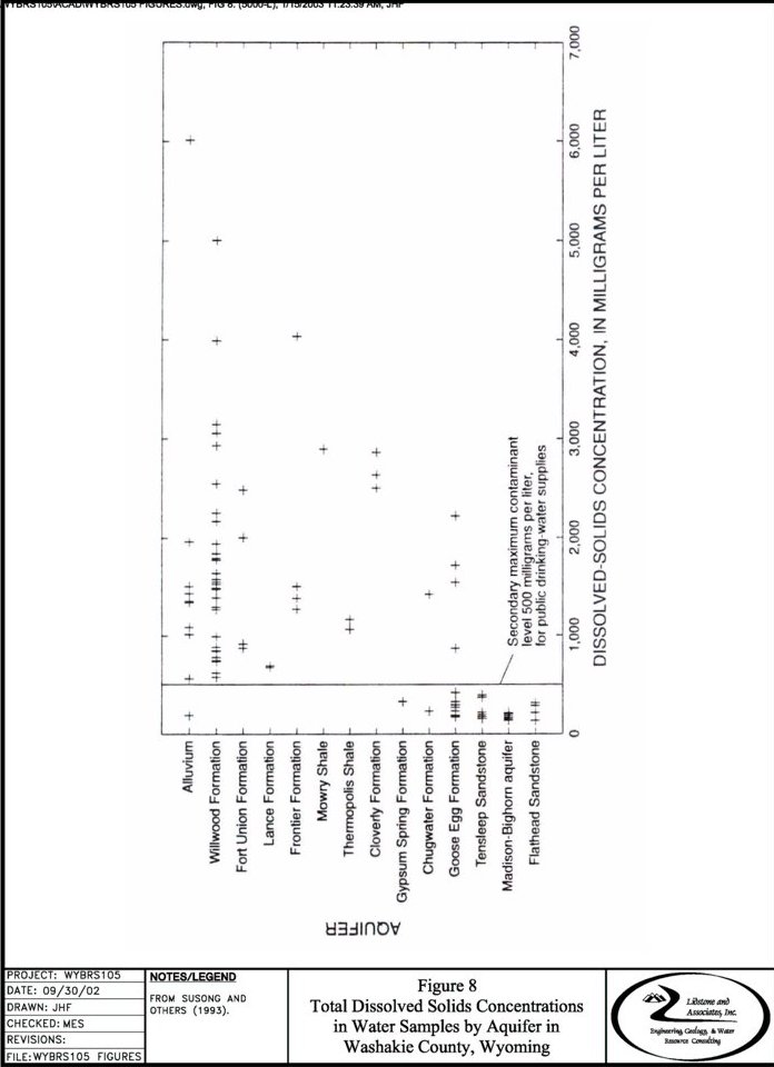
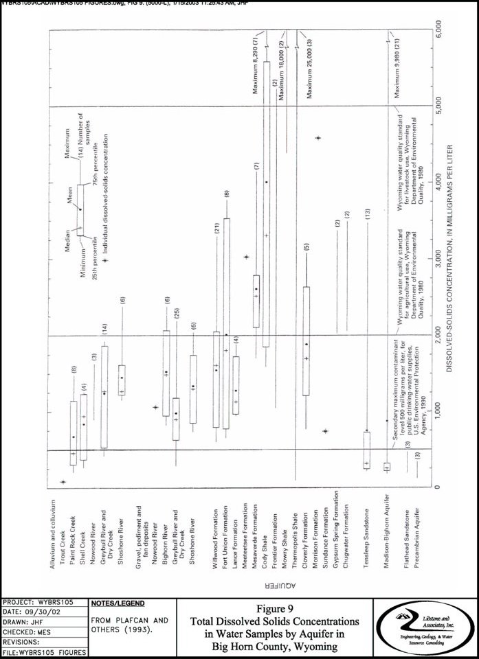
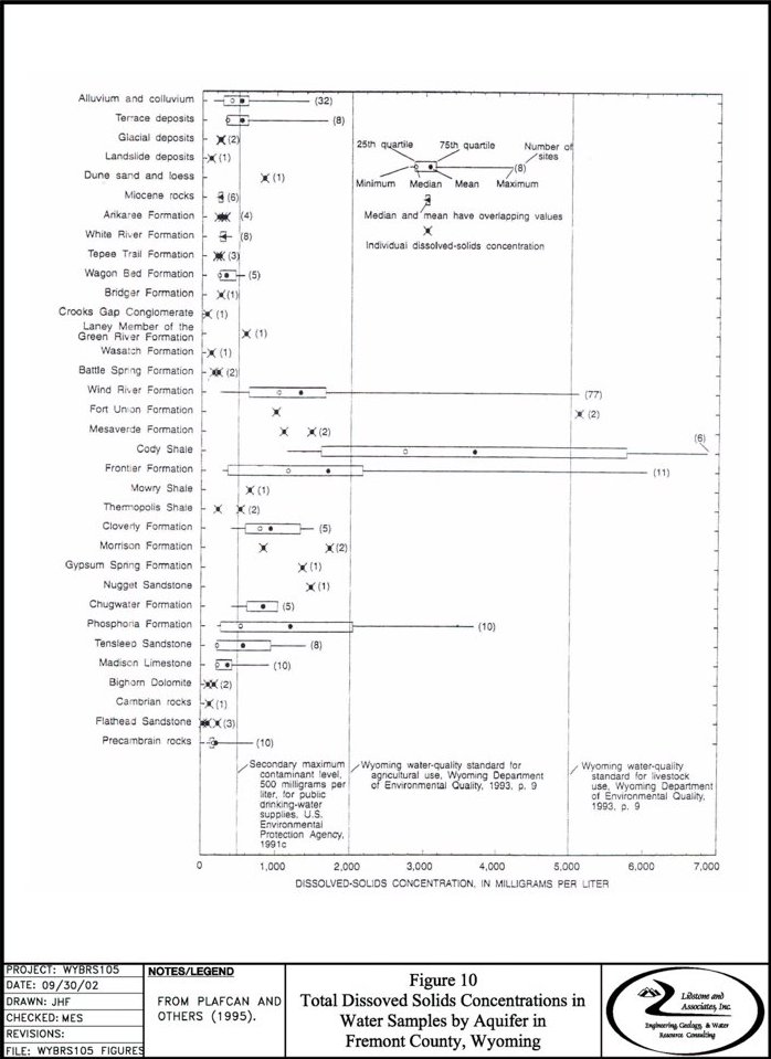
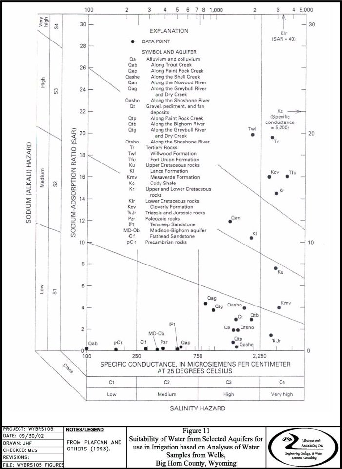
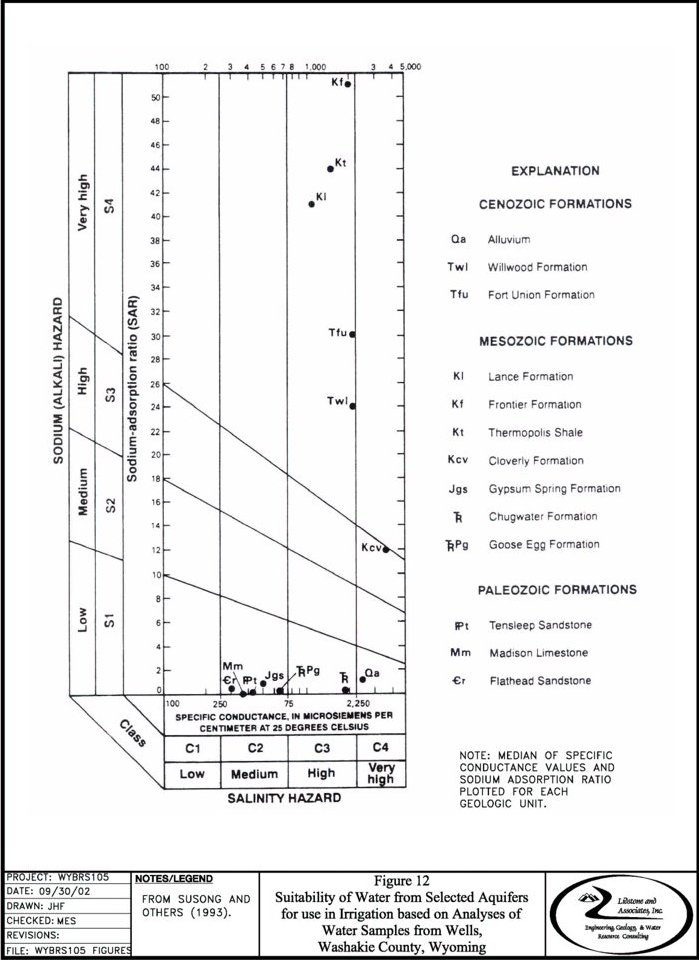
TABLE 1
Lithologic and Hydrologic Characteristics
Of Rock Units in The Bighorn & Wind River Basins, Wyoming1
| Era | Period | Geologic Unit | Thickness (ft) | Lithologic Character | Hydrologic Character |
| Cenozoic | Quaternary | Flood-plain alluvium and glacial outwash terrace gravel deposits, glacial moraine, lacustrine deposits. | 0-100+ | Unconsolidated silt, sand, gravel, and boulders. Present along and adjoining major stream channels & tributaries. Terraces 50-300' above present stream levels. | Major Aquifer. Yields > 200 gpm possible, especially where induced recharge from diverted irrigation water occurs. Yields range from < 50 to 1,600 gpm throughout Bighorn Basin,and ranges from 1 to >1,000 gpm in Wind River Basin. Terraces are topographically high and often drained by seeps and springs along an escarpment. Specific Capacity: 0.1-300 gpm/ft Permeability: 1,000-4,400 gpd/ft2 Transmissivity: 200-80,000 gpd/ft |
| -Unconformity- | |||||
| Quaternary | Yellowstone Group | 0-11.000+ | Rhyolitic ash, welded tuff, basalitic lava flows, breccia and glass. Exposed only in Yellowstone National Park area. | May yield a few tens of gallons per minute to individual wells from porous, brecciated, or fractured zones. Spring yields range up to 200 gpm. Also yields water to various fumaroles and hot springs in Yellowstone National Park. | |
| -Unconformity- | |||||
| Tertiary | Wagon Bed Formation | 0-700 | Tuffaceous and bentonitic sandstone, siltstone, and mudstone. Poorly sorted coarse pebble conglomerate and arkose at top and base of unit. Chert lenses and silicified mudstone lenses in upper 100 feet. Unit exposed only along southern margin of Wind River Basin. | Yields water locally to springs and shallow wells. Yields less than 10 gpm. Saturated zones include sandstone and conglomerate lenses. Water qualities are poor with total siddolved solids between 1,500 to 2,500 mg/1. Not considered an aquifer. | |
| Tertiary | Absaroka Volcanic Supergroup | 0-5,000 | Andesitic, basaltic, and dacitic volcaniclastic rocks exposed in Yellowstone National Park and Absaroka Mountains. | Would not likely yield more than a few gallons per minute to individual wells. | |
| Tertiary | Tepee Trail Formation | 0-2,000 | Tuff and tuffaceous siltstone, finegrained sandstone, and deutirified volcanics. Exposed only in northwestern part of Wind River Basin. Member of Absaroka Volcanic Supergroup. | Yields 8 to 37gpm of water to springs and shallow wells doing outcrop. Confining layer. | |
| Tertiary | Aycross Formation | 0-1,000 | Series of shale, clay, congolmerate, volcanics, and sandstone. Exposed only in northwestern part of Wind River basin. Member of Absaroka Volcanic Supergroup. | Confining layer. | |
| Tertiary | Wind River Formation | 250-1,030 | Variegated siltstone, shale, claystone, and argillaceous sandstone with interbedded fine-grained sandstone, arkose, and arkosic sandstone. Tuffaceous and bentonitic mudstone lenses in upper 500 feet. Unit exposed throughout Wind River Basin. | Major Aquifer. Yields water to wells and springs throughout Wind River Basin. Yields range between 0.1 to 3,000 gpm. Locally contains artesian zones with sufficient head to produce 200 gmp. Principle source of domestic and stock water on and near Wind River Indian Reservation. Principal source of industrial water in southern part of Wind River Basin. Specific Capacity: 0.04-23 gpm/ft | |
| Tertiary | Indian Meadows Formation | 0-725 | Series of variegated claystone, argillaceaous sandstone, massive limestone, and poorly sorted conglomerate. Unit exposed in Wind River Basin. | Confining layer. | |
| Tertiary | Willwood Formation | 0-8,000 | Highly variable, "red-banded" sub arkose sandstone interbedded with siltstone, mudstone, and locally conglomerate discontinuous sandstone lenses. Unit exposed in the central Bighorn Basin. | Aquifer. Yields from discontinous sandstones generally between 5-30 gpm throughout the central Bighorn Basin; yields as large as 120 gpm have been reported. Specific Capacity: 0.01-8.50 gpm/ft | |
| -Unconformity- | |||||
| Tertiary | Fort Union Formation (Polecat Bench Fm.) | 0-8,000 | Basal, cliff-forming sandstone and conglomerate, overlain by interbedded claystone, sandstone, siltstone and minor coal. | Aquifer. Development not as extensive as in overlying Willwood Fm. Congolmerate and sandstone units yield water to wells. Highly productive and permeable where fractured. Water is semi-confined to confined with sufficient head to produce 10 gpm. Yields generally >20 gpm throughout Bighorn basin, but up to 30 gpm have been reported. Basal part of unit is considered a regional confining layer. Upper part of unit contains complex series of permeable and confining layers. Specific Capacity: 0.016-3.0 gpm/ft | |
| -Unconformity- | |||||
| Mesozoic | Cretaceous | Lance Formation | 0-6,000 | Massive to thin bedded sandstone poorly sorted shale pebble conglomerate, grades upward to carbonaceous shale, siltstone, with thin lenses of bentonite and coarsegrained sandstone. Thin coal lenses in uppermost part of unit | Aquifer. Wells generally completed in Fort Union and Lance. Unit is highly productive and permeable in Bighorn Basin (yields range between 1 to 100 gpm). Specific Capacities: 0.8-13.3 gpm/ft. |
| Cretaceous | Meeteetse Formation | 0-1,335 | Massive to lenticular, poorly indurated fine-grained clayey to silty sandstone interbedded with siltstone, claystone, shale, bentonight, and minor thin coal beds. | Few well completed in this unit in the Bighorn basin and a regional confining layer found in the Wind River Basin. Yields dependent upon number of saturated sandstone beds encountered during drilling. | |
| Cretaceous | Mesaverde Formation | 550-2,000 | Upper: very fine to coarse grain, massive to cross-bedded, friable sandstone. Few shale, claystone, and carbonaceous shale interbeds. Middle: interbedded carbonaceous shale, siltstone, and sandstone. Some lenticular coal beds up to 13 feet thick. Basal: very fine to medium grain, irregularly bedded to massive sandstone. | Aquifer. Mesaverde water wells primarily located in southwest and southeast parts of Bighorn basin yielding <20 gpm (5-10 gpm on the average) although yields up to 300 gpm have been reported in the planning area. Artesian flows reported from several petroleum test wells in Wind River Basin. Specific Capacity: 0.2-3.8 gpm/ft. | |
| Cretaceous | Cody Shale | 2,100-5,500 | Lower half dominantly dark gray marine shale, glauconitic sandstone, and thin bentonite beds whereas upper half is mainly interbedded gray, sandy shale and sandstone. | In fractured areas and where encountering confined sandstone beds, yields up to 20 gpm may be obtained. Generally a regional confining layer. Specific Capacity: 0.03-1.4 gpm/ft | |
| -Unconformity- | |||||
| Cretaceous | Frontier Formation | 450-1,045 | Alternating seequence of sandstone and shale. Sandstone: fine to medium grain, thin bedded to massive, locally glauconitic. Shale: fissile, silty and sandy, locally carbonaceaus. | Aquifer. Upper 2/3 of unit is regional aquifer; lower 1/3 of unit is confining layer. Water is under confined conditions with sufficient head to produce flows of 12 to 25 gpm at selected petroleum test wells. Yields 0.5 to 150 gpm to shallwo stock and domestic wells. Specific Capacity: 0.1-65 gpm/ft Porosity: 10-26% Permeability: 0-1.4 gpd/ft2 Transmissivity: 0-45,000 gpd/ft | |
| -Unconformity- | |||||
| Cretaceous | Mowry Shale | 370-560 | Interbedded siliceaus shale and bentonite. Some Claystone. | Yields water locally in fracture zones. Considered regional confining layer in Wind River basin. | |
| Cretaceous | Muddy Sandstone | 20-75 | Sanstone, poorly to well sorted, fine to medium grain, salt and pepper sandstone. Grades locally to siltstone and sandy shale. | Aquifer. Oil and water-bearing unit. Water is under confined conditions with sufficient head to produce flows of 1 to 20 gpm at selected petroleum test wells. | |
| Cretaceous | Thermopolis Shale | 120-600 | Soft shale with bentonite beds with sandy and silty zones. Muddy Sandstone member mentioned above, approximately 40 feet thick, about 200 feet above base. | Regional confining layer. | |
| Cretaceous | Cloverly Formation | 85-470 | Composed of three units, upper sandstone, middle shale, and a lower lenticular conglomeratic sandstone. | Aquifer. Permeable and productive upper and basal sandstones. Water is under artesian conditions with sufficient head to produce flows of 1 to 25 gpm at selected petroleum test wells. Yields 5-20 gpm to various wells. Specific Capacity: 0.02-4 gpm/ft Porosity: 7-15% Permeability: up to 2.2 gpd/ft2 Transmissivity: 0-50 gpd/ft. | |
| -Unconformity- | |||||
| Jurassic | Morrison Formation | 75-300 | Variegated sandy shale and mudstone with lenses of fine-grained sandstone, conglomerate and limestone. | Sandstone beds produce small yields where they are extensive. Water is under confined conditions. Yields <5 gpm. Considered regional confining layer. Parosity: 15%± | |
| Jurassic | Sundance Formation | 150-570 | Upper: fine to coarse grain glauconitic sandstone with few think shale and fassiliferous limestone interbeds. Basal: siltstone and sandstone; grade downward to oolitic limestone, dolomite, and chert pebble conglomerate. | Aquifer. Large intergranular permeability in sandstone and chert lenses. Yields water to shallow stock and domestic well along outcrops (1 to 25 gpm). Water is under confined conditions. Selected petroleum test wells yield flows of 25 to 50 gpm. | |
| -Unconformity- | |||||
| Jurassic | Gypsum Spring Formation | 0-230 | Upper: alternating sequence of siltstone, shale, limestone, dolomite, and massive gypsum beds. Basal; sandy siltstone and silty shale. | Solution zones in gypsum beds yield small amounts of water. Yields as large as 28 gpm reported. Generally considered a regional confining layer. | |
| -Unconformity- | |||||
| Jurassic | Nugget Sandstone | 0-400 | Upper: sandstone, fine to medium grain, calcite and silica cement, and large scale cross beds. Basal: calcareous siltstone and mudstone, think limestone, and thin to massive, very-fine grain sandstone. | Aquifer. Good intergranular permeability. Saturated conditions reported for numerous petroleum test wells throughout Wind River Basin only. Water is under confined conditions. Yields on Wind River Indian Reservation range from 10-90 gpm. Specific Capacity: 3.3-8.2 gpm/ft | |
| Triassic | Chugwater Group | 450-1,000 | Interbedded red shale siltstone and fine-grained sandstone with one limestone bed in the southern part of the Bighorn basin. Contains some gypsum. | Sandstones and gypsum beds produce small amounts of artesian water locally. Good intergranular permeabilityin upper and basal sandstone members yield small quantities (<20 gpm) of water to shallow domestic and stock wells along outcrops. Yields up to 75 gpm from several springs on Wind River Indian Reservation. Water qualities can be less than 1,000 mg/l total dissolved solids. Specific Capacity: 1.0-17 gpm/ft Porosity: 15-22% Permeability: 034-2.2 gpd/ft2 Transmissivity: 5-40 gpd/ft. | |
| Triassic | Dinwoody Formation | 0-250 | Interbedded sandy dolomitic siltstone, calcareous sandstone, and thin dolomite and limestone. | Confining layer. | |
| -Unconformity- | |||||
| Paleozoic | Permian | Phosporial Formation (Park City Formation) (Goose Egg Formation) | 100-350 | Interbedded dense limestone, dolomite, nonresistant siltstone and fine grain sandstone. Grades eastward to dominantly limestone, dolomite, and calcareous shale. In eastern Bighorn Basin, contains red shale and slitstone interbedded with limestone and gypsum beds. | Aquifer. Complex series of permeable sandstones and impermeable limestone, dolomite, and siltstone. Highly productive where fractured. Well and spring yields range up to 1,000 gpm. Porosity: 2-24% Permeability: <0.1-1.4 gpd/ft2 Transmissivity: <0,5-40 gpd/ft. |
| -Unconformity- | |||||
| Pennsylvanian | Tensleep Sandstone | 57-600 | Tan to white, massive, crossbedded sandstone. Lower part more dolomitic with interbedded carbonate beds. Primary intergranular porosity and secondary fracture porosity present. | Major Aquifer. Artesian wells often flow at the surface with yields commonly 50 to 250 gpm. Good intergranual permeability. excellent permeabilities where fractured. Generally saturated throughout the planning area. Water is under confined conditions with sufficient head to produce flows of 1 to several hundred gpm from selected wells. Tremendous oil reservoir within basin interiors. Specific Capacities: 0.2-5 gpm/ft Porosity: 3-27% Permeability: 0.02-15 gpd/ft2 Transmissivity: <1-3,000 gpd/ft | |
| Pennsylvanian | Amsden Formation | 0-400 | Upper: complex sequence of nonresistant shale, dense dolomite, thin cherty limestone and thin, resistant, fine grain sandstone. Red shale above basal unit. Basal: Darwin Sandstone Member, sandstone, fine to medium grain, cross-bedded to massive, friable, and porous. | Part of Tensleep or Madison Aquifer due to middle confining layer, the Horseshoe Shale. Darwin sandstone: permeable along joints and partings between bedding surfaces. Excellent permeablities where fractured. Water is confined. Well yields range between 1 to several hundred gpm. Porosity: 10%± | |
| -Unconformity- | |||||
| Mississippian | Madison Limestone | 200-880 | Massive crystalline limestone and dolomite with siltstone and shale zones, cherty in places. Breccia filled paleokarst in upper part and a second breccia zone in middle. Secondary porosity due to solution along joints and fractures. | Major Aquifer. Poor permeabilities except where fractured. Some saturated caverns. Water-bearing throughout the planning area. Water is confined. Well yields in the planning area range from 1 to 14,000 gpm. Specific Capacities: 0.1-673 gpm/ft Porosity: 10-21% Permeability: 0.4-16 gpd/ft2 Transmissivity: 6.7-14,200 gpd/ft; 30,000 gpd/ft or more where highly fractured | |
| -Unconformity- | |||||
| Devonian | Three Forks-Jefferson Formation (undivided) | 0-300 | Siltstone, dolomite and limestone with green and black shales and silty dolomite in the western part of the Bighorn basin. | Part of Madison Aquifer. Generally considered a confining layer. | |
| Devonian | Darby Formation | 0-200 | Dolomite, siltstone, and shale, resistant, dense dolomite in Wind River Basin. | Part of Madison Aquifer. Generally considered a confining layer, but permeable along joints and fractures. Numerous joint controlled springs along Wind River Mountains. | |
| -Unconformity- | |||||
| Ordovician | Bighorn Dolomite | 0-450 | Massive to thin-bedded dolomite and dolomite limestone. Finegrained massive sandstone at the base (Lander Sandstone Member). Porosity primarily do to fracturing and solution. Contains cavernous zones near outcrop areas. | Aquifer. Basal part of Madison Aquifer. Produces artesian water from joints, fractures, and caves. Basal sandstones are permeable. Yields water to numerous springs along Wind River Mountains and several wells in Bighorn Basin. Yields range from 1 to 1,200 gpm. Specific Capacities: 0.1-5.2 gpm/ft Porosity: 13% ± | |
| -Unconformity- | |||||
| Cambrian | Gallatin Formation | 0-450 | Limestone, dense, thinly laminated to massive, glauconitic and oolitic, shale, silty shale, and thin sandstone interbeds. | Generally considered a confining layer. Permeable along joints and fractures. Yields small quantities (<5 gpm) to springs along Wind River Mountains. Dispersed sandy interbeds may yeild small quantities of water. | |
| Cambrian | Gros Ventre Formation | 0-750 | Limestone, shale, and calcareous shale, flat-pebble conglomerate at base. Contains bentonite beds. | Confining layer. Thin sandstone beds indicate potential for small yields. One well in Hot Springs County yields 110 gpm. | |
| Cambrian | Flathead Sandstone | 0-500 | Sandstone, fine to medium grain, resistant; grades downward to conglomerate and arkose interbedded shale in upper part. | Major Aquifer. Permeable along partings between bedding planes, faults, fractures and joints. Small interstitial permeabilities. Water is semi-confined to confined. Produces water under very high artesian pressures and yields from 1 to 3,000 gpm have been reported for stock, domestic, and irrigation wells. Excellent groundwater resource potential; however, relatively undeveloped because of availability of shallower groundwater sources. Specific Capacity: 0.52-3.4 gpm/ft Transmissivity: 700-2,400 gpd/ft. | |
| -Unconformity- | |||||
| Precambrian | Undifferentiated | Complex of igneous and metamorphic rocks. Predominantly granite, granite gneiss, schist, hornblende schist, aplite and basic dikes. | Permeable along joints. Fractures and faults. Locally yields water to shallow wells along outcrops. Well yields commonly range from 5 to 10 gpm. Spring discharges range from 0.5 to 297 gpm. Specific Capacity: 0.2-2.8 gpm/ft | ||
TABLE 2
Groundwater Availability And Development Potential of The Major Aquifers
In The Bighorn & Wind River Basins, Wyoming1
| Major Aquifer | Geologic Unit | Thickness (ft) | Lithologic Character | Hydrologic Character2 | General Water Quality | Availability/Development Potential3 |
| Quaternary Aquifer | Flood-plain alluvium and glacial outwash, terrace gravel deposits, glacial moraine, lacustrine deposits. | 0-100+ | Unconsolidated silt, sand, gravel and boulders. Present along and adjoining major stream channels & tributaries. Terraces 50-300 above present stream levels. | Yields >200 gpm possible, especially where induced recharge from diverted irrigation water occurs. Yields range from <50 to 1,600 gpm throughout Bighorn Basin, and ranges from 1 to >1,000 gpm in Wind River Basin. Terraces are topographically high and often drained by seeps and springs along an escarpment. Specific Capacity: 0.1-300 gpm/ft Permeability: 1,000-4,400 gpd/ft2 Transmissivity: 200-80,000 gpd/ft. | Total dissolved solids concentrations range from 141 to 11,100 mg/l, depending upon the type of deposit ground water was obtained from. | Excellent potential for the installation of moderated to high capacity well in the various Quaternary units in the planning area. Surface water treatment requirements generally apply. |
| Wind River Aquifer | Wind River Formation | 250-1,030 | Variegated siltstone, shale, claystone, and argillaceous sandstone with interbedded fine-grained sandstone, arkose, and arkosic sandstone. Tuffaceous and bentonitic mudstone lenses in upper 500 feet. Unit exposed throughout Wind River Basin. | Yields water to wells and springs thoughout Wind River Basin. Yields range between 0.1 to 3,000 gpm. Locally contains artesian zones with sufficient head to produce 200 gpm. Principal source of domestic and stock water on and near Wind River Indian Reservation. Principal source of industrial water in southern part of Wind River Basin. Specific Capacity: 0.04-23 gpm/ft | Water qualities are highly variable with total dissolved solids ranging from 100 to 5,110 mg/l. High variability in water quality due to highly variable lithology, permeability, and recharge conditions. | Historically this aquifer has been extensively developed for municipal, domestic, industrial, and agricultural purposes in the Wind River Basin. High yield potential in areas not previously developed, particularly in the western portion of the basin. Wide variations in water quality locally will constrain its type of use |
| Willwood Aquifer | Willwood Formation | 0-8,000 | Highly variable, "red-banded" sub arkose sandstone interbedded with siltstone, mudstone, and locally conglomerate discontinous sandstone lenses. Unit exposed in the central Bighorn Basin. | Yields from discontinous sandstones generally between 5-30 gpm throughout the central Bighorn Basin; yields as large as 120 gpm have been reported. Specific Capacity: 0.01-8.50 gpm/ft | Total dissolved solids concentrations generally exceed 1,000 mg/l and are usually reported in the range from 750 to 2,000 mg/l | Low yield potential for stock and domestic purposes in the Bighorn Basin. Primarily developed for water supply along the Greybull River and Emblem Bench. Can be difficult to obtain adequate domestic supply. |
| Fort Union/Lance Aquifer | Fort Union Formation | 0-8,000 | Basal, cliff-forming sandstone and conglomerate, overlain by interbedded claystone, sandstone, siltstone and minor coal. | Conglomerate and sandstone units yield water to wells. Highly productive and permeable where fractured. Water is semi-confined to confined with sufficient head to produce 10 gpm. Yields generally <20 gpm throughout Bighorn basin, but up to 30 gpm have been reported. Basal part of unit is considered a regional confining layer. Upper part of unit contains complex series of permeable and confining layers. Specific Capacity: 0.016-3.0 gpm/ft | Water qualities are poor with total dissolved solids greater than 1,000 mg/l. Total dissolved solids concentrations increase to 20,500 mg/l in basin interiors. | Development not as extensive as in overlying Willwood Fm. Historically has been developed for stock and domestic use along rechage areas. Low yield potential in areas where the unit could be economically drilled for additional stock and domestic uses. |
| Fort Union/Lance Aquifer (continued) | Lance Formation | 0-6,000 | Massive to thin bedded sandstone, poorly sorted shale pebble conglomerate, grades upward to carbonaceous shale, siltstone, with thin lenses of bentonite and coarse-grained sandstone. Thin coal lenses in uppermost part of unit. | Wells generally completed in Fort Union and Lance. Unit is highly productive and permeable in Bighorn Basin (yields range between 1 to 100 gpm). Specific Capacity: 0.8-13.3 gpm/ft | Total dissloved solids concentrations less than 1,000 mg/l may be encountered along recharge areas, but increase basinward. | Historically has been developed for stock and domestic use along recharge areas. Low yield potential in areas where the unit could be economically drilled for additional stock and domestic uses. |
| Mesaverde Aquifer | Mesaverde Formation | 550-2,000 | Upper: very fine to coarse grain, massive to cross-bedded, friable sandstone. Few shale, claystone, and carbonaceous shale interbeds. Middle: interbedded carbonaceous shale, siltstone, and sandstone. Some lenticular coal beds up to 13 feet thick. Basal: very fine to medium grain, irregularly bedded to massive sandstone. | Mesaverde water wells primarily located in southwest and southeast parts of Bighorn basin yielding < 20 gpm (5-10 gpm on the average) although yields up to 300 gpm have been reported in the planning area. Artesian flows reported from several petroleum test well in Wind River Basin. Specific Capacity: 0.2-3.8 gpm/ft. | Water qualities poor with total dissolved solids usually greater than 1,500 mg/l | Moderate yield potential in areas where permeability has been enhanced through facturing. Suitable for use other than stock is uncertain based on limited water quality data. |
| Frontier Aquifer | Frontier Formation | 450-1,045 | Alternating sequence of sandstone and shale. Sandstone: fine to medium grain, thin bedded to massive, locally glauconitic. Shale: fillile, silty and sandy, locally carbonaceous. | Upper 2/3 of unit is regional aquifer; lower 1/3 of unit is confining layer. Water is under confined conditions with sufficient head to produce flows of 12 to 25 gpm at selected petroleum test wells. Yields 0.5 to 150 gpm to shallow stock and domestic wells. Specific Capicity: 0.1-65pm/ft Porosity: 10-26% Permeability: 0-1,4 gpd/ft2 Transmissivity: 0-45,000 gpd/ft | Water qualities highly variable and range from less than 500 to about 14,000 mg/l totaly dissolved solids. | Good source of ground water for shallow stock and domestic wells near recharge areas. |
| Muddy Aquifer | Muddy Sandstone | 20-75 | Sandstone, poorly to well sorted, fine to medium grain, salt and pepper sandstone. Grades locally to siltstone and sandy shale. | Oil and water-bearing unit. Water is under confined conditions with sufficient head to produce flows of 1 to 20 gpm of selected petroleum test wells. | Water qualities are poor with total dissolved solids generally grater than 1,500 mg/l. Total dissolved solids concentrations as low as 599 mg/l have been reported in Hot Springs County. | Low yield and generally poor water quality associated with oil production generally limit the usefulness of this aquifer. |
| Cloverly Aquifer | Cloverly Formation | 85-470 | Composed of three units, upper sandstone, middle shale and a lower lenticular conglomeratic sandstone. | Permeable and productive upper and basal sandstones. Water is under artesian conditions with sufficient head to produce flows of 1 to 25 gpm at selected petroleum test wells. Yields 5-20 gpm to various wells. Specific Capacity: 0.02-4 gpm/ft Porosity: 7-15% Permeability: up to 2.2 gpd/ft2 Transmissivity: 0-50 gpd/ft | Water qualities are generally less than 1,000 mg/l where the formation crops out and is intensely faulted or fractured. Total dissolved solids range from 450 to 30,000 mg/l. | Low to moderate yield potential from upper and basal sandstones. Local water qualities will affect potential uses. |
| Sundance/Nugget Aquifer | Sundance Formation | 150-570 | Upper: fine to coarse grain glauconitic sandstone with few thin shale and fossiliferous limestone interbeds. Basal: silstone and sandstone; grade downward to oolitic limestone, dolomite, and chert pebble conglomerate. | Large intergranular permeability in sandstone and chert lenses. Yields water to shallow stock and domestic well along outcrops (1 to 25 gpm). Water is under confined conditions. Selected petroleum test wells yield flows of 25 to 50 gpm. | Water qualities are good along outcrops with total dissolved solids less than 500 mg/l. Water qualities deteriorate basinward with total dissolved solids greater than 2,000 mg/l. | Low yield potential renders this aquifer suitable primarily for domestic and stock use in areas where suitable water qualities can be obtained. |
| Sundance/Nugget Aquifer (continued) | Nugget Sandstone | 0-400 | Upper: sandstone, fine to medium grain, calcite and silca cement, and large scale cross beds. Basal: calcareous siltstone and mudstone, thin limestone, and thin to massive, very-fine grain sandstone. | Good intergranular permeability. Saturated conditions reported for numerous petroleum test wells throughout Wind River Basin only. Water is under confined conditions. Yields on Wind River Indian Reservation range from 10-90 gpm. Specific Capacity: 3.3-8.2 gpm/ft | Insufficient data exists to meaningfully quantify water qualities | Low yield potential renders this aquifer suitable primarily for domestic and stock use in areas where suitable water qualities can be obtained. |
| Phosphoria Aquifer | Phosphoria Formation (Park City Formation) (Goose Egg Formation) | 100-350 | Interbedded dense limestone, dolomite, nonresistant siltstone and fine grain sandstone. Grades eastward to dominantly limestone, dolomite, and calcareous shale. In eastern Bighorn Basin, contains red shale and siltstone interbedded with limestone and gypsum beds. | Complex series of permeable sandstones and impermeable limestone, dolomite, and siltstone. Highly productive where fractured. Well and spring yields range up to 1,000 gpm. Porosity: 2-24% Permeabilty: <0.1-1.4 gpd/ft2 Transmissivity: <0.5-40 gpd/ft | Water qualities near recharge areas are generally good with total dissolved solids less than 1,000 mg/l. However, sodium sulfate type water with total dissolved solids concentrations ranging up to 44,339 mg/l are typical of the deeper basin areas. | Signifcant yield potential in areas where permeability has been enhanced through fracturing; however, water quality may not be suitable for all purposes, particularly municipal and domestic supply. |
| Tensleep Aquifer | Tensleep Sandstone | 57-600 | Tan to white, massive, crossbedded sandstone. Lower part more dolomitic with interbedded carbonate beds. Primary intergranular porosity and secondary fracture porosity present. | Artesian wells often flow at the surface with yields commonly 50 to 250 gpm. Good intergranular permeability, excellent permeabilities where fractured. generally saturated throughout the planning area. Water is under confined conditions with sufficient head to produce flows of 1 to several hundred gpm from selected wells. Tremendous oil reservoir within basin interiors. Specific Capacity: 0.2-5 gpm/ft Porosity: 3-27% Permeability: 0.02-15 gpd/ft2 Transmissivity: <1-3,000 gpd/ft | Water qualities along outcrops are good with calcium bicarbonate type water having total dissolved solids less than 500 mg/l. Water quality degrades basinward with total dissolved solids commonly exceeding 2,000 mg/l, and as high as 10,727 mg/l due to dissolution of anhydrite and halite from sandstone matrix. | Historically has been a major source of water used for stock and domestic purposes, but has also been developed for industrial and municipal public supply purposes. Generally does not yield sufficient water quantities for irrigation. Moderate to large yields from this aquifer may be encountered in areas of either intergranular or fracture permeability. Water quality generally suitable for most uses. |
| Tensleep Aquifer | Amsden Formation | 0-400 | Upper: complex sequence of nonresistant shale, dense dolomite, thin cherty limestone, and thin, resistant, fine grain sandstone. Red shale above basal unit. Basal: Darwin Sandstone Member, sandstone, fine to medium grain, crossbedded to massive, friable, and porous. | Part of Tensleep or Madison Aquifer. Darwin sandstone: permeable along joints and partings between bedding surfaces. Excellent permeabilities where fractured. Water is confined. Well yields range between 1 to several hundred gpm. Porosity: 10%± | Insufficient evidence to characterize, but good water quality from Darwin Sandstone where developed with Madison Limestone near Ten Sleep, Wyoming. | Low to moderate yields available from the lower Darwin Sandstone member. |
| Madison Aquifer | Madison Limestone | 200-880 | Massive crystalline limestone and dolomite with siltstone and shale zones, cherty in places. Breccia filled paleokarst in upper part and a second breccia zone in middle. Secondary porosity due to solution along joints and fractures. | Poor permeabilities except where fractured. Some saturated caverns. Water-bearing throughout the planning area. Water is confined. Well yields in the planning area range from 1 to 14,000 gpm. Specific Capacity: 0.1-673 gpm/ft Porosity: 10-21% Permeability: 0.4-16 gpd/ft2 Transmissivity: 6.7-14,200 gpd/ft; 30,000 gpd/ft or more where highly fractured. | Water qualities are good along outcrop areas. Calcium bicarbonate type water with total dissolved solids concentrations less than 500 mg/l is typically found in wells and springs near recharge area. Sodium sulfate type water with total dissolved solids concentrations as high as 4,303 mg/l is typical of basin interior water. | Highest yielding aquifer in the planning area with excellent water qualities. Significant yields from this aquifer can be expected where the permeability has been enhanced through fracturing and cavern development. Historically has been a major source of water for municipal, irrigation, argicultural, domestic, commercial, and industrial purposes in the planning area. |
| Madison Aquifer | Bighorn Dolomite | 0-450 | Massive to thin-bedded dolomite and dolomite limestone. Fine-grained massive sandstone at the base (Lander Sandstone Member). Porosity primarily do to fracturing and solution. Contains cavernous zones near outcrop areas. | Basal part of Madison Aquifer. Produces artesian water from joints, fractures, and caves. Basal sandstones are permeable. Yields water to numerous springs along Wind River Mountains and several wells in Bighorn Basin. Yields range from 1 to 1,200 gpm. Specific Capacity: 0.1-5.2 gpm/ft Porosity: 13%± | Limited and sparse data are available exclusively for this unit. Total dissolved solids concentrations in recharge areas are typically less than 250 mg/l, but concentrations as high as 3,440 mg/l have been reported in Hot Springs County. | Generally developed along with the Madison Limestone, ground water from this aquifer has been used for municiple, domestic, and irrigation purposes. Significant yield potential in areas where permeability have enhanced through fracturing and cavern development. Suitable water qualities for most purposes. |
| Flathead Aquifer | Flathead Sandstone | 0-500 | Sandstone, fine to medium grain, resistant; grades downward to congolmerate and arkose. Interbedded shale in upper part. | Permeable along partings between bedding planes, faults, fractures and joints. Small interstitial permeablities. Water is semi-confined to confined. Produces water under very high artesian pressures and yields from 1 to 3,000 gpm have been reported for stock, domestic, and irrigation wells. Specific Capacity: 0.52-3.4 gpm/ft Transmissivity: 700-2,400 gpd/ft | Excellent water qualities toward recharge areas; total dissolved solids generally less than 500 mg/l, but are known to increase to at least 4,150 mg/l in the southern Bighorn Basin. Sodium-chloride and sodium-sulfate type waters typify basin interior waters. | Significant yield potential in undeveloped areas where the intergranular permeability has been enhanced along bed parting and fractures. Historically ground water from this aquifer has been developed for irrigation, stock, and domestic purposes. Water qualities suitable for various purposes depending upon local conditions. Not easily developed due to drilling depths and caving of the overlying Gros Ventre Formation during drilling. |
Allen, E.G., 1978, Leasable mineral and waterpower land classification map of the Driggs quadrangle, Idaho, Wyoming, [showing] lands withdrawn, classified, and prospectively valuable for leasable minerals; occurrences of other selected minerals; and lands withdrawn or classified for waterpower and reservoir sites: U.S. Geological Survey, Open-File Report OF-78-722, scale 1:250000.
Anderson, B.M., 1972, Lithium in surface and ground waters of the conterminous United States: U.S. Geological Survey, Open-File Report OF-72-6, scale 1:22000000.
Bateman, A.F., Allen, E.G., Dugwyler, J.B., and Colbert, J.L., 1980, Leasable mineral and waterpower land classification map of the Ashton quadrangle, Idaho, Montana, Wyoming [showing] lands withdrawn, classified, and prospectively valuable for leasable minerals, occurrences of other selected minerals and lands withdrawn: U.S. Geological Survey, Open-File Report OF-80-484, scale 1:250000.
Berry, D.W. and Littleton, R.T., 1961, Geology and ground-water resources of the Owl Creek area, Hot Springs County, Wyoming: U.S. Geological Survey, Water-Supply Paper 1519, scale 1:63360.
Blakey, J.F., 1967, Temperature of surface waters in the conterminous United States: U.S. Geological Survey, Hydrologic Investigations Atlas HA-235, scale 1:5000000.
Borchert, W.B., 1977, Preliminary digital model of the Arikaree aquifer in the Sweetwater River basin, central Wyoming: U.S. Geological Survey, Water-Resources Investigations Report 77-107, scale 1:250000.
Borchert, W.B., 1987, Water-table contours and depth to water in the southeastern part of the Sweetwater River basin, central Wyoming, 1982: U.S. Geological Survey, Water-Resources Investigations Report 86-4205, scale 1:250000.
Bredehoeft, J.D., 1964, Variation of permeability in the Tensleep Sandstone in the Bighorn Basin, Wyoming, as interpreted from core analysis and geophysical logs, in Geological Survey Research, 1964: U.S. Geological Survey Professional Paper 501-D, p. D166D170.
Bredehoeft, J.D., and Bennett, R.R., 1972, Potentiometric surface of the Tensleep Sandstone in the Bighorn Basin, west-central Wyoming: U.S. Geological Survey Open-File Report 72461, scale 1:250000
Britton, L.J., Anderson, C.L., Goolsby, D.A., and Van Haveren, B.P., 1989, Summary of the U.S. Geological Survey and U.S. Bureau of Land Management National Coal-Hydrology Program: U.S. Geological Survey, Professional Paper 1464, scale 1:7500000.
Busby, M.W., 1966, Annual runoff in the conterminous United States: U.S. Geological Survey, Hydrologic Investigations Atlas HA-212, scale 1:7500000.
Case, J.C., Arneson, C.S., and Hallburg, L.L., 1998, Preliminary Digital Surficial Geologic Map of Wyoming: Wyoming State Geological Survey, scale 1:500000
Clark, M.L., and Sadler, W.J., 1996, Occurrence of selenium and mercury in surface water, Wind River Indian Reservation, Wyoming, 1995: U.S. Geological Survey, Water-Resources Investigations Report 96-4159, scale 1:100000.
Cooley, M.E., and Head, W.J., 1979, Hydrogeologic features of the alluvial deposits in the Nowood River drainage area, Bighorn Basin, Wyoming: U.S. Geological Survey, Open-File Report OF-79-1291, scale 1:62000.
Cooley, M.E., and Head, W.J., 1979, Hydrogeologic features of the alluvial deposits in the Greybull River Valley, Bighorn basin, Wyoming: U.S. Geological Survey, Water-Resources Investigations Report 79-6, scale 1:62000.
Cooley, M.E., and Head, W.J., 1982, Hydrogeologic features of the alluvial deposits in the Owl Creek Valley, Big Horn basin, Wyoming: U.S. Geological Survey, Water-Resources Investigations Report 82-4007, scale 1:86000.
Cooley, M.E., 1984, Artesian pressures and water quality in Paleozoic aquifers in the Ten Sleep area of the Bighorn Basin, north-central Wyoming: U.S. Geological Survey, Open-File Report OF-84-621, scale 1:250000.
Cooley, M.E., 1986, Artesian pressures and water quality in Paleozoic aquifers in the Ten Sleep area of the Bighorn Basin, north-central Wyoming: U.S. Geological Survey, Water-Supply Paper 2289, scale 1:250000.
Cox, E.R., 1976, Water resources of northwestern Wyoming: U.S. Geological Survey, Hydrologic Investigations Atlas HA-558, scale 1:250000.
Daddow, R.L., 1992, Ground-water and water-quality data through 1991 for selected wells and springs on the Wind River Indian Reservation, Wyoming: U.S. Geological Survey, Open-File Report OF-92-455, scale 1:201613.
Daddow, R.L., 1996, Water resources of the Wind River Indian Reservation, Wyoming: U.S. Geological Survey, Water-Resources Investigations Report 95-4223, scale 1:202000.
Doremus, D.M., 1986, Groundwater circulation and water quality associated with the Madison aquifer, northeastern Bighorn Basin, Wyoming: Laramie, Wyoming, University of Wyoming unpublished Master.s Thesis.
Eddy-Miller, C.A. and Norris, J.R., 2000, Pesticides in ground water -Fremont County, Wyoming, 1998-99: U.S. Geological Survey, Fact Sheet FS-35-00, scale 1:1500000.
Eddy-Miller, C.A. and Norris, J.R., 2001, Pesticides in ground water -Big Horn County, Wyoming, 1999-2000: U.S. Geological Survey, Fact Sheet FS-124-01, scale 1:872000.
Feth, J.H., Back, William, Cushing, E.M., Swenson, F.A., and Carlston, C.W., 1965, Preliminary map of the conterminous United States showing depth to and quality of shallowest ground water containing more than 1,000 parts per million dissolved solids: U.S. Geological Survey, Hydrologic Investigations Atlas HA-199, scale 1:3168000.
Fisher, C.A., 1906, Geology and water resources of the Big Horn Basin, Wyoming: U.S. Geological Survey, Professional Paper 53, scale 1:253440.
Fleischer, Michael, 1962, Fluoride content of ground water in the conterminous United States (maximum reported value for each county): U.S. Geological Survey, Miscellaneous Geologic Investigations Map I-387, scale 1:5000000.
Grasso, D.N., Jennings, M.E., and Sadler, W.J., 1995, Field screening of water quality, bottom sediment, and biota associated with irrigation drainage, Wind River Indian Reservation, Wyoming, 1992-93: U.S. Geological Survey, Open-File Report OF-95-121, scale 1:701750.
Green, G.N., and Drouillard, P.H., 1994, Bedrock Geology Map of Wyoming: U.S. Geological Survey.
Gores and Associates, P.C., 1998, Riverton regional water master plan, Level I, Final Report; Consultant.s Report prepared for the Wyoming Water Development Commission.
Graham, Dietz and Associates, 1994, Manderson water supply project, Level II, Final Report; Consultant.s Report prepared for the Wyoming Water Development Commission.
Hamerlinck, J.D., and Arneson, C.S., editors, 1998a, Wyoming Ground Water Vulnerability Assessment Handbook: Volume 1. Background, Model Development, and Aquifer Sensitivity Analysis: Spatial Data and Visualization Center Publication SDVC 98-01-1, University of Wyoming, Laramie, Wyoming.
Hamerlinck, J.D., and Arneson, C.S., editors, 1998b, Wyoming Ground Water Vulnerability Assessment Handbook: Volume 2. Assessing Ground Water Vulnerability to Pesticides: Spatial Data and Visualization Center Publication SDVC 98-01-2, University of Wyoming, Laramie, Wyoming.
Heasler, H.P. and Hinckley, B.S., 1985, Geothermal resources of the Bighorn Basin, Wyoming: Wyoming State Geological Survey, Report of Investigations 29, scale 1:500000.
Hinckley, B.S., Heasler, H.P., and King, J.K., 1982, The Thermopolis hydrothermal system with an analysis of Hot Springs State Park: Wyoming State Geological Survey, Preliminary Report 20, scale 1:158400.
Hinckley, B.S. and Heasler, H.P., 1987, Geothermal resources of the Wind River Basin: Wyoming State Geological Survey, Report of Investigations 38, scale 1:500000.
Jarvis, W.T., 1986, Regional hydrogeology of the Paleozoic aquifer system, southeastern Bighorn Basin, Wyoming, with an impact analysis on Hot Springs State Park: Laramie, Wyoming, University of Wyoming unpublished Master.s Thesis.
Knight, W.C., 1900, A preliminary report on the artesian basins of Wyoming: Wyoming State Geological Survey, Miscellaneous Maps 1, scale 1:760000.
Libra, R., Doremus, D., and Goodwin, C., 1981, Volume II-A, Occurrence and characteristics of groundwater in the Bighorn Basin, Wyoming: Wyoming Water Resources Research Institute, University of Wyoming.
Lidstone and Associates, Inc., 2002, Hydrogeologic investigation report, Husky Well No. 1, Worland, Wyoming: Consultant.s report prepared for the Wyoming Water Development Commission and the City of Worland.
Lowry, M.E., Lowham, H.W., and Lines, G.C., 1976, Water resources of the Big Horn basin, northwestern Wyoming: U.S. Geological Survey, Hydrologic Investigations Atlas HA512, scale 1:250000.
Lowry, M.E., Smalley, M.L., Mora, K.L., Stockdale, R.G., and Martin, Michael, 1993, Hydrology of Park County, Wyoming, exclusive of Yellowstone National Park: U.S. Geological Survey, Water-Resources Investigations Report 93-4183, scale 1:500000.
McGreevy, L.J., Hodson, W.G., and Rucker, S.J., 1969, Ground-water resources of the Wind River Indian Reservation, Wyoming: U.S. Geological Survey, Water-Supply Paper 1576I, scale 1:125000.
McGuinness, C.L., 1964, Generalized map showing annual runoff and productive aquifers in the conterminous United States: U.S. Geological Survey, Hydrologic Investigations Atlas HA-194, scale 1:5000000.
Miller, K.A., 1993, Seepage, soil, and sediment data for selected canals, Wind River Federal Irrigation Project, Wyoming, 1990-91: U.S. Geological Survey, Open-File Report OF-93-142, scale 1:100000.
Morris, D.A., Hachkett, O.M., Vanlier, K.E., and Moulder, M.A., 1959, Ground-water resources of Riverton irrigation project area, Wyoming, with a section on the chemical quality of ground water: U.S. Geological Survey, Water-Supply Paper 1375, scale 1:63360.
Morrison-Maierle, 1986, Final Report: Shell Valley Deep Well Project with results of Aquifer Tests for Shell Valley Watershed Supply Project. Consultant.s report prepared for the Wyoming Water Development Commission, Cheyenne, Wyoming.
Nelson Engineering, Inc., 1997, Greybull Water Supply Project, Level II Study, Final Design Report. Consultant.s report prepared for the Wyoming Water Development Commission, Cheyenne, Wyoming.
Ogle, K.M., 1992, Surface-and ground-water quality in the Owl Creek basin, north-central Wyoming: U.S. Geological Survey, Water-Resources Investigations Report 91-4108, scale 1:100000.
Ogle, K.M., 1996, Ground-water and stream-water interaction in the Owl Creek Basin, Wyoming: U.S. Geological Survey, Water-Resources Investigations Report 96-4253, scale 1:276000.
Peterson, D.A., Harms, T.F., Ramirez, Pedro, Allen, G.T., and Christenson, A.H., 1991, Reconnaissance investigation of water quality, bottom sediment, and biota associated with irrigation drainage in the Riverton Reclamation Project, Wyoming, 1988-89: U.S. Geological Survey, Water-Resources Investigations Report 90-4187, scale 1:339000.
Peterson, H.V., 1962, Hydrology of small watersheds in western states [Wind River basin area]: U.S. Geological Survey, Water-Supply Paper 1475-I, scale 1:500000.
Petsch, H.E., 1985, Inventory of interbasin transfers of water in the western conterminous United States: U.S. Geological Survey, Open-File Report OF-85-166, scale 1:7500000.
Plafcan, M., Cassidy, E.W., and Smalley, M.L., 1993, Water resources of Big Horn County, Wyoming: U.S. Geological Survey, Water-Resources Investigations Report 93-4021, scale 1:250000.
Plafcan, M. and Ogle, K.M., 1994, Water resources of Hot Springs County, Wyoming: U.S. Geological Survey, Water-Resources Investigations Report 93-4141, scale 1:250000.
Plafcan, M., Eddy-Miller, C.A., Ritz, G.F., and Holland, J.P.R., 1995, Water resources of Fremont County, Wyoming: U.S. Geological Survey, Water-Resources Investigations Report 95-4095, scale 1:500000.
Rainwater, F.H., 1962, Stream composition of the conterminous United States: U.S. Geological Survey, Hydrologic Investigations Atlas HA-61, scale 1:7000000.
Richter, Jr., H.R., 1981, Volume IV-A, Occurrence and characteristics of ground water in the Wind River Basin, Wyoming: Wyoming Water Resources Research Institute, University of Wyoming.
Ringen, B.H., 1973, Records of ground-water levels in Wyoming, 1940-1971: Wyoming State Engineer.s Office, Wyoming Water Planning Program Report No. 13.
Robinove, C.J. and Langford, R.H., 1963, Geology and ground-water resources of the Greybull River -Dry Creek area, Wyoming: U.S. Geological Survey, Water-Supply Paper 1596, scale 1:63360.
Rye, R.O. and Truesdell, A.H., 1993, The question of recharge to the geysers and hot springs of Yellowstone National Park: U.S. Geological Survey, Open-File Report OF-93-384, scale 1:650000.
Scott, R.C. and Barker, F.B., 1962, Data on uranium and radium in groundwater in the United States: U.S. Geological Survey, Professional Paper 426, scale 1:7000000.
Shoaff, L.A. and Lutz, G.A., 1976, Leasable mineral and waterpower land classification map, Cody quadrangle, Wyoming, showing lands withdrawn, classified, and valuable prospectively for leasable minerals, occurrences of other selected minerals lands withdrawn or classified for waterpower and reservoir sites: U.S. Geological Survey, Open-File Report OF-76-657, scale 1:250000.
Shoaff, L.A. and Lutz, G.A., 1976, Leasable mineral and waterpower land classification map, Thermopolis quadrangle, Wyoming, showing lands withdrawn, classified, and valuable prospectively for leasable minerals, occurrences of other selected minerals lands withdrawn or classified for waterpower and reservoir sites: U.S. Geological Survey, Open-File Report OF-76-659, scale 1:250000.
Shoaff, L.A., Flot, T.R., and Lutz, G.A., 1978, Leasable mineral and waterpower land classification map of the Cody 1 degree x 2 degrees quadrangle, Wyoming: U.S. Geological Survey, Miscellaneous Investigations Series Map I-1107, scale 1:250000.
Smalley, M.L., Emmett, W.W., and Wacker, A.M., 1994, Annual replenishment of bed material by sediment transport in the Wind River near Riverton, Wyoming: U.S. Geological Survey, Water-Resources Investigations Report 94-4007, scale 1:21700.
Spencer, S.A., 1986, Groundwater movement in the Paleozoic rocks and impact of petroleum production on water levels in the southwestern Bighorn Basin, Wyoming: Laramie, Wyoming, University of Wyoming unpublished Master.s Thesis.
Stevens, M.D., 1978, Ground-water levels in Wyoming, 1977: U.S. Geological Survey, Open-File Report OF-78-605, scale 1:3125000.
Susong, D.D., Smalley, M.L., and Banta, E.R., 1993, Water resources of Washakie County, Wyoming: U.S. Geological Survey, Water-Resources Investigations Report 91-4044, scale 1:250000.
Swenson, F.A. and Bach, W.K., 1951, Ground-water resources of the Paintrock irrigation project, Wyoming: U.S. Geological Survey, Circular 96, scale 1:64400.
Swenson, F.A. and Swenson, H.A., 1957, Geology and ground water, Heart Mountain and Chapman Bench divisions, Shoshone irrigation project, Wyoming, with a section on chemical quality of the water: U.S. Geological Survey, Water-Supply Paper 1418, scale 1:84480.
U.S. Geological Survey, 1976, Hydrologic Unit Map -- 1974, State of Wyoming: U.S. Geological Survey, Hydrologic Unit Map HU-50, scale 1:500000.
U.S. Geological Survey, 1984, Land use series, Ashton [quadrangle], Idaho; Montana; Wyoming:
U.S. Geological Survey, Open-File Report OF-84-324, scale 1:250000.
U.S. Geological Survey, 1984, Land use and land cover, 1980, Cody, Wyoming: U.S. Geological Survey, Open-File Report OF-84-878, scale 1:250000.
U.S. Geological Survey, 1984, Land use and land cover, 1981-83, Thermopolis, Wyoming: U.S. Geological Survey, Open-File Report OF-84-548, scale 1:250000.
Whitcomb, H.A. and Lowry, M.E., 1968, Ground-water resources and geology of the Wind River basin area, central Wyoming: U.S. Geological Survey, Hydrologic Investigations Atlas HA-270, scale 1:250000.
Whitehead, R.L., 1996, Ground water atlas of the United States: segment 8, Montana, North Dakota, South Dakota, Wyoming: U.S. Geological Survey, Hydrologic Investigations Atlas HA-730-I, scale 1:2500000.
Wilson, Alfonso and Iseri, K.T., 1967, River discharge to the sea from the shores of the conterminous United States: U.S. Geological Survey, Hydrologic Investigations Atlas HA-282, scale 1:5000000.
Wyoming Department of Environmental Quality, 1993, Water quality rules and regulations, Chapter VIII, Quality standards for Wyoming groundwaters. Cheyenne, WY: Wyoming Secretary of State.
Wyoming Oil and Gas Conservation Commission, 2000, 2000 Wyoming Oil and Gas Statistics, Casper, Wyoming.
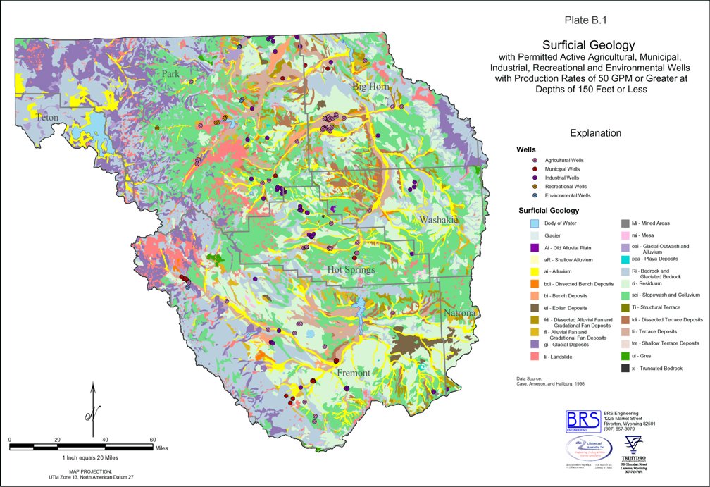
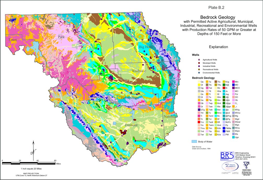
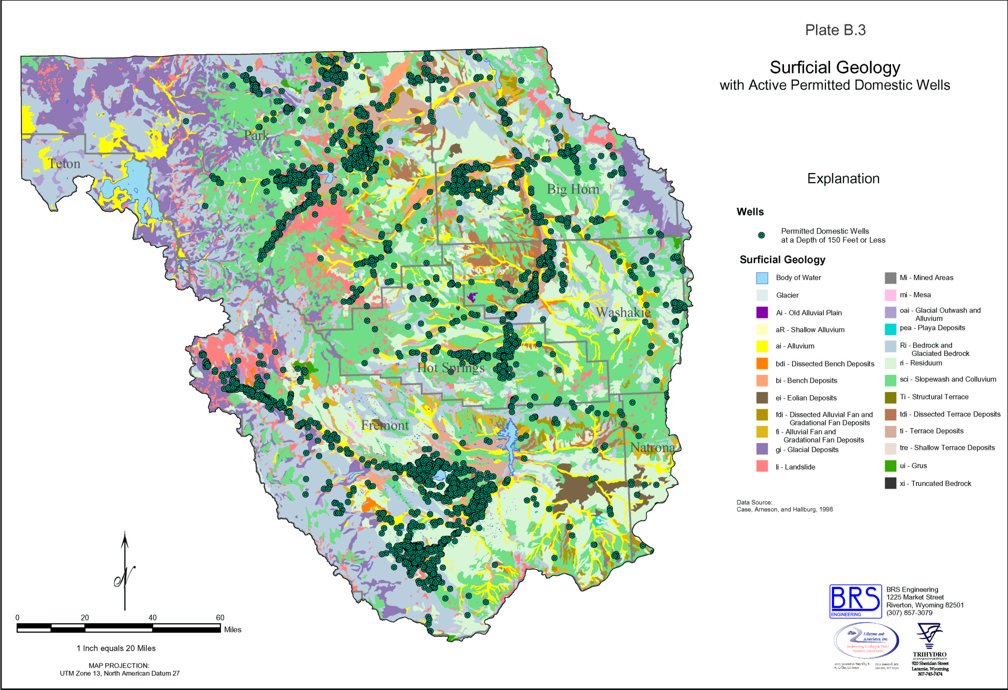
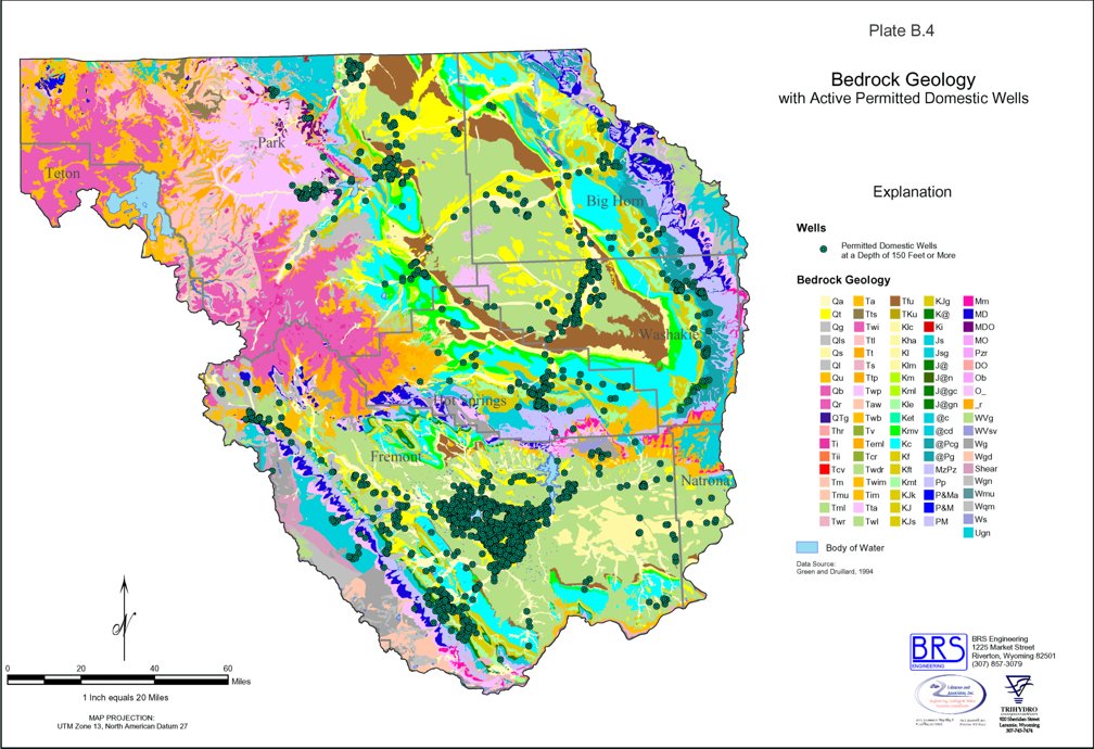
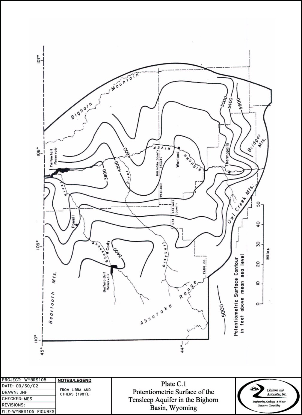
TABLE C.1.1
Hydrologic Properties of the Major Aquifers
from Oil Fields in the Bighorn Basin
| ||||||||||||||||||||||||||||||||||||||||||||||||||||||||||||||||||||||||||||||||||||||||||||||||||||||||||||||||||||||||||||||||||||||||||||||||||||||||||||||||||||||||||||||||||||||||||||||||||||||||||||||||||||||||||||||||||||||||||||||||||||||||||||||||||||||||||||||||||||||||||||||||||||||||||||||||||||||||||||||||||||||||||||||||||||||||||||||||||||||||||||||||||||||||||||||||||||||||||||||||||||||||||||||||||||||||||||||||||||||||||||||||||||||||||||||||||||||||||||||||||||||||||||||||||||||||||||||||||||||||||||||||||||||||||||||||||||||||||||||||||||||||||||||||||||||||||||||||||||||||||||||||||||||||||
|
1All transmissivities rounded to one significant figure. Transmissivity (gpd/ft) = Average Permeability (gpd/ft2) x Average Pay Thickness (ft). 2Sources are:
|
TABLE C.1.1.A
Hydrologic Properties of the Major Aquifers
from Oil Fields in the Bighorn Basin
| ||||||||||||||||||||||||||||||||||||||||||||||||||||||||||||||||||||||||||||||||||||||||||||||||||||||||||||||||||||||||||||||||||||||||||||||||||||||||||||||||||||||||||||||||||||||||||||||||||||||||||||||||||||||||||||||||||||||||||||||||||||||||||||||||||||||||||||||||||||||||||||||||||||||||||||||
|
1. Wyoming Geological Association, Oil and Gas Fields Symposium, 1957 (Supplemented, 1961) 2. Biggs and Koch, 1970 3. Wyoming State Oil and Gas Commission Files 4. Wyoming Geological Association Guidebook, 1975 5. Wyoming Geological Association Guidebook, 1952 6. All transmissivities rounded to one significant digit. Transmissivity (gpd/ft) =Average Permeability (gpd/ft2) x Average Pay Thickness (ft). From Libra and others (1981). |
TABLE C.1.2
Reported Specific Capacities and estimated Transmissivities
for the Major Aquifers from Selected Wells completed in the Bighorn Basin
Quaternary Aquifer System
|
|
1Well Data obtained from the State Engineer's Office, Cheyenne. Specific capacity (gpm/ft) = Yield (gpm) & Drawdown (ft). From Libra and others (1981). |
TABLE C.1.2.A
Reported Specific Capacities and estimated Transmissivities
for the Major Aquifers from Selected Wells completed in the Bighorn Basin
Willwood Aquifer System
|
| 1Well Data obtained from the State Engineer's Office, Cheyenne. |
TABLE C.1.2.B
Reported Specific Capacities and estimated Transmissivities
for the Major Aquifers from Selected Wells completed in the Bighorn Basin
| Formation Well Owner | Location | Test Date | Duration (hrs) | Yield (gpm) | Drawdown (ft) | Transmissivity (gpd/ft) | Specific Capacity (gpm/ft) | Remarks |
| Frontier Formation | ||||||||
| 43N-93W-3 | 8/16/76 | 20 | 50 | 500 | 0.1 | Flowing Well. | ||
| 43N-94W-5 | 2/60 | 0.25 | 44 | 6 | 7.3 | Flowing Well. | ||
| 44N-94W-35 | 7/8/73 | 1 | 20 | 17 | 1.2 | Flowing Well. | ||
| 46N-99W-24 | 10/31/55 | 24 | 64 | 237 | 0.27 | |||
| 49N-91W-4 | 5/20/53 | 0.5 | 5 | 22 | 0.23 | |||
| 49N-91W-4 | 4/30/45 | 0.5 | 20 | 30 | 0.67 | |||
| 49N-91W-4 | 10/52 | 0.5 | 20 | 30 | 0.67 | |||
| 49N-91W-20 | 4/4/74 | 20 | 20 | 80 | 0.25 | Production from sand. | ||
| 51N-93W-16 | 9/23/76 | 2 | 20 | 25 | 0.8 | Production from sand. | ||
| 51N-93W-27 | 4/25/78 | 1.5 | 20 | 10 | 2 | Production from sand. | ||
| 51N-103W-10 | 4/12/65 | 0.5 | 15 | 20 | 0.75 | Production from sand. | ||
| 52N-93W-9 | 8/57 | 168 | 200 | 58 | 3.4 | |||
| 52N-102W-21 | 6/26/74 | 0.5 | 25 | 4 | 6.2 | Production from sandstone and shale. | ||
| 52N-102W-22 | 11/11/74 | 72 | 50 | 40 | 1.2 | |||
| 52N-102W-30 | 6/16/73 | 0.5 | 30 | 5 | 6 | Production from sandstone. | ||
| 52N-102W-32 | 11/30/78 | 2.5 | 7 | 25 | 0.28 | Production from sandstone. | ||
| 52N-102W-33 | 2/15/71 | 4 | 15 | 250 | 0.06 | | ||
| 52N-103W-34 | 8/1/76 | 2 | 20 | 2 | 10 | | ||
| 53N-92W-33 | 6/22/77 | 0.17 | 10 | 90 | 0.11 | | ||
| 53N-101W-27 | 2/24/71 | 2 | 25 | 18 | 1.4 | Production from shale. | ||
| 53N-101W-27 | 4/22/71 | 2 | 20 | 9 | 2.2 | Production from shale. | ||
| 53N-101W-27 | 10/72 | 1 | 20 | 65 | 0.31 | Production from shale. | ||
| 56N-96W-15 | 5/73 | 2 | 60 | 2 | 30 | Production from shale. | ||
| Cloverly Formation | ||||||||
| 43N-96W-24 | 7/19/75 | 1 | 20 | 70 | 0.29 | |||
| 52N-102W-2 | 4/8/78 | 2 | 12 | 8 | 1.5 | Production from sandstone. | ||
| Sundance Formation | ||||||||
| 54N-94W-1 | 4/64 | 1 | 20 | 1 | 20 | |||
| 54N-94W-1 | 4/64 | 1 | 20 | 2 | 10 | |||
| Chugwater Group | ||||||||
| 52N-102W-15 | 3/15/78 | 200 | 16 | 17 | Flowing well, production from sandstone. | |||
| 52N-102W-15 | 3/10/78 | 2 | 25 | 10 | 2.5 | Production from sandstone | ||
| Tensleep Sandstone | ||||||||
| Orchard Ranch | 42N-88W-3adc | 8/19/52 | 35 | 80± | 0.47 | Flowing Well. | ||
| Orchard Ranch | 42N-88W-21bcb | 12 | 20 | 55± | 0.40 | Flowing Well. | ||
| 43N-91, 92W-6, 1 | 2 x 10² | Geometric mean, 3 wells. | ||||||
| R.C. Mills | 44N-87W-8dcd | 150± | 85 | 2.2 x 10³ | 2.0± | |||
| B.H. Ainsworth | 44N-87W-8ddc | 3.0 x 10³ | ||||||
| 44N-95W-23, 24 | 1 x 10² | Geometric mean, 2 wells. | ||||||
| 44N-98W-12,13,15 | 2 x 10² | Geometric mean, 3 wells. | ||||||
| 45N-92W-23 | 2 x 101 | |||||||
| 46N-98W-19 | 7 x 101 | |||||||
| 47N-89W-1 | 11/6/57 | 250 | 322 | 0.78 | Flowing Well. | |||
| 47N-89W-12 | 1 x 10³ | |||||||
| L.J. Davis | 47N-89W-13aab | 180± | 182 | 1.2 x 10³ 1.1 x 10³ | 1.0± | Drawdown test Recovery test. | ||
| 48N-102W-11, 14 | 2 x 10² | Geometric mean, 2 wells. | ||||||
| 48N-103W-20 | 6 x 101 | Geometric mean, 1 wells. | ||||||
| 49N-89W-21 | 30 | 60 | 0.5 | |||||
| Hamilton Ranch | 50N-90W-14bbd | 1.9 x 101 | Well originally drilled as an oil test. | |||||
| Hamilton Ranch | 50N-90W-14cac | 4.5 x 10² | Well originally drilled as an oil test. | |||||
| 51N-93W-12 | 2 x 10² | Geometric mean, 1 wells. | ||||||
| 55N-95W-3 | 1 | 25 | 5 | 5 | ||||
| 55N-95W-19 | 5 x 101 | Geometric mean, 3 wells. | ||||||
| 56N-97W-14 | 3 x 10² | Geometric mean, 2 wells. | ||||||
| 56N-101W-16 | 7 x 10² | Geometric mean, 1 wells. | ||||||
| 57N-97W-18 | 4 x 10² | Geometric mean, 2 wells. | ||||||
| Madison Limestone | ||||||||
| Taylor Brothers | 46N-87W-10acb | 125- | 289-347 | 0.43 | Specific capacity calculated from a static level of 416 ft. (180 lb/in2) above land surface. | |||
| 46N-98W-16 | 24 | 166 | 461 | 0.36 | ||||
| 46N-98W-18 | 96 | 36.5 | 62 | 0.59 | ||||
| Mark Carter | 47N-88W-5baa | 1,500± | 317 | 5.0 x 10³ | 4.7± | Recovery test. | ||
| Town of Ten Sleep | 47N-88W-16cca | 2/2/55; 9/12/02 | 0.5 | 1,100; 725 | 311; 171 | 3 x 10⁴ | 3.50; 4.2 | Flowing well, 1955 test on Madison/Amsden producing interval. 2002 test for only 0.5 hr. |
| Town of Ten Sleep | 47N-88W-17dad | 9/21/78; 9/12/02 | 24; 0.5 | 3,300; 1,100 | 259; 46 | 12.7; 23.7 | Flowing well, 2002 test completed through existing pipeline. | |
| Homer Renner | 48N-89W-4acd | 1,100 | 132 | 1.4 x 10⁴ | 7.6 | Recovery test lasted about 10 days. | ||
| Town of Hyattville | 49N-89W-6bcb | 8/68; 7/25/02 | 28-130 | 381-411 | | 0.1-0.32 | Flowing well, Recent testing indicated yield has significantly declined. | |
| Homer Renner | 49N-89W-24dcb | 5.4 x 10³ | Test was made before well was deepened to Flathead Sandstone. | |||||
| Homer Renner | 49N-89W-28baa | 5.4 x 10² | Well originally drilled as an oil test. | |||||
| D.W. Straight | 49N-89W-29abb | 8.9 x 10² | Well originally drilled as an oil test. | |||||
| City of Worland | 49N-91W-1cb | 3/3/82 | 2 | 14,000 | 20.8 | | 673 | Flowing well - Worland #3. Drawdown and specific capacity estimated from limited data. |
| City of Worland | 49N-91W-12ab | 12/28/79 | 24 | 5,180 | 25.4 | | 204 | Flowing well - Husky #1. Drawdown and specific capacity estimated from limited data. |
| Hamilton Ranch | 50N-90W-23cad | 750 1,000 | 244-486 | 2.4 x 10³ 3.8 x 10³ | 2.1-3.1 | Specific capacity calculated from static level of 521 ft (231 sl/in2) above land surface. | ||
| 50N-90W-34 | 1,650 | 518 | 3.2 | Flowing well. | ||||
| Town of Manderson | 50N-91W-17cc | 6/29/94 | 336 | 325 | 530 | 1.3 x 10³ | 0.6 | Flowing well - Wild Horse No. 1, Combined yield of Madison and Bighorn. |
| Town of Manderson | 50N-91W-20ac | 5/2/96 | 352 | 130 | 554.5 | 0.2 | Flowing well - Wild Horse No. 2, Combined yield of Madison and Bighorn. | |
| Town of Greybull | 53N-90W-19aa | 4/28/97 | 168 | 270 | 138 | 7.1 x 10³ | 1.95 | Aquifer test data following acid frac of well. |
| Town of Greybull | 53N-91W-35aa | 9/30/85 | 258 | 229 | 32.3 | 2.3 x 10³ | 7.1 | Flowing well - Shell Valley No. 1, Post frac test data. |
| 55N-94W-28 | 48 | 80 | 66 | 1.2 | ||||
| Bighorn Dolomite | ||||||||
| 47N-100W-1 | 24 | 94 | 85 | 1.11 | ||||
| Town of Greybull | 53N-91W-26dd | 9/9/85 | 492 | 1,090 | ~280 | | 3.9 | Flowing well - Shell Valley No. 2, data reflects dual completion in Madison and Bighorn. Madison yielded 345 gpm over a 7 hour test. Most flow derived from Bighorn (800 gpm.) |
| Flathead Sandstone | ||||||||
| Anderson Ranch | 47N-88W-16aba | 450- 1,500 | 859-1,207 | 0.52-1.25 | Flowing Well. | |||
| Boyd Mills | 48N-89W-25ada | 900 | 539 | 7.0 x 10² | 1.67 | Recovery test. | ||
| Homer Renner | 49N-88W-29dac | 775 1,730 | 231±-635± | 1.9 x 10³ | 2.7±-3.4± | Recover test lasted about 13 days. Specific capacity calculated from estimated static level of 693 ft. (300 lb/in2) above land surface. | ||
| 1Modified from Libra and others (1981); Cooley (1986); Morrison-Maierle (1986); Graham, Dietz, & Associates (1994); Nelson Engineering, Inc. (1997); and Lidstone and Associates, Inc. (2002). |
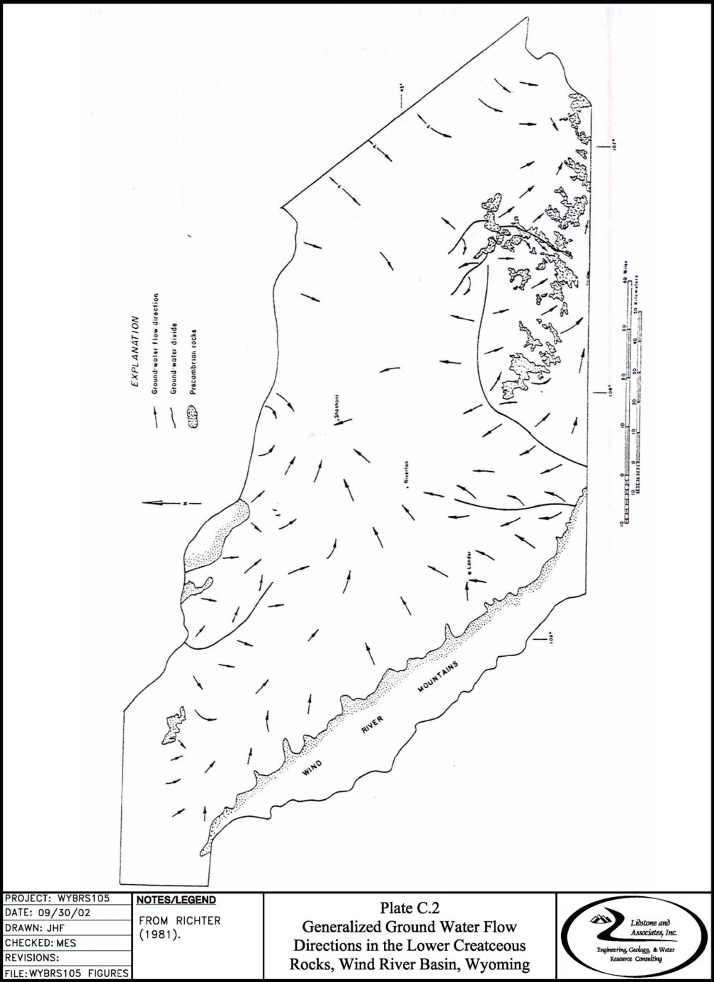
TABLE C.2.1
Hydrologic Properties of Formations
from Selected Oil and Gas Fields in the Wind River Basin
| |||||||||||||||||||||||||||||||||||||||||||||||||||||||||||||||||||||||||||||||||||||||||||||||||||||||||||||||||||||||||||||||||||||||||||||||||||||||||||||||||||||||||||||||||||||||||||||||||||||||||||||||||||||||||||||||||||||||||||||||||||||||||||||||||||||||||||||||||||||||||||||||||||||||||||||||||||||||||||||||||||||||||||||||||||||||||||||||||||||||||||||||||||||||||||||||||||||||||||||||||||||||||||||||||||||||||||||||||||||||||||||||||||||||||||||||||||||||||||||||||||||||||||||||||||||||||||||||||||||||||||||||||||||||||||||||||||||||||||||||||||||||||||||||||||||||||||||||||||||||||||||||||||||||||||||||||||||||||||||||||||||||||||||||||||||||||||||||||||||||||||||||||
|
aSources of data include Wyoming Oil and Gas Conservation Commission (various); U.S. Geological Survey (various); Wyoming Geological Association, Oil and Gas Fields Symposium (1957; supplemented 1961); Petroleum Information Corp. (various). bTownship (north) - range (west), unless otherwise specified. cmd x 18.2 x 10-3 = gallons/day/foot2. dTransmissivity estimated using T = (K) (.0182) (b), where T = transmissivity (gal/day-ft). K = permeability (md), and b = producing thickness (feet), and assuming a water temperature of 60ºF. |
TABLE C.2.2
Hydrologic Properties of Formations
from Selected Wells completed in the Wind River Basin
| |||||||||||||||||||||||||||||||||||||||||||||||||||||||||||||||||||||||||||||||||||||||||||||||||||||||||||||||||||||||||||||||||||||||||||||||||||||||||||||||||||||||||||||||||||||||||||||||||||||||||||||||||||||||||||||||||||||||||||||||||||||||||||||||||||||||||||||||||||||||||||||||||||||||||||||||||||||||||||||||||||||||||||||||||||||||||||||||||||||||||||||||||||||||||||||||||||||||||||||||||||||||||||||||||||||||||||||||||||||||||||||||||||||||||||||||||||||||||||||||||||||||||||||||||||||||||||||||||||||||||||||||||||||||||||||||||||||||||||||||||||||||||||||||||||||||||||||||||||||||||||||||||||||||||||||||||||||||||||||||||||||||||||||||||||||||||||||||||||||||||||||||||||||||||||||||||||||||||||||||||||||||||||||||||||||||||||||||||||||||||||||||||||||||||||||||||||||||||||||||||||||||||||||||||||||||||||||||||||||||||||||||||||||||||||||||||||||||||||||||||||||||||||||||||||||||||||||||||||||||||||||||||||||||||||||||||||||||||||||||||||||||||||||||||||||||||||||||||||||||