Wyoming State Water Plan
Wyoming State Water Plan
Wyoming Water Development Office
6920 Yellowtail Rd
Cheyenne, WY 82002
Phone: 307-777-7626

Wyoming Water Development Office
6920 Yellowtail Rd
Cheyenne, WY 82002
Phone: 307-777-7626


The 2014 Available Groundwater Determination Technical Memorandum No. 6 is provided in the table below. The memorandum may be
viewed in either HTML or PDF format. It is recommended that users download the latest version of Adobe Acrobat®
Reader. If you do not already have this program on your computer, please visit Adobe's Website to dowload a free copy.
For information on the Bear River Basin Groundwater from the Wyoming State Geological Survey click here.
PDF (551kb) Access the 2011 Bear River Basin Groundwater Report Executive Summary
PDF (67,461kb) Access the 2011 Bear River Basin Groundwater Final Report
PDF (3,741kb) Access the 2011 Bear River Basin Groundwater Title Page and TOC
PDF (325kb)This memorandum represents the most current assessment of the groundwater resources in the Bear River Basin
PDF (97kb)This chapter discusses the data sources, approach, organization, and computer-based mapping used in this current study and compares them to the previous Ground Water Resource Investigations contained within the 2001 and 2011 Bear River Basin Water Plans
PDF (6,222kb)This study examines groundwater resources that underlie the Bear River drainage basin in Wyoming as well as areas in Idaho and Utah that are tributary to the Wyoming part of this basin
PDF (5,336kb) A complete description of the geologic framework of the Bear River Basin must include summary accounts of the assemblages of geologic and hydrogeologic units and structural elements that define each of their geometry. To accomplish this, an extensive set of figures and maps, presented as plates, are included in this report.
PDF (25,670kb) This chapter discusses the technical concepts and terminology used in this study.
PDF (12,499kb) Discusses technical and conceptual issues concerning recharge, recharge volume estimates, and the historical development of the safe yield concept and it's technical context.
PDF (187kb) In this report, previously published data describing the physical characteristics of hydrogeologic units (aquifers and confining units) are presented on a map and summarized in tabular form.
PDF (13,434kb) This chapter discusses groundwater development, total withdrawals, and depletions in the Bear River Basin using information compiled from multiple sources
PDF (97kb) The purpose of this chapter is to discuss future water use opportunities in the Bear River Basin
PDF (78kb) References for the 2014 Bear River Basin Groundwater Study
PDF (646kb) This appendix describes the 53 digital Geographic Information System (GIS) geologic units that comprise the Bear River Basin (BRB) of Wyoming, Utah, and Idaho.
| Plate | |
| 1,062 kb | Plate I: Bedrock Geology - Bear River Basin |
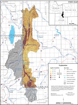
| 573 kb | Plate II: Hydrogeology - Bear River Basin |
| 843 kb | Plate 3: Location of springs, wells, and associated physical and chemical characteristics, and generalized geology - Bear River Basin, WY |
| 590 kb | Plate 4: Summaries of spring discharge, well yield, and hydraulic properties - Bear River Basin, WY |
| 91 kb | Plate 5: Relation of lithostratigraphic units to hydrogeologic units, Overthrust Belt and Fossil Basin, including Bear River Basin, WY |
| 421 kb | Plate 6: Potentiometric surface of the Bear River alluvial aquifer (modified from Glover, 1990) and generalized geology in the Cokeville area, WY |