Wyoming State Water Plan
Wyoming State Water Plan
Wyoming Water Development Office
6920 Yellowtail Rd
Cheyenne, WY 82002
Phone: 307-777-7626

Wyoming Water Development Office
6920 Yellowtail Rd
Cheyenne, WY 82002
Phone: 307-777-7626


| SUBJECT: |
Appendix N Surface Water Quality |
| PREPARED BY: | Bear River Basin Planning Team |
Introduction
The purpose of this memorandum is to identify and summarize surface water quality issues within the State of Wyoming's portion of the Bear River basin. Ground water quality issues are discussed in a separate memorandum.
Water quality issues within the Bear River basin are monitored by a number of organizations and committees. One of these organizations, the Bear River Basin Water Quality Task Force has been instrumental in the coordination of water quality work within the tri-state (Idaho, Utah, and Wyoming) basin. The Bear River Basin Water Quality Task Force was organized in 1993 by the Bear Lake Regional Commission, the Bear River Resource Conservation and Development Council, the Western Wyoming Resource Conservation and Development Council, and other government agencies and citizens interested in the Bear River basin's water quality issues. The goals of the Task Force are:
The Task Force coordinates water quality planning issues with the appropriate regulatory agencies for each state. The primary regulatory agency that manages water quality issues within Wyoming is the Water Quality Division (WQD) of the Wyoming Department of Environmental Quality (DEQ). The WQD oversees many of the water quality protection programs within Wyoming, including programs relating to point source (PS) pollution and non-point source (NPS) pollution, and the potential impacts on both surface water (SW) and ground water (GW) sources. A list of the programs regulated by the WQD is found in Attachment A of this memorandum. Attachment A also includes programs effecting water quality issues in Wyoming that are regulated by federal agencies (programs in which the state does not have primacy). The U.S. Environmental Protection Agency (EPA) empowers states to oversee their own environmental regulatory programs, so long as they meet or exceed the expectations of the federal government.
Water Quality Standards
Surface Water: The WQD developed water quality standards, which are documented in Chapter 1, Wyoming Water Quality Rules and Regulations. Chapter 1 can be downloaded from http://soswy.state.wy.us/rules/search.htm. [new link 10/2009 http://deq.state.wy.us/wqd/WQDrules/Chapter_01.pdf] The surface water quality standards are divided based on four different surface water classifications:
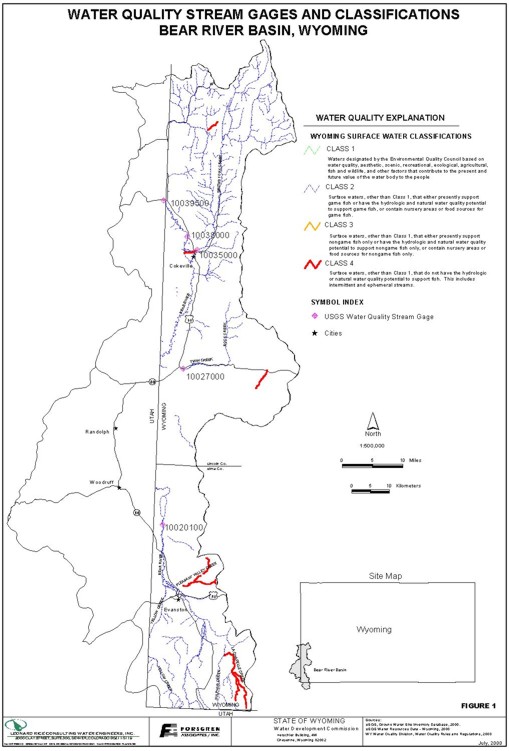
These classes can be found in Section 4 of Chapter 1. Appendix A of the WQD Wyoming Water Quality Rules and Regulations report contains the classification listing of all surface waters organized by basin. Appendix B of the WQD report lists the Water Quality Criteria for Priority and Non-Priority Pollutants. This list is categorized by Aquatic Life Acute Value, Aquatic Life Chronic Value, and Human Health Value. According to Section 18, Chapter 1, the Human Health Value shall not be exceeded in Class 1, and Class 2 waters. The Aquatic Values shall not be exceeded in Class 1, 2 and 3 waters. Class 4 waters receive protection for agricultural uses and wildlife watering. The current stream classifications for the Bear River Basin are shown in Figure 1 of this memorandum.
Interstate Water Quality Standards: The Bear River flows through three states; Idaho, Utah and Wyoming, and is administered through the Bear River Compact. This compact serves as an administrative tool for the three states and divides the basin into three divisions. Part of both the Upper and Central Divisions fall in Wyoming. Each state regulates their respective divisions water quality programs, which can either be administered by the state or by EPA. The Wyoming basin is administered by the state through the water quality standards described in the above section on Water Quality Standards.
Basin Surface Water Quality
The United States Geological Service (USGS) has four water quality monitoring stations located within the Wyoming portion of the Bear River Basin that have significant historical water quality data sets as shown in Table 1. Note that all of these stations, except station 10020100, fall within the central division of the Bear River Compact. The locations of these stations are shown in Table 1.
| TABLE 1 | |||
| Gage ID | Stream Name | Class ID | Period of Record |
|---|---|---|---|
| 10020100 | Bear River above Reservoir near Woodruff | 2 | 1985-Present |
| 10027000 | Twin Creek at Sage | 2 | 1975-1981 and 1989-Present |
| 10035000 | Smiths Fork at Cokeville | 2 | 1983-1988, 1989-1992 and 1993-Present |
| 10038000 | Bear River below Smiths Fork | 2 | 1992-Present |
| 10039500 | Bear River at Border | 2 | 1965-1989 |
Total dissolved solids (TDS) is a measure of the total amount of dissolved salts in water. Conductivity is the measure of a waters ability to conduct electricity. As the amount of dissolved salts in water increases, the number of ions increases, and hence the conductance increases. TDS is commonly derived from conductance measurements by multiplying the specific conductance by 0.6. Because it is easily measured by taking either specific conductance or TDS measurements, TDS is frequently used as an indicator of overall water quality.
Seasonal and flow based trends of TDS were plotted for the four USGS gages listed above. The EPA set a TDS standard in the Safe Drinking Water Act of 500mg/L for drinking water. No TDS criteria exists in Appendix B of Chapter 1, Wyoming Water Quality Rules and Regulations, but we understand that the surface water quality standard follows the same criteria that is set forth in the ground water quality standards. These standards are shown in Table 2.
| TABLE 2 | |||
| Pollutant | Standard according to Groundwater Classifications | ||
|---|---|---|---|
| Domestic | Agricultural | Livestock | |
| Total Dissolved Solids | 500 mg/L | 2000 mg/L | 2000 mg/L |
The following Figures 2 through 6 show that, in general, the TDS decreases with an increase in flow. This expected trend can be attributed to the source of water during different flow regimes. In the late spring and early summer, much of the flow is direct runoff from snow melt. In the late summer and non-irrigation months, much of the flow is agricultural and municipal return flows. These return flows are generally higher in TDS due to both man's influence and naturally occurring constituents in the soil.
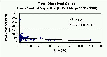
Figure 2
As shown in Figure 2, Twin Creek consistently exceeds the TDS standard for domestic use, but only exceeds the agricultural and livestock standard once in a sixteen year period (1975-1981 and 1989-1999). The primary use of lands in the Twin Creek drainage basin is for livestock grazing. If we consider the livestock water quality TDS standard as being the correct classification of Twin Creek, then TDS is not an issue. The most probable reason that TDS is higher in Twin Creek than in any other recorded segment of the Bear River basin, is due to the highly erodible shales at Twin Creek's headwaters, which contribute carbonate and salts into the drainage.
Since Twin Creek has the highest concentration of TDS in comparison to the other water quality gages in the Bear River basin, other water quality parameters at Twin Creek were studied when available. Eighteen dissolved manganese samples and 63 total nitrogen samples have been taken over the study period at the Twin Creek gage. Only two of the dissolved manganese samples are at the 50 mg/L limit for dissolved manganese as set by the Safe Drinking Water Act. All of the total nitrogen samples are lower 4 mg/L, which is far below the standard of 10 mg/L, as set in Wyoming's water quality standards for stream classifications 1 and 2. By analyzing TDS and the two additional parameters at Twin Creek, it is apparent that no water quality concerns exist for the parameters with available data.
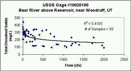
Figure 3
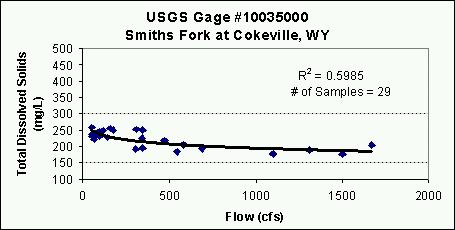
Figure 4
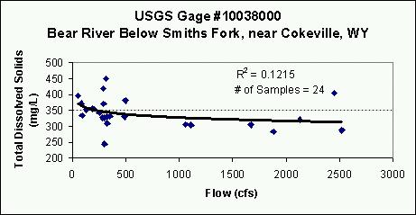
Figure 5
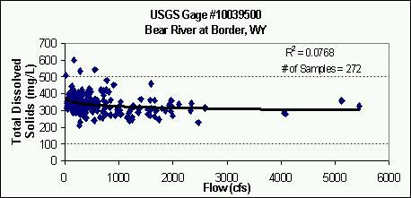
Figure 6
The remaining four USGS gages are all consistently below the domestic use standard of 500 mg/L as seen in Figures 3 through 6.
Note that all but one of the USGS gages with a longer period of water quality records are in the Central Division of the Bear River basin within Wyoming. The Upper Division has less frequent spot samples along the Bear River and, as expected, show even lower TDS values. Figure 7 shows the average TDS for the available data from the Bear River above Reservoir downstream to the Bear River below Smith's Fork and then further downstream to Border.
Figure 7
As expected, TDS increases from the Bear River above Reservoir gage to the Bear River below Smith's Fork gage, or upstream to downstream, reflecting the use, return, and reuse of the available resource. The reach from the Bear River below Smith's Fork to Border, is less than eight river miles with little development, and this is reflected in the TDS concentrations, which remain relatively constant between the two gages. Using the Bear River at Border gage as an example, Figure 8 shows that the amount of TDS measured at this gage has been relatively constant over the study period, and indicates that degradation of water quality is not a concern at this location.
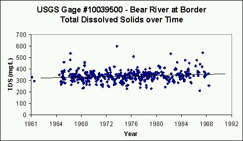
Figure 8
Total Maximum Daily Loads / 303 (d) List
Total Maximum Daily Loads (TMDLs) are the amounts of pollutants a waterbody can receive and still maintain its designated uses. TMDLs are required to be established for each pollutant that is contributing to the impairment of a waterbody. Development of TMDLs must consider both point source and non-point source pollution and additionally must account for natural background conditions.
Section 303(d) of the Clean Water Act requires States to:
This list must be reported by the States every two years. Appendix B of the year 2000 303(b) State Water Quality Assessment Report from Wyoming includes the 303(d) list. Within the Bear River Basin, Bridger Creek was listed as a waterbody with water quality threats. Bridger Creek flows through Wyoming and enters the Bear River in Utah, downstream of the town of Randolph.
A study in the early 1990's determined that Bridger Creek was a significant contributor of sediment and phosphates to Bear River. As a result of this study, a watershed improvement project was completed in 1996 and has significantly reduced loading. However, Bridger Creek remains on the 303(d) list because of potential impairment of aquatic life use support. The impairment on Bridger Creek was indicated as physical degradation due to non-point source pollution, and was listed as a low priority for developing TMDLs as seen on Table C of the 303(d) list. Two waterbodies within the Bear River Basin were delisted from the 1998 303(d) list; Yellow Creek below the Evanston Waste Water Treatment Plant, and the Bear River below the Cokeville Waste Water Treatment. These waterbodies were delisted due to the implementation of ammonia, fecal coliform and total residual chlorine TMDLs for Yellow Creek, and the implementation of fecal coliform and total residual chlorine TMDLs for the Bear River.
Conclusions
Given the available data sets, the Bear River basin has no significant water quality issues as seen at the five USGS water quality gages.
References
Bear River Basin Water Quality Task Force Presentation.
Wyoming Water Development Commission, June 2000, "Statewide Data Inventory, Bear River Basin (Overview) HUC#160101, 160201." http://waterplan.state.wy.us/sdi/BR/BR-over.html
Department of Environmental Quality, Water Quality Division, May 2000, "Upper Bear River Basin Summary." http://deq.state.wy.us/wqd/305b/bear.htm. [new link 10/2009 http://deq.state.wy.us/wqd/watershed/Downloads/NPS%20Program/00712-DOC.pdf]
Department of Environmental Quality, June 2000, "Wyoming's 2000 305(b) State Water Quality Assessment Report."
Robert Jack Smith & Associates, 1965, "Water Resources Inventory for Water Division Number 4, State of Wyoming."
United States Department of Agriculture, Soil Conservation Service, Economic Research Service, Forest Service, December 1976, "Working Paper on Water Quality for Bear River Basin Cooperative (Type IV) Study, Idaho-Utah-Wyoming."
United States Geological Survey, 1965-Present, "Water Resource Data Wyoming."
Attachment A. Water Quality Programs
| Program | Implementing Agency | Authority | Type | Program Description |
|---|---|---|---|---|
| NPDES | DEQ/WQD | EQA Article 3 Chapter 2, 4, 7, 10, 18 | SW PS | Any discharge to surface waters of the state requires a permit to discharge. Each permitted discharge must meet effluent limitations within the TMDL allocations and maintain the use of the receiving water body. There are currently 70 NPDES permits in the study area that are classified as not being a storm water permit. There are several hundred storm water permits in the study area. Information on this program is available at http://deq.state.wy.us/wqd.htm. [new link 10/2009 http://deq.state.wy.us/wqd/WYPDES_Permitting/WYPDES_Storm_Water/stormwater.asp]. |
| Permit to Construct | DEQ/WQD | EQA Article 3 Chapters 3, 5, 11, 12, 15, 20, 21 | SW GW PS | Any public water supply system or any facility capable of causing or contributing to pollution is required to obtain a permit to construct prior to commencing construction. This program is directed at ensuring facilities are designed, constructed and operated to protect ground water and surface water resources. Chapter 5 requires certified operators for public water and sewage facilities. |
| Nonpoint Source Management and Control | DEQ/WQD | EQA Article 3, Section 319 of CWA | SW GW NPS | The state nonpoint source control program is a voluntary and incentive based
program. The program seeks to control through education and encouragement of Best
Management Practices, including demonstration, information and education, and
restoration projects. Assessments and demonstration projects are selected for funding
by the Wyoming Nonpoint Source Task force. The NPS Program manages
Wyoming's allocations provided as grants by Section 319 and 205(j) of the Clean
Water Act.
Wetlands program uses a certification process to approve or deny federal permit actions concerning wetlands. Wetlands banking was established to expedite permitting. It allows industry, landowners, or others to build credits for the construction, restoration or enhancement of wetlands. These credits can be bought and sold as a means to expedite the mitigation of wetland impacts. The Nonpoint Source Management Plan is available at http://deq.state.wy.us/wqd/watershed/00712-DOC.pdf. [new link 10/2009 http://deq.state.wy.us/wqd/watershed/Downloads/NPS%20Program/00712-DOC.pdf] |
| Water Quality Assessments & Impaired Surface Water Bodies | DEQ/WQD | EQA Article 3, S. 305(b) & 303(d) of CWA | SW GW NPS PS | Section 305(b) of the Clean Water Act requires each state to assess and report on the quality of waters on a 2 year frequency. Section 303(d) requires each state every two years to list water bodies which are water quality impaired or threatened. This report and list are available at http://deq.state.wy.us/wqd/watershed/01452-doc.pdf. [new link 10/2009 http://deq.state.wy.us/wqd/watershed/Downloads/TMDL/tmdlinfo.htm] |
| Surface Water Monitoring | DEQ/WQD | EQA Article 3 | SW PS NPS | The WQD is progressing toward a more comprehensive monitoring and assessment program. In 1996, the Legislature passed a credible data law requiring the WQD to ensure all data used in listing impaired or threatened waters requiring scientifically valid data to be used. This credible data law has significantly increased monitoring of surface water in Wyoming. Monitoring efforts by WQD to comply with the credible data law are contained in the 305(b) report. |
| 404 Permit | US Army Corps of Engineers | Clean Water Act | SW PS NPS | A permit is required from the Army Corps of Engineers to discharge dredge or fill material into navigable waters. |
| 401 Certifications | DEQ/WQD | EQA Article 3 | SW PS, NPS | Any application for an Army Corp of Engineers 404 dredge and fill permit requires a certification from WQD that the dredge or fill will comply with all the requirements of Sections 301,302,303, 306 & 307 of the Clean Water Act. |
| Spill Program | DEQ/WQD | EQA Article 3 Chapter 4 | SW GW PS | Any person owning or having control over oil or a hazardous substance, which after release, enters or threatens to enter waters of the state shall take action to stop and contain the release, notify WQD, correct the cause, clean up the release and dispose of the waste in an acceptable manner. |
| Source Water Protection | DEQ/WQD | EQA Article 3 | SW GW | Wyoming has developed a voluntary source water protection program as required by each state under Section 1453 of the SDWA. Source water assessment involves four steps: delineate the area which contributes water to the well or surface water intake; inventory of potential sources of contamination; complete an analysis of the susceptibility of the well or intake to contamination from the previous inventory; and draft up a report summarizing the findings. |
| Wellhead Protection Program | DEQ/WQD | EQA Article 3 | GW | Wyoming has developed and received approval from EPA endorsing its wellhead protection program developed pursuant to Section 1428 of the SDWA. The program is voluntary and allows public water supply systems to protect groundwater sources of supply. |
| Wellhead Protection Program | DEQ/WQD | EQA Article 3 | GW | Wyoming has developed and received approval from EPA endorsing its wellhead protection program developed pursuant to Section 1428 of the SDWA. The program is voluntary and allows public water supply systems to protect groundwater sources. |
| Abandoned Mines | DEQ/AML | Article 12 | PS NPS SW GW | The abandoned mines program accomplishes reclamation of eligible properties adversely affected by mining prior to August 3, 1977. Eligible Public facilities and utilities adversely affected by mining prior to August 3, 1977 and the construction of new public facilities or utilities in communities impacted by coal or mineral mining and processing practices. |
| Landfills & Hazardous Wastes | DEQ/SHWD | EQA Article 5 | PS SW GW | No person, except when authorized by a SHWD permit, shall locate, construct, operate or close a solid waste management facility or modify the design, construction or operation of a solid waste management facility. The SHWD has primacy of the federal RCRA program regulating hazardous waste generators and transporters, hazardous waste treatment, storage and disposal facility operators, and hazardous waste corrective actions. |
| Superfund Sites | US EPA | CERCLA | PS SW GW | EPA regulates superfund sites in Wyoming. |
| Well Construction & Abandonment | WY State Engineer (SEO) | SEO Regulations | PS GW | The state engineer has regulations requiring adequate design, construction and abandonment of wells to protect groundwater resources. |
| Colorado River Salinity Standards | AZ, CA, CO, NV, NM, UT, WY | P.L. 93- 320 Forum Policies WY/WQD Ch. 6 | SW GW PS NPS | The 7 states in the Colorado River Basin form an interstate forum with a goal directed at maintenance of water quality so that numeric criteria are not exceeded in the lower basin. The forum has developed policies for surface water discharges from municipal and industrial sources as well as natural occurring groundwater and fish hatcheries. The Big Sandy Salinity Project in Wyoming was directed at NPS returns to SW and GW from agricultural irrigation operations. |
| Wellhead Protection Program | DEQ/WQD | EQA Article 3 | GW | Wyoming has developed and received approval from EPA endorsing its wellhead protection program developed pursuant to Section 1428 of the SDWA. The program is voluntary and allows public water supply systems to protect groundwater sources of supply. |
| Underground Storage Tanks | DEQ/WQD | EQA Article 14 | PS SW GW | Wyoming has primacy of the federal RCRA program regulating underground storage tanks (UST). This program regulates the design, construction and operation of USTs and provides financial responsibility for UST and commercial above ground storage tank owner/operators. In addition, a cleanup fund exists to remediate contamination caused by leaking USTs. |
| Underground Injection Control Wells | DEQ/WQD | EQA Article 3 Chapters 13 & 16 | PS GW | Any person who construct, installs, or operates a Class I, IV, or V underground injection control well must first obtain a permit from the DEQ/WQD. Class I wells are deep injection wells that discharge into a Class VI groundwater formation and include hazardous waste wells of which there are none in Wyoming. Commercial Class II wells are regulated as a Class I well. Class IV wells inject hazardous waste into shallow aquifers and are prohibited. Class V wells are wells, other than the other 4 classifications, injecting into or above underground sources of drinking water such as drain fields, air conditioning return wells, dry wells, etc. |
| DEQ/LQD | Article 4 | Any person injecting into a class III well must obtain a permit or license from DEQ/WQD. A class III well injects into or above a drinking water for the purpose of extracting minerals. The most common in situ mining wells in Wyoming are uranium and soda ash. | ||
| OGCC | W.S. 30- 5-101 thru 305 | Any person injecting into a noncommercial class II well is required to obtain a permit from the Wyoming Oil and Gas Conservation Commission. Class II wells inject fluids which are brought to the surface in connection with natural gas storage operations or conventional oil and gas production, fluids for enhanced recovery of oil or natural gas and for storage of hydrocarbons. | ||
| State Pesticide Management Plan (SMP) | WY Dept. of Agriculture | W.S. 35- 7-350 thru 374 | NPS SW GW | The Department of Agriculture has developed a SMP directed at the protection of water resources from the application of pesticides. The SMP program has received EPA approval. |
| SMP GW Monitoring | WY Dept. of Agriculture | W.S. 35- 7-350 thru 374 | GW | Utilizing pesticide registration fees and funding from 319 grants, the USGS has been contracted to conduct a state-wide assessment of the contamination of groundwater caused by pesticides. Of the counties completed at the time of this report, no levels above drinking water maximum contaminant levels have been found. Monitoring results can be accessed at http://wy.water.usgs.gov/projects/pesticide/. |
| Mines | DEQ/LQD | EQA Article 4 | PS NPS SW GW | License or permits are required for any mining operation or operation by which solid minerals are intended to be extracted from the earth. This includes surface and underground mining. The extraction of sand, gravel, dirt, scoria, limestone, dolomite, shale, ballast, or feldspar by a landowner for noncommercial use does not require a permit nor does an area of less than 10 surface acres under certain conditions. |