Wyoming State Water Plan
Wyoming State Water Plan
Wyoming Water Development Office
6920 Yellowtail Rd
Cheyenne, WY 82002
Phone: 307-777-7626

Wyoming Water Development Office
6920 Yellowtail Rd
Cheyenne, WY 82002
Phone: 307-777-7626


| SUBJECT: |
Appendix I Whitney Reservoir |
| PREPARED BY: | Bear River Basin Planning Team |
| DATE: | July 25, 2000 |
Location: Section 9, Township 1N, Range 9W. Located on the West Fork of the Bear River in Utah, approximately 38 miles upstream from Evanston, Wyoming.
Year of construction: 1966
Ownership: Upper Bear River & Mill Creek. Contact is Sam Lowham, 18907 Hwy 150, Evanston, Wyoming 82930
Total Storage: 4,700 acre-feet
Active Storage: acre-feet
Dead Storage: acre-feet
Area/Capacity Data: At the spillway elevation, area = 188 acres, capacity = 4700 acre-feet
| Whitney Reservoir Capacity Table | Elevation | Area (acres) |
Cumulative Capacity (acre-feet) |
|---|---|---|
| 50 | 0 | 0 |
| 60 | 105 | 100 |
| 70 | 220 | 430 |
| 80 | 265 | 900 |
| 90 | 360 | 1580 |
| 100 | 470 | 2400 |
| 110 | 640 | 3550 |
| 118 (spillway) | 188 | 4,700 |
Note: Data is interpolated from area capacity curve shown on reservoir design drawings.
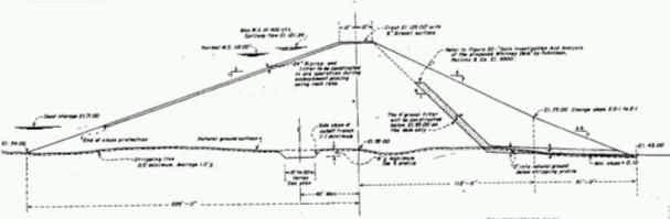
Dam Construction Type: Earth-fill with rock face.
Outlet: 28-inch Diameter reinforced concrete pipe. Outlet capacity = 135 CFS
Spillway: "Duckbill" type spillway, 1650 CFS capacity
Enlargement History: None
End of Month Storage / Release Records: End of month storage records do not appear to have been consistently maintained. Detailed daily release records are available as shown on the attached table.
Water Rights:
| Whitney Reservoir Permitted Storage Rights | |||
| Permit No. | Priority | Volume (acre-feet) |
Comments |
|---|---|---|---|
| 21-1044 | 4200 | Utah Water Right | |
Designated Use: Irrigation and Stock
Recreational Use: Whitney Reservoir is a popular fishing and campsite location. Access is via the Mirror Lake Scenic Byway.
Associated Irrigation Diversions:
| WHITNEY DIVERSIONS | |
| Irrigation Diversion | Associated Whitney Storage Right (approx) (acre-feet) |
|---|---|
| Hilliard East Fork | 693 |
| Lannon & Lone Mountain | 512 |
| Hilliard West Side | 508 |
| Bear Canal | 1103 |
| Crown & Pine Grove | 600 |
| McGraw & Big Bend | 220 |
| Lewis Ditch | 115 |
| Myers No. 2 | 191 |
| Danielson Ditch | 79 |
| Coffman | 123 |
| Tropic | 41 |
| TOTAL | 4,185 |
It should be noted that the irrigation diversion volumes listed are approximate
only. Some share holders utilize multiple diversions depending upon their needs.
Associated Industrial Diversions: None.
Operational Discussion: Hilliard East Fork Ditch obtains supplemental water from Whitney Reservoir by exchange.
Resources:
1) Utah Division of Water Resources Website, http://161.119.67.1/cgi-bin/damprt?UT00324
2) Water rights shareholders list provided by Don Shoemaker, Wyoming Water Hydrographer- Commissioner for the Upper Division of the Bear River.
3) Glenn L. Enke – ConsultingEngineer, As Constructed Drawings of Whitney Dam, October 1996
BEAR RIVER STORAGE (Wyoming Section-Upper Division)
WHITNEY RESERVOIR
| AVERAGE MONTHLY RELEASE (Acre-Feet) | ||||||
| YEAR | APRIL | MAY | JUNE | JULY | AUGUST | SEPTEMBER |
|---|---|---|---|---|---|---|
| 1986 | 12.3 | 545.5 | 2,325.4 | 78.5 | 49.6 | 2498.4 |
| 1987 | 59.5 | No Record | No Record | 2,756.6 | 324.3 | 59.5 |
| 1988 | 59.5 | Spilling | Spilling | 2,867.1 | 287.4 | 159.7 |
| 1989 | 59.5 | No Record | No Record | 2,409.9 | 2,346.4 | 99.6 |
| 1990 | 59.5 | 61.5 | 99.2 | 3,046.6 | 528.0 | 77.4 |
| 1991 | 59.5 | Spilling | Spilling | 2,800.7 | 617.7 | 800.0 |
| 1992 | 59.5 | 25.8 | Spilling | 1,446.0 | 1,570.9 | 251.5 |
| 1993 | 59.5 | 61.5 | Spilling | Spilling | 61.5 | 3,286.6 |
| 1994 | 59.5 | Spilling | 263.8 | 3,587.5 | 754.1 | 3,295.1 |
| 1995 | 59.5 | 61.5 | 1,959.7 | 178.3 | 542.1 | 3,655.5 |
| 1996 | 92.2 | 1,803.0 | 2,122.3 | 1,176.2 | 1,924.6 | 2,300.8 |
| 1997 | 92.2 | 92.2 | 1,318.6 | 1,616.5 | 723.0 | 888.4 |
| 1998 | 190.4 | 3,596.0 | Spilling | 1,512.4 | 108.9 | 1,805.2 |
| 1999 | 104.5 | 250.9 | 2,390.1 | 1,106.8 | 699.0 | 1,525.1 |