Wyoming State Water Plan
Wyoming State Water Plan
Wyoming Water Development Office
6920 Yellowtail Rd
Cheyenne, WY 82002
Phone: 307-777-7626

Wyoming Water Development Office
6920 Yellowtail Rd
Cheyenne, WY 82002
Phone: 307-777-7626


| SUBJECT: |
Appendix I Sulphur Creek Reservoir |
| PREPARED BY: | Bear River Basin Planning Team |
| DATE: | July 20, 2000 |
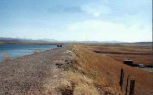
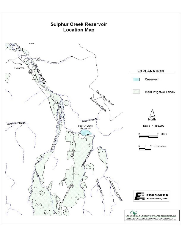
| Location: | Section 34, Township 14N, Range 119W. Located on Sulphur Creek, tributary to the Bear River. Located approximately 20 miles southeast of Evanston. |
|
| Ownership: | Sulphur Creek Reservoir Company and the City of Evanston) |
Year of construction: 1959
Enlargement History: 1958 Enlargement
1982 Enlargement (Constructed 1989)
Total Storage: 19,774.84 acre-feet
Active Storage: 19,288.72 acre-feet
Dead Storage: 486.12 acre-feet
4180 acre-feet minimum conservation pool
Area/Capacity Data:
| Sulphur Creek Reservoir Capacity Table | ||
| Elevation | Area (acres) |
Cumulative Capacity (acre-feet) | 7120 | 0 | 0 | 7130 | 75 | 200 | 7140 | 150 | 1400 | 7150 | 250 | 2600 | 7160 | 350 | 5200 | 7170 | 460 | 10,500 | 7180 | 570 | 14,500 | 7187 (Normal High Water) | 632 | 19,808.98 |
|---|---|---|
Dam Construction Type: Earth-fill with rock face
| Outlet: 48-inch diameter steel outlet pipe through the dam that splits into 4 outlet pipes at the downstream control house. The 48-inch outlet pipe continues through the control house for reservoir evacuation (capacity 460 CFS). The other 3 outlet pipes branch off of the 48-inch outlet pipe and include an 8-inch diameter low flow outlet pipe (capacity 11.8 CFS), a 24-inch diameter irrigation flow outlet pipe (capacity 128 CFS), and a 36-inch municipal outlet pipe (capacity 190 CFS). Note: All flows are at NHWL = 7187 ft. elevation. | 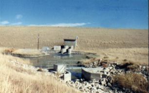 Sulphur Creek Outlet Structure |
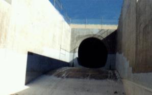 Sulphur Creek "Glory Hole" Spillway |
Spillway: Glory hole type spillway: | End-of-Month Storage records: Not available. | Water Rights: The table below represents the four permits that have been issued for Sulphur Creek Reservoir. |
| Sulphur Creek Permitted Storage Rights | |||
| Permit No. | Priority | Volume (acre-feet) |
Comments |
|---|---|---|---|
| 1958 Compact Rights | |||
| 5695R | 2-14-1950 | 4103.13 | Original |
| 6481R | 8-21-1958 | 510.41 | 1st Enlargement |
| 6562R | 10-1-1958 | 1100 | 2nd Enlargement |
| 6562R & 9222R | 10-1-1958 | 428.85 | Carryover & Surplus |
| Amended Compact Rights | |||
| 9222R | 9-8-1982 | 1402 | Irrigation |
| 9222R | 9-8-1982 | 9370 | Evanston Municipal |
| 9222R | 9-8-1982 | 2373.33 | Carryover & Surplus |
| 9222R | 9-8-1982 | 486.12 | Inactive |
| Total Maximum Annual Storage | 16,486.54 | Does not include carryover or Inactive Rights. | |
The 428.85 acre-feet of carryover storage is jointly shared capacity. The limitations of permit 9222R states; “for irrigation … 428.85 acre-feet available to store surplus water or as carryover capacity (jointly shared capacity occupying common storage space with 428.85 acre-feet of carryover capacity in Permit No. 6562R under Compact Article VI-A).”The total maximum annual storage shown in the table does not include carryover, surplus, or inactive storage rights. If “surplus” water is available under Article VI-C of the Compact, then an additional 2,802.18 acre-feet (2773.33 acre-feet City of Evanston surplus + 428.85 acre-feet irrigation surplus) can be stored bringing the total to 19,288.72 acre-feet.
Designated Use: Irrigation and Municipal
Recreational Use: Sulphur Creek Reservoir is a popular fishing and boating location. In the winter it is a popular ice fishing location and has been the site of the annual Lion’s Club Ice Fishing Derby for the past several years.
Associated Irrigation Diversions: Based on a listing of current reservoir share holders and their respective lands, a tabulation of associated diversions is as follows:
| SULPHUR CREEK RESERVOIR DIVERSIONS | |
| Irrigation Diversion | Associated Sulphur
Creek Storage Right (acre-feet) |
|---|---|
| Hilliard East Fork | 967 |
| Bear Canal | 250 |
| Myers No. 2 | 85 |
| Myers No. 1 | 142 |
| Evanston Pipeline (municipal) | 12,837 |
| Booth | 823 |
| Anel | 104 |
| Cornelison | 223 |
| Evanston Water Ditch | 1403 |
| Rocky Mtn. & Blythe | 303 |
| John Sims | 592 |
| S.P. (Ramsey) | 372 |
| Chapman Canal | 35 |
| Morris Brothers Irrigation | 55 |
| Browns/Russel | 141 |
| Sims/Blight/Turner | 31 |
| Fannon | 190 |
| Almy | 76 |
| Saxton Irr. | 21 |
| Bruce-Barton | 70 |
| A.W. Sims | 70 |
| Misc. & Not Used | 410 |
| TOTAL | 19,200 |
It should be noted that the irrigation diversion volumes listed are approximate only. Some shareholders utilize multiple diversions depending upon their needs. Diversions located upstream of the Bear River – Sulphur Creek confluence utilize Sulphur Creek storage by exchange.
Associated Industrial Diversions: None
Operational Discussion: Sulphur Creek Reservoir has an irrigation account and an Evanston municipal account. It is filled with native Sulphur Creek water, water from Bear River through the Evanston Pipeline, plus return flow from ditches that divert from the Bear River (Hilliard East Fork, Hilliard West Side, and the Bear Canal). A minimum flow of 35 CFS from Nov. 1 to March 31 and 115 CFS from April 1 to Oct. 31 must be met on the Bear River before diversions can be made through the Evanston Pipeline. A minimum pool of 4180 ac-ft in Sulphur Creek Reservoir and minimum releases to Sulphur Creek of 9 CFS must be maintained. Wyoming has allowed Woodruff Narrows, Broadbent, and Sulphur Creek Reservoirs to temporarily store a portion of their unconstructed original compact allocated storage when Bear Lake levels dropped below elevation 5911 in the early 1990’s.
Resources:
1) Sue Lowry, Summary of 1958 Bear River Compact Allocations, Bear River Basin, Wyoming; October 1990;
2) Sue Lowry, Policy Definition Regarding the Storage of Water in Woodruff Narrows and Sulphur Creek Reservoirs; October 1990
3) Bear River Compact as Amended, Amended Compact Unanimously Approved December 22, 1978 by Duly Appointed Commissioners from those states of Idaho, Utah, and Wyoming, Ratified by the Legislatures of all 3 states in 1979, Congressional Consent Public Law 96- 189 February 8, 1980.