Wyoming State Water Plan
Wyoming State Water Plan
Wyoming Water Development Office
6920 Yellowtail Rd
Cheyenne, WY 82002
Phone: 307-777-7626

Wyoming Water Development Office
6920 Yellowtail Rd
Cheyenne, WY 82002
Phone: 307-777-7626


| SUBJECT: |
Appendix E Irrigated Lands GIS Data |
| PREPARED BY: |
Mike O'Grady, States West Water Resources Corporation Frank Carr, Water Right Services, LLC Jack Meena, States West Water Resources Corporation |
Irrigated Lands Mapping Process – Bear River Water Plan
States West Water Resources Corporation was contracted by the Wyoming Water Development Commission Office in November 1997. One of our tasks was to develop GIS mapping of all recently irrigated lands within Wyoming's Bear River Basin. The process was based upon four general phases, all of which are described below. In general, States West developed mapping of all currently irrigated agriculture (1998).
Aerial and Satellite Photography Interpretation and Mapping
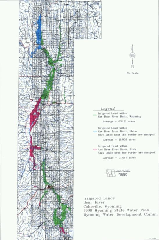
Aerial photos were obtained from the Wyoming Water Development Commission (WWDC) offices in Cheyenne, Wyoming. This photography is quadrangle-centered, quadrangle-scale (1:24,000) color infra-red (CIR) film positives. This photography was obtained for Wyoming by Mark Hurd Aerial Surveys in the summers of 1983/84 and was conducted under the direct supervision of Mr. Michael O'Grady. Mr. O'Grady served as the project manager for Water Division IV (Green, Snake, and Bear River Basins) for the Wyoming Water Development Commission at that time. Figure 1 illustrates the final mapping portion of the project. Irrigated lands outside the State of Wyoming that appear on the CIR photography were included in the mapping. However, these lands do not comprise all irrigated lands in the Bear River Basin. They are simply all those lands in close proximity to the State of Wyoming.
This mapping project was performed similar to the first comprehensive irrigated lands mapping of the basin, conducted for the Bear River Basin Water Plan, 1970. That mapping is described in a document (Report #9) published by the Wyoming Water Planning Program (WWPP) in September 1970 and entitled "Water and Related Land Resources of the Bear River Basin, Wyoming."
For the present mapping, States West obtained 7.5 minute digital vectorized USGS quadrangle coverage for the irrigated portions of the Bear River Basin. On figure 1, the overlaid lines represent the vectors. These AutoCad files contain all roads, hydrography, section lines, pipelines, trails, and other quadrangle features excluding topography. The digital quadrangles were then plotted onto clear mylar and used to directly overlay the WWDC photography. The procedure followed was to determine base irrigated polygons using the WWDC photography with recent changes (additions to or deletions from the base) determined from field checking. It is important to note that not all roads, canals, ditches, power lines, etc. were excluded from the irrigated polygon. This is because at 1:24,000 scale imagery the width of an interpreted boundary is approximately 100 feet. To attempt to exclude these small linear features or very small polygons from an irrigated polygon would only increase the error in assessing the total irrigated acreage. Upon completion of the irrigated land interpretation, the final mylar plots consisted of the original background information, irrigation according to the earlier WWDC photography and the changes illustrated by the field check. This product forms the basis of all the digital coverages produced for irrigated lands in the study basins.
A large format Summagraphics LCL digitizer provided the conversion from the manual interpretation into a digital format. This device permits resolutions up to 1000 lines per inch. The necessity to digitize every polygon in the state plane coordinate system requires the equipment to be recalibrated for each map or anytime work is suspended. For verification of the actual digitizing, comparisons were made between the photography, field checks, manual interpretation sheets, screen images, and subsequent plots. A minimum of three checks was completed to ensure the accuracy of the comprehensiveness of the final product.
The fundamental criterion used in the identification of irrigated lands is as follows: "Irrigated land is all land that can be identified as receiving water induced by the works of man." This interpretation criteria is consistent with that used in the Upper Colorado River Compact and other recent mapping projects performed by Mr. O'Grady. A similar definition which could also be used is found on page 58 of the North Platte River United States Supreme Court Decree (Doherty, 1943): "The term 'acreage irrigated' needs to be clarified. Much of testimony relates to what may be referred to as the 'right' acreage, that is acreage having an existing water right. As used in this report, 'acreage irrigated' refers only to such 'right' acreage as currently demanding and using water. The maximum limit would be the greatest acreage irrigated in any one year, assuming a water supply sufficient to permit full irrigation."
It is commonly recognized that all lands that are capable of being irrigated are not always irrigated in a given year. A number of factors may influence the actual farming and irrigation practices in a given year resulting in greater or fewer acres actually being irrigated. These factors include the available water supply (e.g., many junior water rights have no water available in some years or may be out-of-priority after the spring runoff concludes in late May), local, regional and even national economic conditions (including farm product prices, labor, real estates values, etc.), climatic conditions such as severe weather, and the individual decisions that each landowner makes with respect to the use of his/her land in a given year.
Field Verification
Upon completion of draft irrigated lands mapping, irrigated polygons were digitized in AutoCad and transferred to Arc-Info via ArcCad software. Draft final mapping was then plotted onto bond paper and distributed to the appropriate Wyoming State Engineer's Office field personnel for field verification. For the Bear River Basin, the plots were sent to Jade Henderson, Division IV Superintendent. Field personnel delineated any changes on those maps that may have occurred since the date of the aerial photography. Most changes related to water transfers and/or abandonments since the date of satellite acquisition.
Final GIS Products –Database
Irrigated Lands Database
The creation of the GIS coverage was performed by Mr. Jack Meena. Mr. Meena is a
professional engineer and a GIS manager for States West.
Along with acreage, four other items were added to the irrigated lands GIS coverages. The first, the quadrangle name, was used to help located the lands. The next item, island identifier, is a simple flag field used to help sort out non-irrigated polygons inside irrigated polygons. This item helps to efficiently eliminate lands that are not irrigated. The last item, state name, was added to assist in the determination of irrigation within each state. The states having lands in the coverage are as follows:
Summary
Table 1 dissects the basins into two smaller drainages and provides totals for each basin compared to the 1970 mapping.
Table 1 – Irrigated Land Totals by Sub-Basin.
| Area | 1970 Irrigated Lands (acres) |
1998 Irrigated Lands (acres) |
Difference (acres) |
| Bear River Basin above Woodruff Narrows | 31,321 | 31,102 | -219 |
| Bear River Basin below Woodruff Narrows | 27,370 | 32,029 | +4,659 |
| TOTALS | 58,691 | 63,131 | +4,440 |
Appendix A – Wyoming Water Rights Terminology
Surplus Water: Whenever the supply of water in a stream reaches the point where there is water available over and above the needed to fill all appropriations with a priority senior to March 1, 1945, then this stream is in surplus flow condition. When surplus flows are available, the water is to be divided proportionally among the senior rights up to an additional 1.0 cfs to every 70 acres or 1.0 cfs to every 35 acres total supply. (W.S 41-3-319-324)
Excess Water: Each water right with a priority date of post March 1, 1945 but pre March 1, 1985 is entitled to 2.0 cfs for every 70 acres before any water is made available to post March 1, 1985 water rights. If there is insufficient water to furnish 2.0 cfs to each post March1, 1945 and pre March 1, 1985 water right, but more than enough to furnish 1.0 cfs to each of these rights, the excess water is divided among those rights on a pro- rata basis. (W.S. 41-4-330)
Territorial Appropriation: This is an appropriation of water with a priority date prior to statehood. These rights were filed under a system of statement of claims to water under territorial law rather than a permit system. They were adjudicated after statehood by the then-established State Board of control. No permits numbers were assigned to those water rights, and they can be identified only by the proof number.
Direct Flow Appropriation: This is an appropriation of water that diverts from a surface water source and is measured in cubic feet per second (cfs). The appropriation is granted by the State Engineer and gives the appropriator the right to divert water as set out in the permit. The statutes set the amount of diversion for irrigation at a rate of 1.0 cfs for every seventy (70) acres to be irrigated. (W.S. 41-3-317)
Unadjudicated Permit: This is a permit that has not been fully perfected. It can be in the construction stage through the application of water to beneficial use. When the permit is issued by the State Engineer, the applicant is given time limits to commence construction, complete construction, and apply the water to beneficial use. While all this is taking place the permit is considered as "unadjudicated".
Adjudicated Permit: This is a permit where the notice of completion of beneficial use has been filed, proof of appropriation prepared, a field inspection made with the finding that the facility is built within the terms of the permit, the proof advertised with no protests, and the proof considered and allowed b the State board of Control. After these items are completed, an order of the Board and the Certificate of Appropriation are prepared, issued, and recorded in the court house of the respective county and made a matter of record in the Tabulation of Adjudicated Water Rights.
Storage Right (Reservoirs): This is a permit that allows an appropriator to store or impound for beneficial purposes unappropriated water. Water can be stored for irrigation, stock, municipal, fish, recreational, and other purposes, provided that a permit is secured from the State Engineer. Upon completion of reservoir construction, the storage right is considered as being put to beneficial use. (W.S. 41-3-301)
Secondary Application: A Secondary permit may be secured by filing with the State Engineer a secondary application solely for the purposes of attaching water stored for irrigation purposes to specific lands. The application requests that a certain number of acre-feet of stored water be allocated to specific lands. Once the application is granted, te allocated water cannot be used on any other lands or for any other purpose.
Supplemental Supply: direct flow water from a different source and different point of diversion to augment or supplement the available water for an existing appropriation (water right) for which the original source does not provide a full supply constitute a supplemental supply. The amount of supplemental water which may be diverted is the amount available, in priority, to bring the total water diverted from all sources up to the appropriated amount of 1.0 cubic foot per second (cfs) for every 70 acres to be irrigated. (W.S. 41-3-113)
Court Decrees: A small number of water rights were confirmed (adjudicated) by court decrees prior to the creation of the State Board of Control.
Original Supply Groundwater: Groundwater is appropriated in gallons per minute (gpm). Original supply is a water right attached to land or uses where there is no other water right of record. It is the first priority water right attached to and to be used on the identified land.
Additional Supply Groundwater: Additional supply is additional water to lands or uses which already have a valid existing water right. It can be additional water to surface water irrigation and/or groundwater irrigation. Additional groundwater is measured in gallons per minute (gpm).
Unadjudicated Groundwater: A valid groundwater permit (well permit) which is in the process between the issuance of the permit and completion of beneficial use, I.e., construction, pump testing, application of water to beneficial use, mapping, and filing the necessary paper work to begin the adjudication process is considered unadjudicated.
Adjudicated Groundwater: A groundwater permit (well permit) where notice of completion of beneficial use has been filed, the adjudication map prepared and filed, proof of appropriation prepared, inspected and advertised with no protests received, proof considered by the State Board of Control and allowed, Certificate of Appropriation prepared, issued, and recorded in the respective county court house is considered adjudicated. The appropriation is made a matter of record in the Tabulation of Adjudicated Water Rights.
References
The following is a list of documents relied upon in the preparation of this technical memo and associated data:
Carr, Frank, 1999-2000, "Water Rights Attribution Mapping", Maps and spreadsheets.
Doherty, Michael J., Special Master, 1943, "Supreme Court of the United States, No. 7 Original, October Term, 1943."
Wyoming State Engineer's Office, Original water right records for surface and groundwater permits.
Wyoming Water Development Commission, 1983-1984, Color Infra-Red Photography, Statewide Photography Program.
Wyoming Water Planning Program, 1971, "Report #7 Irrigated Lands Inventory for Wyoming," prepared by Hunter, Trelease, Bilyeu.
Wyoming Water Planning Program, 1971, "Report #9 Water & Related Land Resources of the Platte River Basin, Wyoming."